Articoli correlati a Handy Map Dublin
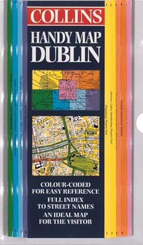

3.5 inches to 1 mile 1:18,000 approx This full colour map with street level detail and index to streets is very easy to use and has a durable laminated surface.
MAIN FEATURES
� Unique ‘easyfold’ pattern
� Colour coded map areas
� Durable laminated map in a clear plastic wallet
INCLUDES
� Clear updated street mapping
� Full index to street names
� Shows classified roads in colour
� Includes all important buildings and places of interest
AREA OF COVERAGE
From Palmerston in the west to Dollymount in the east and from Glasnevin in the north to Milltown in the south.
WHO THE PRODUCT IS AIMED AT
Essential for the visitor and tourist exploring the City of Dublin.
Le informazioni nella sezione "Riassunto" possono far riferimento a edizioni diverse di questo titolo.
Dalla quarta di copertina:
These innovative maps open like a book with a neat, concertina-style fold easy to read and easy to fold. Each map is laminated for extra protection and is presented in a plastic wallet. The maps divide the city into sections and a colour-coding system ensures that the desired area is easily found.
Laminated on both sides and inserted into a handy plastic wallet, this map is extremely durable. The distinctive fold makes use extremely easy, it is almost like using an atlas, with the benefits of a map.
This revised edition covers the area from Palmerston in the west to Dollymount in the east and from Glasnevin in the north to Milltown in the south
This full colour map with street level detail and index to streets is very easy to use and has a durable laminated surface
Le informazioni nella sezione "Su questo libro" possono far riferimento a edizioni diverse di questo titolo.
- EditoreCollins
- Data di pubblicazione2000
- ISBN 10 0004489632
- ISBN 13 9780004489636
- RilegaturaMappa
(nessuna copia disponibile)
Cerca: Inserisci un desiderataSe non trovi il libro che cerchi su AbeBooks possiamo cercarlo per te automaticamente ad ogni aggiornamento del nostro sito. Se il libro � ancora reperibile da qualche parte, lo troveremo!
Inserisci un desiderata