Articoli correlati a The Times Map of the World: Laminated Wall Map
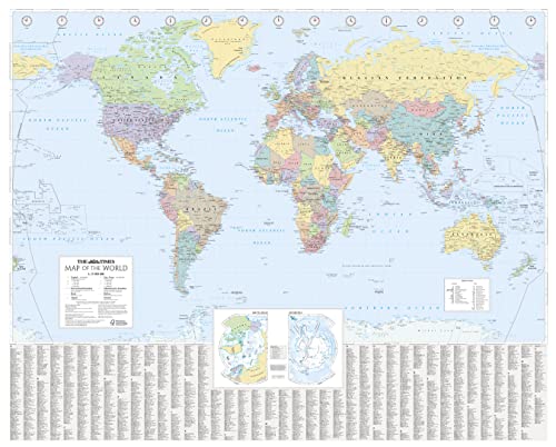

This laminated (front side only) Times Map of the World has been fully revised and updated to include the latest political changes. The map is politically coloured and shows individual countries and their capital city, major roads, railways and cities and towns.
Local name forms are used for all towns and cities with the English or historical alternative shown in brackets e.g. Mumbai (Bombay), Sankt Peterburg (Leningrad) where space permits. This makes the map readily accessible to the general reader who needs an up-to-date map to follow reports of world events in newspapers, on radio and television.
INCLUDES:
� All recent political changes carried out to mapping.
� Index to names on the map with cross references to alternative and historical name forms.
SIZE:
100 x 125 cm, 39.5 x 49 inches
AREA OF COVERAGE:
All of the world, centred on the Greenwich Meridian, and including maps of the North and South Pole regions.
SCALE:
Scale 1:25 000 000; 1 cm to 250 km; 1 inch to 395 miles.
Le informazioni nella sezione "Riassunto" possono far riferimento a edizioni diverse di questo titolo.
L'autore:
Collins UK is a leading information-led publisher of illustrated and narrative nonfiction.
Le informazioni nella sezione "Su questo libro" possono far riferimento a edizioni diverse di questo titolo.
- EditoreHarpercollins Pub Ltd
- Data di pubblicazione2014
- ISBN 10 0007493126
- ISBN 13 9780007493128
- RilegaturaPoster
- Numero di pagine1
(nessuna copia disponibile)
Cerca: Inserisci un desiderataSe non trovi il libro che cerchi su AbeBooks possiamo cercarlo per te automaticamente ad ogni aggiornamento del nostro sito. Se il libro � ancora reperibile da qualche parte, lo troveremo!
Inserisci un desiderata