Articoli correlati a Colchester and the Blackwater Area (Sheet 168)
Sinossi
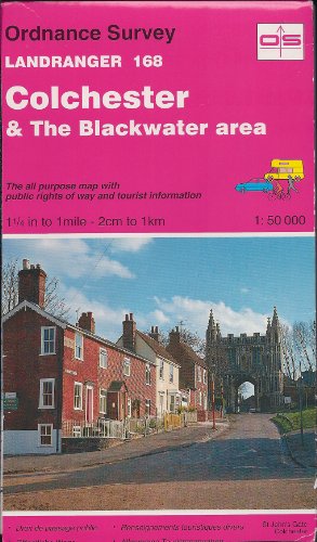
This map is part of the Landranger (Pink) series and is designed for people who really want to get to know an area. It includes the following information: tourist information, camping and caravan sites, picnic areas and viewpoints, selected places of interest and rights of way information for England and Wales. Each map in the series covers an area of 40 km by 40 km (25 miles by 25 miles) and like other Ordnance Survey maps, National Grid squares are provided so that any feature can be given a unique reference number. Perfect for planning ahead and local excursions, these maps are full of useful information that will help you really get to know an area.
Le informazioni nella sezione "Riassunto" possono far riferimento a edizioni diverse di questo titolo.
- EditoreOrdnance Survey
- Data di pubblicazione1992
- ISBN 10 0319221687
- ISBN 13 9780319221686
- RilegaturaMappa
Compra usato
Condizioni: discretoThis map is part of the Landranger... Scopri di pi� su questo articolo

EUR 3,56
Spese di spedizione:
EUR 5,72
Da: Regno Unito a: U.S.A.
I migliori risultati di ricerca su AbeBooks
Foto dell'editore
Colchester and the Blackwater Area (Sheet 168) (OS Landranger Map)
Editore:
Ordnance Survey, United Kingdom, Hants, 1992
ISBN 10: 0319221687
ISBN 13: 9780319221686
Antico o usato
Paperback
Da: WorldofBooks, Goring-By-Sea, WS, Regno Unito
Valutazione del venditore 5 su 5 stelle
![]()
Paperback. Condizione: Fair. This map is part of the Landranger (Pink) series and is designed for people who really want to get to know an area. It includes the following information: tourist information, camping and caravan sites, picnic areas and viewpoints, selected places of interest and rights of way information for England and Wales. Each map in the series covers an area of 40 km by 40 km (25 miles by 25 miles) and like other Ordnance Survey maps, National Grid squares are provided so that any feature can be given a unique reference number. Perfect for planning ahead and local excursions, these maps are full of useful information that will help you really get to know an area. A readable copy of the book which may include some defects such as highlighting and notes. Cover and pages may be creased and show discolouration. Codice articolo GOR001664917
Quantit�: 3 disponibili
Foto dell'editore
Colchester and the Blackwater Area (Sheet 168) (OS Landranger Map)
Editore:
Ordnance Survey, United Kingdom, Hants, 1992
ISBN 10: 0319221687
ISBN 13: 9780319221686
Antico o usato
Paperback
Da: WorldofBooks, Goring-By-Sea, WS, Regno Unito
Valutazione del venditore 5 su 5 stelle
![]()
Paperback. Condizione: Very Good. This map is part of the Landranger (Pink) series and is designed for people who really want to get to know an area. It includes the following information: tourist information, camping and caravan sites, picnic areas and viewpoints, selected places of interest and rights of way information for England and Wales. Each map in the series covers an area of 40 km by 40 km (25 miles by 25 miles) and like other Ordnance Survey maps, National Grid squares are provided so that any feature can be given a unique reference number. Perfect for planning ahead and local excursions, these maps are full of useful information that will help you really get to know an area. The book has been read, but is in excellent condition. Pages are intact and not marred by notes or highlighting. The spine remains undamaged. Codice articolo GOR001381153
Quantit�: 2 disponibili
Immagini fornite dal venditore
Colchester and the Blackwater Area (Sheet 168) (OS Landranger Map)
Da: WeBuyBooks, Rossendale, LANCS, Regno Unito
Valutazione del venditore 5 su 5 stelle
![]()
Condizione: LikeNew. Most items will be dispatched the same or the next working day. Codice articolo wbs5998518139
Quantit�: 1 disponibili
Immagini fornite dal venditore
Colchester and the Blackwater Area (Sheet 168) (OS Landranger Map)
Da: WeBuyBooks, Rossendale, LANCS, Regno Unito
Valutazione del venditore 5 su 5 stelle
![]()
Condizione: Good. Most items will be dispatched the same or the next working day. Codice articolo wbs2355350209
Quantit�: 1 disponibili
Foto dell'editore
Landranger Maps: Colchester and the Blackwater Area Sheet 168 (OS Landranger Map)
Da: Brit Books, Milton Keynes, Regno Unito
Valutazione del venditore 5 su 5 stelle
![]()
Map. Condizione: Used; Very Good. ***Simply Brit*** Welcome to our online used book store, where affordability meets great quality. Dive into a world of captivating reads without breaking the bank. We take pride in offering a wide selection of used books, from classics to hidden gems, ensuring there is something for every literary palate. All orders are shipped within 24 hours and our lightning fast-delivery within 48 hours coupled with our prompt customer service ensures a smooth journey from ordering to delivery. Discover the joy of reading with us, your trusted source for affordable books that do not compromise on quality. Codice articolo 3722265
Quantit�: 3 disponibili