Articoli correlati a Europe Executive: Wall Maps Continents
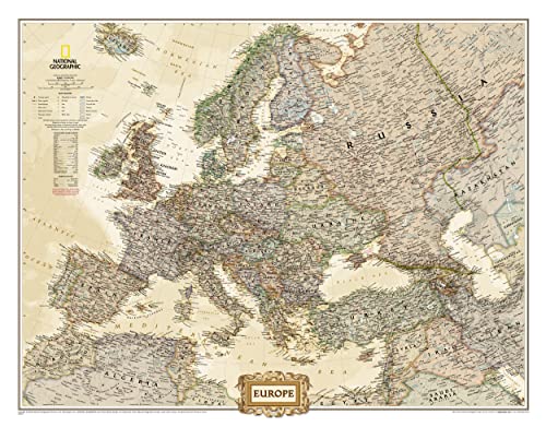

The Executive political map of Europe is a striking example of the cartographic excellence National Geographic is known for. The antique color palette, shaded relief, and easy-to-read fonts make this map both beautiful and functional. International boundaries are clearly defined and thousands of place names, waterbodies, airports, major highways and roads, national parks and more are included.
This map includes complete coverage of the countries and major cities of Albania, Armenia, Austria, Azerbaijan, Belarus, Belgium, Bosnia & Herzegovina, Bulgaria, Croatia, Cyprus, Czech Republic, Denmark, Estonia, Finland, France, Georgia, Germany, Greece, Hungary, Iceland, Ireland, Italy, Kosovo, Latvia, Liechtenstein, Lithuania, Luxembourg, Macedonia, Moldova, Montenegro, The Netherlands, Norway, Poland, Portugal, Romania, Russia, Serbia, Slovakia, Slovenia, Spain, Sweden, Switzerland, Turkey, Ukraine, and the United Kingdom.
The map is packaged in a two inch diamater clear plastic tube. The tube has a decorative label showing a thumbnail of the map with dimensions and other pertinent information.
- Map Scale = 1:8,400,000
- Sheet Size = 30.5" x 23.75"
Le informazioni nella sezione "Riassunto" possono far riferimento a edizioni diverse di questo titolo.
- EditoreNatl Geographic Society Maps
- Data di pubblicazione2012
- ISBN 10 0792289838
- ISBN 13 9780792289838
- RilegaturaMappa
- Numero di pagine1
Compra nuovo
Scopri di pi� su questo articolo
EUR 115,05
Spese di spedizione:
EUR 28,97
Da: Regno Unito a: U.S.A.
I migliori risultati di ricerca su AbeBooks
Immagini fornite dal venditore
Europe Executive, Tubed
Editore:
National Geographic Maps Aug 2012
(2019)
ISBN 10: 0792289838
ISBN 13: 9780792289838
Nuovo
Quantit�: 1
Da:
Valutazione libreria
Descrizione libro Condizione: new. Book is in NEW condition. Satisfaction Guaranteed! Fast Customer Service!!. Codice articolo PSN0792289838
Compra nuovo
EUR 115,05
Convertire valuta