Articoli correlati a Canterbury 1906: Kent Sheet 46.03

- EditoreAlan Godfrey Maps
- Data di pubblicazione2010
- ISBN 10 1847843980
- ISBN 13 9781847843982
- RilegaturaMappa
Compra nuovo
Scopri di pi� su questo articolo
EUR 3,30
Spese di spedizione:
EUR 35,46
Da: Regno Unito a: U.S.A.
I migliori risultati di ricerca su AbeBooks
Foto dell'editore
Canterbury 1906: Kent Sheet 46.03 (Old Ordnance Survey Maps of Kent)
Da:
Valutazione libreria
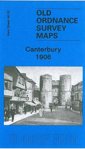
Descrizione libro No Binding. Condizione: New. No Jacket. Here are the details of maps for Canterbury: Kent Sheet 46.03 Canterbury 1906 - published 2010; intro by Barrie Trinder. ISBN.978-1-84784-398-2 This detailed and busy map covers most of central Canterbury, with coverage stretching from the Cemetery and London Road eastward to Longport Street and the Barracks, and from Hanover Road southward to Gordon Road. Features include city centre with individual buildings neatly shown, Cathedral, both railway stations with approaches, Harbledown Junction, Danejohn Mound, City Wall, St Gregory's church, St Mildred's church, remains of St Augustine's Abbey, Missionary College, Infantry Barracks, Artillery Barracks, Holy Cross church, St Dunstan's church, brewery, St Peter's church, Dean's Mill, Agricultural Hall, St Mildred's Tannery, Simon Langton Schools, Ersham House, Kent & Canterbury Hospital, St George the Martyr's church, etc. On the reverse we include a directory of city and cathedral officials. Codice articolo 005380
Compra nuovo
EUR 3,30
Convertire valuta