Riguardo questo articolo
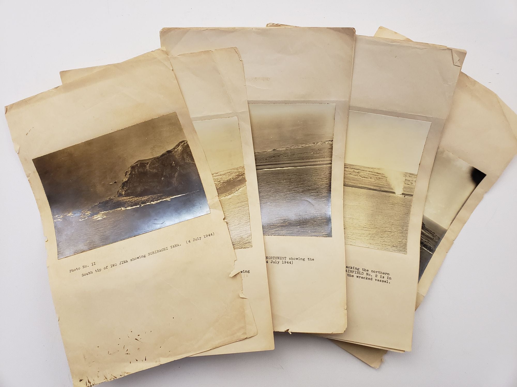
Archive of Fifteen original WWII photographs of Iwo Jima Reconaissance Missions for the US Military. Date July 4, 1944. Images mounted on paper with typed descriptions, set includes Photo No. II - XVI (missing photo I). Photos measure 5 x 7" to 6 x 7", all mounted onto 8 x 13" paper to be part of military report in preparation for the battle. The report also notes various defensive attributes and landmarks on the island, such the "eastern boat basin," Chidoriga Hara, Suribachi Yama, Moto Yama, radio stations, entrenchments, a taxiway, and an RDF (Radio Direction Finding) tower. Also notes aspects of the landscape in the photos to consider for battle planning, such as "steep terraces," "rugged interior," and "steep cliffs." Iwo Jima was the at the center of conflict in the Pacific theater of WWII; it was an important midway point between Tokyo and the US airbase on the Mariana Islands, and was the setting for one of the bloodiest battles in the Pacific when US Marines invaded on February 19, 1945 (subsequently known as the Battle of Iwo Jima). These photos were taken on July 4, 1944 -- 7 months before this historic battle began. The American invasion (Operation Detachment) had the purpose of capturing the island with its two airfields: South Field and Central Field, also known as Motoyama Airfield No. 1 and Motoyama Airfield No. 2; report includes images of these airfields. The airfields were considered important military resources, as they provided a place at the midpoint between Tokyo and the US airbase on the Mariana Islands, where damaged Allied planes could land; it could also provide airfields for long-range P-51s which provided fighter coverage to the bombers. Notably, this report fails to mention the possibility for any type of tunnel, bunker, or underground fortifications; it is clear evidence of the way in which Allied forces misjudged and underestimated Japanese defensive strategies, leading the Battle of Iwo Jima to be one of the bloodiest conflicts in the Pacific. Starting on 15 June 1944, the U.S. Navy and the U.S. Army Air Forces began naval bombardments and air raids against Iwo Jima. These photos were taken just over two weeks after the initial bombing campaign began; and they clearly show that the US military was gaining reconnaissance on beaches, coastline, and areas where they had encountered fierce Japanese resistance in other battles. The images were likely taken by members of a US Navy Task Force with aircraft assigned to sweep the island and destroy defenses. Images depict Motoyama Airfield with smoke issuing from the area, a wrecked vessel in the "eastern boat basin," and the rugged landscape of the island from the southern to northeastern tip. The report notes various defensive attributes and landmarks on the island, such Chidoriga Hara, Suribachi Yama, Moto Yama, radio stations, entrenchments, a taxiway, and an RDF (Radio Direction Finding) tower. Also notes aspects of the landscape to consider for battle planning such as "steep terraces," "rugged interior," and "steep cliffs." At this time and in anticipation of a US invasion, Japanese forces were preparing an unusual defense that broke with established Japanese military doctrine -- rather than defending the beaches, Japanese Lt. Gen. Kuribayashi devised a plan to create an intricate system of underground tunnels and fortifications. Kuribayashi was ordered by Tojo to resist to the last man on Iwo Jima in order to gain time necessary for the preparation of the Japanese Homeland defenses. In July and August of 1944, thousands of Japanese soldiers were arriving on the island to support the defensive strategies of building tunnels and underground fortifications-with a dense network of bunkers, hidden artillery positions, and 11 miles of tunnels. This report fails to mention the possibility for any type of tunnel, bunker, or underground fortifications. This is clear evidence of the way in which Allied forces misjudged and underestimated Japanese defensive. Codice articolo 17083
Contatta il venditore
Segnala questo articolo


