Al contenuto principale
abebooks.it
Cerca
Login
Mio Account
Carrello
Aiuto
Menu
Mio Account
Tracciare ordini
Ricerca Avanzata
Collezioni
Libri antichi e rari
Arte e Collezionismo
Venditori
Vendere con noi
Aiuto
Chiudere
Africa Regions Maps
Di
Garwood & Voigt
Più popolari
Aggiunti di recente
Prezzo crescente
SOUTH AFRICA. Detailed map of southern Africa, showing Cape Colony, Orange River Free State, Tr...
Edward Stanford.
INSULAE DE CABO VERDE OLIM HESPERIDES SIVE GORGADES.. Sea chart of the Cape Verde Islands with ...
Janssonius, J. / Schenk, P. & Valk, G.
THE DIAMOND DIGGINGS, SOUTH AFRICA. Many labourers and supervisors going about their work aroun...
Anonymous.
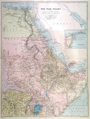
THE NILE VALLEY. Large map of Egypt and the Nile, Nubia, Uganda, Abyssinia, Congo Free State, D...
Edward Stanford.
STÜCK VON DER KÜSTE VON GUINEA VON DEM FLUSSE SIERRA LEONE BIS AN DAS VORGEBIRGE PALMA. West Af...
Bellin, N.
MR H. M. STANLEY S EXPLORATIONS IN THE DARK CONTINENT - MAP OF THE ROUTE AND A PORTRAIT GROUP OF...
Johnston, A. K.
CHARTE VON SENEGAMBIEN, NIGRITIEN UND GUINEA.. Map of the African west coast with the Gulf of G...
Reinecke, J. C. M.
CHARTE VON NIEDER GUINEA UND DEN ANGRENZENDEN LÄNDERN SÜD-AFRICAS.. Map of the African southwes...
Reinecke, J. C. M.
EGYPT.
Hall, S.
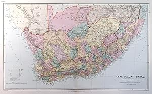
'SOUTH AFRICA'. Map of South Africa with inset maps of Capetown, the environs of Capetown, Distri...
Walker, J. & C.
SOUTHERN AFRICA.
Hall, S.
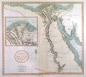
EGYPT. Detailed doublepage map of Lower, Central and Upper Egypt.
Lizars, W.
WESTERN AFRICA. Western Africa between Senegal and Congo.
Hall, S.
ROYAUME DE MAROC DIVISÉ EN SEPT PROVINCES. Map of southern Morocco.
Sanson, N.
GUINEE. Map of West Africa between Senegal and Congo.
Du Val, P.
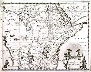
'AETHIOPIA SUPERIOR VEL INTERIOR VULGO ABISSINORUM SIVE PRESBITERIIOANNIS IMPERIUM'. Map of Centr...
Merian, Matthaeus.
'AETHIOPIA INFERIOR VEL EXTERIOR MONOMOTAPA'. Map of South Africa with large figurative cartouche...
Merian, Matthaeus.
CAIRO TO KHARTOUM. Long detailed panorama of the River Nile from Cairo to Khartoum. Two views a...
The Graphic.
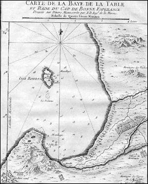
CARTE DE LA BAYE DE LA TABLE ET RADE DU CAP DE BONNE ESPERANCE. Map of the Table Bay.
Bellin, N.
KARTE VON DER KÜSTE UND DEN BENACHBARTEN LAENDERN DER FLÜSSE SIERRA LEONA UND SHERBRO. Sierra L...
Bellin, N.
WYLDS EGYPT SOUDAN AND THE RED SEA. Map of Egypt and the Nile from source to sea, Nubia, the R...
Wyld, James.
CAIRO TO KHARTOUM. Long detailed panorama of the River Nile from Cairo to Khartoum. Two views a...
The Graphic.
CAPE COLONY, NATAL, AND THE ORANGE RIVER COLONY. A superb detailed map of the Cape Colony at th...
Edward Stanford.
KARTE VON DER KÜSTE VON ANGOLA.. Map of the immediate area around Luanda, the capiatl of Angola.
Bellin, N.
SPORT IN SOUTH AFRICA. Eight scenes of wild game hunting. Lions, Tigers, Crocodiles, Antelopes,...
Baden-Powell, Capt. R.S.S.
'NORTHERN AFRICA'.
Tallis, J.
CENTRAL AFRICA. Map of Central Africa: 34 English miles to the inch. Railways and railways prop...
Edward Stanford.
MADAGASCAR. A large detailed map.
Edward Stanford.
CAPE COLONY, NATAL AND THE ORANGE RIVER COLONY.
Edward Stanford.
GUINEA. Decorative map of the western coast of Africa from Guinea to Nigeria. Published by Piet...
Janssonius, J. / Schenk, P. & Valk, G.
CHARTE DER SÜDSPITZE AFRICAS UND DER COLONIE VOM VORGEBIRGE DER GUTEN HOFFNUNG.. Map of South A...
Reinecke, J. C. M.
A NEW MAP OF EGYPT.. Map of Egypt, reaching south to Assuan, with large inset map of the Nile d...
Cary, J.
CHARTE DER NORDKÜSTE AFRICAS ODER DIE STAATEN MAROCCOS, FES, ALGIER, TUNIS, TRIPOLI, UND AEGYPTE...
Reinecke, J. C. M.
CAPE TOWN, CAPE OF GOOD HOPE, RECENTLY VISITED BY HIS ROYAL HIGHNESS THE DUKE OF EDINBURGH. Sup...
Anonymous.
ILE MAURICE NOMMÉE DEPUIS ILE DE FRANCE. View of the bay and harbour and mountainous coastline ...
Bellin, N.
'NEUESTE KARTE VON SÜDAFRICA'. Map of South Africa with inset maps of the wider areas around Cape...
Meyer, J.
GRUNDRISS VON DEM FORT DAUPHIN.. Plan of the French settlement of Tolanaro on the southern Mada...
Bellin, N. / Schley, J. v.
KARTE VON DEM EYLANDE MONBASA AN DER OSTLICHEN KÜSTE VON AFRICA. Map of the island and town of ...
Bellin, N.
KARTE VON DEM FLUSSE GAMBRA ODER GAMBIA VON DESSEN MÜNDUNG BIS NACH EROPINA. and .VON EROPINA ...
Bellin, N. / Leach, J.
RADE DEA CASABLANCA and APPROACHES TO CASABLANCA AND FEDALA [corrected to: MOHAMMEDIA]. Two d...
Admiralty Charts.
THE GRAPHIC STANLEY NUMBER. Complete 36-page supplement of Stanley in Africa, with three extra ...
Johnston, A. K.
A SIKH SENTRY AT FORT JOHNSTON, BRITISH CENTRAL AFRICA . Full length portrait of a sentry on duty...
Johnston, H. H.
THE CRISIS IN EGYPT - PANORAMIC VIEW OF CAIRO . A superb prospect of Cairo with the Mosque of the...
Brewer, J. W.
BIRDS EYE VIEW OF CAIRO LOOKING NORTH EAST. The pyramids and Sphinx in the foreground. Special ...
The Graphic.
WEST AFRICA SHOWING THE BRITISH POSSESSIONS. A very detailed map, 94 English miles to the inch....
Edward Stanford.
BACONS BIRDS-EYE VIEW OF SOUTH AFRICA. Large map of South Africa, with inset map of North Nata...
Bacon, G. W.
A BIRDS EYE VIEW OF THE SUEZ CANAL. Looking west, Cairo in the background. Special chromolithog...
The Graphic.
KARTE VON DEN EYLANDEN DES GRÜNEN VORGEBÜRGES. Map of the Cape Verde Islands.
Bellin, N.
PARTIE DE BARBARIE, OU EST LE ROYAUME DALGER.. Map of Algeria.
Sanson, N.
NIGRITIE. Map of West Africa between Mauretania and Cameroon.
Du Val, P.
ISLES DU CAP VERD. Small map of the Cape Verde Islands.
Du Val, P.
CARTE DE LA RIVIERE DE GAMBRA OU GAMBIE DEPUIS SON EMBOUCHURE JUSQUA EROPINA and .DEPUIS EROP...
Bellin, N. / Leach, J.
DAS REICH MONOMOTAPA UND DESSEN BENACHBARTE STAATEN. Map of Zimbabwe and Mozambique between the...
Bellin, N.
EYLAND MADAGASCAR SONST INSEL ST LAURENTIUS. Map of the Island of Madagascar.
Bellin, N.
FEZZAE ET MAROCCHI REGNA AFRICAE CELEBERRIMA. Map of Morocco with figurative title cartouche an...
Merian, Matthaeus.
ALGIER. Half birds-eye plan / view of Algiers with fortifications and harbour. Engraved by Meri...
Merian, Matthaeus.
Carica altri


![RADE DEA CASABLANCA and APPROACHES TO CASABLANCA AND FEDALA [corrected to: MOHAMMEDIA]. Two d...](http://pictures.abebooks.com/inventory/md/md30455956761.jpg)


