Importo totale (1 articolo articoli):
Destinazione ordine:

ANVILLE, JEAN BAPTISTE B D' (8 risultati)
Vai alla pagina principale dei risultati di ricerca
Tipo di articolo
- Tutti gli articoli
- Libri (1)
- Riviste e Giornali
- Fumetti
- Spartiti
- Arte, Stampe e Poster
- Fotografie
- Mappe (7)
-
Manoscritti e
Collezionismo cartaceo
Condizioni
Legatura
- Tutte
- Rilegato (1)
- Brossura
Ulteriori caratteristiche
- Prima edizione
- Copia autografata
- Sovraccoperta
- Con foto
- No print on demand (7)
Spedizione gratuita
Paese del venditore
Valutazione venditore
-
![Immagine del venditore per Nouvel atlas de la Chine, de la Tartarie chinoise et du Thibet : contenant les cartes generales & particulieres de ces pays, ainsi que la carte du royaume de Coree : la plupart levees sur les lieux par ordre de l'empereur Cang-Hi avec toute l'exactitude imaginable, soit par les PP. Jesuites missionaires a la Chine, soit par des Tartares du Tribunal des mathematiques, & toutes revues par les memes peres (1737) [LeatherBound] venduto da True World of Books](https://pictures.abebooks.com/inventory/md/md31657373286.jpg)
Nouvel atlas de la Chine, de la Tartarie chinoise et du Thibet : contenant les cartes generales & particulieres de ces pays, ainsi que la carte du royaume de Coree : la plupart levees sur les lieux par ordre de l'empereur Cang-Hi avec toute l'exactitude imaginable, soit par les PP. Jesuites missionaires a la Chine, soit par des Tartares du Tribunal des mathematiques, & toutes revues par les memes peres (1737) [LeatherBound]
Data di pubblicazione: 2023
Libro Print on Demand
LeatherBound. Condizione: New. LeatherBound edition. Condition: New. Reprinted from 1737 edition. Leather Binding on Spine and Corners with Golden leaf printing on spine. Bound in genuine leather with Satin ribbon page markers and Spine with raised gilt bands. A perfect gift for your loved ones. NO changes have been made to the original text. This is NOT a retyped or an ocr'd reprint. Illustrations, Index, if any, are included in black and white. Each page is checked manually before printing. As this print on demand book is reprinted from a very old book, there could be some missing or flawed pages, but we always try to make the book as complete as possible. Fold-outs, if any, are not part of the book. If the original book was published in multiple volumes then this reprint is of only one volume, not the whole set. Sewing binding for longer life, where the book block is actually sewn (smythe sewn/section sewn) with thread before binding which results in a more durable type of binding. Pages: 117 Anville, Jean Baptiste Bourguignon d', 1697-1782,Rockhill, William Woodville, 1854-1914 former owner. MChB-B.
-
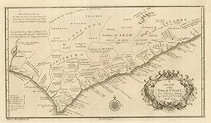
A map of the Gold Coast from Issini to Alampi by M. d'Anville.
Data di pubblicazione: 1772
Da: Altea Antique Maps, London, Regno Unito
Membro dell'associazione: ABA ILAB PBFA
Valutazione venditore:

Mappa
London, 1729. 200 x 345mm. Map of the Gold Coast of Africa after D'Anville, engraved by George Child. In the top left corner the text reads: ''Advertisement - this map has been somewhat improved & corrected, as well as ye names of places accomodated to the English orthography''.
-
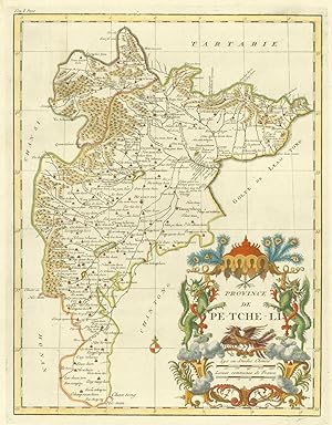
Province de Pe-tche-li.
Data di pubblicazione: 1735
Da: Altea Antique Maps, London, Regno Unito
Membro dell'associazione: ABA ILAB PBFA
Valutazione venditore:
Mappa
Paris, c.1735. 395 x 320mm. The province of Beizhili, the region around Beijing ( Peking ), showing the Great Wall, with a very decorative chinoiserie title cartouche depicting dragons. D'Anville's atlas of China was the first western atlas of China since Blaeu in 1654.
-
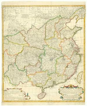
Carte Generale de la Chine Dressée sur les Cartes Particulieresque l'Empereur Cang-Hi a fait lever sur les Lieux R.R.P.P. Jésuites Missionaires dans cet Empire.
Data di pubblicazione: 1737
Da: Altea Antique Maps, London, Regno Unito
Membro dell'associazione: ABA ILAB PBFA
Valutazione venditore:
Mappa
Paris, 1737. Original colour with later additions. 620 x 520mm. Some restoration. Narrow left and right margins. One of the general maps of China from D'Anville's 'Nouvelle Atlas de Chine', the most important set of maps of China since the Blaeu/Martini atlas. With two chinoiserie cartouches.
-
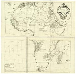
Afrique Publiée sous les Auspices de Monsieur Le Duc d'Orleans Prémier Prince du Sang.
Data di pubblicazione: 1780
Da: Altea Antique Maps, London, Regno Unito
Membro dell'associazione: ABA ILAB PBFA
Valutazione venditore:
Mappa
Venice: Guiseppi Antonio Remondini, c.1780. Original outline colour. 4 sheets joined in pairs, sections 465 x 970mm & 505 x 970mm, total if joined c.990 x 970mm. A large map of Africa, detailed around the coasts but still showing the classical 'Mountains of the Moon' in the interior. The map is decorated with an allegorical figure of the continent wearing an elephant headdress and holding a lobster, another for the Nile, and a crocodile, camel, lion, a bird and a sphinx. From Paolo Santini's 'Atlas Universel', which was published from 1776 to 1784.
-
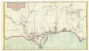
Carte de la Louisiane. Par le Sr. d'Anville. Dressée en Mai 1732. Publiee en 1752.
Data di pubblicazione: 1752
Da: Altea Antique Maps, London, Regno Unito
Membro dell'associazione: ABA ILAB PBFA
Valutazione venditore:
Mappa
Paris, 1752. Coloured. Two sheets conjoined, total 515 x 920mm. A detailed map of the Louisiana coastline from near Panama City west to 'Adayes' or Los Adaes, until 1770 the capital city of the Spanish province of Texas. It is based on the manuscript maps by Valentin Devin, who surveyed the area in 1719 for John Law's 'Compagnie d'Occident', which created the infamous 'Mississippi Bubble', which crashed France's economy in 1720. The map concentrates on the rivers, including the Mississippi with an inset of the Missouri up into Illinois. Engraved by Guillaume De la Haye.
-
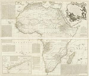
Africa, According to Mr. D'Anville with Several Additions, & Improvements, with a Particular Chart of the Gold Coast; wherein are distinguished all the European Forts and Factories, The whole Illustrated With a Summary Description Relative to the Trade & Natural-Produce, Manners & Customs of that Part of the World.
Data di pubblicazione: 1772
Da: Altea Antique Maps, London, Regno Unito
Membro dell'associazione: ABA ILAB PBFA
Valutazione venditore:
Mappa
London: Robert Sayer, 1772. Original outline colour. Four sheets conjoined, total 1045 x 1250mm. A very fine example of a large and detailed map of Africa (on the coasts at least), with a huge title cartouche of natives killing and earing their enemies. Extensive text boxes describe the trading opprtunities of each region. The text in the inset of the Gold Coast is devoted to gold rather than the other main export of the area, slaves. See NORWICH: 105 for a later state, erroneously described as two-sheet.
-
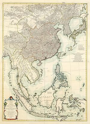
Seconde Partie de la Carte d'Asie, contenant La Chine et partie de la Tartarie, L'Inde au de la du Gange, Les Isles Sumatra, Java, Borneo, Moluques, Philippines, et du Japon.
Data di pubblicazione: 1752
Da: Altea Antique Maps, London, Regno Unito
Membro dell'associazione: ABA ILAB PBFA
Valutazione venditore:
Mappa
Paris, 1752. Original colour with additions on the cartouche. Two sheets conjoined, total 980 x 695mm. A large map of eastern Asia, engraved by Guillaume de la Haye. It shows from Burma east to Japan and south to Java and Timor. Vietnam, China, Korea, the Philippines and Japan are shown in the best detail, although Hokkaido is shown as the vague 'Jesso'. The Malay Peninsula. Cambodia, Sumatra, Borneo, Celebes and western New Guinea are also shown, but with less information in their interiors.