Importo totale (1 articolo articoli):
Destinazione ordine:

ARROWSMITH, AARON (275 risultati)
Vai alla pagina principale dei risultati di ricerca
Tipo di articolo
- Tutti gli articoli
- Libri (153)
- Riviste e Giornali
- Fumetti
- Spartiti
- Arte, Stampe e Poster (2)
- Fotografie
- Mappe (120)
-
Manoscritti e
Collezionismo cartaceo
Condizioni
Legatura
Ulteriori caratteristiche
Spedizione gratuita
Paese del venditore
Valutazione venditore
-
![Immagine del venditore per Index to the Eton comparative atlas of ancient and modern geography [Soft Cover ] venduto da booksXpress](https://pictures.abebooks.com/inventory/md/md31452228015.jpg)
Index to the Eton comparative atlas of ancient and modern geography [Soft Cover ]
Editore: Alpha Editions, 2020
ISBN 10: 9354022790ISBN 13: 9789354022791
Libro
Soft Cover. Condizione: new.
Ulteriori offerte da altri venditori AbeBooks
Nuovo - A partire da EUR 9,40
-
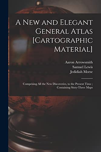
A New and Elegant General Atlas [cartographic Material] : Comprising All the New Discoveries, to the Present Time ; Containing Sixty-three Maps
Editore: Legare Street Press, 2021
ISBN 10: 1014804329ISBN 13: 9781014804327
Libro
Condizione: As New. Unread book in perfect condition.
Ulteriori offerte da altri venditori AbeBooks
Nuovo - A partire da EUR 17,35
Usato - A partire da EUR 16,72
Scopri anche Brossura
-
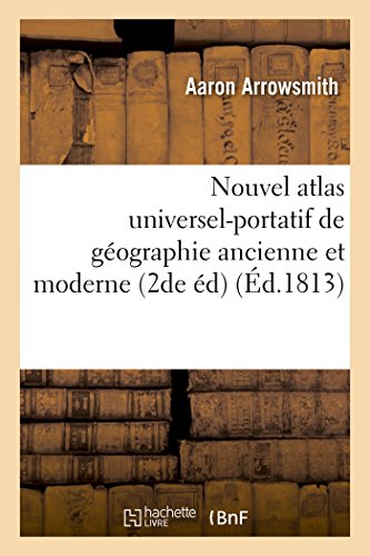
Nouvel Atlas Universel-Portatif de Géographie Ancienne Et Moderne. Seconde Édition (Histoire) (French Edition)
Editore: Hachette Livre Bnf, 2016
ISBN 10: 201954234XISBN 13: 9782019542344
Libro
Condizione: New.
Ulteriori offerte da altri venditori AbeBooks
Nuovo - A partire da EUR 16,15
-

Germany N.W. Part (1817)
Editore: A Constable, 1817
Da: Waimakariri Books and Prints Limited, Oxford, Nuova Zelanda
Valutazione venditore:

Mappa
No Binding. Condizione: Very Good. Uncoloured map of North-Western Germany by Sidney Hall and Aaron Arrowsmith, published in Edinburgh in 1817 by A Constable and Co. Image area 200 x 250mm approx, good margins, light marking to the margins, a few spots of foxing to the image area. Free standard airmail worldwide.
-
Germany S.E. Part (1817)
Editore: A Constable, 1817
Da: Waimakariri Books and Prints Limited, Oxford, Nuova Zelanda
Valutazione venditore:
Mappa
No Binding. Condizione: Very Good. Uncoloured map of South-Eastern Germany by Sidney Hall and Aaron Arrowsmith, published in Edinburgh in 1817 by A Constable and Co. Image area 200 x 250mm approx, good margins, light marking to the margins, a few spots of foxing to the image area. Free standard airmail worldwide.
-
Germany S.W. Part (1817)
Editore: A Constable, 1817
Da: Waimakariri Books and Prints Limited, Oxford, Nuova Zelanda
Valutazione venditore:
Mappa
No Binding. Condizione: Very Good. Uncoloured map of South-Western Germany by Sidney Hall and Aaron Arrowsmith, published in Edinburgh in 1817 by A Constable and Co. Image area 200 x 250mm approx, good margins, light marking to the margins, a few spots of foxing to the image area. Free standard airmail worldwide.
-

Cary's Actual Survey, Of The Great Post Roads Between London And Falmouth
Editore: Legare Street Press, 2023
ISBN 10: 1022569864ISBN 13: 9781022569867
Libro Print on Demand
PAP. Condizione: New. New Book. Shipped from UK. THIS BOOK IS PRINTED ON DEMAND. Established seller since 2000.
Ulteriori offerte da altri venditori AbeBooks
Nuovo - A partire da EUR 21,19
-
A Geographical Dictionary of the Holy Scriptures
Editore: Forgotten Books, 2018
ISBN 10: 1333869940ISBN 13: 9781333869946
Libro
PAP. Condizione: New. New Book. Shipped from UK. Established seller since 2000.
Ulteriori offerte da altri venditori AbeBooks
Nuovo - A partire da EUR 21,53
Usato - A partire da EUR 13,19
Scopri anche Brossura
-

Condizione: Good. France by Arrowsmith & Lewis 1812 old antique vintage map plan chart. Antique steel engraved map; Arrowsmith, Aaron & Lewis, Samuel (1812). 25.0 x 20.0cm, 9.75 x 8 inches. Condition: Good. There is nothing printed on the reverse side, which is plain.
-
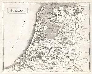
Condizione: Good. Holland by Arrowsmith & Lewis. Netherlands 1812 old antique map plan chart. Antique steel engraved map; Arrowsmith, Aaron & Lewis, Samuel (1812). 25.0 x 20.0cm, 9.75 x 8 inches. Condition: Good. There is nothing printed on the reverse side, which is plain.
-

Condizione: Good. Netherlands by Arrowsmith & Lewis 1812 old antique vintage map plan chart. Antique steel engraved map; Arrowsmith, Aaron & Lewis, Samuel (1812). 25.0 x 20.0cm, 9.75 x 8 inches. Condition: Good. There is nothing printed on the reverse side, which is plain.
-
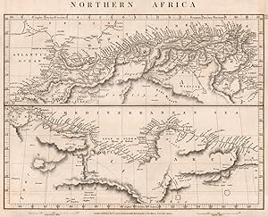
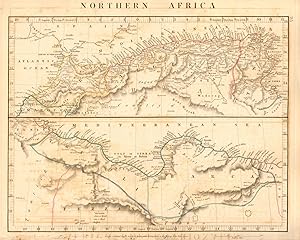
Condizione: Good. NORTHERN AFRICA.Maghreb.Marocco Algiers Tunis Tripoli Barca.ARROWSMITH 1828 map. Antique copperplate map; A. Arrowsmith (1828). 26.0 x 32.0cm, 10.25 x 12.75 inches. Condition: Good. The image shown may have been taken from a different example of this map than that which is offered for sale. The map you will receive is in good condition but there may be minor variations in the condition from that shown in the image. There is nothing printed on the reverse side, which is plain.
-
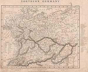
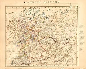
Condizione: Good. NORTHERN GERMANY. States. Free Cities. Switzerland Austria. ARROWSMITH 1828 map. Antique copperplate map; A. Arrowsmith (1828). 25.5 x 31.0cm, 10 x 12.25 inches. Condition: Good. The image shown may have been taken from a different example of this map than that which is offered for sale. The map you will receive is in good condition but there may be minor variations in the condition from that shown in the image. There is nothing printed on the reverse side, which is plain.
-
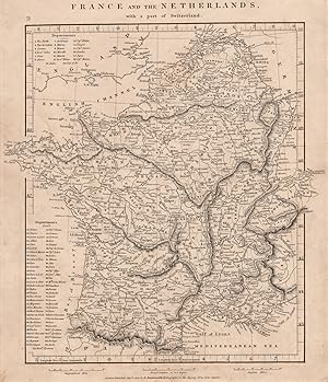
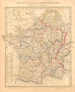
Condizione: Good. FRANCE & BENELUX. Netherlands, with a part of Switzerland. ARROWSMITH 1828 map. Antique copperplate map; A. Arrowsmith (1828). 31.0 x 26.5cm, 12.25 x 10.5 inches. Condition: Good. The image shown may have been taken from a different example of this map than that which is offered for sale. The map you will receive is in good condition but there may be minor variations in the condition from that shown in the image. There is nothing printed on the reverse side, which is plain.
-
Condizione: Good. NORTHERN AFRICA Maghreb Morocco Algiers Tunis Tripoli Barca. ARROWSMITH 1828 map. Antique copperplate map with original outline colour; A. Arrowsmith (1828). 26.0 x 32.0cm, 10.25 x 12.75 inches. Condition: Good. Tight bottom margin below caption; Minor offsetting -text and/or images from the facing page have left an impression on the print. Glue deposit to bottom margin. There is nothing printed on the reverse side, which is plain.
-
Condizione: Good. FRANCE & the Netherlands with a part of Switzerland. Benelux ARROWSMITH 1828 map. Antique copperplate map with original outline colour; A. Arrowsmith (1828). 31.0 x 26.5cm, 12.25 x 10.5 inches. Condition: Good. Minor offsetting -text and/or images from the facing page have left an impression on the print. There is nothing printed on the reverse side, which is plain.
-
Condizione: Good. NORTHERN GERMANY. States. Switzerland Austria Czechia. ARROWSMITH 1828 old map. Antique copperplate map with original outline colour; A. Arrowsmith (1828). 25.5 x 31.0cm, 10 x 12.25 inches. Condition: Good. Tight bottom margin below caption; Minor offsetting -text and/or images from the facing page have left an impression on the print. Damage to bottom margin, repaired. There is nothing printed on the reverse side, which is plain.
-
Denmark Sweden and Norway (1817)
Editore: A Constable, 1885
Da: Waimakariri Books and Prints Limited, Oxford, Nuova Zelanda
Valutazione venditore:
Mappa
No Binding. Condizione: Very Good. Map of Denmark, Sweden and Norway by Sidney Hall and Aaron Arrowsmith, published by A Constable in Edinburgh in 1817. Image area 203 x 248 mm approx, good margins, image clear and crisp, minor surface marks and foxing Free standard airmail worldwide.
-
A Compendium of Ancient and Modern Geography: For the Use of Eton School
Editore: Forgotten Books, 2018
ISBN 10: 0282862900ISBN 13: 9780282862909
Libro Print on Demand
Paperback. Condizione: New. Print on Demand. Excerpt from A Compendium of Ancient and Modern Geography. About the Publisher, Forgotten Books publishes hundreds of thousands of rare and classic books. This book is a reproduction of an important historical work. Forgotten Books uses state-of-the-art technology to digitally reconstruct the work, preserving the original format whilst repairing imperfections present in the aged copy. In rare cases, an imperfection in the original, such as a blemish or missing page, may be replicated in our edition. We do, however, repair the vast majority of imperfections successfully; any imperfections that remain are intentionally left to preserve the state of such historical works. This text has been digitally restored from a historical edition. Some errors may persist, however we consider it worth publishing due to the work's historical value. The digital edition of all books may be viewed on our website before purchase. print-on-demand item.
Ulteriori offerte da altri venditori AbeBooks
Nuovo - A partire da EUR 24,87
-
A Compendium of Ancient and Modern Geography: For the Use of Eton School
Editore: Forgotten Books, 2018
ISBN 10: 152761428XISBN 13: 9781527614284
Libro Print on Demand
Paperback. Condizione: New. Print on Demand. Excerpt from A Compendium of Ancient and Modern Geography. About the Publisher, Forgotten Books publishes hundreds of thousands of rare and classic books. This book is a reproduction of an important historical work. Forgotten Books uses state-of-the-art technology to digitally reconstruct the work, preserving the original format whilst repairing imperfections present in the aged copy. In rare cases, an imperfection in the original, such as a blemish or missing page, may be replicated in our edition. We do, however, repair the vast majority of imperfections successfully; any imperfections that remain are intentionally left to preserve the state of such historical works. This text has been digitally restored from a historical edition. Some errors may persist, however we consider it worth publishing due to the work's historical value. The digital edition of all books may be viewed on our website before purchase. print-on-demand item.
Ulteriori offerte da altri venditori AbeBooks
Nuovo - A partire da EUR 25,51
-
![Immagine del venditore per Complete Neptune, to illustrate . the progres of maritime discovery 1803 [LeatherBound] venduto da True World of Books](https://pictures.abebooks.com/inventory/md/md31617617636.jpg)
Complete Neptune, to illustrate . the progres of maritime discovery 1803 [LeatherBound]
Data di pubblicazione: 2023
Libro Print on Demand
LeatherBound. Condizione: New. LeatherBound edition. Condition: New. Reprinted from edition. Leather Binding on Spine and Corners with Golden leaf printing on spine. Bound in genuine leather with Satin ribbon page markers and Spine with raised gilt bands. A perfect gift for your loved ones. NO changes have been made to the original text. This is NOT a retyped or an ocr'd reprint. Illustrations, Index, if any, are included in black and white. Each page is checked manually before printing. As this print on demand book is reprinted from a very old book, there could be some missing or flawed pages, but we always try to make the book as complete as possible. Fold-outs, if any, are not part of the book. If the original book was published in multiple volumes then this reprint is of only one volume, not the whole set. Sewing binding for longer life, where the book block is actually sewn (smythe sewn/section sewn) with thread before binding which results in a more durable type of binding. Pages: 25.
-
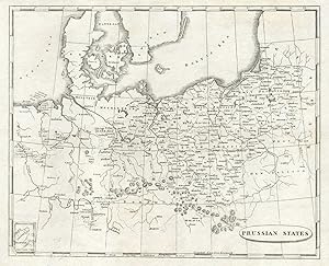
Condizione: Good. Prussian States by Arrowsmith & Lewis. Poland 1812 old antique map plan chart. Antique steel engraved map; Arrowsmith, Aaron & Lewis, Samuel (1812). 25.0 x 20.0cm, 9.75 x 8 inches. Condition: Good. There is nothing printed on the reverse side, which is plain.
-
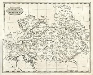
Condizione: Good. Austrian Dominions. Arrowsmith & Lewis. Hungary Czechia Slovakia Veneto 1812 map. Antique steel engraved map; Arrowsmith, Aaron & Lewis, Samuel (1812). 25.0 x 20.0cm, 9.75 x 8 inches. Condition: Good. There is nothing printed on the reverse side, which is plain.
-
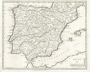
Condizione: Good. Spain and Portugal by Arrowsmith & Lewis. Iberia 1812 old antique map chart. Antique steel engraved map; Arrowsmith, Aaron & Lewis, Samuel (1812). 25.0 x 20.0cm, 9.75 x 8 inches. Condition: Good. Tight top margin. There is nothing printed on the reverse side, which is plain.
-

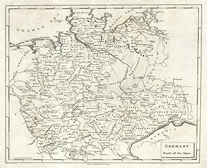
Condizione: Good. Germany South of the Mayn. Arrowsmith & Lewis Bavaria Baden-Württemberg 1812 map. Antique steel engraved map; Arrowsmith, Aaron & Lewis, Samuel (1812). 25.0 x 20.0cm, 9.75 x 8 inches. Condition: Good. There is nothing printed on the reverse side, which is plain.
-

Condizione: Good. Turkey in Europe by Arrowsmith & Lewis. Balkans Greece Romania Bulgaria 1812 map. Antique steel engraved map; Arrowsmith, Aaron & Lewis, Samuel (1812). 25.0 x 20.0cm, 9.75 x 8 inches. Condition: Good. There is nothing printed on the reverse side, which is plain.
-
Condizione: Good. Germany North of the Mayn by Arrowsmith & Lewis 1812 old antique map chart. Antique steel engraved map; Arrowsmith, Aaron & Lewis, Samuel (1812). 25.0 x 20.0cm, 9.75 x 8 inches. Condition: Good. There is nothing printed on the reverse side, which is plain.
-
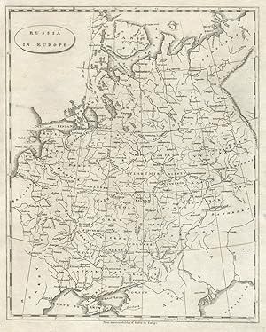
Condizione: Good. Russia in Europe by Arrowsmith & Lewis. Ukraine & Baltic States 1812 old map. Antique steel engraved map; Arrowsmith, Aaron & Lewis, Samuel (1812). 25.0 x 20.0cm, 9.75 x 8 inches. Condition: Good. There is nothing printed on the reverse side, which is plain.
-
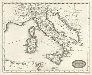
Condizione: Good. Italy by Arrowsmith & Lewis 1812 old antique vintage map plan chart. Antique steel engraved map; Arrowsmith, Aaron & Lewis, Samuel (1812). 25.0 x 20.0cm, 9.75 x 8 inches. Condition: Good. There is nothing printed on the reverse side, which is plain.
-
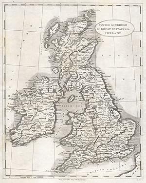
Condizione: Good. United Kingdoms of Great Britain and Ireland by Arrowsmith & Lewis 1812 map. Antique steel engraved map; Arrowsmith, Aaron & Lewis, Samuel (1812). 25.0 x 20.0cm, 9.75 x 8 inches. Condition: Good. There is nothing printed on the reverse side, which is plain.