Importo totale (1 articolo articoli):
Destinazione ordine:

GROSS, ALEXANDER (Oltre 2.000 risultati)
Vai alla pagina principale dei risultati di ricerca
Tipo di articolo
- Tutti gli articoli
- Libri (609)
- Riviste e Giornali (3)
- Fumetti
- Spartiti
- Arte, Stampe e Poster
- Fotografie
- Mappe (1.405)
-
Manoscritti e
Collezionismo cartaceo (2)
Condizioni
Legatura
Ulteriori caratteristiche
- Prima edizione (53)
- Copia autografata (2)
- Sovraccoperta (17)
- Con foto (1.628)
- No print on demand (1.925)
Spedizione gratuita
Paese del venditore
Valutazione venditore
-

Japanese Beauties: Vintage Graphics, 1900-1970 (Icons)
Editore: Taschen, 2004
ISBN 10: 3822831239ISBN 13: 9783822831236
Libro
paperback. Condizione: Very Good. Connecting readers with great books since 1972! Used books may not include companion materials, and may have some shelf wear or limited writing. We ship orders daily and Customer Service is our top priority!.
Ulteriori offerte da altri venditori AbeBooks
Usato - A partire da EUR 2,41
Scopri anche Prima edizione
-

Geographers' famous guide to London 5th edition
Data di pubblicazione: 1964
Da: Library House Internet Sales, Grand Rapids, OH, U.S.A.
Valutazione venditore:

Paperback. Condizione: Fine. No Jacket. Solid binding. Please note the image in this listing is a stock photo and may not match the covers of the actual item. Book.
-

BizTalk 2006 Recipes: A Problem-Solution Approach
Editore: Apress, 2006
ISBN 10: 1590597117ISBN 13: 9781590597118
Libro
paperback. Condizione: Good. Connecting readers with great books since 1972! Used textbooks may not include companion materials such as access codes, etc. May have some wear or writing/highlighting. We ship orders daily and Customer Service is our top priority!.
Ulteriori offerte da altri venditori AbeBooks
Usato - A partire da EUR 5,02
-
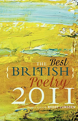
The Best British Poetry 2011
Editore: Salt 15/09/2011, 2011
ISBN 10: 1907773045ISBN 13: 9781907773044
Libro
Condizione: Very Good. This book is in very good condition and will be shipped within 24 hours of ordering. The cover may have some limited signs of wear but the pages are clean, intact and the spine remains undamaged. This book has clearly been well maintained and looked after thus far. Money back guarantee if you are not satisfied. See all our books here, order more than 1 book and get discounted shipping. .
Ulteriori offerte da altri venditori AbeBooks
Usato - A partire da EUR 3,54
-
Soft cover. Condizione: Near Fine. No Jacket. Near Fine glossy quarto wraps gently handled. Bright, snug & unmarked.
-
Famous Guide to New York: Pictorial and Descriptive with 11 Maps and 47 Illustrations
Editore: Geographia Map Co. , Inc., NY, 1947
Paperback. Condizione: Good+. Back cover sl soiled with small amount of penned writing; Paperback. 88 pp. B&W photos, maps. Tourist guide; 12mo; 88 pages.
-
The Son of Man: Studies in His Life and Teachings
Editore: Publishing House of the M. E. Church, Tennessee, 1899
Prima edizione
Hard Cover. Condizione: Good Hardback. Presumed First Edition. brown cloth hardcover with gilt lettering on front and spine; Internally pages are white and bright; ---------- SATISFACTION GUARANTEED --------- FAST, COURTEOUS SERVICE ------ ALL DUSTJACKETS ARE COVERED WITH NEW CLEAR MYLAR PROTECTOR ----- Size: 5 x 8". Previous Owner Signature.
-

The Perma Handy World Atlas
Editore: New York: Permabooks / Permabook / Perma # P70 1st Edition, 1950
Prima edizione
Hard Cover. Condizione: Very Good+. No Jacket. First Edition. ----------small hardcover, issued without a dust jacket. In the late 1940s and the early 1950s, Permabooks issued this series of "hardcover paperbacks", which were the same size (and price) as a conventional paperback, but had hard glossy pictorial covers rather than the usual soft paper covers. The name "Permabooks" was quite apt, as they have stood up quite well over the years. The worlld as it was in 1950, facts, colour maps. Modest wear to spine extremities and corners, a VG+ copy.
-
Soft cover. Condizione: Fair. No Jacket. Geographia World Atlas, Gross, Alexander, Geographia Map Co, New York, 1935, approx 50p, oversz. pb, covers bumped/scuffed/creased, clean text, solid binding, taped spine, name inscribed front cover---6.00.
-
Geographers' Atlas of Central London: Six Inches to One Mile
Editore: Geographers' Map Co. Ltd. 0, London
Soft cover. Condizione: Good +. Moderate wear including exterior soils and light smudges. Book.
-

Bob Dylan: An Illustrated History
Editore: Elm Tree Books, London, 1978
ISBN 10: 0241100380ISBN 13: 9780241100387
Libro
Paperback. Condizione: VERY GOOD. Small scrape on spine. Binding is sound and tight. No writing/markings. 150 pages. -- Please feel free to ask for additional information, or detailed photos. US orders ship USPS from Niagara Falls, NY. Canadian orders ship from Ontario.
-

The Complete Guide To New York: Manhattan and Bronx (With Map)
Editore: The Interborough News Company, 1936
Libro
Paperback. Condizione: Collectible- very good. No Jacket. Includes large colored map and index to streets Fairly clean copy Mostly tight and sound but inside spine beginning to loosen Corner rubs and bumps No inside markings or underlinings Please see our photo as many book sites use stock images.
-

Gehorsame Kirche, ungehorsame Christen im Nationalsozialismus
Editore: Matthias-Grünewald-Verlag, 2000
ISBN 10: 3786722285ISBN 13: 9783786722281
Libro
Taschenbuch. Condizione: Gut. 2. Auflage, 2000 * Einband: etwas abgerieben, leicht nachgedunkelt * Seiten: leichte Lesespuren, wenige Anmerkungen/Hervorhebungen.
Ulteriori offerte da altri venditori AbeBooks
Usato - A partire da EUR 2,49
Scopri anche Copia autografata
-
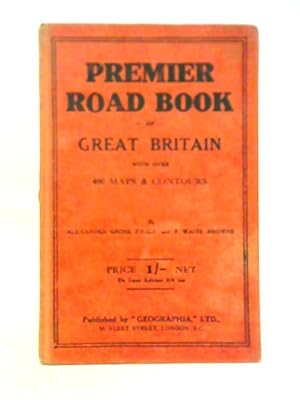
The Premier Road Book of Great Britain With Over 400 Plans And Contours
Editore: Geographia, 1111
Da: World of Rare Books, Goring-by-Sea, SXW, Regno Unito
Valutazione venditore:
Condizione: Fair. No Edition Remarks. 191 pages. No dust jacket. Red cloth. Contains black and white illustrations throughout. Pages remain bright and clear with minimal tanning and foxing. Thumb-marking present. Noticeable creasing to gutter. Boards have moderate edge-wear with bumping to corners and rubbing to surfaces. Noticeable tanning to spine and edges. Some marks overall.
-
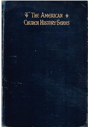
A History of the Methodist Church, South, The United Presbyterian Church, The Cumberland Presbyterian Church and the Presbyterian Church, South (American Church History) Volume XI
Editore: Charles Scribner's Sons, New York, 1927
Hard Cover. Condizione: Fair. No Jacket. 487 pages. Library stamp top of half title page. 285 AL on fep. 280 AL 12615 on copy right page. Small sticker with 1927 same page. Several pages have written notes at the top. Library stamp on edges of pages. Does not intrude into text. Library stamp top and bottom edge of book. Card holder removed inside back cover. Due date slip removed bep. Library bar code bep. Black marker scribbled over writing inside back cover. Wear to the edges. Wear to the corners. Wear to the covers. Wear edges of spine. Libray call number bottom of spine. Spine is tight and there are no loose pages. Size: 8vo - over 7ľ" - 9ľ" tall. Ex-Library.
-
A History of the Methodist Church, South; the United Presbyterian Church, The Cumberland Church, and the Presbyterian Church, South in the United States [American Church History vol. 11]
Editore: New York: The Christian Literature Co., 1894
Hardcover, no dust jacket. Volume 11 only. Ex-library, water stained and worn cover, foxing, worming along the hinges, tender hinges. 487 pp.
-
Cloth. Condizione: Good. No Jacket. ND. circa 1950's. Red cloth w/ black lettering on spine & cvr. Some wear at spine ends & bottom cors. some soil & sm. stains. Innards are clean & tight.stain on foredge.Name stamp on FEP.240 pp. Nice maps.
-
FAMOUS GUIDE TO NEW YORK Pictorial and Descriptive with 12 Maps and 60 Illustrations
Editore: NY: Manhattan Post Card Publishing Co., 1937, 1937
Libro
Paperback. Condizione: Good. Clean and sturdy copy with no markings. Wraps show some rubbing wear, pronounced at spine, and light creases at bottom corners and near spine on front cover. Pages are clean, crisp, and glossy. One page dog-eared. SR.
-
The Complete Street Guide to New York
Editore: Geographia Map Co.
Condizione: Fair. Acceptable condition. World's Fair edition. Reading copy only. Corner of page 143 torn away. Slightly dampstained. Writing inside. In polypropylene bag. (guidebook, NYC, reference).
-
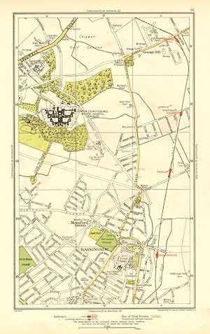
Condizione: Good. LONDON. Barkingside Grange Hill Mossford Green Fairlop 1937 old vintage map. Colour vintage street atlas map; The Geographia map company (1937). 30.5 x 18.5cm, 12 x 7.25 inches. Condition: Good. There is another map printed on the reverse side of this map. The paper is thick, and the map on the reverse side does not show through the paper. Map section #36 This map is one section from a 1937 Street Atlas of Greater London. This section of the map depicts the following suburbs in 1937: Barkingside,Grange Hill,Mossford Green The maps in this series show London during the rapid interwar suburban expansion. Many areas shown in the outer suburbs as undeveloped land on these maps are now built up. Less frequently, some maps indicate housing developments proposed in 1937 but which were never built on land which is still undeveloped, or which has been built up according to a different street layout from that shown. The inner London maps in this series show London before the damage inflicted by the Blitz during World War 2 and the subsequent redevelopment of the 1950's and 1960's. These maps predate the construction of any motorways (the M1 sections into London having opened between 1966-1977), many major roads, and other post-war urban traffic schemes. The elevated sections of many major roads were constructed after the second world war; for example, the maps predate the construction of the Westway and elevated sections of the A4; the Western Avenue is shown on map sections #142 & #143 as proposed or under construction to the west of Northolt Aerodrome. The London docklands are shown at the height of their scale and glory, a network of large docks and railway lines. The last dock to be built had been completed in 1921. The prosperity of the docklands continued until the advent of containerisation 1960's, whereafter they remained derelict until redevelopment commenced in the early 1980's, centred around the area now known as Canary Wharf These maps show a number of now disappeared features, such as aerodromes which have since disappeared or changed their use, the Brooklands motor racing circuit (shown on map section #157, 2 years before it hosted its last race in 1939), and railways which are now disused. LHR is shown on map section #150 as the modest "Great West Aerodrome"; the original Heathrow Hall is also depicted on this map. The airport at that time was used for aircraft assembly and testing, with Croydon Airport (shown on map sections #163 and #164) being the main airport used for commercial flights.
-
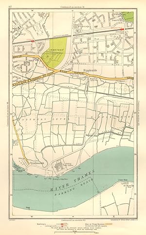
Condizione: Good. LONDON. Creekmouth Rippleside Upney Becontree Thamesmead 1937 old vintage map. Colour vintage street atlas map; The Geographia map company (1937). 30.5 x 18.5cm, 12 x 7.25 inches. Condition: Good. There is another map printed on the reverse side of this map. The paper is thick, and the map on the reverse side does not show through the paper. Map section #67 This map is one section from a 1937 Street Atlas of Greater London. This section of the map depicts the following suburbs in 1937: Creekmouth,Rippleside,Upney The maps in this series show London during the rapid interwar suburban expansion. Many areas shown in the outer suburbs as undeveloped land on these maps are now built up. Less frequently, some maps indicate housing developments proposed in 1937 but which were never built on land which is still undeveloped, or which has been built up according to a different street layout from that shown. The inner London maps in this series show London before the damage inflicted by the Blitz during World War 2 and the subsequent redevelopment of the 1950's and 1960's. These maps predate the construction of any motorways (the M1 sections into London having opened between 1966-1977), many major roads, and other post-war urban traffic schemes. The elevated sections of many major roads were constructed after the second world war; for example, the maps predate the construction of the Westway and elevated sections of the A4; the Western Avenue is shown on map sections #142 & #143 as proposed or under construction to the west of Northolt Aerodrome. The London docklands are shown at the height of their scale and glory, a network of large docks and railway lines. The last dock to be built had been completed in 1921. The prosperity of the docklands continued until the advent of containerisation 1960's, whereafter they remained derelict until redevelopment commenced in the early 1980's, centred around the area now known as Canary Wharf These maps show a number of now disappeared features, such as aerodromes which have since disappeared or changed their use, the Brooklands motor racing circuit (shown on map section #157, 2 years before it hosted its last race in 1939), and railways which are now disused. LHR is shown on map section #150 as the modest "Great West Aerodrome"; the original Heathrow Hall is also depicted on this map. The airport at that time was used for aircraft assembly and testing, with Croydon Airport (shown on map sections #163 and #164) being the main airport used for commercial flights.
-
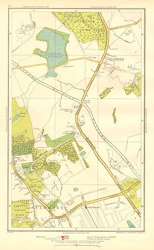
Condizione: Good. HERTS. Elstree Stanmore Edgware Aldenham Park Canons Park 1937 old vintage map. Colour vintage street atlas map; The Geographia map company (1937). 30.5 x 18.5cm, 12 x 7.25 inches. Condition: Good. There is another map printed on the reverse side of this map. The paper is thick, and the map on the reverse side does not show through the paper. Map section #11 This map is one section from a 1937 Street Atlas of Greater London. This section of the map depicts the following suburbs in 1937: Elstree,Stanmore The maps in this series show London during the rapid interwar suburban expansion. Many areas shown in the outer suburbs as undeveloped land on these maps are now built up. Less frequently, some maps indicate housing developments proposed in 1937 but which were never built on land which is still undeveloped, or which has been built up according to a different street layout from that shown. The inner London maps in this series show London before the damage inflicted by the Blitz during World War 2 and the subsequent redevelopment of the 1950's and 1960's. These maps predate the construction of any motorways (the M1 sections into London having opened between 1966-1977), many major roads, and other post-war urban traffic schemes. The elevated sections of many major roads were constructed after the second world war; for example, the maps predate the construction of the Westway and elevated sections of the A4; the Western Avenue is shown on map sections #142 & #143 as proposed or under construction to the west of Northolt Aerodrome. The London docklands are shown at the height of their scale and glory, a network of large docks and railway lines. The last dock to be built had been completed in 1921. The prosperity of the docklands continued until the advent of containerisation 1960's, whereafter they remained derelict until redevelopment commenced in the early 1980's, centred around the area now known as Canary Wharf These maps show a number of now disappeared features, such as aerodromes which have since disappeared or changed their use, the Brooklands motor racing circuit (shown on map section #157, 2 years before it hosted its last race in 1939), and railways which are now disused. LHR is shown on map section #150 as the modest "Great West Aerodrome"; the original Heathrow Hall is also depicted on this map. The airport at that time was used for aircraft assembly and testing, with Croydon Airport (shown on map sections #163 and #164) being the main airport used for commercial flights.
-
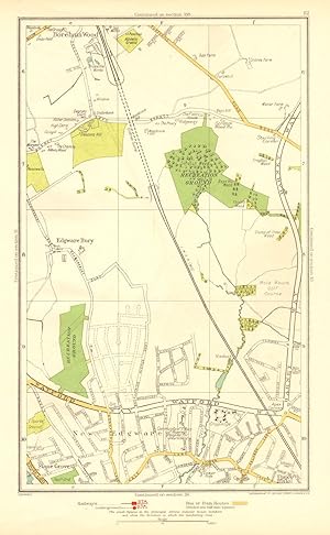
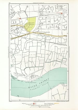
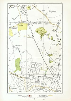
Condizione: Good. LONDON. Edgware Bury New Edgware Stone Grove Upper Hale 1937 old vintage map. Colour vintage street atlas map; The Geographia map company (1937). 30.5 x 18.5cm, 12 x 7.25 inches. Condition: Good. There is another map printed on the reverse side of this map. The paper is thick, and the map on the reverse side does not show through the paper. Map section #12 This map is one section from a 1937 Street Atlas of Greater London. This section of the map depicts the following suburbs in 1937: Edgware Bury,New Edgware,Stone Grove,Upper Hale The maps in this series show London during the rapid interwar suburban expansion. Many areas shown in the outer suburbs as undeveloped land on these maps are now built up. Less frequently, some maps indicate housing developments proposed in 1937 but which were never built on land which is still undeveloped, or which has been built up according to a different street layout from that shown. The inner London maps in this series show London before the damage inflicted by the Blitz during World War 2 and the subsequent redevelopment of the 1950's and 1960's. These maps predate the construction of any motorways (the M1 sections into London having opened between 1966-1977), many major roads, and other post-war urban traffic schemes. The elevated sections of many major roads were constructed after the second world war; for example, the maps predate the construction of the Westway and elevated sections of the A4; the Western Avenue is shown on map sections #142 & #143 as proposed or under construction to the west of Northolt Aerodrome. The London docklands are shown at the height of their scale and glory, a network of large docks and railway lines. The last dock to be built had been completed in 1921. The prosperity of the docklands continued until the advent of containerisation 1960's, whereafter they remained derelict until redevelopment commenced in the early 1980's, centred around the area now known as Canary Wharf These maps show a number of now disappeared features, such as aerodromes which have since disappeared or changed their use, the Brooklands motor racing circuit (shown on map section #157, 2 years before it hosted its last race in 1939), and railways which are now disused. LHR is shown on map section #150 as the modest "Great West Aerodrome"; the original Heathrow Hall is also depicted on this map. The airport at that time was used for aircraft assembly and testing, with Croydon Airport (shown on map sections #163 and #164) being the main airport used for commercial flights.
-
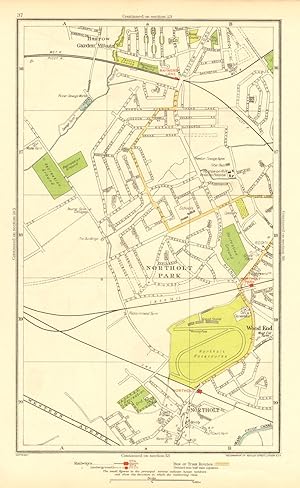
Condizione: Good. NORTHOLT. South Ruislip Harrow Rayner's Lane Wood End Northolt Park 1937 map. Colour vintage street atlas map; The Geographia map company (1937). 30.5 x 18.5cm, 12 x 7.25 inches. Condition: Good. There is another map printed on the reverse side of this map. The paper is thick, and the map on the reverse side does not show through the paper. Map section #37 This map is one section from a 1937 Street Atlas of Greater London. This section of the map depicts the following suburbs in 1937: Northolt,Northolt Park,Wood End The maps in this series show London during the rapid interwar suburban expansion. Many areas shown in the outer suburbs as undeveloped land on these maps are now built up. Less frequently, some maps indicate housing developments proposed in 1937 but which were never built on land which is still undeveloped, or which has been built up according to a different street layout from that shown. The inner London maps in this series show London before the damage inflicted by the Blitz during World War 2 and the subsequent redevelopment of the 1950's and 1960's. These maps predate the construction of any motorways (the M1 sections into London having opened between 1966-1977), many major roads, and other post-war urban traffic schemes. The elevated sections of many major roads were constructed after the second world war; for example, the maps predate the construction of the Westway and elevated sections of the A4; the Western Avenue is shown on map sections #142 & #143 as proposed or under construction to the west of Northolt Aerodrome. The London docklands are shown at the height of their scale and glory, a network of large docks and railway lines. The last dock to be built had been completed in 1921. The prosperity of the docklands continued until the advent of containerisation 1960's, whereafter they remained derelict until redevelopment commenced in the early 1980's, centred around the area now known as Canary Wharf These maps show a number of now disappeared features, such as aerodromes which have since disappeared or changed their use, the Brooklands motor racing circuit (shown on map section #157, 2 years before it hosted its last race in 1939), and railways which are now disused. LHR is shown on map section #150 as the modest "Great West Aerodrome"; the original Heathrow Hall is also depicted on this map. The airport at that time was used for aircraft assembly and testing, with Croydon Airport (shown on map sections #163 and #164) being the main airport used for commercial flights.
-
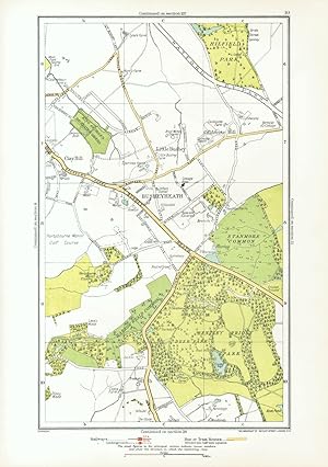
Condizione: Good. HERTS. Busheyheath Caldecote Hill Clay Hill Little Bushey Stanmore Cmn 1933 map. Colour vintage street atlas map; The Geographia map company (1933). 30.5 x 18.5cm, 12 x 7.25 inches. Condition: Good. There is another map printed on the reverse side of this map. The paper is thick, and the map on the reverse side does not show through the paper.
-
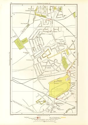
Condizione: Good. NORTHOLT. South Ruislip Harrow Rayner's Lane Wood End Northolt Park 1933 map. Colour vintage street atlas map; The Geographia map company (1933). 30.5 x 18.5cm, 12 x 7.25 inches. Condition: Good. There is another map printed on the reverse side of this map. The paper is thick, and the map on the reverse side does not show through the paper.
-

Condizione: Good. ROMFORD. Chadwell Heath Becontree Dagenham Valence Park 1933 old vintage map. Colour vintage street atlas map; The Geographia map company (1933). 30.5 x 18.5cm, 12 x 7.25 inches. Condition: Good. There is another map printed on the reverse side of this map. The paper is thick, and the map on the reverse side does not show through the paper.
-
Condizione: Good. LONDON. Creekmouth Rippleside Upney Becontree Thamesmead 1933 old vintage map. Colour vintage street atlas map; The Geographia map company (1933). 30.5 x 18.5cm, 12 x 7.25 inches. Condition: Good. There is another map printed on the reverse side of this map. The paper is thick, and the map on the reverse side does not show through the paper.
-
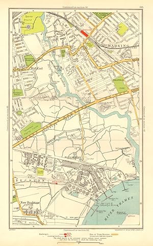
Condizione: Good. LONDON. Barking Beckton Cyprus New Beckton Wall End 1937 old vintage map chart. Colour vintage street atlas map; The Geographia map company (1937). 30.5 x 18.5cm, 12 x 7.25 inches. Condition: Good. There is another map printed on the reverse side of this map. The paper is thick, and the map on the reverse side does not show through the paper. Map section #66 This map is one section from a 1937 Street Atlas of Greater London. This section of the map depicts the following suburbs in 1937: Barking,Beckton,Cyprus,New Beckton ,Wall End The maps in this series show London during the rapid interwar suburban expansion. Many areas shown in the outer suburbs as undeveloped land on these maps are now built up. Less frequently, some maps indicate housing developments proposed in 1937 but which were never built on land which is still undeveloped, or which has been built up according to a different street layout from that shown. The inner London maps in this series show London before the damage inflicted by the Blitz during World War 2 and the subsequent redevelopment of the 1950's and 1960's. These maps predate the construction of any motorways (the M1 sections into London having opened between 1966-1977), many major roads, and other post-war urban traffic schemes. The elevated sections of many major roads were constructed after the second world war; for example, the maps predate the construction of the Westway and elevated sections of the A4; the Western Avenue is shown on map sections #142 & #143 as proposed or under construction to the west of Northolt Aerodrome. The London docklands are shown at the height of their scale and glory, a network of large docks and railway lines. The last dock to be built had been completed in 1921. The prosperity of the docklands continued until the advent of containerisation 1960's, whereafter they remained derelict until redevelopment commenced in the early 1980's, centred around the area now known as Canary Wharf These maps show a number of now disappeared features, such as aerodromes which have since disappeared or changed their use, the Brooklands motor racing circuit (shown on map section #157, 2 years before it hosted its last race in 1939), and railways which are now disused. LHR is shown on map section #150 as the modest "Great West Aerodrome"; the original Heathrow Hall is also depicted on this map. The airport at that time was used for aircraft assembly and testing, with Croydon Airport (shown on map sections #163 and #164) being the main airport used for commercial flights.
-
Condizione: Good. LONDON. Edgware Bury New Edgware Stone Grove Upper Hale 1933 old vintage map. Colour vintage street atlas map; The Geographia map company (1933). 30.5 x 18.5cm, 12 x 7.25 inches. Condition: Good. There is another map printed on the reverse side of this map. The paper is thick, and the map on the reverse side does not show through the paper.