Importo totale (1 articolo articoli):
Destinazione ordine:

HOMANN, HEIRS (208 risultati)
Vai alla pagina principale dei risultati di ricerca
Tipo di articolo
- Tutti gli articoli
- Libri (61)
- Riviste e Giornali
- Fumetti
- Spartiti
- Arte, Stampe e Poster (62)
- Fotografie
- Mappe (85)
-
Manoscritti e
Collezionismo cartaceo
Condizioni
- Tutte
- Nuovi
- Antichi o usati
Legatura
Ulteriori caratteristiche
- Prima edizione (2)
- Copia autografata
- Sovraccoperta (2)
- Con foto (185)
- No print on demand
Paese del venditore
Valutazione venditore
-
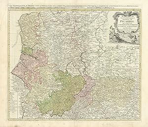
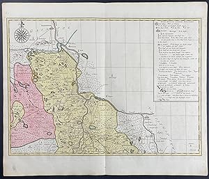
Carte du Gouvernement General de Picardie qui Comprend la Generalite d'Amiens avec l'Artois & les Frontieres des Pays Bas
Data di pubblicazione: 1746
Mappa
Condizione: Good. Carte du Gouvernement General de Picardie qui Comprend HOMANN HEIRS 1746 map. Original folio 18th century antique atlas map with wide margins and original hand colour; Homann heirs (1746). 53.0 x 62.0cm, 20.75 x 24.5 inches; this is a folding map. Condition: Good. There is nothing printed on the reverse side, which is plain.
-
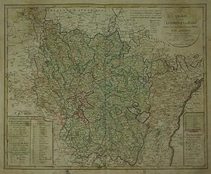
Charte von Lothringen und Barr Nebst den drey Bisthümern Metz, Toul und Verdun. Nach den besten französischen Charten entmorsen und verbessert von F.L. Güssefeld.
Editore: Nuremberg:, 1793
Da: Robert Frew Ltd. ABA ILAB, London, Regno Unito
Membro dell'associazione: ABA ILAB PBFA
Valutazione venditore:

Mappa
46.5 x 57.4 cm. Double page copper engraved map of Lorraine. Original colour in block and outline. Old brief title inscriptions in ink to verso of map. Staining and offsetting across sheet.
-
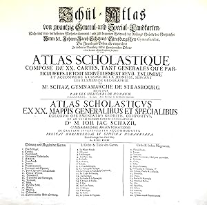
Schul-Atlas von zwantzig General- und Special-Landkarten, nach einer verbesserten Methode illuminirt, und zum bequemen Gebrauch der Anfangs-Gründe der Geographie . der Jugend zum Besten also eingerichtet / Atlas scholastique, composé de XX. cartes . / Atlas scholasticus ex XX. mappis .
Editore: Nürnberg: Homännische Officin dat. ,, 1745
Da: Antiquariat Ruthild Jäger, Lueneburg, Germania
Membro dell'associazione: ILAB VDA
Valutazione venditore:

(Gr.-Folio). 1 Blatt (mittig gefaltet), 56 x 51 cm. (minimale Randeinrisse sorgfältig unterlegt, sonst sehr gut erhalten; small tears in the margins repaired, otherwise in good condition). * Auf dem deutsch/französisch/lateinischen Titelblatt werden die zwanzig im Atlas enthaltenen Landkarten aufgeführt. Der Homann'sche Schul-Atlas war konzipiert als Ergänzung des Geographie-Lehrbuches für Schulen aus der Feder des Gymnasialdirektors Johann Jacob Schatz (1720 Rektor in Trarbach, 1728 Direktor und Bibliothekar Gymnasium Eisenach, 1737 Direktor Gymnasium Straßburg). (#9677AB).
-
Ducatus Iuliaci & Bergensis Tabula Geographia, simul Ducatum Cliviae & Meursiae .
Editore: Nurembergc., 1750
Da: Robert Frew Ltd. ABA ILAB, London, Regno Unito
Membro dell'associazione: ABA ILAB PBFA
Valutazione venditore:
Mappa
57 x 48.2 cm. Original colour in block and outline. Double page map showing the duchies of Julich, Berg and Cleves. Paper browned unevenly.
-
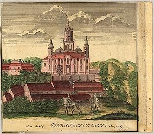
Das Schloß Fürstenstein von Morgen Scenographia Urbium Silesiae, tab. VI, 1738, Homann Heirs. Das ist VORSTELLUNG der Prospecte von den Staedten SCHLESIENS. sechste Tabell. in welcher die Fürnehmsten Staedte des Fürst. SCHWEIDNITZ accurat vorgestellet werden, entworfen von F.B.Werner Siles. und angefertigt von den Homaennischen Erben. Nürnberg 1738. Cum pr. S.C.M.
Editore: Fr. B. Werner, Nürnberg, 1738
Da: Antiquariat Reinhold Berg eK Inh. R.Berg, Regensburg, Germania
Membro dell'associazione: ILAB VDA
Valutazione venditore:

Mappa
Other. Original antique copper engraving, hand colored in outline and wash, when published. Depict one view (from nine) of the,Scenographia Urbium Silesiae, tab. VI published 1738 by Homann Heirs, engraved from F.B. Werner. Cut close to engraved borderline of the map. Upper left side with a small mended tear in the margin, else in good condition. 150 by 150mm (6 by 6 inches). 150 by 150mm (6 by 6 inches).
-
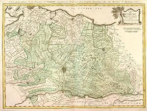
CARTE VON UTRECHT . Detailed map of the area 25 km around Utrecht, reaching to Bunschoten, Wageningen, Schoonhoven and Amsterdam. Published by Homann Heirs after
Editore: Franz Ludwig Güssefeld 1787, 1787
Mappa
42x57cm. The map in full original colour. Excellent condition.
-
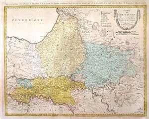
CHARTE VON GELDERLAND UND DER DAZUGEHÖRIGEN GRAFSCHAFT ZUTPHEN . Map of Gelderland and Zutphen, provinces in eastern Holland, reaching from Kampen to Enschede, Emmerich, Bommel and Utrecht. Published by Homann Heirs after
Editore: Franz Ludwig Güssefeld 1787, 1787
Mappa
45x58cm. The map in full original colour. Overall agetoning, otherwise good condition.
-
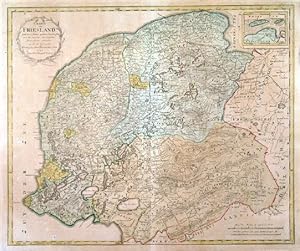
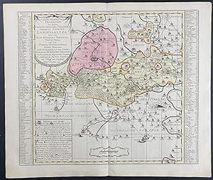
CHARTE VON FRIESLAND . Map of Friesland, Groningen and Drenthe, provinces in northern Holland. Published by Homann Heirs after
Editore: Franz Ludwig Güssefeld 1786, 1786
Mappa
47x57cm. The map in full original colour. Overall agetoning, otherwise good condition.
-
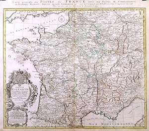
GALLIA POSTARUM GEOGRAPHICE DESIGNATA. / CARTE GENERALE DES POSTES DE LA FRANCE . A general post map of France showing the connections and communications. After Hubert Jaillot published in Nürnberg by
Editore: Homann Heirs 1745, 1745
Mappa
48 x 56 cm. Original outline colour. Excellent condition.
-
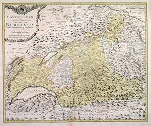
CANTON BERN SIVE ILLUSTRIS HELVETIORUM RESPUBLICA BERNENSIS. . Map of Kanton Bern and adjacent cantons in western Switzerland between Basel, Zürich, Rhone, Lac Leman / Genfer See and Lac de Neuchatel. Large cartouche with coat of arms. After Gabriel Walser published by
Editore: Homann Heirs 1766, 1766
Mappa
47x57cm. The map in full original colour. Excellent condition.
-
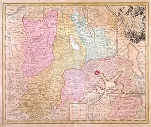
CANTON LUCERN SIVE ILLUSTRIS HELVETIORUM RESPUBLICA LUCERNENSIS . Map of Kanton Luzern in Switzerland with pictorial cartouche, small table of explanations and inset map of Giessenberg. Designed by Gabriel Walser and published by
Editore: Homann Heirs 1763, 1763
Mappa
47x57cm. The map in full original colour. Slight overall browning, otherwise very good condition.
-
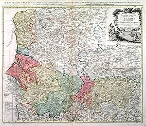
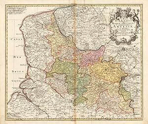
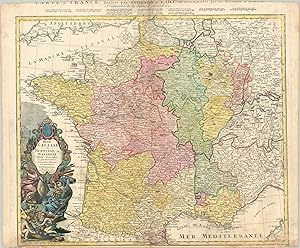
CARTE DU GOUVERNEMENT GENERAL DE PICARDIE QUI COMPREND LA GENERALITÉ D AMIENS AVEC L ARTOIS & LES FRONTIERES DES PAYS BAS .Map of northeast France between Paris and Dieppe / Calais, reaching east to the Belgian border. After Guillaume De L Isle published by
Editore: Homann Heirs 1746, 1746
Mappa
47x56cm. Full original colour. Excellent condition.
-

CARTE DE LA SOUVERAINETÉ DE NEUFCHATEL ET VALANGIN. . Detailed map of the close area to the northwest of Lake Neuchatel in Switzerland, reaching to La-Chaux-de-Fonds and Morteau.
Editore: Homann Heirs 1778, 1778
Mappa
41x58cm. Full original colour. Excellent condition.
-
Carte D Artois et des Environs Vel Mappa Specalis Comitatus Artesiae in qua simul Terrae Iurisdictionales.de l Isle designata. Recudentibus Homannianis Heredib.
Editore: Homann Heirs 1740-50, Nürnberg, 1740
Da: Antiquariat Reinhold Berg eK Inh. R.Berg, Regensburg, Germania
Membro dell'associazione: ILAB VDA
Valutazione venditore:
Mappa
Other. Original antique copper engraving, hand colored and wash when published. Ornated in the upper right corner with a large allegoric title cartouche, as well a small mileage scale in the upper left corner. Fine detailed engraved map showing the duchy of Artois with its surroundings. With many place names and details like streets, woods, mountains, rivers, lakes etc. Still in very good condition, a minor gluestaining at the centre-fold. 482 by 570mm (19 by 22 inches).
-
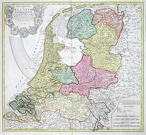
Septem Provinciae seu Belgium Foederatum quod generaliter Hollandia audit
Editore: Homann Heirs, Nuremberg, 1748
Mappa
Kein Einband. Condizione: Gut bis sehr gut. The Netherlands. "Septem Provinciae seu Belgium Foederatum quod generaliter Hollandia audit". Orig. copperplate engraving published by Homann's Heirs, 1748 after T. Maier's map. Original old colouring. With great heraldic title cartouche (with 7 coats-of-arms). 47:51,5 cm (18 1/2 x 20 1/4 inch.). Detailed map of the Low Countries, with 7 coats of arms of Geldern, Holland, Zeeland, Utrecht, Friesland, Ober Issel and Groningen.
-
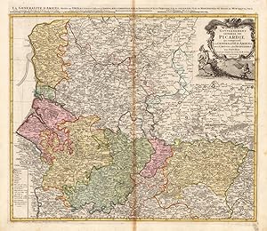
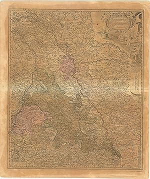
Carte du Govvernement General de Picardie qui comprend La Generalite D Amiens avec L Artois & les Frontieres des Pays Bas.
Editore: Homann Heirs, Nürnberg, 1746
Da: Antiquariat Reinhold Berg eK Inh. R.Berg, Regensburg, Germania
Membro dell'associazione: ILAB VDA
Valutazione venditore:
Mappa
Other. Original antique copper engraving, hand colored and wash when published. Ornated in the upper right corner with a large allegoric title cartouche, as well a small table of explanations in the lower left corner. Fine detailed engraved map showing the government of the Picardie, including Amiens, Artois and the borders to Belgium. With many place names and details like streets, woods, mountains, rivers, lakes etc. In very good condition, slightly visable gluestaining at the centre-fold. 480 by 552mm (19 by 21 inches). 480 by 552mm (19 by 21 inches).
-
Carte du Cercle de Budissin dans la Margaffin de la Haute Lusace.
Editore: Heirs of Homann, 1746., 1746
Libro
Soft cover. Condizione: Good. Nineteenth-century brown morocco slipcase.
-
Carte du Cercle de Goerlitz dans la Margaffin de la Haute Lusace.
Editore: Heirs of Homann, 1746., 1746
Libro
Soft cover. Condizione: Good. Nineteenth-century brown morocco slipcase.
-
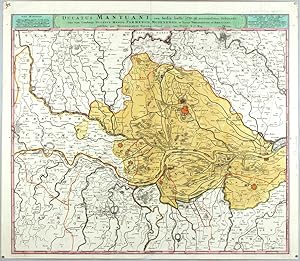
Ducatus Mantuani, ceu Sedis belli 1733-35 recentissima Delineatio
Editore: Homann Heirs, Nuremberg, 1735
Mappa
Kein Einband. Condizione: Sehr gut. Mantua. "Ducatus Mantuani, ceu Sedis belli 1733-35 recentissima Delineatio, una cum Ducatus Mediol. Parmensis, Modenensis, et Territ. Veronensis et Bresciani". Orig. copperplate engraving, Homann's Heirs, 1735. With title bar above the map. 49,5:57,5 cm (19 1/2 x 22 3/4 inch.). Map of the province of Mantova in Lombardy. With red coloured fortified towns of Mantova, Mirandola, Guidizollo and others. - Beautiful impression with rich colours.
-
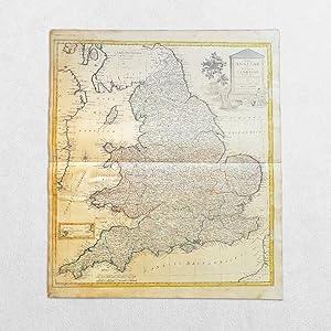
(United Kingdom) Regni Angliae Et Principatus Cambriae Tabula Nova Ad Prototypon Kitchinianum
Data di pubblicazione: 1793
Libro
No Binding. Condizione: Good. Original copper engraving. Date: 1793. Sheet size: 54.8cm x 63.2cm. Contemporary outline hand-colouring. Age toning, staining and marks to the margins with a mark to the west of Wales. In good condition overall. Scarce.
-
Regni Galliae seu Franciae et Navarrae Highly decroative map of France published during the War of Austrian Succession.
Data di pubblicazione: 1741
Da: Curtis Wright Maps, Berwyn, IL, U.S.A.
Membro dell'associazione: ESA MWABA
Valutazione venditore:
Condizione: Very Good. The death of Holy Roman Emperor Charles VI in 1740 led to a dynastic challenge of the Hapsburg successor, Maria Theresa of Austria. France and Prussia refused to acknowledge the principle of female hereditary rule and backed Charles Albert of Bavaria as the rightful heir. The resulting conflict was known appropriately as the War of Austrian Succession (1740 - 1748) and pitted the Pragmatic Allies (the HRE, Britain, Hanover, and the Dutch Republic) against Louis XIV's France, Prussia, and the Spanish Bourbons. This map of France was published by the Homann Heirs firm after the first year of conflict, in 1741. It shows the territorial extent of France, with the original hand color highlighting the outline of each province. An interesting variety of chateaus, towns, geographic features, forts, and other locations of interest are labeled throughout the image. The decorative title cartouche in the lower left features numerous symbols representing French culture, martial prowess, and regal authority. The royal coat of arms sits atop an elaborate rococo statue with numerous weapons of war, including cannons and hand-held firearms - the war features several early examples of their widespread use in battle. In the foreground are two allegorical figures - probably Hercules with the head of the Nemean Lion and Athena with the aegis. Various elements symbolizing culture and science - a globe, quadrant, slide calipers and paint set - are scattered on the ground and two puttis can be seen squeezing grapes into wine. An incredible depiction of France during the reign of the Sun King! Sheet Width (in) 24 Sheet Height (in) 19.9 Condition Description Trimmed margins show heavy wear and soiling, most evident at the top of the sheet, which is missing a portion of the text. Moderate scattered discoloration also visible within the image, most evident to the immediate right of the title cartouche. Better than fair, but not quite good condition overall. Issued on watermarked paper with several old annotations underlining various cities.
-
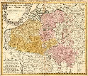
Belgium Catholicum seu Decem Provinciae Germaniae Inferioris cum consiniis Germaniae Sup. et Franciae Legitime omnia delineata et ad duetum observationum astronomicarum, nen non Geometriacarum operationum a Cassinio Snellio Muschenbrokio aliisquerite habitarum examinata studiosissime et representata a Tob. Maiero. Math. Cult. Edentibus Homannianis Heredib. A. 1747 Carte des Pais Bas Catholiques ou des X Provinces de l Allemagne Inserieure etc dessinée au juste selon les exactes observations Astronomiques et Operations Geometriques des Messur. Cassini. Snellius. Muschenbrok etc. dressee par Sr. Tobias Maier Mathematicien. Aux depens des Heritiers de Homann. 1 An 1747. Avec Privil Imperial
Editore: Nürnberg, 1747
Da: Antiquariat Reinhold Berg eK Inh. R.Berg, Regensburg, Germania
Membro dell'associazione: ILAB VDA
Valutazione venditore:
Mappa
Other. Original antique copper engraving, hand colored in outline and wash when published. This antique map shows Belgium with its neighboring counties Luxembourg and Holland. The map is equipped with many place names, rivers, woods, lakes, etc. Around the title, which is in the upper left corner, are many coat of arms. In the lower left corner we see an allegoric cartouche, which has the mileage scale inside. The explanation from the map is in the lower right corner. In good condition. Cut close to the descriptive text at the top of the map. A small mending at the bottom of the centre fold, a few minor spots, mostly only visible verso. 474 by 556mm (18 by 22 inches). 474 by 556mm (18 by 22 inches).
-
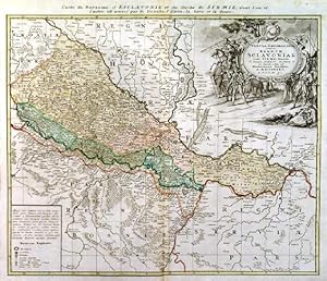
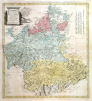
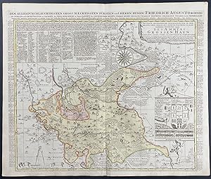
TABULA GEOGRAPHICA EXHIBENS REGNUM SCLAVONIAE CUM SYRMII DUCATU . . Map of the eastern part of Croatia between the rivers Drava and Sava, reaching from Belgrad (Serbia) to Vellika and Virovitica (Croatia), with large figurative cartouche and table of explanations.
Editore: Homann Heirs 1745, 1745
Mappa
46x56cm. The map in full original colour. Occasional slightly browned white margins. Excellent condition.
-
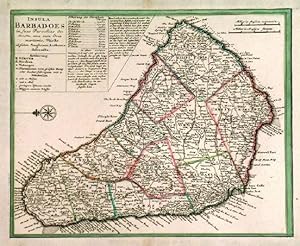
INSULA BARBADOES IN SUAS PAROCHIAS DISTINCTA. . Detailed map of Barbados, north orientated to the left.
Editore: Homann Heirs ca. 1740, 1740
Mappa
22x28cm. Left, lower and upper border trimmed to neatline as issued and margins extended. Original outline colour. Excellent condition.
-
No Binding. Condizione: Very Good. 50x45cm. The map in full original colour. Excellent condition. Small insignificant brown spot, otherwise fine.
-
Regional Map of Europe
Editore: Nuremberg, 1750
Da: Trillium Antique Prints & Rare Books, Franklin, TN, U.S.A.
Valutazione venditore:
Arte / Stampa / Poster
Condizione: Fine. This engraving is from a composite atlas presented by the Homann Heirs. Many of the maps in the collection were completed by Peter Schenk or J. B. Homann. The maps were originally published from 1710 to the mid 1800s in Amsterdam and Nuremberg by the Homann Heirs.Following the decline of the great Dutch publishers, the Homann family became one of the most important map publishing houses in Germany. Founded in Nuremberg by Johann Baptist Homann in 1702, the Homann empire dominated Germany's map market for over a century. Homann published his first major atlas in 1707 and was soon after appointed Geographer to the Emperor. After Homann's death in 1724, the firm was continued by his son until 1730. The business was then bequeathed to his heirs with the stipulation that it conducted business under the name of Homann Heirs.The Homann family continued to produce maps until the beginning of the nineteenth century, and remained one of the most important German publishers on the Continent. They published a Neuer Atlas in 1714, a Grosser Atlas in 1737 and an Atlas Maior in 1780. In addition they issued an atlas of German town plans, numerous school atlases, and an atlas of 20 maps of Silesia. Their excellent work had a lasting impact on European maps during the eighteenth century. --- The work is in good to excellent condition overall. There is some faint toning or smudging mostly present in margins. There may be a few minor imperfections or faint marks to be expected with age. There may be some faint bleed through or offset to the fold out plates. Please review the image carefully for condition and contact us with any questions. --- Paper Size ~ 25 1/4" by 21".