
Importo totale (1 articolo articoli):
Destinazione ordine:

HOPKINS, G M & CO (20 risultati)
Vai alla pagina principale dei risultati di ricerca
Tipo di articolo
- Tutti gli articoli
- Libri (20)
- Riviste e Giornali
- Fumetti
- Spartiti
- Arte, Stampe e Poster
- Fotografie
- Mappe
-
Manoscritti e
Collezionismo cartaceo
Condizioni
Legatura
Ulteriori caratteristiche
- Prima edizione (3)
- Copia autografata
- Sovraccoperta
- Con foto (15)
- No print on demand (18)
Spedizione gratuita
Paese del venditore
Valutazione venditore
-

Technology and Society: Building our Sociotechnical Future (Inside Technology)
Editore: The MIT Press, 2008
ISBN 10: 0262600730ISBN 13: 9780262600736
Libro
paperback. Condizione: As New. LIKE NEW!!! Has a red or black remainder mark on bottom/exterior edge of pages.
Ulteriori offerte da altri venditori AbeBooks
Usato - A partire da EUR 3,75
-
![Immagine del venditore per Atlas of the county of Montgomery and the state of Pennsylvania; (1871) [LeatherBound] venduto da True World of Books](https://pictures.abebooks.com/inventory/md/md31657471581.jpg)
Atlas of the county of Montgomery and the state of Pennsylvania; (1871) [LeatherBound]
Data di pubblicazione: 2023
Libro Print on Demand
LeatherBound. Condizione: New. LeatherBound edition. Condition: New. Reprinted from 1871 edition. Leather Binding on Spine and Corners with Golden leaf printing on spine. Bound in genuine leather with Satin ribbon page markers and Spine with raised gilt bands. A perfect gift for your loved ones. NO changes have been made to the original text. This is NOT a retyped or an ocr'd reprint. Illustrations, Index, if any, are included in black and white. Each page is checked manually before printing. As this print on demand book is reprinted from a very old book, there could be some missing or flawed pages, but we always try to make the book as complete as possible. Fold-outs, if any, are not part of the book. If the original book was published in multiple volumes then this reprint is of only one volume, not the whole set. Sewing binding for longer life, where the book block is actually sewn (smythe sewn/section sewn) with thread before binding which results in a more durable type of binding. Pages: 134 G.M. Hopkins & Co.
-
![Immagine del venditore per Atlas of the County of Lawrence and the State of Pennsylvania :b from actual surveys and official records / compiled and published by G. M. Hopkins & Co. (1978) [LeatherBound] venduto da S N Books World](https://pictures.abebooks.com/inventory/md/md31650103745.jpg)
Atlas of the County of Lawrence and the State of Pennsylvania :b from actual surveys and official records / compiled and published by G. M. Hopkins & Co. (1978) [LeatherBound]
Data di pubblicazione: 2022
Libro Print on Demand
LeatherBound. Condizione: New. Leatherbound edition. Condition: New. Leather Binding on Spine and Corners with Golden leaf printing on spine. Bound in genuine leather with Satin ribbon page markers and Spine with raised gilt bands. A perfect gift for your loved ones. Reprinted from 1978 edition. NO changes have been made to the original text. This is NOT a retyped or an ocr'd reprint. Illustrations, Index, if any, are included in black and white. Each page is checked manually before printing. As this print on demand book is reprinted from a very old book, there could be some missing or flawed pages, but we always try to make the book as complete as possible. Fold-outs, if any, are not part of the book. If the original book was published in multiple volumes then this reprint is of only one volume, not the whole set. IF YOU WISH TO ORDER PARTICULAR VOLUME OR ALL THE VOLUMES YOU CAN CONTACT US. Resized as per current standards. Sewing binding for longer life, where the book block is actually sewn (smythe sewn/section sewn) with thread before binding which results in a more durable type of binding. Pages: 506 Language: English Pages: 506.
-

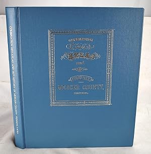
Combination Atlas of the County of Mercer and the State of Pennsylvania from Actual Records & Official Records
Editore: Windmill Books, Inc., Mount Vernon, NY, 1993
Hardcover. Condizione: Near Fine. Reprint. Near fine, nice bright copy, light spotting on top edge ; Folio 13" - 23" tall; 156 pages.
-
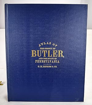
Combination atlas of the county of Butler and the state of Pennsylvania : from actual surveys & official records
Editore: Butler Public Library, 1982
Libro
Hardcover. Condizione: As New. [Fine] Square folio; 39 cm. Bound in publisher's blue cloth. Hardcover. Good binding and cover. Clean, unmarked pages. 111 pages : illustrations, maps . Facsimile reprint of the 1874 edition published by G.M. Hopkins & Co., Philadelphia, Pa.
-
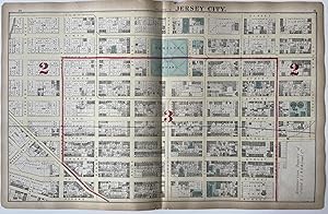
Plate: E. Jersey City
Editore: G.M. Hopkins & Co, Philadelphia
Da: Argosy Book Store, ABAA, ILAB, New York, NY, U.S.A.
Membro dell'associazione: ABAA ILAB
Valutazione venditore:

Map. Engraving with original hand coloring. Measures 17 1/2" x 27 3/8". This map of Jersey City centers on the area of Hamilton Square, showing the railroad and surroundings streets. Published in 1873, the map is an example of a real estate, plat, or ward map - which show detailed information regarding land division, property ownership, and public infrastructure. Map extends north to south from 10th St. to 2nd St., and east to west from Provost Street to Paterson St. (present-day Division St.) Includes parts of Newark Ave. Red hand coloring outlines the ward boundaries, showing wards 2 and 3. Streets are clearly labeled. Between the streets, plots of land are labeled by number, and include names of landowners. Significant landmarks such as churches and schools are labeled and colored in green. Other labeled landmarks include a bank, children's home, and two breweries, as well as Jersey City Gas Works, and various lots owned by United NJ RR & Canal Co. and Erie RR Co. The map appeared in G.M. Hopkins & Co.'s "Combined Atlas of the State of New Jersey and the county of Hudson." It is in good overall condition. Image extends to the edges of the sheet on all sides. Minor chips and tears to outer margin. G.M. Hopkins & Co. was a Philadelphia-based publishing firm. Between 1870 and 1940, the company produced over 175 atlases and real estate plat maps of cities, counties, and townships in 18 different states and the District of Columbia. Today, their maps offer a detailed insight into the ways many cities have - and haven't - changed in the course of the last century.
-
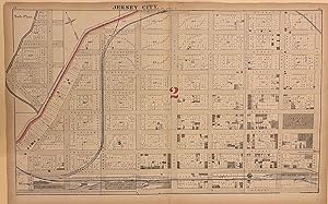
Plate: F. Jersey City
Editore: G.M. Hopkins & Co, Philadelphia
Da: Argosy Book Store, ABAA, ILAB, New York, NY, U.S.A.
Membro dell'associazione: ABAA ILAB
Valutazione venditore:
Map. Engraving with original hand coloring. Measures 17 1/2" x 27 3/8". This map of Jersey City, published in 1873, is an example of a real estate, plat, or ward map - which show detailed information regarding land division, property ownership, and public infrastructure. Extending from 10th to 19th Streets, and from Provost Street to Hoboken Ave, the map depicts the northernmost part of Downtown Jersey City, showing the railroad, factories and warehouses, and residential structures. Streets are clearly labeled. Between the streets, plots of land are labeled by number, and include names of landowners. Most of this neighborhood was demolished for construction of the Holland Tunnel, which opened in 1927. The map appeared in G.M. Hopkins & Co.'s "Combined Atlas of the State of New Jersey and the county of Hudson." It is in good overall condition. Minor chips and tears to edges, not affecting the image. G.M. Hopkins & Co. was a Philadelphia-based publishing firm. Between 1870 and 1940, the company produced over 175 atlases and real estate plat maps of cities, counties, and townships in 18 different states and the District of Columbia. Today, their maps offer a detailed insight into the ways many cities have - and haven't - changed in the course of the last century.
-
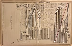
Plate: B. Jersey City
Editore: G.M. Hopkins & Co, Philadelphia
Da: Argosy Book Store, ABAA, ILAB, New York, NY, U.S.A.
Membro dell'associazione: ABAA ILAB
Valutazione venditore:
Map. Engraving with original hand coloring. Measures 17 1/2" x 27 3/8". This map of Jersey City, published in 1873, is an example of a real estate, plat, or ward map - which show detailed information regarding land division, property ownership, and public infrastructure. This map features part of the downtown waterfront, showing piers, ferry buildings, rail lines and depots, and coal docks. Streets are clearly labeled. Between the streets, plots of land are labeled by number, and include names of landowners. The map shows the natural coastline along Pavonia Ave, with the grid plan extended into Harsimus Cove, which would soon be land-filled. Most of this area was demolished for construction of the Holland Tunnel, which opened in 1927, and later, the Newport section of Jersey City. The map appeared in G.M. Hopkins & Co.'s "Combined Atlas of the State of New Jersey and the county of Hudson." It is in good overall condition. Minor chips and tears to edges, not affecting the image. G.M. Hopkins & Co. was a Philadelphia-based publishing firm. Between 1870 and 1940, the company produced over 175 atlases and real estate plat maps of cities, counties, and townships in 18 different states and the District of Columbia. Today, their maps offer a detailed insight into the ways many cities have - and haven't - changed in the course of the last century.
-
Map of the City of Boston and its Environs. Published by G. M. Hopkins & Co. . Engr. By E. Busch . Printed by F. Bourquin.
Editore: Philadelphia:, 1874
Condizione: Good. hand colored pocket map, approximately 84 cm. x 72 cm. when open, 15.5 cm. tall when closed, in original black cloth folder; the folder neatly rebacked in red and substantial portions of the border of the back cover rubbed away, light general age toning to map with minor holing at intersecting folds. - If you are reading this, this item is actually (physically) in our stock and ready for shipment once ordered. We are not bookjackers. Buyer is responsible for any additional duties, taxes, or fees required by recipient's country. Photos available upon request.
-
Atlas of Montgomery County and the State of Pennsylvania
Editore: UNIGRAPHIC, EVANSVILLE, INDIANA, 1976
Da: Princeton Antiques Bookshop, Atlantic City, NJ, U.S.A.
Valutazione venditore:

HARD BACK GREEN. Condizione: GOOD. General wear: soiled cover, bookplate, yellowing--otherwise very good condition Contains many B&W maps and illustrations (Fort Washington Mills, Althouse Carraige builder house, Lumber Yard and residence Shearer, etc.) DATE PUBLISHED: 1976 EDITION: 162 EST.
-
Combination 1873 Atlas and 1877 History of Mercer County, Pennsylvania
Editore: Windmill Publications, 1993
Libro
Hardcover. Condizione: As New. Bound in blue cloth. Gilt decoration on front board. Hardcover. Good binding and cover. Minor shelf wear. Corner bumped. Clean, unmarked pages. This is an oversized or heavy book, which requires additional postage for international delivery outside the US.
-
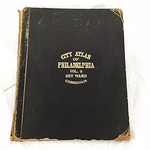
Atlas of the city of Philadelphia : 25th ward, from official records, private plans, and actual surveys (Volume 4)
Editore: Philadelphia, Pa : G.M. Hopkins, 1886
Libro
Hardcover. Condizione: Good. Atlas folio. 20 color maps. Hardcover. Spine hinge cracked, detached. Clean, unmarked pages. Real property -- Pennsylvania -- Philadelphia -- Maps. This is an oversized or heavy book, that requires additional postage for international delivery outside the US.
-
Combined Atlas of the County of Suffolk, Massachusetts, Vol. 2nd, Late City of Roxbury, Now Wards 13-14 and 15, City of Boston
Editore: Philadelphia, Philadelphia, 1873
Da: High Ridge Books, Inc. - ABAA, South Deerfield, MA, U.S.A.
Membro dell'associazione: ABAA ESA ILAB SNEAB
Valutazione venditore:
Original 1/2 leather with cloth. Internally very good. Land owners identified. Extends up to the western section of Back Bay where much of the area is still underwater or marsh. This section includes the modern location of Fenway Park (built almost 40 years later), which would have been largely under water at the time. 18 maps, hand-colored. The front cover identifies the area covered as the Boston Highlands. LeGear L1584.
-
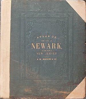
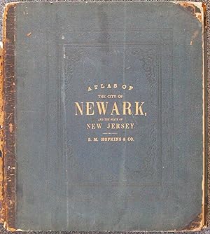
Combined Atlas of the State of New Jersey and the City of Newark from Actual Survey, Official Records & Private Plans
Editore: Philadelphia, Philadelphia, 1873
Da: High Ridge Books, Inc. - ABAA, South Deerfield, MA, U.S.A.
Membro dell'associazione: ABAA ESA ILAB SNEAB
Valutazione venditore:
Original boards with later cloth spine and tips. 113, 6 pp., including 34 hand-colored maps. Some chipping and wear at edges. This is the first atlas of Newark and is combined with what can be deemed the second atlas of New Jersey, later only than the Beers state atlas of 1872. The city maps are fully colored by ward with land owners identified. The county maps in the state sections are fully colored by town. LeGear L2373.
-
Plat-Book of the City of Toledo, Ohio, and Suburbs
Da: G.S. MacManus Co., ABAA, Bryn Mawr, PA, U.S.A.
Membro dell'associazione: ABAA ILAB
Valutazione venditore:
Prima edizione
(OHIO). (TOLEDO). G. M. HOPKINS Co. Plat-book of the City of Toledo, Ohio, and Suburbs complete in One Volume. From Official Records, Private Plans and Actual Surveys. Phila.: G.M. Hopkins Co., 1913. 1st ed. 41 double hand-colored plates. Orig. cloth. Cloth slightly scuffed, plates fine, A very good copy. Rare. OCLC lists only 5 copies. Shows every lot listing owners, building material, and showing size and shapes of buildings.
-
Plat Book of the City of Akron, Ohio, and Vicinity
Da: G.S. MacManus Co., ABAA, Bryn Mawr, PA, U.S.A.
Membro dell'associazione: ABAA ILAB
Valutazione venditore:
Prima edizione
(OHIO). (AKRON). HOPKINS CO., G.M. Plat Book of the City of Akron, Ohio, and Vicinity including Barberton, Cuyahoga Falls and Kenmore, from Official Records, Private Plans and Actual Surveys. Phila.: G.M. Hopkins Co., 1915. 1st ed. 35 double page hand-colored plates. Orig. cloth. A very good or better copy. Rare. Lists lot owners, building materials, and shows size of buildings and lots.
-
Combined Atlas of the State of New Jersey and the City of Newark from Actual Survey, Official Records & Private Plans
Editore: Philadelphia, Philadelphia, 1873
Da: High Ridge Books, Inc. - ABAA, South Deerfield, MA, U.S.A.
Membro dell'associazione: ABAA ESA ILAB SNEAB
Valutazione venditore:
Original 1/2 leather with cloth, spine deteriorating, internally excellent. 113, 6 pp., including 34 hand-colored maps. The last six pages are a business directory of Newark. This is the first atlas of Newark and is combined with what can be deemed the second atlas of New Jersey, later only than the Beers state atlas of 1872. The city maps are fully colored by ward with land owners identified. The county maps in the state sections are fully colored by town. LeGear L2373.
-
Atlas of the Town of Brookline Massachusetts: From Actual Surveys and Official Records
Editore: Compiled & published by G.M. Hopkins & Co., 320, Walnut St., Philadelphia, 1874
Libro Prima edizione
Hardcover. Condizione: Very Good. First Edition. Atlas folio ; 45 cm. Bound in publisher's leather backed brown boards. Extremities rubbed. Solid binding and cover. Gilt lettering on front cover. 61 pages. 14 double page and one single page color maps.
-
Plat Book of Rochester, N.Y., in Five Volumes: Volume 1. East Side; Volume 2: West Side; Volume 3: Environs; Volume 4: North Side; Volume 5: Environs [New York]
Editore: G.M. Hopkins Co, 1935
Da: Yesterday's Muse, ABAA, ILAB, IOBA, Webster, NY, U.S.A.
Membro dell'associazione: ABAA ILAB IOBA
Valutazione venditore:
Half-Leather. Condizione: Very Good. No Jacket. All volumes complete, with thumb tabs intact. Interiors clean and bright, mainly aesthetic wear to spines and corners, though volume 2 has minor loss from the spine head and foot. Overall an excellent set of books that are very seldom found together. 1935 Half-Leather. Complete in five volumes. Maroon leather spines and corners over grey cloth boards, gilt titles, decorations, and rules. A collection of maps showing property ownership and notable infrastructural details throughout the city of Rochester, New York and surrounding suburbs in the mid-1930s.


![Immagine del venditore per Plat Book of Rochester, N.Y., in Five Volumes: Volume 1. East Side; Volume 2: West Side; Volume 3: Environs; Volume 4: North Side; Volume 5: Environs [New York] venduto da Yesterday's Muse, ABAA, ILAB, IOBA](https://pictures.abebooks.com/inventory/md/md30941159638.jpg)