Importo totale (1 articolo articoli):
Destinazione ordine:

NEGROTTO CAMBIASO LAZZARO (1 risultati)
Vai alla pagina principale dei risultati di ricerca
Tipo di articolo
- Tutti gli articoli
- Libri (1)
- Riviste e Giornali
- Fumetti
- Spartiti
- Arte, Stampe e Poster
- Fotografie
- Mappe
-
Manoscritti e
Collezionismo cartaceo
Condizioni
- Tutte
- Nuovi
- Antichi o usati
Legatura
- Tutte
- Rilegato
- Brossura
Ulteriori caratteristiche
- Prima edizione
- Copia autografata
- Sovraccoperta
- Con foto
- No print on demand
Paese del venditore
Valutazione venditore
-
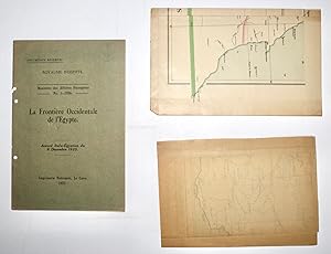
La Frontiere Occidentale de l'Egypte - Accord Italo-Egyptien du 6 Decembre 1925 - Royaume d'Egypte Ministere des Affaires Etrangeres No. 1-1926 (Documents Reserves)
Editore: Imprimerie Nationale, Le Caire, 1927
Libro
Soft cover. Condizione: Fair. Original green printed wraps 17 x 24cm. Printed by the Government Press in 1926 with a run of 450 copies (colophon: 9568-1926-450). 15 + (1)pp (containing Document Nos. 1, 3, 4, 5) + 2 loose colour folding maps (Document Nos. 2, 7). Booklet good, hole-punched to left edge with interiors tanned. Maps good, partially tanned, neatly folded with short tears, and minor loss. Incomplete: document 6 (another map) is not present. This presents the agreement and related correspondence between the Egyptian and Italian governments concerning the border between Libya (Cyrenaica) and Egypt. This border had become contentious when Egypt gained full independence in 1922, although Egypt did not ratify this agreement until 1932-3. Italy had built a fence along much of the frontier in order to control the Senussi. Document 2 (A. Dardano, Cairo, 1925) 38 x 71cm, covers the Libyan Egyptian coast from Cirene to Matruh in the north, to Cufra Oasis in the south on a scale of 1:2,000,000. It shows the routes followed by Hassanein Bey and Rosita Forbes in 1921 and 1923. Document 7 "Map of Egypt" (Survey of Egypt 25/748) 68 x 65cm, has been marked up to compare Egypt's 1925 borders with Libya and Sinai with those assigned by Muhammad Ali. It also shows the positions of the various oases on a scale of 1:2,000,000.