
Importo totale (1 articolo articoli):
Destinazione ordine:

NOLIN, JEAN BAPTISTE (67 risultati)
Vai alla pagina principale dei risultati di ricerca
Tipo di articolo
- Tutti gli articoli
- Libri (44)
- Riviste e Giornali
- Fumetti
- Spartiti
- Arte, Stampe e Poster (9)
- Fotografie
- Mappe (14)
-
Manoscritti e
Collezionismo cartaceo
Condizioni
Legatura
Ulteriori caratteristiche
- Prima edizione (6)
- Copia autografata
- Sovraccoperta
- Con foto (57)
- No print on demand (64)
Spedizione gratuita
Paese del venditore
Valutazione venditore
-
![Immagine del venditore per Uhrsprung der Europaischen Reiche ([ca. 1740]) [LeatherBound] venduto da True World of Books](https://pictures.abebooks.com/inventory/md/md31619198358.jpg)
Uhrsprung der Europaischen Reiche ([ca. 1740]) [LeatherBound]
Data di pubblicazione: 2023
Libro Print on Demand
LeatherBound. Condizione: NEW. LeatherBound edition. Condition: New. Reprinted from [ca. 1740] edition. Leather Binding on Spine and Corners with Golden leaf printing on spine. Bound in genuine leather with Satin ribbon page markers and Spine with raised gilt bands. A perfect gift for your loved ones. NO changes have been made to the original text. This is NOT a retyped or an ocr'd reprint. Illustrations, Index, if any, are included in black and white. Each page is checked manually before printing. As this print on demand book is reprinted from a very old book, there could be some missing or flawed pages, but we always try to make the book as complete as possible. Fold-outs, if any, are not part of the book. If the original book was published in multiple volumes then this reprint is of only one volume, not the whole set. Sewing binding for longer life, where the book block is actually sewn (smythe sewn/section sewn) with thread before binding which results in a more durable type of binding. Pages: 70.
-

Description Du Royaume de France (Histoire) (French Edition)
Editore: Hachette Livre Bnf, 2014
ISBN 10: 201347041XISBN 13: 9782013470414
Libro
Condizione: New.
Ulteriori offerte da altri venditori AbeBooks
Nuovo - A partire da EUR 28,59
-
![Immagine del venditore per Le Champ de Mars dans les Pays-Bas en 1692, ou le roi commande ses armees en personne 1692 [LeatherBound] venduto da True World of Books](https://pictures.abebooks.com/inventory/md/md31617535474.jpg)
Le Champ de Mars dans les Pays-Bas en 1692, ou le roi commande ses armees en personne 1692 [LeatherBound]
Data di pubblicazione: 2023
Libro Print on Demand
LeatherBound. Condizione: New. LeatherBound edition. Condition: New. Reprinted from edition. Leather Binding on Spine and Corners with Golden leaf printing on spine. Bound in genuine leather with Satin ribbon page markers and Spine with raised gilt bands. A perfect gift for your loved ones. NO changes have been made to the original text. This is NOT a retyped or an ocr'd reprint. Illustrations, Index, if any, are included in black and white. Each page is checked manually before printing. As this print on demand book is reprinted from a very old book, there could be some missing or flawed pages, but we always try to make the book as complete as possible. Fold-outs, if any, are not part of the book. If the original book was published in multiple volumes then this reprint is of only one volume, not the whole set. Sewing binding for longer life, where the book block is actually sewn (smythe sewn/section sewn) with thread before binding which results in a more durable type of binding. Pages: 89.
-
![Immagine del venditore per Description du royaume de France, contenant ses principales divisions geographiques dressees pour la grande carte intitulee "le Royaume de France avec ses acquisitions., dediee a Louis le Grand, roy de France et de Navarre, par Jean-Baptiste Nolin". Avec une Table alphabetique de tous les noms qui sont sur cette carte. Par le sieur Tillemon 1693 [LeatherBound] venduto da True World of Books](https://pictures.abebooks.com/inventory/md/md31617537491.jpg)
Description du royaume de France, contenant ses principales divisions geographiques dressees pour la grande carte intitulee "le Royaume de France avec ses acquisitions., dediee a Louis le Grand, roy de France et de Navarre, par Jean-Baptiste Nolin". Avec une Table alphabetique de tous les noms qui sont sur cette carte. Par le sieur Tillemon 1693 [LeatherBound]
Data di pubblicazione: 2023
Libro Print on Demand
LeatherBound. Condizione: New. LeatherBound edition. Condition: New. Reprinted from edition. Leather Binding on Spine and Corners with Golden leaf printing on spine. Bound in genuine leather with Satin ribbon page markers and Spine with raised gilt bands. A perfect gift for your loved ones. NO changes have been made to the original text. This is NOT a retyped or an ocr'd reprint. Illustrations, Index, if any, are included in black and white. Each page is checked manually before printing. As this print on demand book is reprinted from a very old book, there could be some missing or flawed pages, but we always try to make the book as complete as possible. Fold-outs, if any, are not part of the book. If the original book was published in multiple volumes then this reprint is of only one volume, not the whole set. Sewing binding for longer life, where the book block is actually sewn (smythe sewn/section sewn) with thread before binding which results in a more durable type of binding. Pages: 429.
-
![Immagine del venditore per [Portfolio]: Antique Maps of the World in Color venduto da Between the Covers-Rare Books, Inc. ABAA](https://pictures.abebooks.com/inventory/md/md31614799540.jpg)
[Portfolio]: Antique Maps of the World in Color
Editore: Sterling Publishing House, Co., Inc, New York, 1960
Da: Between the Covers-Rare Books, Inc. ABAA, Gloucester City, NJ, U.S.A.
Membro dell'associazione: ABAA ESA ILAB IOBA
Valutazione venditore:

Prima edizione
Unbound. Condizione: Very Good. Portfolio. Color facsimiles of 36 historical maps. Each map measures approximately 12" x 9", printed on 17" x 11˝" paper with descriptive text in the left margin. Housed with a title page sheet and unprinted top sheet in a four-fold chemise. Unprinted topsheet sunned at the edges, first two leaves with some very light toning and a couple of tiny corner creases; the maps are otherwise bright and fine. The chemise is good only with toning, wear, and soil, and a 1" creased tear on the cover panel. A nice production, and the chemise has done its job, keeping the maps bright and fresh.
-
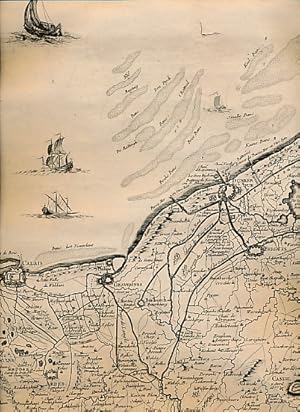
Carte des Pais-Bas. Calais/Dunkerque - Montreuil - Amiens
Editore: [Nolin] [1742], Paris, 1742
Da: Barter Books Ltd, Alnwick, NORTH, Regno Unito
Membro dell'associazione: IOBA
Valutazione venditore:
Prima edizione
Linen backed scroll map. Condizione: G : in good condition. First Edition. 980mm x 300mm (39" x 12"). 1pp. 3 foot map with wooden roller.
-

Carte du royaume d'Angleterre. 260 x 205 mm[
Editore: Paris, Mondhare,, 1791
Da: Finecopy, Westbury, WILTS, Regno Unito
Membro dell'associazione: ABA ILAB PBFA
Valutazione venditore:

Prima edizione
No Binding. Condizione: Near Fine. No Jacket. First Edition. Hand coloured map of the England from Atlas published in France in 1791. Excellent condition with good hand colouring. 260 x 205 mm.
-
![Immagine del venditore per Gouvernement Général Militaire de Bourgogne qui comprend le Duché de Bourgogne, divisé en tous ses Présidiaux et Bailliages et les Provinces de Bresse et de Bugei. [ Carte ] venduto da Librairie du Cardinal](https://pictures.abebooks.com/inventory/md/md2857393025.jpg)
Gouvernement Général Militaire de Bourgogne qui comprend le Duché de Bourgogne, divisé en tous ses Présidiaux et Bailliages et les Provinces de Bresse et de Bugei. [ Carte ]
Editore: Chez Longchamps, 1758
Mappa
souple. Dressé sur les derničres Observations par J. B. Nolin Géographe, gravée par Vallet, carte au format 535 x 650 mm, limites des présidiaux et bailliages rehaussées en couleurs, Chez Longchamps, Paris, 1758 Mouill. et frott. en marge droite. Prix en l'état. Langue: Français.
-
Nouvelle carte d'Europe divisée en ses Empires et Royaumes pour l'instruction de la Jeneusse
Editore: Chez JEAN, A Paris, 1818
53 x 73 cm. Mapa entelado y plegado. Cubiertas cartón forrado con papel de aguas época. Excelente estado. Nuevo mapa de Europa dividido en sus imperios y reinos. Color. En espańol. Book in spanish. El pago contrarrembolso lleva un recargo de 3,25 euros.
-

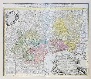
Le Gouvernement General de Languedoc divisé en trois Lieutenances generales.
Editore: Nolin, s.d., Parigi,
Da: La Darsena di Leonelli Siro e C. s.a.s., Modena, MO, Italia
Membro dell'associazione: ALAI ILAB
Valutazione venditore:

Acquaforte, lastra mm. 465 x 630. Completa dell'impronta del rame piů piccoli margini. Un cartiglio con le Armi del Cardinale De Bosny e un cartiglio con tutte le armi delle principali Cittŕ rappresentate. Un lieve alone all'angolo superiore destro, per il resto ottima impressione in acquarellatura coeva.
-
Gubernatio Generalis Languedociae Occitania olim dictae. / Le Gouvernement General de Languedoc" - Languedoc-Roussillon Toulouse Montpellier Narbonne Perpignan carte Homann
Editore: Nürnberg, Homann Erben, 1742
Da: Antiquariat Steffen Völkel GmbH, Seubersdorf, Germania
Membro dell'associazione: ILAB VDA
Valutazione venditore:
Mappa
prächtige altkolorierte Original Kupferstich-Karte vonHomann von ca. 1740 Blattmasse ca.55 x63 cm gut erhalten Original! - Kein Nachdruck! - Keine Kopie! Sprache: Französisch.
-
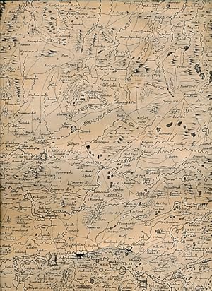
Carte des Pais-Bas. Herentals - Tirlemont - Sedan. Lyndhoven -Maestricht - Arlon
Editore: [Nolin] [1742], Paris, 1742
Da: Barter Books Ltd, Alnwick, NORTH, Regno Unito
Membro dell'associazione: IOBA
Valutazione venditore:
Prima edizione
Linen backed scroll maps. Condizione: G: in overall good condition. First Edition. 980mm x 300mm (39" x 12"). 2pp. A pair of 3 foot matching scroll maps with wooden rollers.
-
Le Duché de Mantoue.
Editore: Cartografia, Lombardia - Mantova
Raffigurazione cartografica del territorio del Ducato di Mantova. Il titolo č iscritto in decorativo drappo nell'angolo in basso a destra. Coloritura coeva dei confini. Restauro in basso lungo la piega centrale. Piega editoriale centrale.
-
Carte Generale du Theatre de la Guerre en Italie ou sont marquées toutes les routes.
Editore: Italia
Carta dell'Italia settentrionale e parte di quella meridionale in cui sono segnate le strade che si potevano percorrere per giungere da Parigi o Vienna alle principali cittŕ della nostra penisola. Coloritura coeva. Buona conservazione. Piega editoriale centrale. Riferimenti: Davoli, San Felici "Terre di Langobardia.", p. 87, n° 34.
-
La partie occidentale de l'Allemagne avec les pays adjacents, le long du Rhein et des rivičres qui s'y rendent.
Editore: 0
Libro
Dimension extérieur : 49,5 x 71,5 cm. Image : 39,5 x 64 cm. Trčs jolie carte représentant une partie de l'Allemagne et des Pays-bas ouů de la France par exemple, il s'agit du Saint-empire romain germanique. Editée en 1690. En bon état général, envoi soigné. Français Tirée des mémoires de Cantel et de plusieurs autres. Corrigée et augmentée par M. Le prieur du Nufmarche. Dédiée ŕ Monseigneur de Harley, seigneur de Bonnevil, conseiller ordinaire du Roy en ses conseils d'Etat et privé. Par son trčs humble et obéissant serviteur. Chez Jean-Baptiste Nolin sur le quai de l'horloge du palais proche de la rue de harley ŕ l'enseigne de la place des victoires. Jean-Baptiste Nolin (1657-1708) est un cartographe, graveur, éditeur et marchand de cartes français.
-
Carte generale du theatre de la guerre en Italie .
Editore: Italia
-
Le Comté et gouvernement de Provence avec les terres adjacentes
Editore: Paris
Carte de la Provence, depuis le sud du Dauphiné jusqu'ŕ la mer Méditerranée, avec le comté de Nice ŕ l'est. Elle est ornée d'un grand cartouche de titre portant les armoiries des villes et porte, dans un encart, le détail de l'embouchure du Rhône et de la Camargue.Retirage par Nolin en 1742 de la carte de Tillemon publiée en 1707 chez son pčre Jean Baptiste Nolin I. Carte anciennement numérotée 22 ŕ l'encre au verso. // ENGLISH // Map of Provence, from the south of the Dauphiné to the Mediterranean Sea, with the county of Nice to the east. It is decorated with a large title cartouche bearing the coats of arms of the cities and carries, in an inset, the detail of the mouth of the Rhone and the Camargue.Removed by Nolin in 1742 from the map of Tillemon published in 1707 by his father Jean Baptiste Nolin I. Map formerly numbered 22 in ink on the reverse.
-
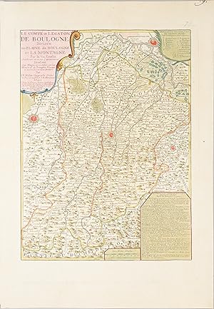
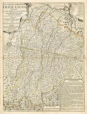
Le Comté et Legaton de Boulogne divisée en plaine de Boulogne et la montagne par Via Emelia [The County and Embassy of Bologna divided between the lowlands and the mountains by the Via Aemelia]
Data di pubblicazione: 1730
Mappa
Condizione: Very Good. 'Le Comté et Legaton de Boulogne'. Bologna Modena Imola Ferrara. NOLIN c1730 map. Antique 18th century atlas map, printed on thick, good quality paper with original outline hand colour/color and decorative title cartouche; Jean Baptiste Nolin (c1730). 43.0 x 32.0cm, 16.75 x 12.75 inches. Condition: Very Good. Please contact us if you would like to arrange to view this map. There is nothing printed on the reverse side, which is plain. This eighteenth century map of "The County and Embassy of Bologna", part of Emilia Romagna, is centred on the city of Bologna. The Via Aemelia runs at an angle across the centre of the map. The fortified cities of Modena, Imola and Ferrara are marked.
-
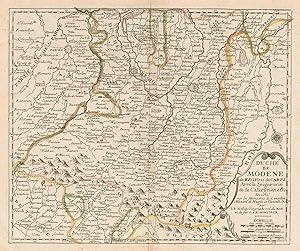
Duché de Modene de Regio et de Carpi avec la Seigneurie de la Cafargnana &c [Duchy of Modena and Reggio, with Carpi, and the Lordship of Cafargnana &c]
Data di pubblicazione: 1725
Mappa
Condizione: Very Good. 'Duché de Modene de Regio et de Carpi' Duchy of Modena & Reggio. NOLIN c1725 map. Antique 18th century atlas map, printed on thick, good quality paper with original outline hand colour/color ; Jean Baptiste Nolin (c1725). 26.0 x 30.5cm, 10 x 12 inches. Condition: Very Good. Please contact us if you would like to arrange to view this map. There is nothing printed on the reverse side, which is plain. The fortified towns of Modena, Parma, Reggio Emilia, Bologna & Brescello are shown prominently on t his eighteenth century map.
-
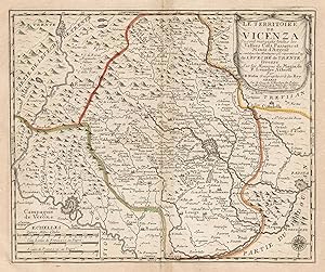
Territoire de Vicenza ou sont marquées toutes les Valles Cols Passage et Mines d'Argent.
Editore: Veneto - Vicenza
Raffigurazione del territorio vicentino. Nell'angolo in alto a destra in decorativo cartiglio a drappo č riportato il titolo della carta. E' interessante rilevare che contrariamente a qianto dichiarato nel titolo "Ou sont marquées toutes les Vallees Cols Passages et Mines d'Argent" queste ultime sembra non siano segnalatePiega centrale editoriale. Riferimenti: "Vicenza Cittŕ Bellissima Iconografia vicentina a stampa dal XV al XIX secolo", n° 12.
-
gut erhaltenes Blatt Sprache: Deutsch Gewicht in Gramm: 550.
-
Le Comté et Legation de Boulogne Divisée en Plaine de Boulogne et la Montagne par la Via Emilia.
Editore: Emilia Romagna - Bologna - Modena - Reggio
Raffigurazione del territorio bolognese. In alto sulla sinistra, entro decorativo cartiglio, viene riportato il titolo della carta in cui sono dichiarate le fonti da cui l'autore ha preso spunto. Nell'angolo in alto a destra si trova la legenda mentre nell'angolo in basso a destra in semplice riquadro viene riportata la descrzione del territorio corredata da alcuni dati statistici. Coloritura coeva dei confini. Piega editoriale centrale.
-
L'Etat du Duc de Parme Contenant Les Duchés de Parme et Plaisance et les Etats Palavicin et de Landi .
Editore: Paris
Condizione: Trčs bon. Élégante carte réunissant les duchés de Parme, de Plaisance et les états Palavicin et de Landi appartenant au Duc de Parme.Le titre figure dans un élégant cartouche orné des armoiries du Duc de Parme. Texte descriptif des Etats dans les coins inférieurs gauche et droit. Pastoureau, NOLIN II B // ENGLISH // Elegant map uniting the duchies of Parma, Piacenza and the Palavicin and Landi states belonging to the Duke of Parma.The title appears in an elegant cartouche decorated with the coat of arms of the Duke of Parma. Descriptive text of the states in the lower left and right corners. Pastoureau, NOLIN II B.
-
Duché de Modene de Regio et de Carpi.
Editore: Emilia Romagna - Modena - Reggio Emilia
Piega editoriale centrale. Riferimenti: Davoli, San Felici "Terre di Langobardia.", p. 246, n° 117.
-
Les vallées du Piemont habitees par les Vaudois ou Barbets [The valleys of Piedmont (or Waldenses) inhabited by the Waldensians (or Vallenses, Valdesi)]
Data di pubblicazione: 1740
Mappa
Condizione: Very Good. 'Les vallées du Piemont habitees par les Vaudois'. Piemonte. NOLIN c1740 map. Antique 18th century atlas map, printed on thick, good quality paper with original outline hand colour/color and decorative title cartouche; Jean Baptiste Nolin (c1740). 34.0 x 27.0cm, 13.5 x 10.75 inches. Condition: Very Good. Please contact us if you would like to arrange to view this map. There is nothing printed on the reverse side, which is plain. The map shows the Waldensian valleys of the River Po and its tributaries in western Piedmont. The Waldensians are a members of a Protestant Christian Calvinist movement which has been centred in and around these valleys since medieval times. The map shows the Chisone and Pellice river valleys and the source of the Po itself. Places named on the map include the following (spelling and/or language may differ from the modern accepted form): Pinerolo, Pragelato, Perosa, Bobbio Pellice, Torre Pellice, Villafranca, Saluzzo, Refreddo.
-
Les Suisses, Leurs Alliez,.
Editore: Artist: Nolin Jean Baptiste ( - 1725 ) Paris ; ca: 1689; - Jean-Baptiste Nolin (ca 1657-1708) set up the family publishing business in Paris Many of his maps were based on the work of Vincenzo Coronelli and Sieur de Tillemon His son (1686-1762) continued the business for many years and prepared an Atlas General which was published posthumously in 1783, 1657
Da: Antique Sommer& Sapunaru KG, München, Germania
Membro dell'associazione: ILAB VDA
Valutazione venditore:
Technic: Copper print; colorit: original colored; condition: Restoration at centerfold, size (in cm): 46 x 58,5 cm; - Very nice old coloured map of Switzerland divided into its cantons. It contains the information from the maps of Hans Conrad Gyger and Josias Simmler. Three cartouches including a title cartouche, an index and a description explaining the geographical division of Switzerland.
-
Le comté et legation de Boulogne divisée en plaine de Boulogne et la Montagne par la Via Emelia subdivisé en trois Capitaineries dressée sur Magin et rectifiée sur les Memoires de Pompeio Vizani et autres Nouveaux Auteurs. Par I.B. Nolin Geographe Ordin
Editore: la Veuve Nolin, Paris, 1708
Condizione: Trčs bon. Cette carte présente le comté de Boulogne et les principales villes traversées par la Via Emelia. On peut y voir une partie du Duché de Modene, la Plaine et la Montagne de Bologne, une partie du Duché de Ferrare nord et du Duché de Florence au sud. Le titre, l'échelle, une description ainis qu'une explication sont inscrits dans quatre cartouches décorés.La via Aemilia, ou voie Émilienne est une route romaine construite au IIe sičcle av. J.-C. par le consul romain Marcus Aemilius Lepidus. Elle relie en ligne droite Plaisance ŕ Rimini, en traversant de nombreuses villes de l'Émilie-Romagne (région composée de l'Émilie et de la Romagne), région ŕ laquelle elle donna son nom. // ENGLISH // Copper-engraved map. Condition: very good, original colour. Attractive map of the county of Boulogne. Beautiful map in original colour which presents the county of Boulogne and the main towns crossed by the Via Emelia. You can see part of the Duchy of Modena, the Plain and the Mountain of Bologna, part of the Duchy of Ferrara to the north and the Duchy of Florence to the south. The title, the scale, a description and an explanation are inscribed in four decorated cartouches. The via Aemilia, or Emilian Way, is a Roman road built in the 2nd century BC by the Roman consul Marcus Aemilius Lepidus. It connects Piacenza to Rimini in a straight line, passing through many towns in Emilia-Romagna (a region composed of Emilia and Romagna), the area to which it gave its name.
-

Le comté et legation de Boulogne divisée en plaine de Boulogne et la Montagne par la Via Emelia subdivisé en trois .
Editore: Paris
Condizione: Trčs bon. Cette carte présente le comté de Boulogne et les principales villes traversées par la Via Emelia. On peut y voir une partie du Duché de Modene, la Plaine et la Montagne de Bologne, une partie du Duché de Ferrare nord et du Duché de Florence au sud. Le titre, l'échelle, une description ainis qu'une explication sont inscrits dans quatre cartouches décorés.La via Aemilia, ou voie Émilienne est une route romaine construite au IIe sičcle av. J.-C. par le consul romain Marcus Aemilius Lepidus. Elle relie en ligne droite Plaisance ŕ Rimini, en traversant de nombreuses villes de l'Émilie-Romagne (région composée de l'Émilie et de la Romagne), région ŕ laquelle elle donna son nom. // ENGLISH // Cette carte présente le comté de Boulogne et les principales villes traversées par la Via Emelia. On peut y voir une partie du Duché de Modene, la Plaine et la Montagne de Bologne, une partie du Duché de Ferrare nord et du Duché de Florence au sud. Le titre, l'échelle, une description ainis qu'une explication sont inscrits dans quatre cartouches décorés.La via Aemilia, ou voie Émilienne est une route romaine construite au IIe sičcle av. J.-C. par le consul romain Marcus Aemilius Lepidus. Elle relie en ligne droite Plaisance ŕ Rimini, en traversant de nombreuses villes de l'Émilie-Romagne (région composée de l'Émilie et de la Romagne), région ŕ laquelle elle donna son nom.
-
Le royaume d'Angleterre divisČ en plusieurs parties subdivisČes en Comtez ou Shireries.
Editore: sur le Quay de l'horloge, Parigi, 1690
Da: libreria antiquaria perini Sas di Perini, Verona, VR, Italia
Membro dell'associazione: ALAI ILAB
Valutazione venditore:
Arte / Stampa / Poster
Copper engraving, mm 450x600, outline original colour. Attractive and uncommon map with a large cartouches in top right corner, an inset map with Guernsey and Jersey islands at bottom. List of Counties at left. Good condition with a restored tear in right top corner. Nr.cat: Cod. 1994.
-
L'Etat de Milan divisé en ses Principales Parties.
Editore: Lombardia - Milano
Carta geografica dello Stato di Milano e dei territori confinanti. Il titolo č riportato in ricco e decorativo cartiglio. Oltre allo Stato di Milano sono raffigurati anche i territori dello Stato di Venezia in particolare il Bergamasco ed il Bresciano e poi i Ducati di Parma. Modena e Mantova. Coloritura coeva dei confini. Pieghe editoriali.


![Immagine del venditore per Le Comté et Legaton de Boulogne divisée en plaine de Boulogne et la montagne par Via Emelia [The County and Embassy of Bologna divided between the lowlands and the mountains by the Via Aemelia] venduto da Antiqua Print Gallery](https://pictures.abebooks.com/inventory/md/md31102182994.jpg)
![Immagine del venditore per Duché de Modene de Regio et de Carpi avec la Seigneurie de la Cafargnana &c [Duchy of Modena and Reggio, with Carpi, and the Lordship of Cafargnana &c] venduto da Antiqua Print Gallery](https://pictures.abebooks.com/inventory/md/md31102180033.jpg)
![Immagine del venditore per Les vallées du Piemont habitees par les Vaudois ou Barbets [The valleys of Piedmont (or Waldenses) inhabited by the Waldensians (or Vallenses, Valdesi)] venduto da Antiqua Print Gallery](https://pictures.abebooks.com/inventory/md/md31102180032.jpg)
