Importo totale (1 articolo articoli):
Destinazione ordine:

WILLEM JANSZOON BLAEU 1571 1638 (163 risultati)
Vai alla pagina principale dei risultati di ricerca
Tipo di articolo
- Tutti gli articoli
- Libri (118)
- Riviste e Giornali
- Fumetti
- Spartiti
- Arte, Stampe e Poster (15)
- Fotografie
- Mappe (30)
-
Manoscritti e
Collezionismo cartaceo
Condizioni
- Tutte
- Nuovi
- Antichi o usati
Legatura
- Tutte
- Rilegato
- Brossura (2)
Ulteriori caratteristiche
- Prima edizione (1)
- Copia autografata
- Sovraccoperta
- Con foto (153)
- No print on demand
Spedizione gratuita
Paese del venditore
Valutazione venditore
-
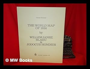
The World Map of 1624 / by Willem Jansz. Blaeu and Jodocus Hondius ; Gunter Schilder
Editore: Amsterdam : N. Israel, 1977
ISBN 10: 9060721187ISBN 13: 9789060721186
Libro
1st Edition in this form. Fine paperback copy. Particularly and surprisingly well-preserved; tight, bright, clean and especially sharp-cornered.; 8vo 8" - 9" tall; 0 pages; Description: 17 leaves, A-V leaves of plates : ill., maps ; 56 cm. Includes bibliographical references. Reprint of the 1624 map by W. J. Blaeu, as revised and published by J. Hondius, Amsterdam. Title of original map reads: Nova universi terrarum orbis mappa. Series: Wall-maps of the 16th and 17th centuries ; 1. Subjects: World maps --Early works to 1800 --Early maps. 3 Kg.
Ulteriori offerte da altri venditori AbeBooks
Usato - A partire da EUR 45,00
-
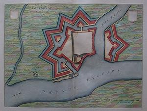
Kein Einband. Condizione: Sehr gut. Es handelt sich hierbei um einen originalen, kolorierten Kupferstichplan der Befestigungsanlagen der Gemeinde Duisburg-Ruhrort von Willem Janszoon Blaeu (1571 - 1638) aus dem Jahr 1649. *** Titel: Roeroordt *** Gebiet bzw. Ort: Duisburg-Ruhrort *** Kartograph: Willem Janszoon Blaeu (1571 - 1638) *** Jahr: 1649 *** Größe des Plattenbereichs: 37 x 50 cm *** Technik: Kupferstich *** Zustand (Perfekt/ Sehr gut/ Gut/ Ordentlich/ Mäßig/ Schlecht): In sehr gutem Erhaltungszustand *** Bemerkungen: Plan der Befestigungsanlagen und der Umgebung - - - International buyers welcome. If you have any questions, please don't hesitate to ask. --- Auf Wunsch stellen wir Ihnen gerne ein kostenfreies Echtheitszertifikat aus --- If you wish, we will gladly provide a certificate of authenticity free of charge ---.
-
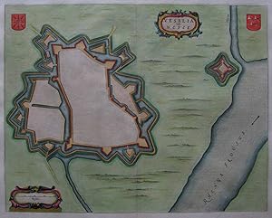
Kein Einband. Condizione: Gut bis sehr gut. Es handelt sich hierbei um einen originalen, kolorierten Kupferstichplan der Befestigungsanlagen der Stadt Rheinberg von Willem Janszoon Blaeu (1571 - 1638) aus dem Jahr 1649. *** Titel: Rheno Berka *** Gebiet bzw. Ort: Rheinberg *** Kartograph: Willem Janszoon Blaeu (1571 - 1638) *** Jahr: 1649 *** Größe des Plattenbereichs: 37 x 52 cm *** Technik: Kupferstich *** Zustand (Perfekt/ Sehr gut/ Gut/ Ordentlich/ Mäßig/ Schlecht): In gutem Erhaltungszustand. Mittelfalte hinterlegt. *** Bemerkungen: Plan der Befestigungsanlagen und der Umgebung - - - International buyers welcome. If you have any questions, please don't hesitate to ask. --- Auf Wunsch stellen wir Ihnen gerne ein kostenfreies Echtheitszertifikat aus --- If you wish, we will gladly provide a certificate of authenticity free of charge ---.
-
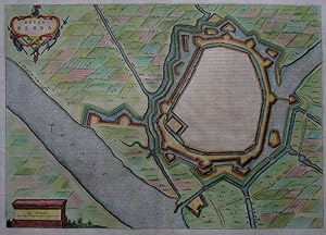
Kein Einband. Condizione: Sehr gut. Es handelt sich hierbei um einen originalen, kolorierten Kupferstichplan der Befestigungsanlagen der Stadt Wesel von Willem Janszoon Blaeu (1571 - 1638) aus dem Jahr 1649. *** Titel: Vesalia vulgo Wesel *** Gebiet bzw. Ort: Wesel *** Kartograph: Willem Janszoon Blaeu (1571 - 1638) *** Jahr: 1649 *** Größe des Plattenbereichs: 41 x 52 cm *** Technik: Kupferstich *** Zustand (Perfekt/ Sehr gut/ Gut/ Ordentlich/ Mäßig/ Schlecht): In sehr gutem Erhaltungszustand *** Bemerkungen: Plan der Befestigungsanlagen und der Umgebung - - - International buyers welcome. If you have any questions, please don't hesitate to ask. --- Auf Wunsch stellen wir Ihnen gerne ein kostenfreies Echtheitszertifikat aus --- If you wish, we will gladly provide a certificate of authenticity free of charge ---.
-
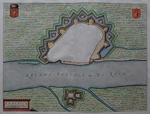
Kein Einband. Condizione: Gut. Es handelt sich hierbei um einen originalen, kolorierten Kupferstichplan der Umgebung der Stadt Emmerich von Willem Janszoon Blaeu (1571 - 1638) aus dem Jahr 1649. *** Titel: Emmeryck *** Gebiet bzw. Ort: Emmerich *** Kartograph: Willem Janszoon Blaeu (1571 - 1638) *** Jahr: 1649 *** Größe des Plattenbereichs: 39 x 51 cm *** Technik: Kupferstich *** Zustand (Perfekt/ Sehr gut/ Gut/ Ordentlich/ Mäßig/ Schlecht): In gutem Erhaltungszustand. Am Rand leicht gebräunt. *** Bemerkungen: Plan der Befestigungsanlagen und der Umgebung - - - International buyers welcome. If you have any questions, please don't hesitate to ask. --- Auf Wunsch stellen wir Ihnen gerne ein kostenfreies Echtheitszertifikat aus --- If you wish, we will gladly provide a certificate of authenticity free of charge ---.
-
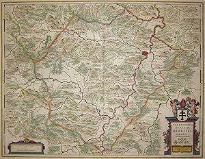
Kein Einband. Condizione: Gut. Es handelt sich hierbei um eine originale, kolorierte Kupferstich-Landkarte des Gebiets des Bezirks Hersfeld und des Fuldatals von Willem Janszoon Blaeu (1571 - 1638) aus dem Jahr 1640. *** Titel: Territorium Abbatiae Heresfeldensis. 't Stift Hirszfeldt *** Gebiet bzw. Ort: Bezirk Hersfeld, Fuldatal *** Kartograph: Willem Janszoon Blaeu (1571 - 1638) *** Jahr: 1640 *** Größe des Plattenbereichs: 38 x 50 cm *** Technik: Kupferstich *** Zustand (Perfekt/ Sehr gut/ Gut/ Ordentlich/ Mäßig/ Schlecht): In gutem Erhaltungszustand *** Bemerkungen: Weitere Fotos stelle ich bei Interesse gerne zur Verfügung. - - - International buyers welcome. If you have any questions, please don't hesitate to ask. --- Auf Wunsch stellen wir Ihnen gerne ein kostenfreies Echtheitszertifikat aus --- If you wish, we will gladly provide a certificate of authenticity free of charge ---.
-
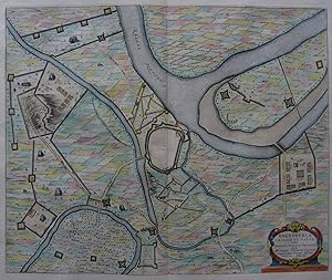
Rhenoberca Obsessa et Capta Armis Ordinum Belgicae Foederatae . Anno 1601
Data di pubblicazione: 1649
Arte / Stampa / Poster
Kein Einband. Condizione: Sehr gut. Es handelt sich hierbei um einen originalen, kolorierten Kupferstichplan der Befestigungsanlagen der Stadt Rheinbach von Willem Janszoon Blaeu (1571 - 1638) aus dem Jahr 1649. *** Titel: Rhenoberca Obsessa et Capta Armis Ordinum Belgicae Foederatae . Anno 1601. *** Gebiet bzw. Ort: Rheinberg *** Kartograph: Willem Janszoon Blaeu (1571 - 1638) *** Jahr: 1649 *** Größe des Plattenbereichs: 45 x 55 cm *** Technik: Kupferstich *** Zustand (Perfekt/ Sehr gut/ Gut/ Ordentlich/ Mäßig/ Schlecht): In sehr gutem Erhaltungszustand *** Bemerkungen: Plan der Befestigungsanlagen und der Umgebung mit feindlichen Truppen - - - International buyers welcome. If you have any questions, please don't hesitate to ask. --- Auf Wunsch stellen wir Ihnen gerne ein kostenfreies Echtheitszertifikat aus --- If you wish, we will gladly provide a certificate of authenticity free of charge ---.
-
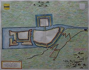
Kein Einband. Condizione: Sehr gut. Es handelt sich hierbei um eine originale, kolorierte Kupferstich-Ansicht der Befestigungsanlagen der Stadt Moers von Willem Janszoon Blaeu (1571 - 1638) aus dem Jahr 1649. *** Titel: Meursae Obsidio *** Gebiet bzw. Ort: Moers am Niederrhein *** Kartograph: Willem Janszoon Blaeu (1571 - 1638) *** Jahr: 1649 *** Größe des Plattenbereichs: 37 x 49 cm *** Technik: Kupferstich *** Zustand (Perfekt/ Sehr gut/ Gut/ Ordentlich/ Mäßig/ Schlecht): In sehr gutem Erhaltungszustand *** Bemerkungen: Plan der Befestigungsanlagen und der Umgebung mit feindlichen Truppen aus der Vogelschau. - - - International buyers welcome. If you have any questions, please don't hesitate to ask. --- Auf Wunsch stellen wir Ihnen gerne ein kostenfreies Echtheitszertifikat aus --- If you wish, we will gladly provide a certificate of authenticity free of charge ---.
-
Kein Einband. Condizione: Gut. Es handelt sich hierbei um eine originale, kolorierte Kupferstich-Landkarte des Gebiets des Erzbistums Köln von Willem Janszoon Blaeu (1571 - 1638) aus dem Jahr 1640. *** Titel: Coloniensis Archiepiscopatus *** Gebiet bzw. Ort: Erzbistum Köln *** Kartograph: Willem Janszoon Blaeu (1571 - 1638) nach Gigas *** Jahr: 1640 *** Größe des Plattenbereichs: 38 x 50 cm *** Technik: Kupferstich *** Zustand (Perfekt/ Sehr gut/ Gut/ Ordentlich/ Mäßig/ Schlecht): In gutem Erhaltungszustand *** Bemerkungen: Mittelfalte hinterlegt. Leicht gebräunt. - - - International buyers welcome. If you have any questions, please don't hesitate to ask. --- Auf Wunsch stellen wir Ihnen gerne ein kostenfreies Echtheitszertifikat aus --- If you wish, we will gladly provide a certificate of authenticity free of charge ---.
-
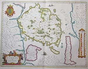
Kein Einband. Condizione: Sehr gut. Es handelt sich hierbei um eine originale, kolorierte Kupferstich-Landkarte Fünens von Willem Janszoon Blaeu (1571 - 1638) aus dem Jahr 1640. *** Titel: Fionia vulgo Funen *** Gebiet bzw. Ort: Fünen (Dänemark) *** Kartograph: Willem Janszoon Blaeu (1571 - 1638) *** Jahr: 1640 *** Größe des Plattenbereichs: 38 x 50 cm *** Technik: Kupferstich *** Zustand (Perfekt/ Sehr gut/ Gut/ Ordentlich/ Mäßig/ Schlecht): In sehr gutem Erhaltungszustand *** Bemerkungen: - - - International buyers welcome. If you have any questions, please don't hesitate to ask. --- Auf Wunsch stellen wir Ihnen gerne ein kostenfreies Echtheitszertifikat aus --- If you wish, we will gladly provide a certificate of authenticity free of charge ---.
-
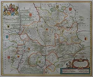
Kein Einband. Condizione: Gut bis sehr gut. Es handelt sich hierbei um eine originale, kolorierte Kupferstich-Landkarte des Gebietes des Bistums Hildesheim von Joannes Gigas bei Willem Janszoon Blaeu (1571 - 1638), ca. aus dem Jahr 1640. *** Titel: Episcopatus Hildesiensis Descriptio Novissima *** Gebiet bzw. Ort: Bistum Hildesheim *** Kartograph: Joannes Gigas bei Willem Janszoon Blaeu (1571 - 1638) *** Jahr: 1640 *** Größe des Plattenbereichs: 41 x 50 cm *** Technik: Kupferstich *** Zustand (Perfekt/ Sehr gut/ Gut/ Ordentlich/ Mäßig/ Schlecht): In sehr gutem Erhaltungszustand *** Bemerkungen: Leichte Knickspur oben links. - - - International buyers welcome. If you have any questions, please don't hesitate to ask. --- Auf Wunsch stellen wir Ihnen gerne ein kostenfreies Echtheitszertifikat aus --- If you wish, we will gladly provide a certificate of authenticity free of charge ---.
-
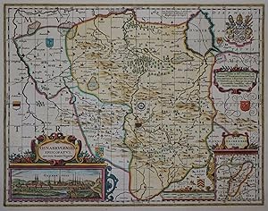
Kein Einband. Condizione: Gut. Es handelt sich hierbei um eine originale, kolorierte Kupferstichlandkarte des Bistums Osnabrück von Valk & Schenk, um das Jahr 1700. *** Titel: Osnabrugensis Episcopatus. Auctore Ioanne Gigante Ort: Bistum Osnabrück *** Kartograph: Pieter Schenk (1660 - 1711) und Gerard Valk (1652 - 1726) nach Willem Janszoon Blaeu (1571 - 1638) *** Jahr: ca. 1700 *** Größe des Plattenbereichs: 37 x 48 cm *** Technik: Kupferstich Zustand (Perfekt/ Sehr gut/ Gut/ Ordentlich/ Mäßig/ Schlecht): In gutem Erhaltungszustand. Mittelfalte hinterlegt. *** Bemerkungen: Aktualisierte Ausgabe der von Blaeu um 1640 veröffentlichten Karte. - - - International buyers welcome. If you have any questions, please don't hesitate to ask. --- Auf Wunsch stellen wir Ihnen gerne ein kostenfreies Echtheitszertifikat aus --- If you wish, we will gladly provide a certificate of authenticity free of charge ---.
-
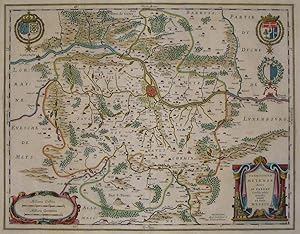
Territorium Metense Auctore Ab. Fabert Consule urbis Metensis. Le Pais Messin
Data di pubblicazione: 1635
Mappa
Kein Einband. Condizione: Gut. Es handelt sich hierbei um eine originale, kolorierte Kupferstich-Landkarte des Gebiets von Metz von Willem Janszoon Blaeu (1571 - 1638) aus dem Jahr 1635. *** Titel: Territorium Metense Auctore Ab. Fabert Consule urbis Metensis. Le Pais Messin *** Gebiet bzw. Ort: Metz in Frankreich *** Kartograph: Willem Janszoon Blaeu (1571 - 1638) *** Jahr: 1635 *** Größe des Plattenbereichs: 39 x 50 cm *** Technik: Kupferstich *** Zustand (Perfekt/ Sehr gut/ Gut/ Ordentlich/ Mäßig/ Schlecht): In gutem Erhaltungszustand *** Bemerkungen: Mittelfalte hinterlegt, 2 kleine hinterlegte Randeinrisse. - - - International buyers welcome. If you have any questions, please don't hesitate to ask. --- Auf Wunsch stellen wir Ihnen gerne ein kostenfreies Echtheitszertifikat aus --- If you wish, we will gladly provide a certificate of authenticity free of charge ---.
-
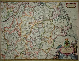
Kein Einband. Condizione: Gut. Es handelt sich hierbei um eine originale, altkolorierte Kupferstich-Landkarte des Westfälischen Kreises von Willem Janszoon Blaeu (1571 - 1638) ca. aus dem Jahr 1640. *** Titel: Circulus Westphalicus, sive Germaniae Inferioris *** Gebiet bzw. Ort: Westfälischer Kreis mit den Gebieten Nordsee, Weserlauf, Rheinlauf und Bonn / Münden *** Kartograph: Willem Janszoon Blaeu (1571 - 1638) *** Jahr: um 1640 *** Größe des Plattenbereichs: 41 x 53 cm *** Technik: Kupferstich *** Zustand (Perfekt/ Sehr gut/ Gut/ Ordentlich/ Mäßig/ Schlecht): In gutem Erhaltungszustand. Kleiner, hinterlegter Randeinriß unten neben der Bugfalte. Insgesamt gleichmäßig gebräunt. *** Bemerkungen: Eine sehr dekorative, altkolorierte Karte des Westfälischen Kreises mit den Gebieten Nordsee, Weserlauf, Rheinlauf und Bonn / Münden. Die Grenzen der westorientierten Karte liegen auf einer Linie Nijmegen - Venlo im Westen, Bonn im Süden und der Weser im Osten. Hamburg wird auf einer kleinen Insetkarte in der Kartusche dargestellt. - - - International buyers welcome. If you have any questions, please don't hesitate to ask. --- Auf Wunsch stellen wir Ihnen gerne ein kostenfreies Echtheitszertifikat aus --- If you wish, we will gladly provide a certificate of authenticity free of charge ---.
-
Kein Einband. Condizione: Sehr gut. Es handelt sich hierbei um eine originale, kolorierte Kupferstich-Ansicht der Umgebung der Stadt Rheinbach von Willem Janszoon Blaeu (1571 - 1638) aus dem Jahr 1649. *** Titel: Obsidio Rhinbergcae *** Gebiet bzw. Ort: Rheinberg *** Kartograph: Willem Janszoon Blaeu (1571 - 1638) *** Jahr: 1649 *** Größe des Plattenbereichs: 47 x 55 cm *** Technik: Kupferstich *** Zustand (Perfekt/ Sehr gut/ Gut/ Ordentlich/ Mäßig/ Schlecht): In sehr gutem Erhaltungszustand *** Bemerkungen: Plan der Stadt, der Befestigungsanlagen und der Umgebung - - - International buyers welcome. If you have any questions, please don't hesitate to ask. --- Auf Wunsch stellen wir Ihnen gerne ein kostenfreies Echtheitszertifikat aus --- If you wish, we will gladly provide a certificate of authenticity free of charge ---.
-

Pedemontana Regio cum Genvensivm territorio et Montisferrati Marchionatu
Editore: Amsterdam, c.ca 1630, 1630
Da: TABERNA LIBRARIA - ALAI - ILAB, Pistoia, Italia
Membro dell'associazione: ALAI ILAB
Valutazione venditore:

Acquaforte su rame con bella coloritura settecentesca, mm. 362x460 alla battuta piů ampi marg. bianchi. Sul verso descrizione della carta in latino. Carta geografica tratta dal "Appendix Teatri A. Ortelii et Atlantis G. Mercatoris continens Tabvlas Geographicas " Ottima conservaz.
-
Corsica Insula
Editore: c.1640, Amsterdam, 1640
Da: Alexandre Antique Prints, Maps & Books, Toronto, ON, Canada
Membro dell'associazione: ABAC ILAB
Valutazione venditore:

Mappa
Condizione: Very Good. Map of CorsicaLatin text., Size : 180x240 (mm), 7.09x9.45 (Inches), Hand Colored, 0.
-
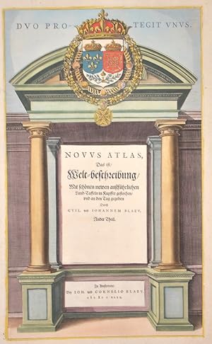
Duo Protegit unus. Novus Atlas, Das ist Welt-beschreibung Mit schönen newen ausführlichen Land-Taffeln in Kupffer gestochen und an den Tag gegeben.
Editore: Artist: Blaeu Willem Janszoon ( - 1638 ) Amsterdam ; issued in: Amsterdam ; ca: 1642; - Joan Guilliemus Blaeu was the eldest son of Willem Janszoon Blaeu (1571-1638) and was probably born in Alkmaar in the province of Noord-Holland in the final years of the 16th century He was brought up in Amsterdam and studied law at the University of Leiden before going into partnership with his father in the 1630s Although his father Willem had cartographic interests having studied under the Danish astronomer Tycho Brahe and having manufactured globes and instruments his primary business was as a printer It was under the control of Joan that the Blaeu printing press achieved lasting fame by moving towards the printing of maps and expanding to become the, 1571
Da: Antique Sommer& Sapunaru KG, München, Germania
Membro dell'associazione: ILAB VDA
Valutazione venditore:
Arte / Stampa / Poster
Technic: Copper print; colorit: original colored; condition: Perfect condition, size (in cm): 41 x 24,5 cm; - Title page "Duo Protegit unus" from the Blaeu Atlas Novus Atlas, Das ist Welt-beschreibung. edited by Joan and Cornelius Blaeu, author Willem Blaeu.; - Special feature: German edition.
-
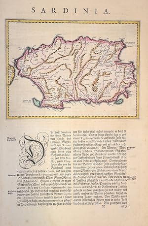
Sardinia.
Editore: Artist: Blaeu Willem Janszoon ( - 1638 ) Amsterdam ; issued in: Amsterdam ; ca: 1640; - Joan Guilliemus Blaeu was the eldest son of Willem Janszoon Blaeu (1571-1638) and was probably born in Alkmaar in the province of Noord-Holland in the final years of the 16th century He was brought up in Amsterdam and studied law at the University of Leiden before going into partnership with his father in the 1630s Although his father Willem had cartographic interests having studied under the Danish astronomer Tycho Brahe and having manufactured globes and instruments his primary business was as a printer It was under the control of Joan that the Blaeu printing press achieved lasting fame by moving towards the printing of maps and expanding to become the, 1571
Da: Antique Sommer& Sapunaru KG, München, Germania
Membro dell'associazione: ILAB VDA
Valutazione venditore:
Technic: Copper print; colorit: original colored; condition: Perfect condition, size (in cm): 36 x 24 cm; - Map shows the Italian island of Sardinia with the cities of Sassari, Olbia, Chia, Cagliari, Bosa and many more.
-
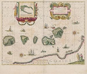
Original hand-coloured engraving. Plate Size: 48.9 cm x 37.1 Sheet Size: 53.5 cm x 45.3 cm. Original map. Good+ condition only. Some browning evident. Very minor tear barely noticeable to lower edge at center fold. Minor open tear to top left corner of sheet. Still a collectible version of this map. Centre fold as issued. Map orientated with north pointing to the right. Latin text on reverse. [Parry, Cartography of the East Indian Islands, plate 4.20]. Border with longitudinal and latitudinal information. Beautifully detailed map of the Maluku Islands or the Moluccas in eastern Indonesia. The islands were known as the Spice Islands contain five islands of Volcanic origin (Ternate, Tidore, Moti, Makian and Bacan) and were highly prized for being the only source of nutmeg, cloves and mace. Islands identified on map are Machian, Timor/Motir, Pottebackers Eylandy, Tidoro, Miterra, Ternate and Haerij. Top section of map has inset box (8.8 cm x 9 cm) showing Bachan Island in greater detail. Inset shows fortification that the Dutch East India Company seized from the Spanish in 1609 and renamed Fort Barneveld. Inset box with ornamental cartouche decorated with weapons and navigation instrument on either side. Decorative title cartouche in top section of map also. Gilolo Island (now known as Halmahera) shown in the lower corner of map. Two figures are shown in bottom left corner: one carrying shield and sword while the unarmed other is depicted with plate of offerings. Naval ships and junks depicted throughout map. Exchange of naval artillery fire between European warship and junk shown near centre of map. Whale-like creature shown in top right of map. Map also shows fortifications on Machian and Ternate. (Source: Digitial collection and information, 'Strait Through: Magellan to Cook & the Pacific,' available online from Princeton University website) Willem Janszoon Blaeu (1571-1638) was a Dutch cartographer, atlas maker and publisher. Along with his son Johannes Blaeu, Willem is considered one of the notable figures of the Netherlandish/Dutch school of cartography in its golden age (the 16th and 17th centuries). Blaeu set up his mapmaking and publishing business in Amsterdam, where he sold instruments and globes, published maps, and edited the works of intellectuals like Descartes and Hugo Grotius. In 1633 he was appointed map-maker of the Dutch East India Company. In 1635, he released his atlas, Theatrum Orbis Terrarum, sive, Atlas novus. Willem died in 1638. He had two sons, Cornelis (1610-1648) and Johannes (1596-1673). Joan trained as a lawyer, but joined his father s business rather than practice. After his father s death, the brothers took over their father s shop and Joan took on his work as hydrographer to the Dutch East India Company. Later in life, Joan would modify and greatly expand his father s Atlas novus, eventually releasing his masterpiece, the Atlas maior, between 1662 and 1672. (Wikipedia).
-

Sveviae nova tabula
Editore: Artist: Blaeu Willem Janszoon ( - 1638 ) Amsterdam ; issued in: Amsterdam ; ca: 1630; - Joan Guilliemus Blaeu was the eldest son of Willem Janszoon Blaeu (1571-1638) and was probably born in Alkmaar in the province of Noord-Holland in the final years of the 16th century He was brought up in Amsterdam and studied law at the University of Leiden before going into partnership with his father in the 1630s Although his father Willem had cartographic interests having studied under the Danish astronomer Tycho Brahe and having manufactured globes and instruments his primary business was as a printer It was under the control of Joan that the Blaeu printing press achieved lasting fame by moving towards the printing of maps and expanding to become the, 1571
Da: Antique Sommer& Sapunaru KG, München, Germania
Membro dell'associazione: ILAB VDA
Valutazione venditore:
Technic: Copper print; colorit: original colored; condition: Very good, size (in cm): 37 x 48; - Map shows total Swabia.
-
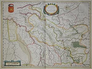
Kein Einband. Condizione: Gut bis sehr gut. Es handelt sich hierbei um eine originale, altkolorierte Kupferstich-Landkarte des Herzogtums Kleve von Willem Janszoon Blaeu, aus dem Jahr 1640. *** Titel: Clivia Ducatus Et Ravestein Dominium *** Gebiet bzw. Ort: Herzogtum Kleve *** Kartograph: Willem Janszoon Blaeu (1571 - 1638) *** Jahr: 1640 *** Größe des Plattenbereichs: 38 x 51 cm *** Technik: Kupferstich *** Zustand (Perfekt/ Sehr gut/ Gut/ Ordentlich/ Mäßig/ Schlecht): In sehr gutem Erhaltungszustand. Ein winziger Randeinriß oben links. Insgesamt altersgemäß gleichmäßig leicht getönt. *** Bemerkungen: Seltene Karte in dekorativem Alkolorit - - - International buyers welcome. If you have any questions, please don't hesitate to ask. --- Auf Wunsch stellen wir Ihnen gerne ein kostenfreies Echtheitszertifikat aus --- If you wish, we will gladly provide a certificate of authenticity free of charge ---.
-
Galloflandria, in qua Castellaniae Lilana, duacena, et orchiesia, cum dependentibus ; necnon Tornacum, et Tornacesium
Data di pubblicazione: 1650
Mappa
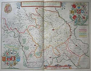
Kein Einband. Condizione: Gut. Es handelt sich hierbei um eine originale, kolorierte Kupferstich-Landkarte Französisch Flanderns und der Wallonie von Willem Janszoon Blaeu (1571 - 1638) ca. aus dem Jahr 1650. *** Titel: Galloflandria, in qua Castellaniae Lilana, duacena, et orchiesia, cum dependentibus ; necnon Tornacum, et Tornacesium *** Gebiet bzw. Ort: Französisch Flandern und die Wallonie *** Kartograph: Willem Janszoon Blaeu (1571 - 1638) *** Jahr: um 1650 *** Größe des Plattenbereichs: 39 x 50 cm *** Technik: Kupferstich *** Zustand (Perfekt/ Sehr gut/ Gut/ Ordentlich/ Mäßig/ Schlecht): In gutem Erhaltungszustand. Eine Knickspur aus dem Druckprozeß im linken Rand *** Bemerkungen: Diese aufwendig gestaltete, sehr dekorative Karte zeigt Französisch Flandern und die Wallonie u.a. mit den Städten Lille, Tournai, Courtray und Orchies - - - International buyers welcome. If you have any questions, please don't hesitate to ask. --- Auf Wunsch stellen wir Ihnen gerne ein kostenfreies Echtheitszertifikat aus --- If you wish, we will gladly provide a certificate of authenticity free of charge ---.
-
Tractus Rheni et Mosae totusq Vahalis a Rhenoberca Gorcomium usque cum terris adjacentibus ducatus Cliviae regno Noviomagensi et Bommelerwaert Parte insuper veteris Bataviae quae continet de Betouwe Tielerwaert et com Buyen, Cuylenborch et Leerdam
Data di pubblicazione: 1630
Mappa
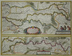
Kein Einband. Condizione: Gut bis sehr gut. Es handelt sich hierbei um eine originale, altkolorierte Kupferstich-Landkarte des Verlaufs des Niederrheins von Willem Janszoon Blaeu, ca. aus dem Jahr 1630. *** Titel: Tractus Rheni et Mosae totusq Vahalis a Rhenoberca Gorcomium usque cum terris adjacentibus ducatus Cliviae regno Noviomagensi et Bommelerwaert Parte insuper veteris Bataviae quae continet de Betouwe Tielerwaert et com Buyen, Cuylenborch et Leerdam. *** Gebiet bzw. Ort: Verlauf des Niederrheins von Wesel bis kurz vor der Mündung bei Rotterdam *** Kartograph: Willem Janszoon Blaeu (1571 - 1638) *** Jahr: 1630 *** Größe des Plattenbereichs: 39 x 51 cm *** Technik: Kupferstich *** Zustand (Perfekt/ Sehr gut/ Gut/ Ordentlich/ Mäßig/ Schlecht): In sehr gutem Erhaltungszustand. Altersgemäß insgesamt leicht gebräunt. *** Bemerkungen: Seltene Karte in dekorativem Altkolorit - Zwei Karten auf einem Blatt: Die untere (14 x 49 cm) zeigt den Rhein von Wesel bis Nijmengen, die obere (24 x 49 cm) von Kleve bis Culemborg. - - - International buyers welcome. If you have any questions, please don't hesitate to ask. --- Auf Wunsch stellen wir Ihnen gerne ein kostenfreies Echtheitszertifikat aus --- If you wish, we will gladly provide a certificate of authenticity free of charge ---.
-
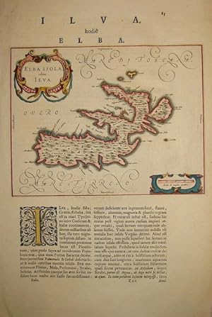
Elba Isola olim Ilva
Editore: Amsterdam, 1640
Da: Libreria Ex Libris ALAI-ILAB/LILA member, Roma, Italia
Membro dell'associazione: ALAI ILAB
Valutazione venditore:

Mappa
Carta geografica originale (cm. 26x20 piů ampi margini) entro pagina di testo tratta da un'edizione in lingua latina dell''Atlas maior'. Bella coloritura antica all'acquarello. Ottimo esemplare.
-
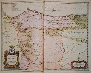
Kein Einband. Condizione: Gut. Es handelt sich hierbei um eine originale, altkolorierte Kupferstich-Landkarte des Königreichs Leon und des Fürstentums Asturien von Willem Janszoon Blaeu (1571 - 1638) aus dem Jahr 1640. *** Titel: Legionis Regnum et Asturiarum Principatus *** Gebiet bzw. Ort: Fürstentum Asturien und Königreich Leon in Nordspanien *** Kartograph: Willem Janszoon Blaeu (1571 - 1638) - Joan Blaeu (1596 - 1673) *** Jahr: 1640 *** Größe des Plattenbereichs: 38 x 48 cm *** Technik: Kupferstich *** Zustand (Perfekt/ Sehr gut/ Gut/ Ordentlich/ Mäßig/ Schlecht): In gutem Erhaltungszustand. Altersgemäß leicht gebräunt. *** Bemerkungen: Seltene Karte in dekorativem Altkolorit. Eingezeichnet sind unter anderem Oviedo, Asturia, Leon und Palencia. Zwei dekorative Kartuschen und eine Kompassrose ergänzen den Kartenbereich. - - - International buyers welcome. If you have any questions, please don't hesitate to ask. - - - Spain Asturias ----- Auf Wunsch stellen wir Ihnen gerne ein kostenfreies Echtheitszertifikat aus ------ If you wish, we will gladly provide a certificate of authenticity free of charge ---.
-
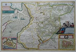
Kein Einband. Condizione: Sehr gut. Es handelt sich hierbei um eine originale, kolorierte Kupferstich-Landkarte des Gebiets von Dithmarschen von Willem Janszoon Blaeu (1571 - 1638) nach J. Mejer aus dem Jahr 1672. *** Titel: Dithmarsiae pars australis *** Gebiet bzw. Ort: Dithmarschen in Norddeutschland *** Kartograph: Willem Janszoon Blaeu (1571 - 1638) nach J. Mejer *** Jahr: 1672 *** Größe des Plattenbereichs: 40 x 60 cm *** Technik: Kupferstich *** Zustand (Perfekt/ Sehr gut/ Gut/ Ordentlich/ Mäßig/ Schlecht): In sehr gutem Erhaltungszustand *** Bemerkungen: - - - - International buyers welcome. If you have any questions, please don't hesitate to ask. --- Auf Wunsch stellen wir Ihnen gerne ein kostenfreies Echtheitszertifikat aus --- If you wish, we will gladly provide a certificate of authenticity free of charge ---.
-
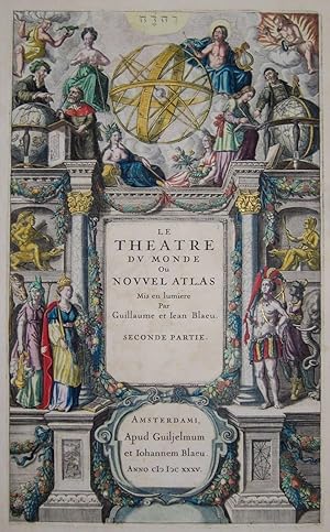
Kein Einband. Condizione: Gut. Es handelt sich hierbei um eine originale, altkolorierte Kupferstich-Titelseite aus Blaeus Nouvel Atlas , aus dem Jahr 1647. *** Titel: Le theatre du Monde ou Nouvel Atlas *** Gebiet bzw. Ort: Titelseite Kartograph: Willem Janszoon Blaeu (1571 - 1638) - Joan Blaeu (1596 - 1673) *** Jahr: 1647 *** Größe des Plattenbereichs: 40 cm x 25 cm *** Technik: Kupferstich *** Zustand (Perfekt/ Sehr gut/ Gut/ Ordentlich/ Mäßig/ Schlecht): In gutem Erhaltungszustand. Altersgemäß leicht gebräunt. *** Bemerkungen: Seltenes, sehr dekorativ altkoloriertes Titelblatt. Dargestellt sind im unteren Bereich des Blattes vier figürliche Allegorien der Kontinente (Asien, Amerika, Europa, Afrika) sowie im oberen Bereich in der Mitte eine Armillarsphäre flankiert von Apollo mit seiner Lyre, sowie Juno mit der Milchstraße. In der Mitte befinden sich zwei Geographen mit Erdgloben sowie Allegorien der vier Elemente Luft, Feuer, Erde und Wasser. - - - International buyers welcome. If you have any questions, please don't hesitate to ask. --- Auf Wunsch stellen wir Ihnen gerne ein kostenfreies Echtheitszertifikat aus --- If you wish, we will gladly provide a certificate of authenticity free of charge ---.
-
Kein Einband. Condizione: Sehr gut. Es handelt sich hierbei um eine originale, kolorierte Kupferstich-Landkarte des Gebiets des Herzogtums Schleswig von Willem Janszoon Blaeu (1571 - 1638) nach J. Mejer aus dem Jahr 1662. *** Titel: Nordertheil des Herzogthumbes Schleswieg *** Gebiet bzw. Ort: Herzogtum Schleswig - Südliches Dänemark *** Kartograph: Willem Janszoon Blaeu (1571 - 1638) nach J. Mejer *** Jahr: 1662 *** Größe des Plattenbereichs: 42 x 61 cm *** Technik: Kupferstich *** Zustand (Perfekt/ Sehr gut/ Gut/ Ordentlich/ Mäßig/ Schlecht): In sehr gutem Erhaltungszustand *** Bemerkungen: - - - - International buyers welcome. If you have any questions, please don't hesitate to ask. --- Auf Wunsch stellen wir Ihnen gerne ein kostenfreies Echtheitszertifikat aus --- If you wish, we will gladly provide a certificate of authenticity free of charge ---.
-
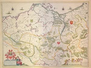
Brandenburgum Marchionatus cum Ducatibus Pomeraniae et Mecklenburgi
Editore: Artist: Blaeu Willem Janszoon ( - 1638 ) Amsterdam ; issued in: Amsterdam ; ca: 1635; - Joan Guilliemus Blaeu was the eldest son of Willem Janszoon Blaeu (1571-1638) and was probably born in Alkmaar in the province of Noord-Holland in the final years of the 16th century He was brought up in Amsterdam and studied law at the University of Leiden before going into partnership with his father in the 1630s Although his father Willem had cartographic interests having studied under the Danish astronomer Tycho Brahe and having manufactured globes and instruments his primary business was as a printer It was under the control of Joan that the Blaeu printing press achieved lasting fame by moving towards the printing of maps and expanding to become the, 1571
Da: Antique Sommer& Sapunaru KG, München, Germania
Membro dell'associazione: ILAB VDA
Valutazione venditore:
Technic: Copper print; colorit: colored; condition: Some restoration at lower centerfold, size (in cm): 40 x 53 cm; - Map shows Brandenburg with Berlin, Mecklenburg-Western Pomerania, three ship's stations, two wind roses and three coat-of-arms positions in the country. Furthermore, a title cartouche with the Brandenburg eagle in the coat of arms and a mileage indicator cartouche.