
Importo totale (1 articolo articoli):
Destinazione ordine:

a j defehrt 1773 copper engraving (1 risultati)
Vai alla pagina principale dei risultati di ricerca
Tipo di articolo
- Tutti gli articoli
- Libri
- Riviste e Giornali
- Fumetti
- Spartiti
- Arte, Stampe e Poster
- Fotografie
- Mappe (1)
-
Manoscritti e
Collezionismo cartaceo
Condizioni
- Tutte
- Nuovi
- Antichi o usati
Legatura
- Tutte
- Rilegato
- Brossura
Ulteriori caratteristiche
- Prima edizione
- Copia autografata
- Sovraccoperta
- Con foto
- No print on demand
Paese del venditore
Valutazione venditore
-
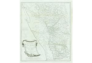
YEMEN: Tabula Itineraria sistens illam partem Terrae Yemen.
Da: Antiquariat Dasa Pahor GbR, München, Germania
Membro dell'associazione: ILAB VDA
Valutazione venditore:

Mappa
Deatailed early road map of Yemen, made by Carsten Niebuhr based on surveys from a scientific expedition sponsored by Frederick V of Denmark Detailed map printed on blue paper shows Yemen between Al Lu?ayyah, Sana'a and Mocha. Merked are all the important towns and roads. The author Carsten Niebuhr (1733 - 1815) was a German born mathamatician, living in Denmark from 1760. In 1761 he was sent to a scientific expedition sponsored by Frederick V of Denmark to Egypt, Arabia and Syria together with five other scientists. Niebuhr was the only one to survive the Danish Arabia Expedition. He returned to Copenhagen in 1767 and published the new discoveries in 1773 in 'Beschreibung von Arabien'. The work was followed with two other volumes with descriptions and maps of Arabian Peninsula 1774 and 1778. Ulrich Jasper Seetzen (1767 1811), a German explorer of Arabia and Palestine, said about Niebuhr's detailed map of Yemen: Niebuhr's Map is a masterpiece, which is very important for a tra hardly understand, how it was possible for a single man in such a short time to produce such and useful work. Niebuhr's methods of survey were much less sophisticated as thought by other explorers. He described them in his work: In the province Yemen one travels usually on a donkey. An approximately good donkey is walking so quickly, that a person who is trying to follow it, has to make 1750 steps in one half of hour. I had to discover this right at the beginning in order to make notes for an improved map. After I had known the speed, with which we were travelling, I only needed to mark the time we needed from one town to another and then calculate from steps and miles to establish the distances between towns One can therefore not expect that my travel map of Yemen looks exactly as the European maps, based on exact astronomical and geometrical observations. But one will notice I have not saved any diligence to collect so many information, as there were to demand, and have organizedavels t I could establish all the locations of the main towns in the area A.-J. Defehrt (De Fehrt, 1723 1774) was a French engraver, who made engravings among others for Buffon's, Histoire Naturelle and contributed to Diderot's Encyclopedie. References: Heinrich Karl Wilhelm BERGHAUS. Asia: Sammlung von Denkschriften in Beziehung auf die Geo- und HYdrographie (Gotha 1832), p.