Importo totale (1 articolo articoli):
Destinazione ordine:

blaeu w j atlases maps townboo (155 risultati)
Vai alla pagina principale dei risultati di ricerca
Tipo di articolo
- Tutti i tipi di prodotto
- Libri (97)
- Riviste e Giornali
- Fumetti
- Spartiti
- Arte, Stampe e Poster (14)
- Fotografie
- Mappe (44)
- Manoscritti e Collezionismo cartaceo
Condizioni
- Tutte
- Nuovi
- Antichi o usati (155)
Legatura
- Tutte
- Rilegato (100)
- Brossura
Ulteriori caratteristiche
- Prima ed. (1)
- Copia autograf.
- Sovracoperta
- Con foto (155)
- Non Print on Demand (155)
Spedizione gratuita
- Spedizione gratuita negli USA
Paese del venditore
Valutazione venditore
-
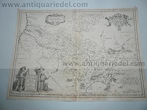
Hardcover. Condizione: very good. Picardia, map, Blaeu anno 1660 Coppermap, edited by G Blaeu, ca. anno 1660, no text on verso, size of the leaf: 40 x 55 cm., little waterstained, foxed.
-
Hardcover. Condizione: very good. Aardenburg-Ysendijck, Zeeland, Blaeu anno 1640, townbooks, dutch lanquage on verso, size of the leaf: 43x62 cm.
-
Hardcover. Condizione: very good. Bituricum ducatus, Duche de Berri, map, 1640, Blaeu J. Coppermap, edited by the Blaeu Family, anno 1640, german text on verso, size of the leaf: 46x54 cm., no cracs, little brownish.
-
Hardcover. Condizione: very good. Nivernois,ducatus,anno 1650, map, Blaeu Coppermap, edited by Blaeu Family, anno 1650, "NIVERNIVM DVCATVS. Gallice DVCHE DE NEVERS.", german text on verso, printed on thick paper, clean map, no cracs. size of the leaf: 46 x 54 cm.
-
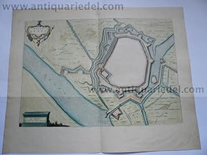
Hardcover. Condizione: very good. Coppermap, edited by Joan Blaeu, in his townbooks, anno 1649, size of the leaf: 49x62 cm., latin text on verso, restored crac on below margin (in the view).
-
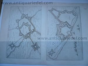
Hardcover. Condizione: very good. Büderich (BVRICK)-Wesel, anno 1700, Grundriss, Blaeu, Grundriss der Stadt, Blattmaß: 50x30 cm., Plan: 34x23 cm. Referenz: Fauser, Nr. 2126, lat. Rückentext. Büderich ist seit 1975 ein Ortsteil der Stadt Wesel, der zusammen mit dem Ortsteil Ginderich den Stadtteil Büderich mit seinen 6.227 Einwohnern (30. Juni 2006) bildet.
-
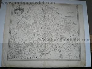
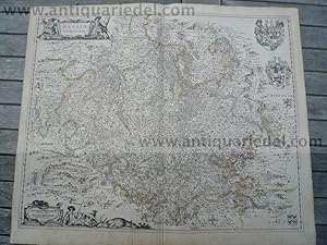
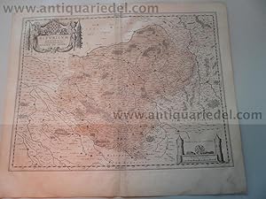
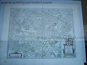
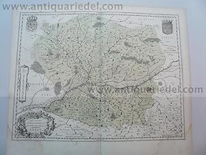
Hardcover. Condizione: very good. Wirtenberg Ducatus, anno 1640, Blaeu, Karte Wirtenberg Ducatus. Blattmaß: 46x58 cm., Württemberg mit angrenzenden Gebieten zwischen Heidelberg, Schwäbisch Hall, Lauingen / Donau, Memmingen, Villingen / Schwarzwald, Freiburg und dem Rhein von Straßburg bis Mannheim, mit Stuttgart im Zentrum der Karte. Etwas fingerfleckig, kleinere Randläsuren, an den Rändern kleinere Reparaturen.
-
Stift Hirschfeld, anno 1650, Blaeu, altkoloriert, dt. Rückentext
Editore: Blaeu W.+J.,Atlases,Maps,Townboo
Hardcover. Condizione: very good. Stift Hirschfeld, anno 1650, Blaeu, altkoloriert, franz. Rückentext Kupferkarte, verlegt bei Blaeu, Amsterdam, anno 1650, Blattmaß: 49x60 cm., Mittelfalz etwas geknittert; ansonsten guter Erhaltungszustand, breitrandig.
-
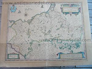
Hardcover. Condizione: very good. Please read german textKupferkarte, verlegt bei G. Blaeu, anno 1650, dt. Rückentext: "Das Hertzogthumb Meckelnburg" , alt koloriert, etwas gebräunt, untere Mittelfalz alt hinterlegt, min. Randläsuren. Blattmaß: 46x56 cm.
-
Hardcover. Condizione: very good. Anjou, anno 1640, Blaeu map Coppermap, edited by the Blaeu family, anno 1640, german text on verso, little waterstained, size of the leaf: 46x54 cm.
-
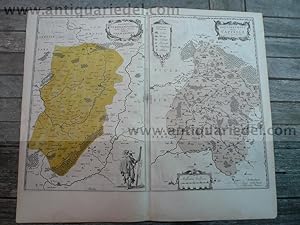
Hardcover. Condizione: very good. Vermandois/Capelle, 2 maps, Blaeu anno 1640 Title: Descriptio Veromanduorum . . . Gallice Vermandois [and] Gouvernement de la Cappelle . . . Map Maker: Willem Janszoon Blaeu Place / Date: Amsterdam / 1640 A nice pair of decorative regional maps on a single sheet. The Vermandois map is centered on the Oyse and Somme Rivers, and shows Chatelet, Beaurevoir, S. Quintin , Preone, Lafere, Channi and Noyon, amoung other larger towns in the region. The Cappelle map is centered on the Oyse and includes Vervins, La Cappelle, Aubanton and Marle, amoung others. Both with title carouches and additional embellishments. German lanquage on verso, size of the leaf: 46x54 cm., little waterstained, no cracs.
-
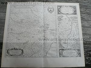
Hardcover. Condizione: very good. Lemovicum-Limosin, Limaniae, anno 1650, Blaeu Willem Janszoon Blaeu: Lemovicum - Lymosin (and) Topographia Limaniae Acutore Gabriele Simeoneo. Size of the leaf: 46x54 cm., german text on verso, good print, no cracs. Decorative map of the Limosin and Limoge region, with decorative cartouches. Large inset of the Elaver River region.
-
Bavaria Ducatus, anno 1665, Blaeu J., Atlas Major, altkoloriert,
Editore: Blaeu W.+J.,Atlases,Maps,Townboo
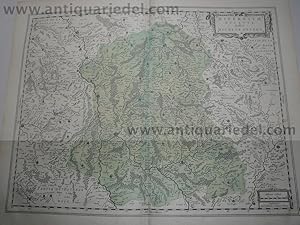
Hardcover. Condizione: very good. Bavaria Ducatus, anno 1665, Blaeu J., Atlas Major, altkoloriert, span. Rückentext, Blattmaß: 64x52 cm. Das Blatt ist stark wasser-und sporenfleckig. Die detaillreiche Karte zeigt das Herzogtum Bayern, das Gebiet zwischen den Flüssen Lech, Donau, Inn-Salzach und Traun mit den Alpen im Süden. Die Karte wird begrenzt durch die Ortschaften Füssen , Landsberg und Augsburg im Westen, Donauwörth, Regensburg und Passau im Norden, Wels und Salzburg im Osten sowie Zell am See und Innsbruck im Süden. Rechts unten große, dekorative Titelkartusche "Bavaria Ducatus / Per Ger. Mercatorem" , auf der Kartusche sitzende weibliche Figur mit bayrischem Wappen. Darunter Meilenanzeiger (Milliaria Bavarica). Links daneben Verlegerhinweis "Apud Guiljelmum Blaeu.".
-
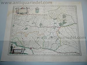
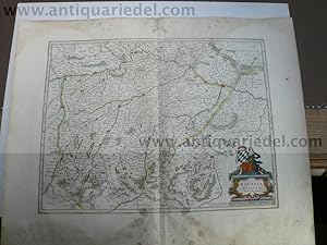
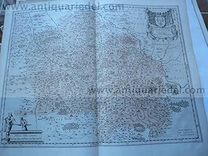
Hardcover. Condizione: very good. Lionnois,map,Blaeu,anno 1650, old coloured Coppermap, edited by the Blaeu family, anno 1650: "LIONNOIS, FOREST, BEAUIOLOIS ET MASCONNOIS", Original coloured in outline. Oriented to the west on the top, wide margins, upper margin little waterstained, german text on verso, with the rivers Loire and Rhone. Size of the leaf: 45 x 54 cm., of the map: 38 x 50 cm.
-

Hardcover. Condizione: very good. Beauvais, map, Blaeu, anno 1650, german edition Coppermap, edited by the Blaeu family, approx. anno 1650, german text on verso, Beauvais in the centre of the map, little waterstained on margins, printed on thick paper. Size of the leaf: 46 x 54 cm.
-
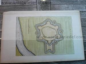
Hardcover. Condizione: very good. Duisburg-Ruhrort (ROEROORDT), anno 1700, Blaeu, Grundriss. Planmaß: 37x49 cm. Referenz: Fauser, Nr. 3318. Wir haben auch einen unkolorierten Plan im Angebot. Bei Interesse bitten wir um Nachfrage.
-
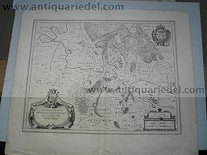
Hardcover. Condizione: very good. Sedan,Raucourt, map anno 1640, Blaeu J. Raucourt , Sedan - Lothringen, Champagne-Ardenne / Frankreich , Lorraine , Champagne-Ardenne / France Les Souverainetez de Sedan et de Ravcourt et la Prevoste de Doncheri Kupferstich, Blatt: ca 59 x 49,5 cm Gut erhalten, leicht gebräunt und fleckig, kleine Risse im Rand, Falte leicht knittrig. copper engraving , paper:ca 59 x 49,5 cm Good condition, light browning and staining, small tears in margins, soft folds in the middle.
-

Hardcover. Condizione: very good. Copperengraving, "Stenovicum Obsessa", dutch text on verso, edited anno 1649 in Tooneel der Steden van de Vereenighde Niederlanden, size of the leaf: 46x66 cm., some small cracs on margins.
-
Hardcover. Condizione: very good. Borbonium ducatus. J.Blaeu, anno 1645, dt. Ausgabe, Blatt: 47x54 cm., dt. Rückentext, gering fleckig.
-

Hardcover. Condizione: very good. Wirtenberg Ducatus, anno 1662, Blaeu-Atlas Major, span. Rückentext. Wirtenberg Ducatus. Altkolorierte Karte, Blattmaß: 52x64 cm., Württemberg mit angrenzenden Gebieten zwischen Heidelberg, Schwäbisch Hall, Lauingen / Donau, Memmingen, Villingen / Schwarzwald, Freiburg und dem Rhein von Straßburg bis Mannheim, mit Stuttgart im Zentrum der Karte. Dekoratives Blatt, oben und unten jeweils großer Wasserfleck, geringfügig in die Karte reichend.
-
Kein Einband. Condizione: Befriedigend. Kupferkarte, verlegt von J. Blaeu, anno 1650, lat. Rückentext, Blatt: 50x60 cm., grenzkoloriert. Am unteren Rand kleiner restaurierter Einriss, ca. 15 cm.
-
Hardcover. Condizione: very good. Principatus anhaltinus, Blaeu map, anno 1662 Principatus Anhaltinus, Kupferkarte aus Blaeu J. Atlas Major, span. Ausgabe, Teil III, verlegt anno 1662. Kartenmaß: 38 x 52 cm., breitrandig, an den Blatträndern, besonders oben und unten sporenfleckig; die Karte ist wenig betroffen. Alt grenzkoloriert. Zeigt die Elbe von Wittenberg bis nach Magdeburg, im Süden Mansfeld.
-
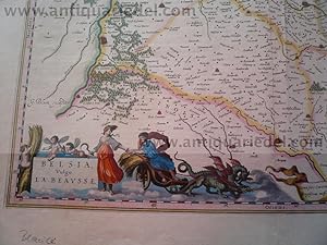
Hardcover. Condizione: very good. Belsia, vulgo la Beausse, map, anno 1650, Blaeu Coppermap, edited by the Blaeu Family, approx. anno 1650, french text on verso, size of the leaf: 50x58 cm. some small cracs on margins, small restorations on upper and below centerfold (outside of the map).
-

Wangen-Bettensweiler-Hergensweiler, anno 1662, Blaeu-Atlas Major
Editore: Blaeu W.+J.,Atlases,Maps,Townboo
Hardcover. Condizione: very good. "Territorii Lindaviensis pars Septentrionalis". altkol. Kupferstich nach Johann Andreas Rauben bei Blaeu, 1662, 29 x 24 cm. Koeman BI 60 A, 94. - Aus dem "Atlas Major". - Die Karte zeigt das Gebiet zwischen Wangen, Bettensweiler und Hergensweiler.
-

Hardcover. Condizione: very good. Büderich (BVRICK)/Orsoy-Rheinberg, anno 1700, Blaeu. Büderich (BVRICK)+Orsoy-Theinberg, anno 1700, Grundriss, Blaeu, Blattmaß: 50x60 cm., Referenz: Fauser, Nr. 2126, 10391,holl. Rückentext.
-

Hardcover. Condizione: very good. Ile de France, anno 1660, Blaeu, old colours We offer an original copperengraving from G. Blaeu, edited approx. anno 1660: " LE GOUVERNEMENT DE L ISLE DE FRANCE", size of the leaf: 53 x 62cm., some cracs on margins, little brownish. The surface of the map is ok.
-
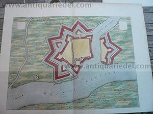
Hardcover. Condizione: very good. Rhenoberca Obsessa et Capta Armis Ordinum Belgicae Foederatae - Blaeu J. ,1649. Copper engraving Size: 45.5 x 55.5cm Verso text: blank Condition: coloured.
-
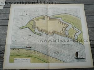
Kleve-Schenkenschanz, anno 1660, Blaeu
Editore: Blaeu W.+J.,Atlases,Maps,Townboo, 1660
Arte / Stampa / Poster
Kein Einband. Condizione: Gut. Kupferstich, verlegt ca. 1660, lat. Rückentext, Blattmaß:50x60 cm.Sehr guter Erhaltungszustand.
-
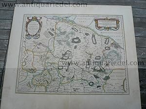
Hardcover. Condizione: very good. Kupferkarte, verlegt von Blaeu W + J, in Nouvel Atlas, Teil I, anno 1642, Blattmaß: 51x60 cm. An der unteren Mittelfalz zwei minimale, hinterlegte Einrisse auf 2 cm., altkoloriert, gering gebräunt. Zeigt das Gebiet zwischen Hamburg, Magdeburg und Bremen.
-
Hardcover. Condizione: very good. [WALDECK.] Blaeu: Waldeck comitatus (Grafschaft Waldeck/Nordhessen). Verlegt in Atlas Novus, Bd. I, 1642, franz. Ausgabe. Kupferstichkarte, 51 x 60 cm. Sauber, breitrandig, Mittelfalz ohne Läsuren. Dekorative Karte der Grafschaft Waldeck mit dem Gebiet bis Meschede, Brilon, Warburg, Fritzlar, Frankenberg, Schmalenberg; in Bildmitte: Korbach. Mit zwei ausgemalten Kartuschen.