Importo totale (1 articolo articoli):
Destinazione ordine:

brion tour (250 risultati)
Vai alla pagina principale dei risultati di ricerca
Tipo di articolo
- Tutti gli articoli
- Libri (120)
- Riviste e Giornali
- Fumetti
- Spartiti
- Arte, Stampe e Poster (18)
- Fotografie
- Mappe (112)
-
Manoscritti e
Collezionismo cartaceo
Condizioni
Legatura
Ulteriori caratteristiche
Spedizione gratuita
Paese del venditore
Valutazione venditore
-
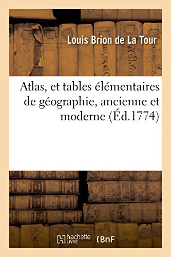
Atlas, Et Tables Élémentaires de Géographie, Ancienne Et Moderne (Histoire) (French Edition)
Editore: Hachette Livre Bnf, 2016
ISBN 10: 2019554631ISBN 13: 9782019554637
Libro
Condizione: New.
Ulteriori offerte da altri venditori AbeBooks
Nuovo - A partire da EUR 16,96
-

Baron de Las Casas (Histoire) (French Edition)
Editore: Hachette Livre Bnf, 2014
ISBN 10: 2013482809ISBN 13: 9782013482806
Libro
Condizione: New.
Ulteriori offerte da altri venditori AbeBooks
Nuovo - A partire da EUR 22,07
-
![Immagine del venditore per Atlas itineraire portatif de l'Europe (1776) [LeatherBound] venduto da True World of Books](https://pictures.abebooks.com/inventory/md/md31618321112.jpg)
Atlas itineraire portatif de l'Europe (1776) [LeatherBound]
Data di pubblicazione: 2023
Libro Print on Demand
LeatherBound. Condizione: New. LeatherBound edition. Condition: New. Reprinted from 1776 edition. Leather Binding on Spine and Corners with Golden leaf printing on spine. Bound in genuine leather with Satin ribbon page markers and Spine with raised gilt bands. A perfect gift for your loved ones. NO changes have been made to the original text. This is NOT a retyped or an ocr'd reprint. Illustrations, Index, if any, are included in black and white. Each page is checked manually before printing. As this print on demand book is reprinted from a very old book, there could be some missing or flawed pages, but we always try to make the book as complete as possible. Fold-outs, if any, are not part of the book. If the original book was published in multiple volumes then this reprint is of only one volume, not the whole set. Sewing binding for longer life, where the book block is actually sewn (smythe sewn/section sewn) with thread before binding which results in a more durable type of binding. Pages: 14.
-
![Immagine del venditore per Du partage de la peau de l'ours, ou, Lettres a l'auteur du Reve politique sur le partage de l'empire Ottoman et a l'auteur des Considerations sur la guerre actuelle des Turcs / (1788) [LeatherBound] venduto da True World of Books](https://pictures.abebooks.com/inventory/md/md31618713768.jpg)
Du partage de la peau de l'ours, ou, Lettres a l'auteur du Reve politique sur le partage de l'empire Ottoman et a l'auteur des Considerations sur la guerre actuelle des Turcs / (1788) [LeatherBound]
Data di pubblicazione: 2023
Libro Print on Demand
LeatherBound. Condizione: New. LeatherBound edition. Condition: New. Reprinted from 1788 edition. Leather Binding on Spine and Corners with Golden leaf printing on spine. Bound in genuine leather with Satin ribbon page markers and Spine with raised gilt bands. A perfect gift for your loved ones. NO changes have been made to the original text. This is NOT a retyped or an ocr'd reprint. Illustrations, Index, if any, are included in black and white. Each page is checked manually before printing. As this print on demand book is reprinted from a very old book, there could be some missing or flawed pages, but we always try to make the book as complete as possible. Fold-outs, if any, are not part of the book. If the original book was published in multiple volumes then this reprint is of only one volume, not the whole set. Sewing binding for longer life, where the book block is actually sewn (smythe sewn/section sewn) with thread before binding which results in a more durable type of binding. Pages: 52 Brion de la Tour, Louis, -1823.,Brion de la Tour, Louis, -1823,Volney, C.-F. (Constantin-Franc?ois), 1757-1820. Conside?rations sur la guerre actuelle des Turcs.
-
![Immagine del venditore per Tableau de la population de la France: avec les citations des auteurs, au nombre de soixante-douze qui ont ecrit sur cette partie de la statistique, relative a la France seule. Suivi d'un Tableau de l'etendue quarree des generalites du royaume: avec une carte divisee par gouvernements generaux et par generalites 1789 [LeatherBound] venduto da True World of Books](https://pictures.abebooks.com/inventory/md/md31617667228.jpg)
Tableau de la population de la France: avec les citations des auteurs, au nombre de soixante-douze qui ont ecrit sur cette partie de la statistique, relative a la France seule. Suivi d'un Tableau de l'etendue quarree des generalites du royaume: avec une carte divisee par gouvernements generaux et par generalites 1789 [LeatherBound]
Data di pubblicazione: 2023
Libro Print on Demand
LeatherBound. Condizione: New. LeatherBound edition. Condition: New. Reprinted from edition. Leather Binding on Spine and Corners with Golden leaf printing on spine. Bound in genuine leather with Satin ribbon page markers and Spine with raised gilt bands. A perfect gift for your loved ones. NO changes have been made to the original text. This is NOT a retyped or an ocr'd reprint. Illustrations, Index, if any, are included in black and white. Each page is checked manually before printing. As this print on demand book is reprinted from a very old book, there could be some missing or flawed pages, but we always try to make the book as complete as possible. Fold-outs, if any, are not part of the book. If the original book was published in multiple volumes then this reprint is of only one volume, not the whole set. Sewing binding for longer life, where the book block is actually sewn (smythe sewn/section sewn) with thread before binding which results in a more durable type of binding. Pages: 83.
-
![Immagine del venditore per Recueil des Cotes Maritimes de France 1766 [LeatherBound] venduto da True World of Books](https://pictures.abebooks.com/inventory/md/md31617543692.jpg)
Recueil des Cotes Maritimes de France 1766 [LeatherBound]
Data di pubblicazione: 2023
Libro Print on Demand
LeatherBound. Condizione: New. LeatherBound edition. Condition: New. Reprinted from edition. Leather Binding on Spine and Corners with Golden leaf printing on spine. Bound in genuine leather with Satin ribbon page markers and Spine with raised gilt bands. A perfect gift for your loved ones. NO changes have been made to the original text. This is NOT a retyped or an ocr'd reprint. Illustrations, Index, if any, are included in black and white. Each page is checked manually before printing. As this print on demand book is reprinted from a very old book, there could be some missing or flawed pages, but we always try to make the book as complete as possible. Fold-outs, if any, are not part of the book. If the original book was published in multiple volumes then this reprint is of only one volume, not the whole set. Sewing binding for longer life, where the book block is actually sewn (smythe sewn/section sewn) with thread before binding which results in a more durable type of binding. Pages: 237.
-
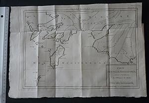
CARTE DES ISLES RHODIENNES SERVANT Ŕ L'INTELLIGENCE DE L'HISTOIRE DE MALTE (2e moitié du XVIIIe sičcle).
Da: Mesnard - Comptoir du Livre Ancien, Ruelle-sur-Touvre, Francia
Valutazione venditore:

1 carte sur papier d'époque 23,5 x 34,3 cm (partie gravée) - Trčs bel état. NOTICE FOR FOREIGN CUSTOMERS : The ECONOMIC SHIPPING RATE is reserved by FRENCH POST for books whose weight is less than 2KG ! We have limited too this offer for books whose value is less than 30 euros. Shipping will increase if you choose this rate for a value or heavy book. If you select a Paypal payment in this particular case we cannot change the shipping rate on Abebooks but this one will increase in the Paypal invoice. So be careful please to select the appropriate shipping rate taking into consideration the book value or the weight or both.
-
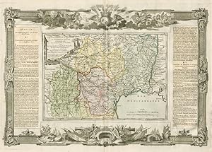
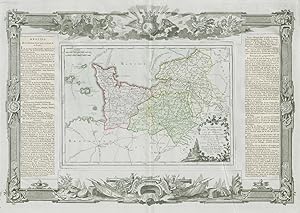
La France, divisée en ses quarante Gouvernemens Généraux et Militaires, dans leur étenduë actuelle et par Provinces Ecclésiastiques. Par Mr. Brion Ingénr. Géographe du Roi: mise au jour, par le Sr. Desnos Ingr. Géog' pour les Globes et Sphčres, ruë St. Jacques, a l'énseigne du Globe. 1766
Data di pubblicazione: 1771
Mappa
Condizione: Good. "La France par Provinces Ecclésiastiques". DESNOS/DE LA TOUR 1771 old map. Antique eighteenth century copperplate atlas map with original hand colour, and ornate border. The flanking columns of descriptive text were stuck onto the sheet at the time of publication; Louis Brion de la Tour / Louis Desnos (1771). 56.5 x 44.0cm, 22.25 x 17.25 inches; this is a folding map. Condition: Good. There is nothing printed on the reverse side, which is plain. France, divided into Ecclestiastical provinces".
-
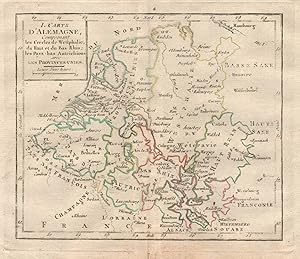
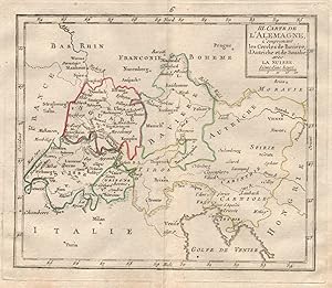
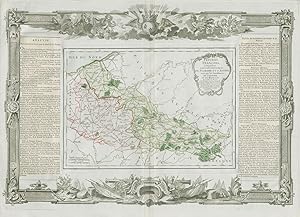
I. Carte d'Alemagne, comprenant les Cercles de Westphalie, du Haut et du Bas Rhin; les Pays-bas Autrichiens avec les provinces Unies
Data di pubblicazione: 1777
Mappa
Condizione: Good. "I. Carte d'Alemagne" by BRION DE LA TOUR. Benelux Westphalia Alsace 1777 map. Antique copperplate map with original outline colour; Gravées par André sur les dessins de Louis Brion de la Tour (1777). 18.5 x 16.5cm, 7.25 x 6.25 inches; this is a folding map. Condition: Good. There is nothing printed on the reverse side, which is plain.
-
III. Carte d'Alemagne, comprenant les Cercles de Baviére, d'Autriche et de Souabe avec La Suisee
Data di pubblicazione: 1777
Mappa
Condizione: Good. "III. Carte d'Alemagne". BRION DE LA TOUR. Switzerland Austria Bavaria 1777 map. Antique copperplate map with original outline colour; Gravées par André sur les dessins de Louis Brion de la Tour (1777). 18.5 x 16.5cm, 7.25 x 6.25 inches; this is a folding map. Condition: Good. There is nothing printed on the reverse side, which is plain.
-
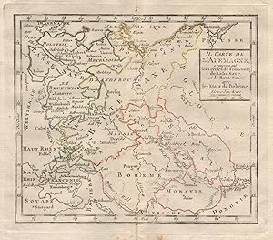
II. Carte d'Alemagne, comprenant les Cercles de Franconie, de Basse Saxe et de Haute Saxe avec les Etats de Boheme
Data di pubblicazione: 1777
Mappa
Condizione: Good. "II. Carte d'Alemagne" by BRION DE LA TOUR. Germany Poland Czechia 1777 map. Antique copperplate map with original outline colour; Gravées par André sur les dessins de Louis Brion de la Tour (1777). 18.5 x 16.5cm, 7.25 x 6.25 inches; this is a folding map. Condition: Good. There is nothing printed on the reverse side, which is plain.
-
Condizione: Good. "Gouvernemens de Normandie et du Havre". Normandy. DESNOS/DE LA TOUR 1771 map. Antique eighteenth century copperplate atlas map with original hand colour, and ornate border. The flanking columns of descriptive text were stuck onto the sheet at the time of publication; Louis Brion de la Tour / Louis Desnos (1771). 56.5 x 44.0cm, 22.25 x 17.25 inches; this is a folding map. Condition: Good. There is nothing printed on the reverse side, which is plain. Normandy including Le Havre, Rouen, Caen and Alençon.
-
Condizione: Good. "Les Duchés de Lorraine, Bar Metz, Toul et Verdun". DESNOS/DE LA TOUR 1771 map. Antique eighteenth century copperplate atlas map with original hand colour, and ornate border. The flanking columns of descriptive text were stuck onto the sheet at the time of publication; Louis Brion de la Tour / Louis Desnos (1771). 56.5 x 44.0cm, 22.25 x 17.25 inches; this is a folding map. Condition: Good. Spot. There is nothing printed on the reverse side, which is plain. The Duchies of Lorraine, and of Bar, and the Bishoprics of Metz, Toul, and Verdun. Eastern France".
-
Condizione: Good. "Pays-Bas François, comprenant Flandre et d'Artois". DESNOS/DE LA TOUR 1771 map. Antique eighteenth century copperplate atlas map with original hand colour, and ornate border. The flanking columns of descriptive text were stuck onto the sheet at the time of publication; Louis Brion de la Tour / Louis Desnos (1771). 56.5 x 44.0cm, 22.25 x 17.25 inches; this is a folding map. Condition: Good. There is nothing printed on the reverse side, which is plain. The French low countries, comprising French Flanders (Nord) and Artois (Pas-de-Calais)".
-
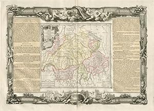
La Suisse, diviseé en ses Cantons, ses Alliés, et Sujčts, et. distinguée en Pays Catholiques, Protestans et Mixtes. Par le Sr. Brion, Ingénieur Géographe du Roy ŕ Paris, Chez le Sr. Desnos, Ingén. Géographe pour les Globes, et Sphéres, ruë St. Jacques au Globe. 1764
Data di pubblicazione: 1771
Mappa
Condizione: Good. "La Suisse". Switzerland. DESNOS/DE LA TOUR 1771 old antique map plan chart. Antique eighteenth century copperplate atlas map with original hand colour, and ornate border. The flanking columns of descriptive text were stuck onto the sheet at the time of publication; Louis Brion de la Tour / Louis Desnos (1771). 56.5 x 44.0cm, 22.25 x 17.25 inches; this is a folding map. Condition: Good. There is nothing printed on the reverse side, which is plain.
-
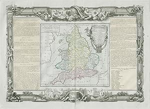
Condizione: Good. "L'Angleterre divisée en 5 grandes parties". England. DESNOS/DE LA TOUR 1771 map. Antique eighteenth century copperplate atlas map with original hand colour, and ornate border. The flanking columns of descriptive text were stuck onto the sheet at the time of publication; Louis Brion de la Tour / Louis Desnos (1771). 56.5 x 44.0cm, 22.25 x 17.25 inches; this is a folding map. Condition: Good. There is nothing printed on the reverse side, which is plain. England, unusually divided into 5 major parts.
-
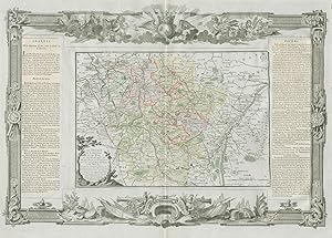
Cercles de Baviere, de Franconie et de Souabe: divisés en toutes leurs Principautés, et Provinces tant Séculičres qu'Ecclesiastiques. Par Mr. Brion Ingr.-Géographe du Roi. ŕ Paris Chez le Sr. Desnos Ing? Géog? pour les Globes et Sphčres, Ruë St. Jacques au Globe. 1766
Data di pubblicazione: 1771
Mappa
Condizione: Good. Cercles de Baviere, de Franconie et de Souabe Germany DESNOS/DE LA TOUR 1771 map. Antique eighteenth century copperplate atlas map with original hand colour, and ornate border. The flanking columns of descriptive text were stuck onto the sheet at the time of publication; Louis Brion de la Tour / Louis Desnos (1771). 56.5 x 44.0cm, 22.25 x 17.25 inches; this is a folding map. Condition: Good. There is nothing printed on the reverse side, which is plain. Circles of Bavaria, Franconia, and Swabia. Southern Germany.
-
Cercles de Westphalie, Haut et Bas Rhin, divisés en toutes leurs Principautés et Provinces, tant Séculičres qu'Ecclésiastiques. A Paris, Chéz le Sr. Desnos Ing? Géog? pour les Globes et Sphčres rüe Saint Jacques au Globe. 1766
Data di pubblicazione: 1771
Mappa
Condizione: Good. "Cercles de Westphalie, Haut et Bas Rhin". Germany. DESNOS/DE LA TOUR 1771 map. Antique eighteenth century copperplate atlas map with original hand colour, and ornate border. The flanking columns of descriptive text were stuck onto the sheet at the time of publication; Louis Brion de la Tour / Louis Desnos (1771). 56.5 x 44.0cm, 22.25 x 17.25 inches; this is a folding map. Condition: Good. There is nothing printed on the reverse side, which is plain. Westphalia, Upper and Lower Rhine. North West Germany. Hessen, Nordrhein-Westfalen, Bremen Niedersachsen & Rheinland-Pfalz.
-
Cercles de Haute et Basse Saxe, divisés, en toutes leurs Principautés et Provinces, tant Séculičres qu'Ecclésiastiques. A Paris, Chez le Sr. Desnos, Ingén. Géograph pour les Globes et Sphčres, Ruë St. Jacques au Globe. 1766
Data di pubblicazione: 1771
Mappa
Condizione: Good. "Cercles de Haute et Basse Saxe" Lower & Upper Saxony DESNOS/DE LA TOUR 1771 map. Antique eighteenth century copperplate atlas map with original hand colour, and ornate border. The flanking columns of descriptive text were stuck onto the sheet at the time of publication; Louis Brion de la Tour / Louis Desnos (1771). 56.5 x 44.0cm, 22.25 x 17.25 inches; this is a folding map. Condition: Good. There is nothing printed on the reverse side, which is plain. Circles of Upper and Lower Saxony. North East Germany: Brandenburg, Sachsen-Anhalt, Thuringen, mecklenburg-Vorpommern, Holstein & Bremen-Niederscachsen.
-
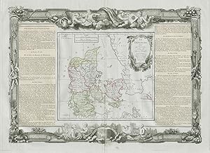
Le Danemark divisé par Provinces, et Diocčses sous une Métropole. Par le Sr. Brion. Ingénieur-Géographe du Roi. A Paris chez le Sr. Desnos. Ingenr pour les Globes et Sphéres, ruë St. Jacques au Globe. 1766
Data di pubblicazione: 1771
Mappa
Condizione: Good. "Le Danemark divisé par provinces ". Denmark. DESNOS/DE LA TOUR 1771 old map. Antique eighteenth century copperplate atlas map with original hand colour, and ornate border. The flanking columns of descriptive text were stuck onto the sheet at the time of publication; Louis Brion de la Tour / Louis Desnos (1771). 56.5 x 44.0cm, 22.25 x 17.25 inches; this is a folding map. Condition: Good. Blemish in margin. There is nothing printed on the reverse side, which is plain. Denmark divided by Provinces, and Dioceses".
-
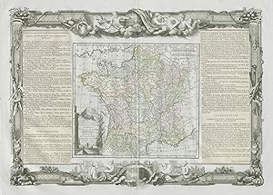
Voyage Dans Les Départemens De La France : Enrichi de Tableaux Géographiques et d'Estampes [23] [Département De La Haute-Marne]
Editore: Paris Brion, 1793
Prima edizione
Couverture souple. Condizione: Bon. Edition originale. In-8° broché, exemplaire dérelié, bien complet de la grande carte double page en couleurs, 31 pages.
-
Condizione: Good. "Gouvernemens de Languedoc de Roussillon " Occitanie. DESNOS/DE LA TOUR 1771 map. Antique eighteenth century copperplate atlas map with original hand colour, and ornate border. The flanking columns of descriptive text were stuck onto the sheet at the time of publication; Louis Brion de la Tour / Louis Desnos (1771). 56.5 x 44.0cm, 22.25 x 17.25 inches; this is a folding map. Condition: Good. There is nothing printed on the reverse side, which is plain. Languedoc, Roussillon, Foix, and part of Guienne and Gascogne. Toulouse, Montpellier, Montauban, Perpignan, and Auch. Occitanie".
-
Condizione: Good. Poitou, Berri, Bourbonnois & Nivernois. Pays / Loire. DESNOS/DE LA TOUR 1771 map. Antique eighteenth century copperplate atlas map with original hand colour, and ornate border. The flanking columns of descriptive text were stuck onto the sheet at the time of publication; Louis Brion de la Tour / Louis Desnos (1771). 56.5 x 44.0cm, 22.25 x 17.25 inches; this is a folding map. Condition: Good. There is nothing printed on the reverse side, which is plain. Poitou, Berry, Bourbonnais, and Nivernais.
-
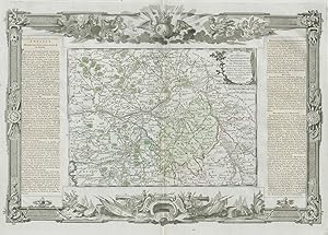
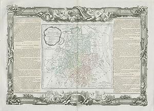
Gouvernemens et Généralités de Bourgogne et de Franche-Comté. Corrigés, et augmentés de toutes les Routes avec les Distances en Lieuës d'usage dans ces Pays par Mr. Brion, I.G. du Roy 1771
Data di pubblicazione: 1771
Mappa
Condizione: Good. "Gouvernemens de Bourgogne et de Franche-Comté". DESNOS/DE LA TOUR 1771 map. Antique eighteenth century copperplate atlas map with original hand colour, and ornate border. The flanking columns of descriptive text were stuck onto the sheet at the time of publication; Louis Brion de la Tour / Louis Desnos (1771). 56.5 x 44.0cm, 22.25 x 17.25 inches; this is a folding map. Condition: Good. There is nothing printed on the reverse side, which is plain. Burgundy and Franche-Comté".
-
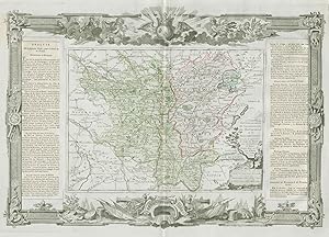
Gouvernemens d'Orléanois, de Touraine, du Maine, d'Anjou, et du Saumu: rois; Avec les Généralités d'Orléans et de Tours. Subdivisés en petits pays, avec toutes les routes, et les distances en lieues d'usage dans chaque Province. ŕ Paris chez le Sr. Desnos Ing. Géo, Rue St. Jacques au Globe. 1771
Data di pubblicazione: 1771
Mappa
Condizione: Good. Orléanois, Touraine, Maine, Anjou & Saumurois. Loire. DESNOS/DE LA TOUR 1771 map. Antique eighteenth century copperplate atlas map with original hand colour, and ornate border. The flanking columns of descriptive text were stuck onto the sheet at the time of publication; Louis Brion de la Tour / Louis Desnos (1771). 56.5 x 44.0cm, 22.25 x 17.25 inches; this is a folding map. Condition: Good. There is nothing printed on the reverse side, which is plain. Loire Valley. Orleans, Touraine, Maine, Anjou, and Saumurois.
-
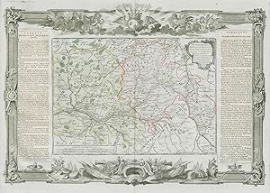
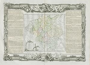
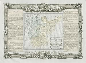
L'Alemagne divisée en tous ses cercles avec les Pays qui en dépendent assujettie aux observations astronomiques, combinées avec les itinéraires tant anciens, que modernes. Par le Sr. Brion, Ingénieur- Géographe du Roy. ŕ Paris, chez le Sr. Desnos, rue St. Jacques, au Globe. 1766
Data di pubblicazione: 1771
Mappa
Condizione: Good. "L'Alemagne divisée en tous ses cercles". Germany. DESNOS/DE LA TOUR 1771 map. Antique eighteenth century copperplate atlas map with original hand colour, and ornate border. The flanking columns of descriptive text were stuck onto the sheet at the time of publication; Louis Brion de la Tour / Louis Desnos (1771). 56.5 x 44.0cm, 22.25 x 17.25 inches; this is a folding map. Condition: Good. Spot. There is nothing printed on the reverse side, which is plain. Germany divided into all its circles.
-
Condizione: Good. "L'Isle de France et de Champagne". Île-de-France. DESNOS/DE LA TOUR 1771 map. Antique eighteenth century copperplate atlas map with original hand colour, and ornate border. The flanking columns of descriptive text were stuck onto the sheet at the time of publication; Louis Brion de la Tour / Louis Desnos (1771). 56.5 x 44.0cm, 22.25 x 17.25 inches; this is a folding map. Condition: Good. There is nothing printed on the reverse side, which is plain. The Île de France and Champagne, including Paris and Chalons.
-
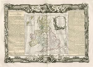
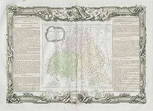
Les Isles Britanniques, assujetties aux observations astronomiques, combinées avec les itinéraires tant ancien, que moderne. Par le Sr. Brion, Ingénieur-Géographe du Roi. ŕ Paris, chez Desnos, Ingén? Géogr? pour les Globes et Sphčres, ruë St. Jacques, au Globe. 1766
Data di pubblicazione: 1771
Mappa
Condizione: Good. "Les Isles Britanniques". British Isles. DESNOS/DE LA TOUR 1771 old map. Antique eighteenth century copperplate atlas map with original hand colour, and ornate border. The flanking columns of descriptive text were stuck onto the sheet at the time of publication; Louis Brion de la Tour / Louis Desnos (1771). 56.5 x 44.0cm, 22.25 x 17.25 inches; this is a folding map. Condition: Good. There is nothing printed on the reverse side, which is plain. The British Isles.
-
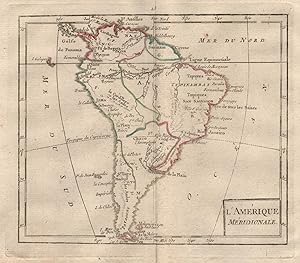
Condizione: Good. "L'Amérique Méridionale" by BRION DE LA TOUR. South America 1777 old map. Antique copperplate map with original outline colour; Gravées par André sur les dessins de Louis Brion de la Tour (1777). 18.5 x 16.5cm, 7.25 x 6.25 inches; this is a folding map. Condition: Good. There is nothing printed on the reverse side, which is plain.
-
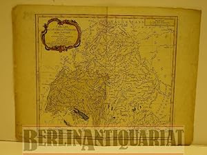
Cercles de Bavičre, de Franconie et de Souabe: divisés en toute leur Principautés et provinces. Altkolorierter Kupferstich mit Flächenkolorit.
Editore: Desnos, Paris, 1765
Da: BerlinAntiquariat, Karl-Heinz Than, Berlin, Germania
Membro dell'associazione: ILAB VDA
Valutazione venditore:
Mit einer Kartusche und mit einer farbigen Schmuckleiste eingefaßt. Mittig einmal gefaltet. Mit stärkeren Gebrauchsspuren besonders am Rand und blaue Flächen (Seen) zum Teil verwischt. Siehe Photo. Bildgröße 23,3 x 26 cm.
![Immagine del venditore per Voyage Dans Les Départemens De La France : Enrichi de Tableaux Géographiques et d'Estampes [23] [Département De La Haute-Marne] venduto da PRISCA](https://pictures.abebooks.com/inventory/md/md31788049087.jpg)