Importo totale (1 articolo articoli):
Destinazione ordine:

johnston alex keith (96 risultati)
Vai alla pagina principale dei risultati di ricerca
Tipo di articolo
- Tutti gli articoli
- Libri (95)
- Riviste e Giornali
- Fumetti
- Spartiti
- Arte, Stampe e Poster
- Fotografie
- Mappe (1)
-
Manoscritti e
Collezionismo cartaceo
Condizioni
Legatura
Ulteriori caratteristiche
- Prima edizione (5)
- Copia autografata
- Sovraccoperta
- Con foto (33)
- No print on demand (87)
Paese del venditore
Valutazione venditore
-

School Atlas of Physical Geography (Paperback or Softback)
Editore: Hansebooks 2/16/2022, 2022
ISBN 10: 3348072387ISBN 13: 9783348072380
Libro
Paperback or Softback. Condizione: New. School Atlas of Physical Geography 0.32. Book.
Ulteriori offerte da altri venditori AbeBooks
Nuovo - A partire da EUR 22,38
Usato - A partire da EUR 10,35
Scopri anche Brossura
-

Unbound. Condizione: Near Fine. Linn M. Ehrlich, photograph, Raeanne Runinstein, photograph (illustratore). First Edition. Near fine with small nicks, and creases. Complete issue. Uncommon.
-

The school atlas of physical geography illustrated in a series: The elementary facts of geology, hydrography, meteorology and natural history
Editore: Hansebooks, 2016
ISBN 10: 3742846183ISBN 13: 9783742846181
Libro
Condizione: New.
Ulteriori offerte da altri venditori AbeBooks
Nuovo - A partire da EUR 24,66
-
The Battle of Abensberg, Antique Battle Map from Alison's History of Europe Atlas 1789 -1815
Editore: William Blackwood & Sons, Edin. & London, 1875
This map shows The Battle of Abensberg on 20th April 1809. Depicted are the positions of the French & Bavarians and The Austrians; their cavalry, infantry and artillery; coloured blue and yellow, according to nationality. The hand colouring is original , that is to say it dates to the publication of the atlas in 1875. The sheet measures 11 X 8.75 inches, the actual map from its borders measures approx. 6 X 8 inches. The map is by W. & A.K. Johnston, Edin. and the scale is about 2.5 miles to the inche.The map is in very good condition, although the extreme left of the sheet is ragged where it was removed from its binding, this is well away from the actual map and would easily disappear when mounted. Otherwise the sheet is mostly quite clean with perhaps a few spots here and there.
-
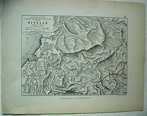
The Battle of Nivelle, Antique Battle Map from Alison's History of Europe Atlas 1789 -1815
Editore: William Blackwood & Sons, Edin. & London, 1875
This map shows The Battle of Nivelle on 10th November 1813. Depicted are the positions of the Allies and French, their cavalry, infantry and artillery; coloured red or blue according to nationality. The hand colouring is original , that is to say it dates to the publication of the atlas in 1875. The sheet measures 11 X 8.75 inches, the actual map from its borders measure approx. 6 X 8 inches. The map is by W. & A.K. Johnston, Edin. and the scale is about 1.25 inches to the mile.The map is in very good condition, and very clean with perhaps the just the odd spot here or there.
-
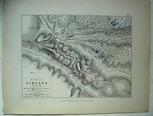
The Battle of Albuera, Antique Battle Map from Alison's History of Europe Atlas 1789 -1815
Editore: William Blackwood & Sons, Edin. & London, 1875
This map shows The Battle of Albuera on 16th May 1811. Depicted are the positions of the Allies: English, Spanish & Portugese and the French, their cavalry, infantry and artillery; coloured red or blue according to nationality. The hand colouring is original , that is to say it dates to the publication of the atlas in 1875. The sheet measures 11 X 8.75 inches, the actual map from its borders measure approx. 6 X 8 inches. The map is by W. & A.K. Johnston, Edin. and the scale is about 1.75 inches to the mile.The map is in very good condition, and very clean with perhaps the just the odd spot here or there.
-
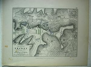
The Battle of Craone, Antique Battle Map from Alison's History of Europe Atlas 1789 -1815
Editore: William Blackwood & Sons, Edin. & London, 1875
This map shows The Battle of Craone on 7th March 1814. Depicted are the positions of the French and Russians their cavalry, infantry and artillery; coloured blue or green according to nationality. The hand colouring is original , that is to say it dates to the publication of the atlas in 1875. The sheet measures 11 X 8.75 inches, the actual map from its borders measure approx. 6 X 8 inches. The map is by W. & A.K. Johnston, Edin. and the scale is about 1.25 inches to the mile.The map is in very good condition, and very clean with perhaps the just the odd spot here or there.
-
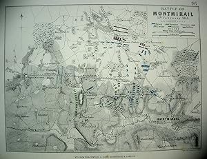
The Battle of Montmirail, Antique Battle Map from Alison's History of Europe Atlas 1789 -1815
Editore: William Blackwood & Sons, Edin. & London, 1875
This map shows The Battle of Montmirail on 11th February 1814. Depicted are the positions of the French. Russians and Prussians; their cavalry, infantry and artillery; coloured blue, green or mauve according to nationality. The hand colouring is original , that is to say it dates to the publication of the atlas in 1875. The sheet measures 11 X 8.75 inches, the actual map from its borders measure approx. 6 X 8 inches. The map is by W. & A.K. Johnston, Edin. and the scale is about 1.25 inches to the mile.The map is in very good condition, and very clean with perhaps the just the odd spot here or there.
-
The Battles of Champaubert & Vauchamps, Antique Battle Map from Alison's History of Europe Atlas 1789 -1815
Editore: William Blackwood & Sons, Edin. & London, 1875
This map shows The Battles of Champaubert & Vauchamps on 10th & 14th February 1814. Depicted are the positions of the French and the Allies; their cavalry, infantry and artillery; coloured blue and mauve according to nationality. The hand colouring is original , that is to say it dates to the publication of the atlas in 1875. The sheet measures 11 X 8.75 inches, the actual map from its borders measure approx. 6 X 8 inches. The map is by W. & A.K. Johnston, Edin. and the scale is about 1.5 inches to the mile.The map is in very good condition, and very clean with perhaps the just the odd spot here or there.
-
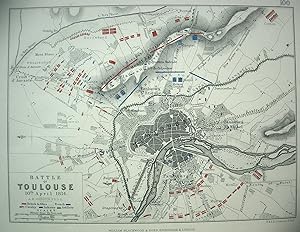
The Battle of Toulouse, Antique Battle Map from Alison's History of Europe Atlas 1789 -1815
Editore: William Blackwood & Sons, Edin. & London, 1875
This map shows The Battle of Toulouse on 10th April 1814. Depicted are the positions of the British & Allies and the French; their cavalry, infantry and artillery; coloured red and blue, according to nationality. The hand colouring is original , that is to say it dates to the publication of the atlas in 1875. The sheet measures 11 X 8.75 inches, the actual map from its borders measure approx. 6 X 8 inches. The map is by W. & A.K. Johnston, Edin. and the scale is about 1.45 inches to the mile.The map is in very good condition, and very clean with perhaps the just the odd spot here or there.
-
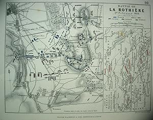
The Battle of La Rothiere, Antique Battle Map from Alison's History of Europe Atlas 1789 -1815
Editore: William Blackwood & Sons, Edin. & London, 1875
This map shows The Battle of La Rothiere on 1st February 1814. Depicted are the positions of the Allies and the French; their cavalry, infantry and artillery; coloured mauve and blue, according to nationality. Positions are shown beflore and after the battle. The hand colouring is original , that is to say it dates to the publication of the atlas in 1875. The sheet measures 11 X 8.75 inches, the actual map from its borders measure approx. 6 X 8 inches. A section of the map shows the part of France explanatory of the 1814 campaign.The map is by W. & A.K. Johnston, Edin. and the scale is about 1 inch to the mile.The map is in very good condition, and very clean with perhaps the just the odd spot here or there.
-
The Battles of Fere Champenoise and Arcis-Sur-Aube, Antique Battle Map from Alison's History of Europe Atlas 1789 -1815
Editore: William Blackwood & Sons, Edin. & London, 1875
This map shows The Battles of Fere Champenoise and also Arcis-Sur-Aube, on 25th & 21st March 1814. Depicted are the positions of the French and the Allies; their cavalry, infantry and artillery; coloured blue and mauve according to nationality. The hand colouring is original , that is to say it dates to the publication of the atlas in 1875. The sheet measures 11 X 8.75 inches, the actual map from its borders measure approx. 6 X 8 inches. The map is by W. & A.K. Johnston, Edin. and the scale is about 1.5 inches to the mile. Half the map is devoted to each battle.The sheet has a tear on the edge of the border of about an inch away from the actual map, otherwise it is in very good condition, and very clean with just a few spots here or there.
-
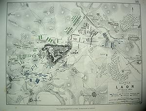
The Battle of Laon, Antique Battle Map from Alison's History of Europe Atlas 1789 -1815
Editore: William Blackwood & Sons, Edin. & London, 1875
This map shows The Battle of Laon on 9th March 1814. Depicted are the positions of the French, Prussians and Russians; their cavalry, infantry and artillery; coloured blue mauve or green according to nationality. The hand colouring is original , that is to say it dates to the publication of the atlas in 1875. The sheet measures 11 X 8.75 inches, the actual map from its borders measure approx. 6 X 8 inches. The map is by W. & A.K. Johnston, Edin. and the scale is about 1. inch to the mile.The map is in very good condition, and very clean with perhaps the just the odd spot here or there.
-
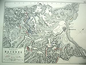
The Battle of Bayonne, Antique Battle Map from Alison's History of Europe Atlas 1789 -1815
Editore: William Blackwood & Sons, Edin. & London, 1875
This map shows The Battle of Bayonne on 10th-13th December 1813. Depicted are the positions of the Allies and French; their cavalry, infantry and artillery; coloured red or blue according to nationality.The hand colouring is original , that is to say it dates to the publication of the atlas in 1875. The sheet measures 11 X 8.75 inches, the actual map from its borders measure approx. 6 X 8 inches. The map is by W. & A.K. Johnston, Edin. and the scale is about .75 inches to the mile.The map is in very good condition, there is foxing to the back of the map with some spots showing through here and there.
-
Paris and Its Environs to illustrateThe Battle of Paris 1814, Antique Battle Map from Alison's History of Europe Atlas 1789 -1815
Editore: William Blackwood & Sons, Edin. & London, 1875
This map shows Paris and its environs to illustrate the Battle of Paris on 30th March 1814. Depicted are the positions of the French and the Allies ; their cavalry, infantry and artillery; coloured blue and mauve, according to nationality. There is also an inset map showing the country around Paris.The hand colouring is original , that is to say it dates to the publication of the atlas in 1875. The sheet measures 11 X 8.75 inches, the actual map from its borders measures approx. 6 X 8 inches. The map is by W. & A.K. Johnston, Edin. and the scale is about .6 inches to the mile.The map is in very good condition, and mostly very clean with some foxing although most of it confined to the border.
-
Map of Parts of France & Belgium to Illustrate the Campaigns of 1814-15, Antique Battle Map from Alison's History of Europe Atlas 1789 -1815
Editore: William Blackwood & Sons, Edin. & London, 1875
This map shows parts of France & Belgium to Illustrate the Campaigns of 1814-15. The map is hand coloured in red and blue, with the sites of battles underlined in red.The hand colouring is original , that is to say it dates to the publication of the atlas in 1875. The sheet measures 11 X 8.75 inches, the actual map from its borders measures approx. 6 X 8 inches. The map is by W. & A.K. Johnston, Edin. and the scale is about 20 miles to one inch.The map is in very good condition, and very clean with a little foxing although most of it confined to the border, and one very small edge tear well away from the actual map.
-
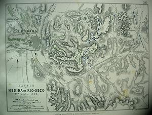
The Battle of Medina De Rio-Seco, Antique Battle Map from Alison's History of Europe Atlas 1789 -1815
Editore: William Blackwood & Sons, Edin. & London, 1875
This map shows The Battle of Medina De Rio-Seco on 14th July 1808. Depicted are the positions of the French and Spanish; their cavalry, infantry and artillery; coloured blue and green, according to nationality. The hand colouring is original , that is to say it dates to the publication of the atlas in 1875. The sheet measures 11 X 8.75 inches, the actual map from its borders measures approx. 6 X 8 inches. The map is by W. & A.K. Johnston, Edin. and the scale is about 2. inches to the mile.The map is in very good condition, there is some adhesive remaining along the extreme left of the sheet where it was removed from its binding, this is well away from the actual map and would easily disappear when mounted. Otherwise the sheet is mostly quite clean with perhaps the just the odd spot here or there.
-
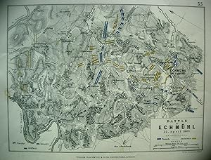
The Battle of Echmuhl, Antique Battle Map from Alison's History of Europe Atlas 1789 -1815
Editore: William Blackwood & Sons, Edin. & London, 1875
This map shows The Battle of Echmuhl on 22nd April 1809. Depicted are the positions of the French the Austrians; their cavalry, infantry and artillery; coloured blue and yellow, according to nationality. The hand colouring is original , that is to say it dates to the publication of the atlas in 1875. The sheet measures 11 X 8.75 inches, the actual map from its borders measures approx. 6 X 8 inches. The map is by W. & A.K. Johnston, Edin. and the scale is about 2. miles to the inch.The map is in very good condition, although the extreme left of the sheet is ragged where it was removed from its binding, this is well away from the actual map and would easily disappear when mounted. Otherwise the sheet is mostly quite clean with perhaps a few spots here and there.
-
The Battle of Vimeira, Antique Battle Map from Alison's History of Europe Atlas 1789 -1815
Editore: William Blackwood & Sons, Edin. & London, 1875
This map shows The Battle of Vimeira on 21st August 1808. Depicted are the positions of the Allies and the French; their cavalry, infantry and artillery; coloured red and blue, according to nationality. The hand colouring is original , that is to say it dates to the publication of the atlas in 1875. The sheet measures 11 X 8.75 inches, the actual map from its borders measures approx. 6 X 8 inches. The map is by W. & A.K. Johnston, Edin. and the scale is about 1.5 inches to the mile.The map is in very good condition, there is some adhesive remaining along the extreme left of the sheet where it was removed from its binding, this is well away from the actual map and would easily disappear when mounted. Otherwise the sheet is mostly quite clean with perhaps the just the odd spot here or there.
-
The Battle of Ocana, Antique Battle Map from Alison's History of Europe Atlas 1789 -1815
Editore: William Blackwood & Sons, Edin. & London, 1875
This map shows The Battle of Ocana on 19th November 1809. Depicted are the positions of the French and Spanish; their cavalry, infantry and artillery; coloured red and blue, according to nationality. The hand colouring is original , that is to say it dates to the publication of the atlas in 1875. The sheet measures 11 X 8.75 inches, the actual map from its borders measures approx. 6 X 8 inches. The map is by W. & A.K. Johnston, Edin. and the scale is about 1. inch to the mile.The map is in very good condition, there is a little surface tearing at the extreme left of the sheet where it was removed from its binding, this is well away from the actual map and would easily disappear when mounted. Otherwise the sheet is mostly quite clean with perhaps the just the odd spot here or there.
-
The Battle of Hanau, Antique Battle Map from Alison's History of Europe Atlas 1789 -1815
Editore: William Blackwood & Sons, Edin. & London, 1875
This map shows The Battle of Hanau on 30th October 1813. Depicted are the positions of the the French and the Bavarians & Austrians; their cavalry, infantry and artillery; coloured blue and yellow, according to nationality. The hand colouring is original , that is to say it dates to the publication of the atlas in 1875. The sheet measures 11 X 8.75 inches, the actual map from its borders measures approx. 6 X 8 inches. The map is by W. & A.K. Johnston, Edin. and the scale is about 4 inches to the mile.The map is in very good condition, and the sheet is very clean with perhaps the just the odd spot here or there.
-
The Battle of the Katzbach, Antique Battle Map from Alison's History of Europe Atlas 1789 -1815
Editore: William Blackwood & Sons, Edin. & London, 1875
This map shows The Battle of the Katzbach on 26th August 1813. Depicted are the positions of the the French and the Russians & Prussians; their cavalry, infantry and artillery; coloured blue, green or mauve, according to nationality. The hand colouring is original , that is to say it dates to the publication of the atlas in 1875. The sheet measures 11 X 8.75 inches, the actual map from its borders measures approx. 6 X 8 inches. The map is by W. & A.K. Johnston, Edin. and the scale is about .8 inches to the mile.The map is in very good condition, and the sheet is very clean with perhaps the just the odd spot here or there.
-
The Battle of Dresden, Antique Battle Map from Alison's History of Europe Atlas 1789 -1815
Editore: William Blackwood & Sons, Edin. & London, 1875
This map shows The Battle of Dresden on 26th & 27th August 1813. Depicted are the positions of the the Austrians, Russians, Prussians and French; their cavalry, infantry and artillery; coloured yellow, mauve, green and blue, according to nationality. The hand colouring is original , that is to say it dates to the publication of the atlas in 1875. The sheet measures 11 X 8.75 inches, the actual map from its borders measures approx. 6 X 8 inches. The map is by W. & A.K. Johnston, Edin. and the scale is about .9 inches to the mile.The map is in very good condition, and the sheet is very clean with perhaps the just the odd spot here or there.
-
The Siege of St Sebastian, Antique Battle Map from Alison's History of Europe Atlas 1789 -1815
Editore: William Blackwood & Sons, Edin. & London, 1875
This map shows The Siege of St Sebastian by the Allies under Wellington from June to September 1813. Depicted are the positions of the allied forces; coloured red. The hand colouring is original , that is to say it dates to the publication of the atlas in 1875. The sheet measures 11 X 8.75 inches, the actual map from its borders measures approx. 6 X 8 inches. The map is by W. & A.K. Johnston, Edin. and the scale is about 3 inches to the mile.The map is in very good condition, and the sheet is very clean with perhaps the just the odd spot here or there.
-
The Battle of Lutzen, Antique Battle Map from Alison's History of Europe Atlas 1789 -1815
Editore: William Blackwood & Sons, Edin. & London, 1875
This map shows The Battle of Lutzen on 2nd May 1813. Depicted are the positions of the the Allies and French; their cavalry, infantry and artillery; coloured mauve and blue, according to nationality. The hand colouring is original , that is to say it dates to the publication of the atlas in 1875. The sheet measures 11 X 8.75 inches, the actual map from its borders measures approx. 6 X 8 inches. The map is by W. & A.K. Johnston, Edin. and the scale is about 1 inch to the mile.The map is in very good condition, and is mostly quite clean with the just the odd spot here or there.
-
The Battle of Borodino, Antique Battle Map from Alison's History of Europe Atlas 1789 -1815
Editore: William Blackwood & Sons, Edin. & London, 1875
This map shows The Battle of Borodino on 7th September 1812. Depicted are the positions of the French and Russians; their cavalry, infantry and artillery; coloured blue and green, according to nationality. The hand colouring is original , that is to say it dates to the publication of the atlas in 1875. The sheet measures 11 X 8.75 inches, the actual map from its borders measures approx. 6 X 8 inches. The map is by W. & A.K. Johnston, Edin. and the scale is about .9 inches to the mile.The map is in very good condition, and is mostly quite clean with the just the odd spot here or there.
-
The Battle of Maro-Jaroslawitz, Antique Battle Map from Alison's History of Europe Atlas 1789 -1815
Editore: William Blackwood & Sons, Edin. & London, 1875
This map shows The Battle of Malo-Jaroslawitz on 24th Octoberr 1812. Depicted are the positions of the French and Russians; their cavalry, infantry and artillery; coloured blue and green, according to nationality. The hand colouring is original , that is to say it dates to the publication of the atlas in 1875. The sheet measures 11 X 8.75 inches, the actual map from its borders measures approx. 6 X 8 inches. The map is by W. & A.K. Johnston, Edin. and the scale is about 1.6 inches to the mile.The map is in very good condition, and is mostly quite clean with the just the odd spot here or there.
-
The Siege of Gerona, Antique Battle Map from Alison's History of Europe Atlas 1789 -1815
Editore: William Blackwood & Sons, Edin. & London, 1875
This map shows The Siege of Gerona by the French Army of Catalonia from May to October 1809. Depicted are the positions of the French batteries; coloured blue. The hand colouring is original , that is to say it dates to the publication of the atlas in 1875. The sheet measures 11 X 8.75 inches, the actual map from its borders measures approx. 6 X 8 inches. The map is by W. & A.K. Johnston, Edin. and the scale is about 2.5 inches to the mile.The sheet has some surface tearing and a ragged edge on the extreme left of the sheet where it was removed from its binding, although it is well away from the actual map and will disappear easily once the map is mounted.
-
The Battles of Smolensko and Valtelina, Antique Battle Map from Alison's History of Europe Atlas 1789 -1815
Editore: William Blackwood & Sons, Edin. & London, 1875
This map shows The Battles of Smolensko and Valtelina on 17th,18th & 19th August 1812. Depicted are the positions of the French and Russians; their cavalry, infantry and artillery; coloured blue and green, according to nationality. The hand colouring is original , that is to say it dates to the publication of the atlas in 1875. The sheet measures 11 X 8.75 inches, the actual map from its borders measures approx. 6 X 8 inches. The map is by W. & A.K. Johnston, Edin. and the scale is about 1.6 inches to the mile.The map is in very good condition, and is mostly quite clean with the just the odd spot here or there.
-
The Battle of Culm , Antique Battle Map from Alison's History of Europe Atlas 1789 -1815
Editore: William Blackwood & Sons, Edin. & London, 1875
This map shows The Battle of Culm 29th August 1813. Depicted are the positions of the French and Allies; their cavalry, infantry and artillery; coloured blue and mauve, according to nationality. The hand colouring is original , that is to say it dates to the publication of the atlas in 1875. Half the map shows the battle and the area around Culm, the other half of the map shows Saxony, part of Prussia with Lutzen, Lepzig, Dresden , Culm etc. marked. The sheet measures 11 X 8.75 inches, the actual map from its borders measures approx. 6 X 8 inches. The map is by W. & A.K. Johnston, Edin. and the scale of the battle map is about 1.25inches to the mile.The map is in very good condition, and is mostly quite clean with the just the odd spot here or there.