
Importo totale (1 articolo articoli):
Destinazione ordine:

william bell timothy osullivan (4 risultati)
Tipo di articolo
- Tutti i tipi di prodotto
- Libri (4)
- Riviste e Giornali
- Fumetti
- Spartiti
- Arte, Stampe e Poster
- Fotografie
- Mappe
- Manoscritti e Collezionismo cartaceo
Condizioni
- Tutte
- Nuovi
- Antichi o usati (4)
Legatura
- Tutte
- Rilegato
- Brossura (1)
Ulteriori caratteristiche
- Prima ed.
- Copia autograf.
- Sovracoperta
- Con foto (3)
- Non Print on Demand (4)
Spedizione gratuita
- Spedizione gratuita negli USA
Paese del venditore
Valutazione venditore
-

Wheeler's Photographic Survey of the American West, 1871-1873
Editore: Dover Publications, New York, 1983
Libro
Soft cover. Condizione: Near Fine. No Jacket. 31 x 23.5 cm, [xi], 40 pp., 40 full page plates, pictorial brown, white and black stiff paper covers.
-
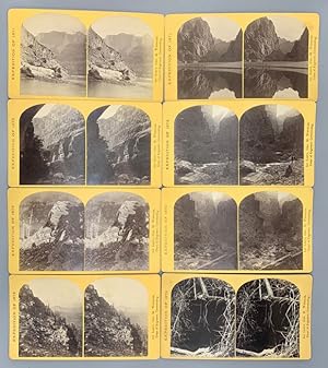
George M. Wheeler Survey Stereoview Collection. 20 Stereoviews
Editore: Geographical and Geological Explorations and Surveys West of the 100th Meridian, Washington DC, 1872
Da: Ken Sanders Rare Books, ABAA, Salt Lake City, UT, U.S.A.
Membro dell'associazione: ABAA ILAB IOBA RMABA
Valutazione venditore:

Albumen photographs [9.5 cm x 15 cm] on yellow Geo. M. Wheeler mounts [10 cm x 18 cm] each with a printed identification label on the verso. 18 views by Bell; 2 by O'Sullivan. The majority are in remarkably nice condition, displaying strong contrasts. Spectacular views from the Wheeler survey of the southwest with well focused images of the Grand Canyon, Kanab Creek, Black Canyon, Dirty Devil and Marble Canyon. These constitute some of the earliest images of these places. Timothy O'Sullivan worked on the Wheeler Survey after having achieved some notoriety for his Civil War photographs. The work which O'Sullivan produced during this time was later used as a means of persuading Congress to fund military rather than civilian expeditions. William H. Bell (1830-1910) was an English-born American photographer, who fought in the Civil War, and was mostly active during the second half of the 19th century. His Civil War views gained him much attention, and following the Civil War he was appointed chief photographer of the Army Medical Museum in Washington D. C. It was Bell and his assistants who printed the photographs that were featured on the "Wanted" posters for the Lincoln Conspirators, circulated following the assassination. Eventually, Bell set up a studio in Philadelphia, and in 1872, Lieutenant George Wheeler, engineer of the fourth United States Geological Survey, employed him to photograph his expedition into Arizona. Bell's images of the southwest taken during the 1872 Wheeler expedition served to strengthen his reputation as a photographer even further. Jeremy Rowe, in his book "Arizona Stereographs 1865-1930," writes with regards to the photography of this era, ". both surveys [Wheeler and Powell] produced and used the stereographs in their attempts to obtain congressional funding and for general promotion of the expedition to generate public interest and support. For example, Wheeler images were available as individual cards or as boxed sets of stereographs of the expedition." The 20 stereoviews presented here are examples of this promotional material. This lot includes the images listed below: [Expedition of 1871] No. 9. View down Black Canon from Mirror Bar. The walls repeated by reflection. [O'Sullivan] No. 15. View in the Grand Canon of the Colorado. Characteristic walls 5,000 feet in height. [O'Sullivan] [Expedition of 1872] No. 5. View in the high country, on the headwaters of the Dirty Devil River. The Rocks in the foreground are volcanic, and the trees are the Douglass spruce. [Bell] No. 7. View in the high country, on the headwaters of the Dirty Devil River. The rocks in the foreground are volcanic, and the trees are the Douglass spruce. [Bell] No. 9. Cave near Kanab, U.T. [Bell] No. 14. The Canon of Kanab Creek, near its junction with the Grand Canon of the Colorado. In the foreground is a dripping spring, affording a shower-bath. Temperature, 69° Fahr. [Bell] No. 16. The Canon of Kanab Creek, near its junction with the Grand Canon of the Colorado River. The walls are of limestone and about 2,500 feet in height. [Bell] No. 17. The Canon of Kanab Creek, near where it joins the Grand Canon of the Colorado. The walls are of limestone and about 2,500 feet in height. [Bell] No. 18. The Canon of Kanab Creek, near where it joins the Grand Canon of the Colorado. The walls are of limestone and about 2,000 feet in height. [Bell] No. 20. The Canon of Kanab Creek, near where it joins the Grand Canon of the Colorado. The walls are of limestone and about 2,500 feet in height. [Bell] No. 22. The mouth of Kanab Creek. The beds of the Colorado River and its tributary here lie in gorges cut by the running water to a depth of about 3,500 feet below the general surface of the country. The highest point seen in the picture is $2,500 feet above the water, and the walls are here too steep to be scaled. [Bell] No. 23. Sand sculpture. The limestone boulders which lie in the bed of the Colorado River are carved and polished by the sand which the running water carries. [Bell] No. 27. Colorado River, above the mouth of the Paria. Walls 2,100 feet in height. [Bell] No. 28. Marble Canon, one of the gorges of the Colorado, here 1,200 feet deep. The steep cliff is gray limestone and the slope below a brilliant red sandstone. [Bell] No. 29. Marble Canon, one of the gorges of the Colorado, here 1,200 feet deep. The steep cliff is gray limestone and the slope below a brilliant red sandstone. [Bell] No. 31. Devil's Anvil, near foot of To-ro-weap Valley. River 3,000 feet below. [Bell] No. 32. The northern wall of the Grand Canyon of the Colorado, near the foot of To-ro-weap Valley. The rounded rocks of the foreground are sandstone. [Bell] No. 35. The Grand Canon of the Colorado, near the foot of To-ro-weap Valley. A view of the south wall of the gorge, as seen from the opposite side. [Bell] No. 38. The Grand Canon of the Colorado, near the foot of To-ro-weap Valley. A view of the south wall of the gorge, as seen from the opposite wall. [Bell] No. 39. Grand Canon, foot of To-ro-weap Valley. [Bell].
-
[Photographs Showing Landscapes, Geological and Other Features of Portions of the Western Territory of the United States]
Editore: [Washington, D.C., 1875
Da: Donald A. Heald Rare Books (ABAA), New York, NY, U.S.A.
Membro dell'associazione: ABAA ILAB
Valutazione venditore:

6 albumen photographs, each mounted on two-toned Wheeler Survey mount with letterpress imprints and titles. Scarce O'Sullivan and Bell photographs from the landmark Wheeler Surveys. A collection of six rare Wheeler Survey images featuring Colorado and Idaho from the 1874 season. These images therefore were not included in the 50 plate set of images from the 1871 and 1873 season, and so are not included in the Dover Publications work on that set published in 1983. The survey's main goal was to make topographic maps of the southwestern United States and the present series of images focuses on the landscapes of this region. The collection comprises the following subjects (with series identification numbers): 1) "Lake in Conejos Canon, Col." Not in Dover (IV:16). 2) "View Near Head of Conejos River, Col." Not in Dover (IV:17). 3) "Park Near Head Of Conejos Cańon, Col." Not in Dover (IV:18). 4) "'Lost' Lakes Near Miegs Peak, Col., Lakes 9,500 feet above sea-level." Not in Dover (IV:19). 5) "Alpine Lake, Cerro Blanco Mountains, Col. Height of Peak over 14,000 feet." Not in Dover (IV:20). 6) "Snake River Canon, Idaho. View from above Shoshone Falls." Not in Dover (IV:25). The Irish-born O'Sullivan's pioneering photographic work started during the American Civil War when he served as Matthew Brady's apprentice and then through his work in Alexander Gardener's studio. He afterwards became the official photographer on the United States Geological Exploration of the Fortieth Parallel under Clarence King from 1867-1869. In 1870 he joined a survey team in Panama to survey for a canal across the isthmus. He joined Lt.George M. Wheeler's survey west of the 100th meridian west from 1871-74, facing starvation on the Colorado River when some of the expedition's boats capsized. Only a small percentage of the 300 negatives he took survived the trip back East. He spent the last years of his short life in Washington, D.C., as official photographer for the U.S. Geological Survey and the Treasury Department. For his Wheeler Survey photographs, the English-born Bell used two cameras: an 11 x 8-inch camera for large prints, and an 8 x 5 inch for stereo cards. He employed both wet and dry collodion processes on this expedition. As a result, these photographs are characterized by dark foregrounds with elements becoming increasingly lighter in tone as distances increase. All of the photographs were taken during the series of expeditions known by the collective title of the "Geographical Surveys West of the 100th Meridian" (or more usually as the Wheeler Survey after its leader, Lieutenant George M. Wheeler). The photographs document the work and explorations of the survey, and include some of the earliest photographs taken of the Grand Canyon and of Indian tribes and sites in northern Arizona and New Mexico. A number of these images have achieved iconic status among the images of the early West. "The survey that produced the photographs.was led by George M. Wheeler, a native of Hopkinton, Massachusetts. Born in 1842, Wheeler began his [Army] career in topographical engineering in 1867.His early reconnaissance work in Nevada and Utah convinced him of the need for a new survey, comparable in scale to those of [Clarence] King, [Ferdinand Vandiveer] Hayden and [John Wesley] Powell.Wheeler's proposal met with a favorable reception in Washington" - GEORGE M. WHEELER'S PHOTOGRAPHIC SURVEY OF THE AMERICAN WEST, 1871-1873 (pp.v-vi). The survey took place over four seasons in 1871-1874. The photographer in 1871, 1873and 1874 was Timothy O'Sullivan, "born around 1840, probably in Ireland. Little is known of his early life on Staten Island, New York. As a teenager, he apprenticed himself to Mathew B. Brady, one of the outstanding American photographers of the nineteenth century.The expeditionary phase of O'Sullivan's professional life began in 1867 with the King survey 'and in 1870 he served as official photographer for an expedition to the Isthmus of Darien to map o.
-
[Photographs Showing Landscapes, Geological and Other Features of Portions of the Western Territory of the United States]
Editore: [Washington, D.C., 1875
Da: Donald A. Heald Rare Books (ABAA), New York, NY, U.S.A.
Membro dell'associazione: ABAA ILAB
Valutazione venditore:
9 albumen photographs, each mounted on two-toned Wheeler Survey mount with letterpress imprints and titles. Scarce O'Sullivan and Bell photographs from the landmark Wheeler Surveys. A collection of nine rare Wheeler Survey images, mostly featuring sites in Arizona. The survey's main goal was to make topographic maps of the southwestern United States and the present series of images focuses on the landscapes of this region. The collection contains images from each of the first three years of the Survey, and comprises the following subjects (with series identification numbers): 1) "Snow Peaks, Bull Run Mining District, Nevada 1871." Dover 1 (I:1). 2) "Cańon Of Kanab Wash, Colorado River, Looking South." Dover 1 (II:1). 3) "Grand Canon, Colorado River, Near Paria Creek, Looking West." Dover 23 (II:7, numbered 5 on photo). 4) "Apache Lake, Sierra Blanca Range, Arizona." Not on U.S. Army Corps Engineers mount. Dover 32 (III:1). 5) "View on Apache Lake, Sierra Blanca Range, Arizona." Dover 33 (III:2). 6) "View on Apache Lake, Sierra Blanca Range, Arizona, Two Apache Scouts in the Foreground." Dover 34 (III:3). 7) "North Fork Cańon, Sierra Blanca Creek, Arizona 1873." Dover 35 (III:4). 8) "Cooley's Park, Sierra Blanca Range, Arizona." Dover 36 (III:5). 9) "Distant View of Camp Apache, Arizona 1873." Dover 37 (III:6). The Irish-born O'Sullivan's pioneering photographic work started during the American Civil War when he served as Matthew Brady's apprentice and then through his work in Alexander Gardener's studio. He afterwards became the official photographer on the United States Geological Exploration of the Fortieth Parallel under Clarence King from 1867-1869. In 1870 he joined a survey team in Panama to survey for a canal across the isthmus. He joined Lt.George M. Wheeler's survey west of the 100th meridian west from 1871-74, facing starvation on the Colorado River when some of the expedition's boats capsized. Only a small percentage of the 300 negatives he took survived the trip back East. He spent the last years of his short life in Washington, D.C., as official photographer for the U.S. Geological Survey and the Treasury Department. For his Wheeler Survey photographs, the English-born Bell used two cameras: an 11 x 8-inch camera for large prints, and an 8 x 5 inch for stereo cards. He employed both wet and dry collodion processes on this expedition. As a result, these photographs are characterized by dark foregrounds with elements becoming increasingly lighter in tone as distances increase. All of the photographs were taken during the series of expeditions known by the collective title of the "Geographical Surveys West of the 100th Meridian" (or more usually as the Wheeler Survey after its leader, Lieutenant George M. Wheeler). The photographs document the work and explorations of the survey, and include some of the earliest photographs taken of the Grand Canyon and of Indian tribes and sites in northern Arizona and New Mexico. A number of these images have achieved iconic status among the images of the early West. "The survey that produced the photographs.was led by George M. Wheeler, a native of Hopkinton, Massachusetts. Born in 1842, Wheeler began his [Army] career in topographical engineering in 1867.His early reconnaissance work in Nevada and Utah convinced him of the need for a new survey, comparable in scale to those of [Clarence] King, [Ferdinand Vandiveer] Hayden and [John Wesley] Powell.Wheeler's proposal met with a favorable reception in Washington" - George M. Wheeler's Photographic Survey of the American West, 1871-1873 (pp.v-vi). The survey took place over three seasons in 1871, 1872, and 1873. The photographer in 1871 and 1873 was Timothy O'Sullivan, "born around 1840, probably in Ireland. Little is known of his early life on Staten Island, New York. As a teenager, he apprenticed himself to Mathew B. Brady, one of the outstanding American photographers of the nineteenth century.The expeditionary phase of O'Sullivan.

![Immagine del venditore per [Photographs Showing Landscapes, Geological and Other Features of Portions of the Western Territory of the United States] venduto da Donald A. Heald Rare Books (ABAA)](https://pictures.abebooks.com/inventory/md/md30456054653.jpg)
![Immagine del venditore per [Photographs Showing Landscapes, Geological and Other Features of Portions of the Western Territory of the United States] venduto da Donald A. Heald Rare Books (ABAA)](https://pictures.abebooks.com/inventory/md/md30456055234.jpg)