
Importo totale (1 articolo articoli):
Destinazione ordine:

world map burke howard (2 risultati)
Vai alla pagina principale dei risultati di ricerca
Filtri di ricerca
Tipo di articolo
- Tutti i tipi di prodotto
- Libri (2)
- Riviste e Giornali (Nessun altro risultato corrispondente a questo perfezionamento)
- Fumetti (Nessun altro risultato corrispondente a questo perfezionamento)
- Spartiti (Nessun altro risultato corrispondente a questo perfezionamento)
- Arte, Stampe e Poster (Nessun altro risultato corrispondente a questo perfezionamento)
- Fotografie (Nessun altro risultato corrispondente a questo perfezionamento)
- Mappe (Nessun altro risultato corrispondente a questo perfezionamento)
- Manoscritti e Collezionismo cartaceo (Nessun altro risultato corrispondente a questo perfezionamento)
Condizioni Maggiori informazioni
- Nuovo (Nessun altro risultato corrispondente a questo perfezionamento)
- Come nuovo, Ottimo o Quasi ottimo (Nessun altro risultato corrispondente a questo perfezionamento)
- Molto buono o Buono (Nessun altro risultato corrispondente a questo perfezionamento)
- Discreto o Mediocre (Nessun altro risultato corrispondente a questo perfezionamento)
- Come descritto (2)
Legatura
- Tutte
- Rilegato (Nessun altro risultato corrispondente a questo perfezionamento)
- Brossura (Nessun altro risultato corrispondente a questo perfezionamento)
Ulteriori caratteristiche
- Prima ed. (Nessun altro risultato corrispondente a questo perfezionamento)
- Copia autograf. (Nessun altro risultato corrispondente a questo perfezionamento)
- Sovracoperta (Nessun altro risultato corrispondente a questo perfezionamento)
- Con foto (2)
- Non Print on Demand (2)
Lingua (1)
Prezzo
- Qualsiasi prezzo
- Inferiore a EUR 20 (Nessun altro risultato corrispondente a questo perfezionamento)
- EUR 20 a EUR 45 (Nessun altro risultato corrispondente a questo perfezionamento)
- Superiore a EUR 45
Spedizione gratuita
- Spedizione gratuita in U.S.A. (Nessun altro risultato corrispondente a questo perfezionamento)
Paese del venditore
Valutazione venditore
-
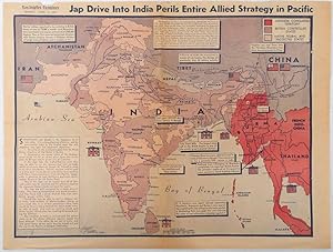
Jap Drive into India perils entire Allied strategy in Pacific
Editore: Los Angeles Examiner. April 31944., Los Angeles.
Da: Asia Bookroom ANZAAB/ILAB, Canberra, ACT, Australia
Membro dell'associazione: ANZAAB ILAB
Valutazione del venditore 5 su 5 stelle

EUR 409,21
Spedizione EUR 26,04
Spedito da Australia a U.S.A.Quantit�: 1 disponibili
Aggiungi al carrelloColour pictorial map on a single newspaper leaf 37 x 50 cms; 41.5 x 54.6 cms (sheet), unrelated text on the verso (although with an interesting account from a soldier's letter about an air raid in China), toning, more marked at the central fold (two small splits, no loss to the map), edge wear with several small marginal edge tears neatly repaired on the verso with archival washi (map unaffected), in good condition. A dynamic map prepared and illustrated by the Examiner's art critic and editor Howard Burke, covering the area surrounding India and Central Asia showing Japanese conquered territory in Malaya, Thailand, Indo-China and Burma; and in India British-controlled states and native feudal and protected states. Text boxes and pictographs give an overview of the geopolitical situation, from the Allied perspective. One box notes "Chanda Bose has many adherents and fanatical followers in Bengal. They may prove to be a powerful fifth column in India". Text at lower edge opines "The situation in India is critical and has grown more so as the all-out offensive against Japan has been delayed. If the Allies do not act at once, and with great force, all our gains may be wiped out and the war in the Pacific prolonged indefinitely." The decisive and devastating bombings that were to signal such an end were four months away. Rare on the market.
-
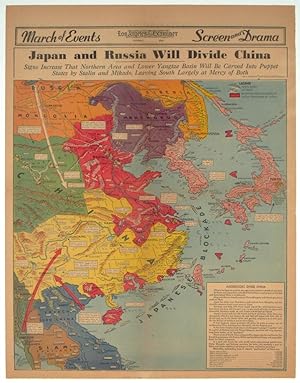
Japan and Russia Will Divide China. Signs Increase That Northern Area and Lower Yangtze Basin Will be Carved Into Puppet States by Stalin and Mikado, Leaving South Largely at Mercy of Both.
Editore: Los Angeles Examiner., Los Angeles., 1940
Da: Asia Bookroom ANZAAB/ILAB, Canberra, ACT, Australia
Membro dell'associazione: ANZAAB ILAB
Valutazione del venditore 5 su 5 stelle
EUR 786,94
Spedizione EUR 26,04
Spedito da Australia a U.S.A.Quantit�: 1 disponibili
Aggiungi al carrelloPrinted colour pictorial map on a single newspaper leaf, 42.3 x 39.9 cms; 54.3 x 42.5 cms (sheet), archivally laid down on linen, slight discoloration to lower centrefold and sheet slightly age-toned, but in very good condition. A striking geopolitical map by Los Angeles Examiner artist Howard Burke covering China, Japan, Southern Russia and the northern part of French Indochina and Siam, showing how the "Aggressors Divide China." Areas under Japanese occupation are shown in red, and their naval blockade shown by an arc of naval vessels, with vivid arrows indicating lines of supply. Text labels (including sources of agricultural and raw materials) provide a dynamic overview of the geopolitical situation, and show the influence of American scientific illustrator and cartographer Richard Edes Harrison who argued for examining geographic issues from multiple perspectives , and Los Angeles Times artist Charles Owens.