
Importo totale (1 articolo articoli):
Destinazione ordine:

robert christopher pub (45 risultati)
Vai alla pagina principale dei risultati di ricerca
Tipo di articolo
- Tutti gli articoli
- Libri (45)
- Riviste e Giornali
- Fumetti
- Spartiti
- Arte, Stampe e Poster
- Fotografie
- Mappe
-
Manoscritti e
Collezionismo cartaceo
Condizioni
Legatura
Ulteriori caratteristiche
- Prima edizione
- Copia autografata
- Sovraccoperta
- Con foto (19)
- No print on demand
Paese del venditore
Valutazione venditore
-
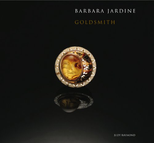
Barbara Jardine, Goldsmith
Editore: Robert and Christopher Publishers, 2006
ISBN 10: 9768194790ISBN 13: 9789768194794
Libro
Condizione: Good. Missing dust cover, otherwise book is in good condition with some wear from normal use.
Ulteriori offerte da altri venditori AbeBooks
Nuovo - A partire da EUR 76,72
Usato - A partire da EUR 17,19
Scopri anche Rilegato
-
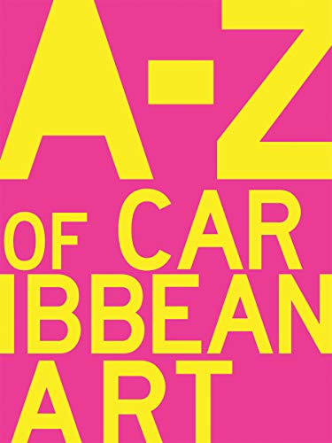
A to Z of Caribbean Art
Editore: Robert & Christopher Publishers, 2019
ISBN 10: 9769534498ISBN 13: 9789769534490
Libro
Paperback. Condizione: Near Fine. A Good Read ships from Toronto and Niagara Falls, NY - customers outside of North America please allow two to three weeks for delivery. ; 7.6 X 1 X 9.9 inches; 304 pages.
Ulteriori offerte da altri venditori AbeBooks
Nuovo - A partire da EUR 42,67
Usato - A partire da EUR 33,70
Scopri anche Brossura
-
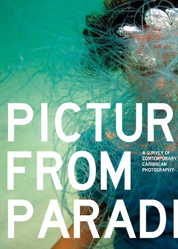
PICTURES FROM PARADISE: A SURVEY OF CONTEMPORARY CARIBBEAN PHOTOGRAPHY.; Editors:. ; Essay by O'Neil Lawrence
Editore: Robert and Christopher Publishers, Trinidad & Tobago, 2012
ISBN 10: 9769534471ISBN 13: 9789769534476
Da: Howard Karno Books, Inc., Valley Center, CA, U.S.A.
Membro dell'associazione: ABAA ILAB
Valutazione venditore:

Libro
b/w and color plates, ports., cat., bios/chrons., ind., color pict. fldg. wrps. 18 remarkable photographers from the English-speaking Caribbean (Jamaica, St. Vincent and The Grenadines, Trinidad & Tobago, St. Kitts & Nevis, Guyana, Bermuda and Barbados) featuring the work of Ewan Atkinon, Renee Cox, O'Neil Lawrance, Ebony G. Patterson, Marvin Bartley, Marlon James and Radcliff Roye amongst others. Includes works by works by Holly Bynoe and Nadia Contents: Huggins, the editors of ARC Magazine, a Caribbean art and culture serial publication. Featured photographer O'Neil Lawrence explains "many of the stories told in this book include the concepts of memory, interrogations of the past, the sometimes gritty and violent realities of modern urban Caribbean life, sexualities and transformed gender roles, and the religious practices that define us, either through adherence or rejection"-Verso cover. Contents: Introduction / Melanie Arher and Mariel Brown -- Beyond constructive realities / O'Neil Lawrence -- Works -- Tableaux Vivant -- Documentary -- Transformed media -- Portraiture -- About the artists -- Index of Works.
Ulteriori offerte da altri venditori AbeBooks
Usato - A partire da EUR 44,62
-

A Map of Zaara. Negroe-Land. Guinea
Editore: Artist: Moll Hermann ( - 1732 ) London ; issued in: Paris ; ca: 1719; - Hermann Moll (1654- 1732) London was a cartographer engraver and publisher Moll produced his earliest maps from studying cartographers such as John Senex and Emanuel Bowen_ In the 1690s Moll worked mainly as an engraver for Christopher Browne Robert Morden and Lea in whose business he was also involved During this time he also published his first major independent work the Thesaurus Geographicus The success of this work likely influenced his decision to start publishing his own maps For the production of his maps Moll relied on the most accurate geographical information possible from first hand Moll benefited from his acquaintance with circumnavigator and privateer Will, 1654
Da: Antique Sommer& Sapunaru KG, München, Germania
Membro dell'associazione: ILAB VDA
Valutazione venditore:
Technic: Copper print; colorit: colored; condition: Perfect condition, size (in cm): 17 x 19,5 cm; - Map shows the region of West Africa and a partial map with Cape Verde. At that time, this region in West Africa was called Nigrites (English Negroland, French Nigritie, Latin Nigritia). Of the western part of Africa, the coastal regions had been explored somewhat more thoroughly, while little was known about the interior. Thus Negroe Land corresponds to the imagination of European cartographers.
-
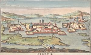
Sigeth.
Editore: Artist: Moll Hermann ( - 1732 ) London ; issued in: London ; ca: 1712; - Hermann Moll (1654- 1732) London was a cartographer engraver and publisher Moll produced his earliest maps from studying cartographers such as John Senex and Emanuel Bowen_ In the 1690s Moll worked mainly as an engraver for Christopher Browne Robert Morden and Lea in whose business he was also involved During this time he also published his first major independent work the Thesaurus Geographicus The success of this work likely influenced his decision to start publishing his own maps For the production of his maps Moll relied on the most accurate geographical information possible from first hand Moll benefited from his acquaintance with circumnavigator and privateer Wil, 1654
Da: Antique Sommer& Sapunaru KG, München, Germania
Membro dell'associazione: ILAB VDA
Valutazione venditore:
Technic: Copper print; colorit: original colored; condition: Margins cutted, size (in cm): 18 x 13 ,5; - Szietvar is a town in Baranya County in southern Hungary. The town's fortress was the setting of the Battle of Szigetvár in 1566. It was a sanjak centre at first in Budin Province (1566?1601), later in Kanije Province (1601?1689).
-
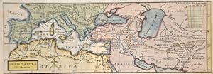
Orbis Tabula ad Justimum
Editore: Artist: Moll Hermann ( - 1732 ) London ; issued in: London ; ca: 1715; - Hermann Moll (1654- 1732) London was a cartographer engraver and publisher Moll produced his earliest maps from studying cartographers such as John Senex and Emanuel Bowen_ In the 1690s Moll worked mainly as an engraver for Christopher Browne Robert Morden and Lea in whose business he was also involved During this time he also published his first major independent work the Thesaurus Geographicus The success of this work likely influenced his decision to start publishing his own maps For the production of his maps Moll relied on the most accurate geographical information possible from first hand Moll benefited from his acquaintance with circumnavigator and privateer Wil, 1654
Da: Antique Sommer& Sapunaru KG, München, Germania
Membro dell'associazione: ILAB VDA
Valutazione venditore:
Technic: Copper print; colorit: colored; condition: Upper margin perfectly replaced, size (in cm): 8,5 x 25,5; - Map shows the Mediterranean sea with sout Europe, north Africa and Asia minor.
-
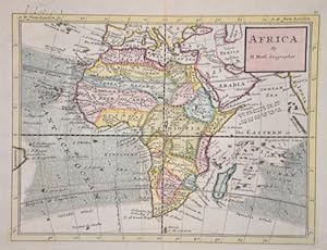
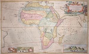
Africa. By H. Moll Geographer.
Editore: Artist: Moll Hermann ( - 1732 ) London ; issued in: London ; ca: 1714; - Hermann Moll (1654- 1732) London was a cartographer engraver and publisher Moll produced his earliest maps from studying cartographers such as John Senex and Emanuel Bowen_ In the 1690s Moll worked mainly as an engraver for Christopher Browne Robert Morden and Lea in whose business he was also involved During this time he also published his first major independent work the Thesaurus Geographicus The success of this work likely influenced his decision to start publishing his own maps For the production of his maps Moll relied on the most accurate geographical information possible from first hand Moll benefited from his acquaintance with circumnavigator and privateer Wil, 1654
Da: Antique Sommer& Sapunaru KG, München, Germania
Membro dell'associazione: ILAB VDA
Valutazione venditore:
Technic: Copper print; colorit: original colored; condition: Perfect condition, size (in cm): 20 x 26; - Map depicts the continent of Africa and the winds at sea. With the island of Madagaskar and the Canaries islands.
-
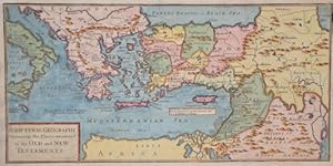
Scriptural Geography Containing the Places mentionednin the Old and New Testaments
Editore: Artist: Moll Hermann ( - 1732 ) London ; issued in: London ; ca: 1712; - Hermann Moll (1654- 1732) London was a cartographer engraver and publisher Moll produced his earliest maps from studying cartographers such as John Senex and Emanuel Bowen_ In the 1690s Moll worked mainly as an engraver for Christopher Browne Robert Morden and Lea in whose business he was also involved During this time he also published his first major independent work the Thesaurus Geographicus The success of this work likely influenced his decision to start publishing his own maps For the production of his maps Moll relied on the most accurate geographical information possible from first hand Moll benefited from his acquaintance with circumnavigator and privateer Wil, 1654
Da: Antique Sommer& Sapunaru KG, München, Germania
Membro dell'associazione: ILAB VDA
Valutazione venditore:
Technic: Copper print; colorit: original colored; condition: Lower right and upper left corner perfectly restored, size (in cm): 16 x 32,5; - Map shows the south eastern part of Europe and the Mediterranean sea with Italy, Greece, Turkey with Cyprus and north Africa, Egypt and Israel.
-
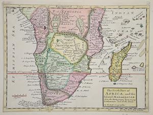
The South Part of Africa, and the Island Madagascar.
Editore: Artist: Moll Hermann ( - 1732 ) London ; issued in: London ; ca: 1700; - Hermann Moll (1654- 1732) London was a cartographer engraver and publisher Moll produced his earliest maps from studying cartographers such as John Senex and Emanuel Bowen_ In the 1690s Moll worked mainly as an engraver for Christopher Browne Robert Morden and Lea in whose business he was also involved During this time he also published his first major independent work the Thesaurus Geographicus The success of this work likely influenced his decision to start publishing his own maps For the production of his maps Moll relied on the most accurate geographical information possible from first hand Moll benefited from his acquaintance with circumnavigator and privateer Wil, 1654
Da: Antique Sommer& Sapunaru KG, München, Germania
Membro dell'associazione: ILAB VDA
Valutazione venditore:
Technic: Copper print; colorit: colored; condition: Perfect condition, size (in cm): 20,5 x 27,5 cm; - Map shows Southern Africa up to the equator with Madagascar, the Amirantes, Mauritius and Reunion Island in the Indian Ocean.
-
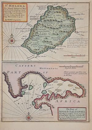
St. Helena / The bay of Agoa de Saldanha
Editore: Artist: Moll Hermann ( - 1732 ) London ; issued in: London ; ca: 1712; - Hermann Moll (1654- 1732) London was a cartographer engraver and publisher Moll produced his earliest maps from studying cartographers such as John Senex and Emanuel Bowen_ In the 1690s Moll worked mainly as an engraver for Christopher Browne Robert Morden and Lea in whose business he was also involved During this time he also published his first major independent work the Thesaurus Geographicus The success of this work likely influenced his decision to start publishing his own maps For the production of his maps Moll relied on the most accurate geographical information possible from first hand Moll benefited from his acquaintance with circumnavigator and privateer Wil, 1654
Da: Antique Sommer& Sapunaru KG, München, Germania
Membro dell'associazione: ILAB VDA
Valutazione venditore:
Technic: Copper print; colorit: original colored; condition: Very good, size (in cm): 27,5 x 20; - Map shows the island Saint Helena and the bay of Agoa Saldanha near the Cape of Good Hope.
-
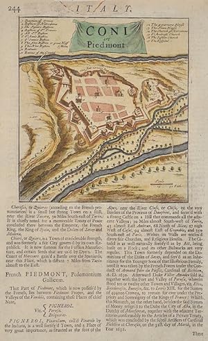
Coni in Piedmont
Editore: Artist: Moll Hermann ( - 1732 ) London ; issued in: London ; ca: 1705; - Hermann Moll (1654- 1732) London was a cartographer engraver and publisher Moll produced his earliest maps from studying cartographers such as John Senex and Emanuel Bowen_ In the 1690s Moll worked mainly as an engraver for Christopher Browne Robert Morden and Lea in whose business he was also involved During this time he also published his first major independent work the Thesaurus Geographicus The success of this work likely influenced his decision to start publishing his own maps For the production of his maps Moll relied on the most accurate geographical information possible from first hand Moll benefited from his acquaintance with circumnavigator and privateer Wil, 1654
Da: Antique Sommer& Sapunaru KG, München, Germania
Membro dell'associazione: ILAB VDA
Valutazione venditore:
Technic: Copper print; colorit: original colored; condition: Very good, size (in cm): 27 x 16 cm; - Map shows the plan of the city of Cuneo in Piedmont.
-
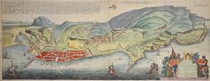
A New and Exact plan of Gibraltar with all its fortifications as they are at present.
Editore: Artist: Moll Hermann ( - 1732 ) London ; issued in: London ; ca: 1711; - Hermann Moll (1654- 1732) London was a cartographer engraver and publisher Moll produced his earliest maps from studying cartographers such as John Senex and Emanuel Bowen_ In the 1690s Moll worked mainly as an engraver for Christopher Browne Robert Morden and Lea in whose business he was also involved During this time he also published his first major independent work the Thesaurus Geographicus The success of this work likely influenced his decision to start publishing his own maps For the production of his maps Moll relied on the most accurate geographical information possible from first hand Moll benefited from his acquaintance with circumnavigator and privateer Wil, 1654
Da: Antique Sommer& Sapunaru KG, München, Germania
Membro dell'associazione: ILAB VDA
Valutazione venditore:
Technic: Copper print; colorit: original colored; condition: Very good, size (in cm): 23 x 60,5; - Map shows a city map city of Gibraltar, with beautiful cartouche.
-
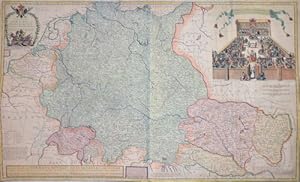
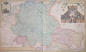
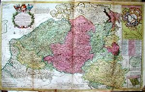
A new map of Germany. Hungary. Transivania and the Suisse Cantons.
Editore: Artist: Moll Hermann ( - 1732 ) London ; issued in: London ; dated: 1712; - Hermann Moll (1654- 1732) London was a cartographer engraver and publisher Moll produced his earliest maps from studying cartographers such as John Senex and Emanuel Bowen_ In the 1690s Moll worked mainly as an engraver for Christopher Browne Robert Morden and Lea in whose business he was also involved During this time he also published his first major independent work the Thesaurus Geographicus The success of this work likely influenced his decision to start publishing his own maps For the production of his maps Moll relied on the most accurate geographical information possible from first hand Moll benefited from his acquaintance with circumnavigator and privateer, 1654
Da: Antique Sommer& Sapunaru KG, München, Germania
Membro dell'associazione: ILAB VDA
Valutazione venditore:
Technic: Copper print; colorit: original colored; condition: Some folds partly restored, size (in cm): 60,5 x 99 cm; - Map shows total Germany with Hungary, Transilvania, Slavonia and Suisse, representation of a court of law.
-
A new map of Germany. Hungary. Transivania and the Suisse Cantons.
Editore: Artist: Moll Hermann ( - 1732 ) London ; issued in: London ; ca: 1712; - Hermann Moll (1654- 1732) London was a cartographer engraver and publisher Moll produced his earliest maps from studying cartographers such as John Senex and Emanuel Bowen_ In the 1690s Moll worked mainly as an engraver for Christopher Browne Robert Morden and Lea in whose business he was also involved During this time he also published his first major independent work the Thesaurus Geographicus The success of this work likely influenced his decision to start publishing his own maps For the production of his maps Moll relied on the most accurate geographical information possible from first hand Moll benefited from his acquaintance with circumnavigator and privateer Wil, 1654
Da: Antique Sommer& Sapunaru KG, München, Germania
Membro dell'associazione: ILAB VDA
Valutazione venditore:
Technic: Copper print; colorit: original colored; condition: Some folds partly restored, size (in cm): 60,50 x 99 cm; - Map shows total Germany with Hungary, Transilvania, Slavonia and Suisse, representation of a court of law.
-
Les Provinces des Pays-Bas Catholiques ou , a most exaxt map of Flanders.
Editore: Artist: Moll Hermann ( - 1732 ) London ; issued in: London ; ca: 1712; - Hermann Moll (1654- 1732) London was a cartographer engraver and publisher Moll produced his earliest maps from studying cartographers such as John Senex and Emanuel Bowen_ In the 1690s Moll worked mainly as an engraver for Christopher Browne Robert Morden and Lea in whose business he was also involved During this time he also published his first major independent work the Thesaurus Geographicus The success of this work likely influenced his decision to start publishing his own maps For the production of his maps Moll relied on the most accurate geographical information possible from first hand Moll benefited from his acquaintance with circumnavigator and privateer Wil, 1654
Da: Antique Sommer& Sapunaru KG, München, Germania
Membro dell'associazione: ILAB VDA
Valutazione venditore:
Technic: Copper print; colorit: original colored; condition: Some folds partly restored, size (in cm): 61 x 100; - Map of the Netherlands; - Special feature: Decorative map with minor Maps of Luxembourg, France and a fortification plan.
-
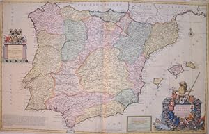
A new and exact map of Spain & Portugal
Editore: Artist: Moll Hermann ( - 1732 ) London ; issued in: London ; dated: 1711; - Hermann Moll (1654- 1732) London was a cartographer engraver and publisher Moll produced his earliest maps from studying cartographers such as John Senex and Emanuel Bowen_ In the 1690s Moll worked mainly as an engraver for Christopher Browne Robert Morden and Lea in whose business he was also involved During this time he also published his first major independent work the Thesaurus Geographicus The success of this work likely influenced his decision to start publishing his own maps For the production of his maps Moll relied on the most accurate geographical information possible from first hand Moll benefited from his acquaintance with circumnavigator and privateer, 1654
Da: Antique Sommer& Sapunaru KG, München, Germania
Membro dell'associazione: ILAB VDA
Valutazione venditore:
Technic: Copper print; colorit: original colored; condition: Centerfold and tears perfetly restored, size (in cm): 61 x 98 cm; - Map shows the Iberian Peninsula with Spain, Portugal and the Balearic Islands. On the lower right a magnificent title cartouche with 16 coats of arms of the different provinces of Spain as well as Portugal. Above the coats of arms is the Spanish lion. Together with the bull it is a symbol of the Iberian country. Left side a cartouche - To His Grace John Duke of Argile & c. General of Her Majesty's Armed Forces in Spain - above a representation of the coat of arms held by two lions.; - Special feature: Map printed on two plates, joined together.
-
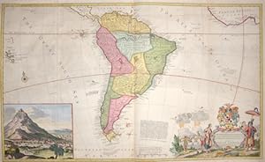
Map of South America
Editore: Artist: Moll Hermann ( - 1732 ) London ; issued in: London ; ca: 1710; - Hermann Moll (1654- 1732) London was a cartographer engraver and publisher Moll produced his earliest maps from studying cartographers such as John Senex and Emanuel Bowen_ In the 1690s Moll worked mainly as an engraver for Christopher Browne Robert Morden and Lea in whose business he was also involved During this time he also published his first major independent work the Thesaurus Geographicus The success of this work likely influenced his decision to start publishing his own maps For the production of his maps Moll relied on the most accurate geographical information possible from first hand Moll benefited from his acquaintance with circumnavigator and privateer Wil, 1654
Da: Antique Sommer& Sapunaru KG, München, Germania
Membro dell'associazione: ILAB VDA
Valutazione venditore:
Technic: Copper print; colorit: colored; condition: Very good, size (in cm): 58,5 x 98; - Map of South America with a decorative cartouche and a view of 'Potosi' (Peru).
-
To the Right Honorable Charles Earl of Perterborow, and Monmouth & this map of Africa
Editore: Artist: Moll Hermann ( - 1732 ) London ; issued in: London ; ca: 1714; - Hermann Moll (1654- 1732) London was a cartographer engraver and publisher Moll produced his earliest maps from studying cartographers such as John Senex and Emanuel Bowen_ In the 1690s Moll worked mainly as an engraver for Christopher Browne Robert Morden and Lea in whose business he was also involved During this time he also published his first major independent work the Thesaurus Geographicus The success of this work likely influenced his decision to start publishing his own maps For the production of his maps Moll relied on the most accurate geographical information possible from first hand Moll benefited from his acquaintance with circumnavigator and privateer Wil, 1654
Da: Antique Sommer& Sapunaru KG, München, Germania
Membro dell'associazione: ILAB VDA
Valutazione venditore:
Technic: Copper print; colorit: original colored; condition: Left and right upper corners perfectly replaced, size (in cm): 57 x 96; - Map shows total Afica with Madagascar and the maledives and 4 views of Good Hope, Fort of Good Hope, James Fort St. Helena, Cape coast castle in Guinea.; - Special feature: Map with beautiful cartouche, rare.
-
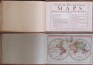
Twenty four New and Accurate Maps of the Parts of europe
Editore: Artist: Moll Hermann ( - 1732 ) London ; ca: 1720; - Hermann Moll (1654- 1732) London was a cartographer engraver and publisher Moll produced his earliest maps from studying cartographers such as John Senex and Emanuel Bowen_ In the 1690s Moll worked mainly as an engraver for Christopher Browne Robert Morden and Lea in whose business he was also involved During this time he also published his first major independent work the Thesaurus Geographicus The success of this work likely influenced his decision to start publishing his own maps For the production of his maps Moll relied on the most accurate geographical information possible from first hand Moll benefited from his acquaintance with circumnavigator and privateer William Dampier who ret, 1654
Da: Antique Sommer& Sapunaru KG, München, Germania
Membro dell'associazione: ILAB VDA
Valutazione venditore:
Libro
Technic: Copper print; colorit: colored; condition: , size (in cm): 21 x 32; - Pocket atlas with 22 maps of Europoe, 1 worl map. ( nr. 21, The swiss cantons, missing).
