
Importo totale (1 articolo articoli):
Destinazione ordine:

eastern hemisphere di map (41 risultati)
Vai alla pagina principale dei risultati di ricerca
Filtri di ricerca
Tipo di articolo
- Tutti i tipi di prodotto
- Libri (5)
- Riviste e Giornali (Nessun altro risultato corrispondente a questo perfezionamento)
- Fumetti (Nessun altro risultato corrispondente a questo perfezionamento)
- Spartiti (Nessun altro risultato corrispondente a questo perfezionamento)
- Arte, Stampe e Poster (26)
- Fotografie (Nessun altro risultato corrispondente a questo perfezionamento)
- Mappe (10)
- Manoscritti e Collezionismo cartaceo (Nessun altro risultato corrispondente a questo perfezionamento)
Condizioni Maggiori informazioni
- Nuovo (Nessun altro risultato corrispondente a questo perfezionamento)
- Come nuovo, Ottimo o Quasi ottimo (Nessun altro risultato corrispondente a questo perfezionamento)
- Molto buono o Buono (30)
- Discreto o Mediocre (Nessun altro risultato corrispondente a questo perfezionamento)
- Come descritto (11)
Legatura
- Tutte
- Rilegato (Nessun altro risultato corrispondente a questo perfezionamento)
- Brossura (26)
Ulteriori caratteristiche
- Prima ed. (29)
- Copia autograf. (Nessun altro risultato corrispondente a questo perfezionamento)
- Sovracoperta (Nessun altro risultato corrispondente a questo perfezionamento)
- Con foto (36)
- Non Print on Demand (41)
Lingua (2)
Spedizione gratuita
- Spedizione gratuita in U.S.A. (Nessun altro risultato corrispondente a questo perfezionamento)
Paese del venditore
Valutazione venditore
-

HEMISPHERE MAP, DOUBLE HEMISHERE MAP OF THE WORLD SHOWING THE WESTERN AND EASTERN HEMISPHERES, CIRCA 1840
Lingua: Inglese
Editore: H.G. COLLINS, London, 1840
Da: K Books Ltd ABA ILAB, York, YORKS, Regno Unito
Membro dell'associazione: ABA ILAB PBFA
Valutazione del venditore 5 su 5 stelle

Prima edizione
EUR 47,54
Spedizione EUR 22,55
Spedito da Regno Unito a U.S.A.Quantit�: 1 disponibili
Aggiungi al carrelloSingle Sheet. Condizione: Very Good. No Jacket. First Edition. HEMISPHERE MAP, DOUBLE HEMISPHERE MAP OF THE WORLD SHOWING THE WESTERN AND EASTERN HEMISPHERES, CIRCA 1840 MEASURES 23 X 11 INCHES, DISPATCHED IN A STRONG TUBE, WELL PACKED, REASONABLY PRICED .
-
Map Of the Eastern Hemisphere - Spherical Map - Fine Detailed Map - an Original Engraving
Lingua: Inglese
Data di pubblicazione: 1860
Da: K Books Ltd ABA ILAB, York, YORKS, Regno Unito
Membro dell'associazione: ABA ILAB PBFA
Valutazione del venditore 5 su 5 stelle
EUR 53,61
Spedizione EUR 22,55
Spedito da Regno Unito a U.S.A.Quantit�: 1 disponibili
Aggiungi al carrelloNo Binding. Condizione: Very Good. A fine engraving - printed circa 1860. Mounted and ready to frame. Hand colouring not contemporary, but delicately and expertly executed. A fine opportunity to purchase an attractive and decorative engraving - Map Of the Eastern Hemisphere - Spherical Map.
-
Eastern Hemisphere - an Antique Map
Lingua: Inglese
Da: K Books Ltd ABA ILAB, York, YORKS, Regno Unito
Membro dell'associazione: ABA ILAB PBFA
Valutazione del venditore 5 su 5 stelle
EUR 59,56
Spedizione EUR 22,55
Spedito da Regno Unito a U.S.A.Quantit�: 1 disponibili
Aggiungi al carrelloNo Binding. Condizione: Very Good. Engraved By Walker (illustratore). A fine antique map - printed in 1844. Mounted (matted) and ready to frame. Engraved size approx 16 x 13 Ins, 41 x 33 Cms. Mounted size approx 19 x 16 in, 49 x 41cm. Coloured in outline, hand colouring contemporary. A fine opportunity to purchase an attractive and decorative engraved antique map of the Eastern Hemisphere.
-

MAP: " Euroope".from Bradley's Atlas of the Eastern Hemisphere
Editore: Wm. M. Bradley & Co., Philadelphia, 1887
Da: Dorley House Books, Inc., Hagerstown, MD, U.S.A.
Valutazione del venditore 4 su 5 stelle

Arte / Stampa / Poster Prima edizione
Unbound. Condizione: Very Good. Handcolored Map (illustratore). 1st. Antique 27" x 18.75" hand colored map of Europe in 1887 Size: 27" x 18.75".
-

MAP: "The World in Hemispheres".from Bradley's Atlas of the Eastern Hemisphere
Editore: Wm. M. Bradley & Co., Philadelphia, 1887
Da: Dorley House Books, Inc., Hagerstown, MD, U.S.A.
Valutazione del venditore 4 su 5 stelle
Arte / Stampa / Poster Prima edizione
Unbound. Condizione: Very Good. Handcolored Map (illustratore). 1st. Antique hand colored map of the World featuring both Western & Eastern Hemispheres; lite marginal toning Size: 27" x 18.75".
-

MAP: "Chart of the World on Mercators Projection".from Bradley's Atlas of the Eastern Hemisphere
Editore: Wm. M. Bradley & Co., Philadelphia, 1887
Da: Dorley House Books, Inc., Hagerstown, MD, U.S.A.
Valutazione del venditore 4 su 5 stelle
Arte / Stampa / Poster Prima edizione
Unbound. Condizione: Very Good. Handcolored Map (illustratore). 1st. Antique hand colored map Chart of the World on Mercator's Projection showing of the Ocean Currents with the routes and distances between Principal Ports as they were in 1887; lite marginal toning Size: 27" x 18.75".
-
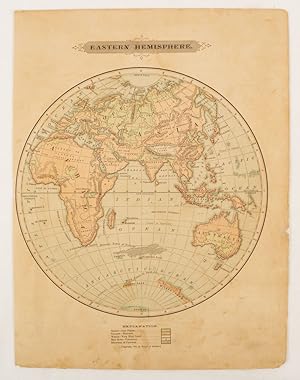
Eastern Hemisphere.
Editore: Harper & Brothers., 1875
Da: Asia Bookroom ANZAAB/ILAB, Canberra, ACT, Australia
Membro dell'associazione: ANZAAB ILAB
Valutazione del venditore 5 su 5 stelle
EUR 47,17
Spedizione EUR 26,02
Spedito da Australia a U.S.A.Quantit�: 1 disponibili
Aggiungi al carrelloSpherical map printed in colour, 21.3 x 21.2 cm with shaded key to elevation and ocean currents, unrelated text on the verso, paper toned and margins soiled, bottom edge ragged, small sealed to to the inner margin, but in sound condition. Map showing the five continents of Asia, Africa, Antarctica, Europe, and Australia. Published by Harper & Brothers for inclusion in their "School Geography". Plateau of Tibet very prominently marked. Gobi Desert and Plateau of Mongolia also marked, India described as Hindostan, Indo-China includes Thailand.
-

MAP: "Turkey in Asia; Asia Minor, & Persia & Afghanistan".from Bradley's Atlas of the Eastern Hemisphere
Editore: Wm. M. Bradley & Co., Philadelphia, 1887
Da: Dorley House Books, Inc., Hagerstown, MD, U.S.A.
Valutazione del venditore 4 su 5 stelle
Arte / Stampa / Poster Prima edizione
Unbound. Condizione: Very Good. Handcolored Map (illustratore). 1st. Antique 27" x 18.75" hand colored map of "Turkey in Asia; Asia Minor, & Persia & Afghanistan, " in 1887 Size: 27" x 18.75".
-

MAP: "European Russia".from Bradley's Atlas of the Eastern Hemisphere
Editore: Wm. M. Bradley & Co., Philadelphia, 1887
Da: Dorley House Books, Inc., Hagerstown, MD, U.S.A.
Valutazione del venditore 4 su 5 stelle
Arte / Stampa / Poster Prima edizione
Unbound. Condizione: Very Good. Handcolored Map (illustratore). 1st. Antique 27" x 18.75" hand colored map of "European Russia"., in 1887, including a full index of places Size: 27" x 18.75".
-

MAP: "Norway & Sweden: Scandinavia".from Bradley's Atlas of the Eastern Hemisphere
Editore: Wm. M. Bradley & Co., Philadelphia, 1887
Da: Dorley House Books, Inc., Hagerstown, MD, U.S.A.
Valutazione del venditore 4 su 5 stelle
Arte / Stampa / Poster Prima edizione
Unbound. Condizione: Very Good. Handcolored Map (illustratore). 1st. Antique 27" x 18.75" hand colored map of "Norway & Sweden: Scandinavia", in 1887, including a full index of places Size: 27" x 18.75".
-

MAP: "Belgium and the Netherlands; & Denmak".from Bradley's Atlas of the Eastern Hemisphere
Editore: Wm. M. Bradley & Co., Philadelphia, 1887
Da: Dorley House Books, Inc., Hagerstown, MD, U.S.A.
Valutazione del venditore 4 su 5 stelle
Arte / Stampa / Poster Prima edizione
Unbound. Condizione: Very Good. Handcolored Map (illustratore). 1st. Antique 27" x 18.75" hand colored map of Belgium and the Netherlands; & Denmak, in 1887, including a full index of places Size: 27" x 18.75".
-

MAP: "Africa".from Bradley's Atlas of the Eastern Hemisphere
Editore: Wm. M. Bradley & Co., Philadelphia, 1887
Da: Dorley House Books, Inc., Hagerstown, MD, U.S.A.
Valutazione del venditore 4 su 5 stelle
Arte / Stampa / Poster Prima edizione
Unbound. Condizione: Very Good. Handcolored Map (illustratore). 1st. Antique 27" x 18.75" hand colored map of "Africa". in 1887 including full index of places Size: 27" x 18.75".
-

MAP: "Turkey in Euruope, & Greece".from Bradley's Atlas of the Eastern Hemisphere
Editore: Wm. M. Bradley & Co., Philadelphia, 1887
Da: Dorley House Books, Inc., Hagerstown, MD, U.S.A.
Valutazione del venditore 4 su 5 stelle
Arte / Stampa / Poster Prima edizione
Unbound. Condizione: Very Good. Handcolored Map (illustratore). 1st. Antique 27" x 18.75" hand colored map of "Turkey in Euruope, & Greece" in 1887 Size: 27" x 18.75".
-

MAP: "Palestine".from Bradley's Atlas of the Eastern Hemisphere
Editore: Wm. M. Bradley & Co., Philadelphia, 1887
Da: Dorley House Books, Inc., Hagerstown, MD, U.S.A.
Valutazione del venditore 4 su 5 stelle
Arte / Stampa / Poster Prima edizione
Unbound. Condizione: Very Good. Handcolored Map (illustratore). 1st. Antique 27" x 18.75" hand colored map of "Palestine:" in 1887 including full index of places Size: 27" x 18.75".
-

MAP: "China & Japan".from Bradley's Atlas of the Eastern Hemisphere
Editore: Wm. M. Bradley & Co., Philadelphia, 1887
Da: Dorley House Books, Inc., Hagerstown, MD, U.S.A.
Valutazione del venditore 4 su 5 stelle
Arte / Stampa / Poster Prima edizione
Unbound. Condizione: Very Good. Handcolored Map (illustratore). 1st. Antique 27" x 18.75" hand colored map of "China & Japan". in 1887 including full index of places Size: 27" x 18.75".
-

MAP: "Asia".from Bradley's Atlas of the Eastern Hemisphere
Editore: Wm. M. Bradley & Co., Philadelphia, 1887
Da: Dorley House Books, Inc., Hagerstown, MD, U.S.A.
Valutazione del venditore 4 su 5 stelle
Arte / Stampa / Poster Prima edizione
Unbound. Condizione: Very Good. Handcolored Map (illustratore). 1st. Antique 27" x 18.75" hand colored map of "Asia" in 1887 Size: 27" x 18.75".
-

MAP: "India".from Bradley's Atlas of the Eastern Hemisphere
Editore: Wm. M. Bradley & Co., Philadelphia, 1887
Da: Dorley House Books, Inc., Hagerstown, MD, U.S.A.
Valutazione del venditore 4 su 5 stelle
Arte / Stampa / Poster Prima edizione
Unbound. Condizione: Very Good. Handcolored Map (illustratore). 1st. Antique 27" x 18.75" hand colored map of "India". in 1887 including full index of places Size: 27" x 18.75".
-

MAP: "Australia & New Zealand.".from Bradley's Atlas of the Eastern Hemisphere
Editore: Wm. M. Bradley & Co., Philadelphia, 1887
Da: Dorley House Books, Inc., Hagerstown, MD, U.S.A.
Valutazione del venditore 4 su 5 stelle
Arte / Stampa / Poster Prima edizione
Unbound. Condizione: Very Good. Handcolored Map (illustratore). 1st. Antique 27" x 18.75" hand colored map of "Australia & New Zealand." in 1887 Size: 27" x 18.75".
-

MAP: "Empire of Germany: Southern Portion".from Bradley's Atlas of the Eastern Hemisphere
Editore: Wm. M. Bradley & Co., Philadelphia, 1887
Da: Dorley House Books, Inc., Hagerstown, MD, U.S.A.
Valutazione del venditore 4 su 5 stelle
Arte / Stampa / Poster Prima edizione
Unbound. Condizione: Very Good. Handcolored Map (illustratore). 1st. Antique 27" x 18.75" hand colored map of "Empire of Germany: Southern Portion", in 1887, including a full index of places Size: 27" x 18.75".
-

MAP: "Austro-Hungarian Monnarchy".from Bradley's Atlas of the Eastern Hemisphere
Editore: Wm. M. Bradley & Co., Philadelphia, 1887
Da: Dorley House Books, Inc., Hagerstown, MD, U.S.A.
Valutazione del venditore 4 su 5 stelle
Arte / Stampa / Poster Prima edizione
Unbound. Condizione: Very Good. Handcolored Map (illustratore). 1st. Antique 27" x 18.75" hand colored map of The Austro-Hungarian Monarchy, in 1887 Size: 27" x 18.75".
-

MAP: "Empire of Germany: Northern Portion".from Bradley's Atlas of the Eastern Hemisphere
Editore: Wm. M. Bradley & Co., Philadelphia, 1887
Da: Dorley House Books, Inc., Hagerstown, MD, U.S.A.
Valutazione del venditore 4 su 5 stelle
Arte / Stampa / Poster Prima edizione
Unbound. Condizione: Very Good. Handcolored Map (illustratore). 1st. Antique 27" x 18.75" hand colored map of "Empire of Germany: Northern Portion", in 1887, including a full index of places Size: 27" x 18.75".
-

MAP: "Switzerland".from Bradley's Atlas of the Eastern Hemisphere
Editore: Wm. M. Bradley & Co., Philadelphia, 1887
Da: Dorley House Books, Inc., Hagerstown, MD, U.S.A.
Valutazione del venditore 4 su 5 stelle
Arte / Stampa / Poster Prima edizione
Unbound. Condizione: Very Good. Handcolored Map (illustratore). 1st. Antique 27" x 18.75" hand colored map of Switzerland in 1887.with full page index to places included Size: 27" x 18.75".
-

MAP: "Italy".from Bradley's Atlas of the Eastern Hemisphere
Editore: Wm. M. Bradley & Co., Philadelphia, 1887
Da: Dorley House Books, Inc., Hagerstown, MD, U.S.A.
Valutazione del venditore 4 su 5 stelle
Arte / Stampa / Poster Prima edizione
Unbound. Condizione: Very Good. Handcolored Map (illustratore). 1st. Antique 27" x 18.75" hand colored map of Italy in 1887 Size: 27" x 18.75".
-

MAP: "North Polar Chart".from Bradley's Atlas of the Eastern Hemisphere
Editore: Wm. M. Bradley & Co., Philadelphia, 1887
Da: Dorley House Books, Inc., Hagerstown, MD, U.S.A.
Valutazione del venditore 4 su 5 stelle
Arte / Stampa / Poster Prima edizione
Unbound. Condizione: Very Good. Handcolored Map (illustratore). 1st. Antique hand colored map of the North Pole featuring the most northern parts of North America, Europe, and Asia (including Greenland and Iceland). Size: 27" x 18.75".
-

MAP: " England & Wales".from Bradley's Atlas of the Eastern Hemisphere
Editore: Wm. M. Bradley & Co., Philadelphia, 1887
Da: Dorley House Books, Inc., Hagerstown, MD, U.S.A.
Valutazione del venditore 4 su 5 stelle
Arte / Stampa / Poster Prima edizione
Unbound. Condizione: Very Good. Handcolored Map (illustratore). 1st. Antique 27" x 18.75" hand colored map of England and Wales in 1887 , with the place index included Size: 27" x 18.75".
-

MAP: "France".from Bradley's Atlas of the Eastern Hemisphere
Editore: Wm. M. Bradley & Co., Philadelphia, 1887
Da: Dorley House Books, Inc., Hagerstown, MD, U.S.A.
Valutazione del venditore 4 su 5 stelle
Arte / Stampa / Poster Prima edizione
Unbound. Condizione: Very Good. Handcolored Map (illustratore). 1st. Antique 27" x 18.75" hand colored map of France in 1887, with place index included Size: 27" x 18.75".
-

MAP: "Ireland".from Bradley's Atlas of the Eastern Hemisphere
Editore: Wm. M. Bradley & Co., Philadelphia, 1887
Da: Dorley House Books, Inc., Hagerstown, MD, U.S.A.
Valutazione del venditore 4 su 5 stelle
Arte / Stampa / Poster Prima edizione
Unbound. Condizione: Very Good. Handcolored Map (illustratore). 1st. Antique 27" x 18.75" hand colored map of Ireland in 1887, with the place index included Size: 27" x 18.75".
-

MAP: "Scotland".from Bradley's Atlas of the Eastern Hemisphere
Editore: Wm. M. Bradley & Co., Philadelphia, 1887
Da: Dorley House Books, Inc., Hagerstown, MD, U.S.A.
Valutazione del venditore 4 su 5 stelle
Arte / Stampa / Poster Prima edizione
Unbound. Condizione: Very Good. Handcolored Map (illustratore). 1st. Antique 27" x 18.75" hand colored map of Scotland in 1887, with the place index included Size: 27" x 18.75".
-

MAP: "Spain & Portugal".from Bradley's Atlas of the Eastern Hemisphere
Editore: Wm. M. Bradley & Co., Philadelphia, 1887
Da: Dorley House Books, Inc., Hagerstown, MD, U.S.A.
Valutazione del venditore 4 su 5 stelle
Arte / Stampa / Poster Prima edizione
Unbound. Condizione: Very Good. Handcolored Map (illustratore). 1st. Antique 27" x 18.75" hand colored map of Spain & Portugal in 1887, with the place index included Size: 27" x 18.75".
-
MAP: "Western Hemisphere/ Eastern Hemisphere".from Johnson's New Illustrated (Steel Plate) Family Atlas, 1861
Editore: Johnson & Browning, Richmond, VA, 1861
Da: Dorley House Books, Inc., Hagerstown, MD, U.S.A.
Valutazione del venditore 4 su 5 stelle
Arte / Stampa / Poster Prima edizione
Unbound. Condizione: Very Good. Handcolored Map (illustratore). 1st. Plate #4,5: lovely double page map (lite toning) ; hemispheric projections of the world in the mid 19th century Size: 17 x 24.5 Inches.
