
Importo totale (1 articolo articoli):
Destinazione ordine:

kansas city di rand mcnally (44 risultati)
Vai alla pagina principale dei risultati di ricerca
Tipo di articolo
- Tutti gli articoli
- Libri (42)
- Riviste e Giornali
- Fumetti
- Spartiti
- Arte, Stampe e Poster
- Fotografie
- Mappe (2)
-
Manoscritti e
Collezionismo cartaceo
Condizioni
Legatura
- Tutte
- Rilegato
- Brossura (19)
Ulteriori caratteristiche
- Prima edizione (1)
- Copia autografata
- Sovraccoperta
- Con foto (15)
- No print on demand
Paese del venditore
Valutazione venditore
-

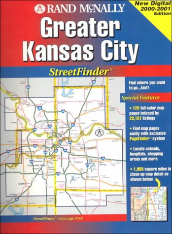
Rand McNally Kansas City: Streetfinder
Editore: Rand Mcnally
ISBN 10: 0528913662ISBN 13: 9780528913662
Libro
Condizione: Fair. [ No Hassle 30 Day Returns ][ Ships Daily ] [ Underlining/Highlighting: NONE ] [ Writing: NONE ] [ Edition: First ] Publisher: Rand Mcnally Pub Date: 6/1/1995 Binding: Paperback Pages: 143 First edition.
-

Rand McNally Folded Map Kansas City Street Map
Editore: 0, 2022
ISBN 10: 0528025007ISBN 13: 9780528025006
Libro
Condizione: New. Brand New! Not Overstocks or Low Quality Book Club Editions! Direct From the Publisher! We're not a giant, faceless warehouse organization! We're a small town bookstore that loves books and loves it's customers! Buy from Lakeside Books!.
Ulteriori offerte da altri venditori AbeBooks
Nuovo - A partire da EUR 6,90
Usato - A partire da EUR 57,14
Scopri anche Brossura
-
Kansas City (Kansas/Missouri) (USA StreetFinder Atlas S.)
Editore: Rand McNally & Co ,U.S., 2000
ISBN 10: 052899073XISBN 13: 9780528990731
Libro
Spiral Bound. Condizione: Very Good. Book.
-
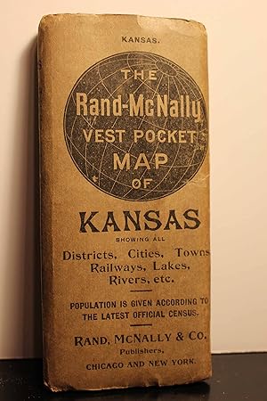
The Rand-Mcnally Vest Pocket Map of Kansas Showing all Counties, Cities, Towns, Railways, Lakes, Rivers, Etc
Editore: Rand McNally & Company ca 1913, 1913
Softcover. Condizione: Good+. Map is folded and cover has minor soiling. The only problem is that of having been folded for a long time, but pages are not brittle.
-
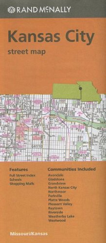
Rand McNally Kansas City Street Map
Editore: Rand McNally, 2013
ISBN 10: 0528008404ISBN 13: 9780528008405
Libro
Condizione: Good. Book is in Used-Good condition. Pages and cover are clean and intact. Used items may not include supplementary materials such as CDs or access codes. May show signs of minor shelf wear and contain limited notes and highlighting.
Ulteriori offerte da altri venditori AbeBooks
Nuovo - A partire da EUR 45,87
Usato - A partire da EUR 43,71
Scopri anche Brossura
-
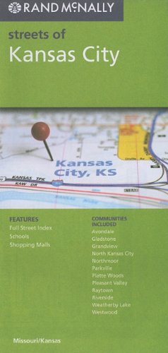
Rand McNally Streets of Kansas City, Missouri/Kansas
Editore: Rand McNally, 2010
ISBN 10: 0528879936ISBN 13: 9780528879937
Libro
map. Condizione: Good. This is a used book in good condition and may show some signs of use or wear . This is a used book in good condition and may show some signs of use or wear .
-
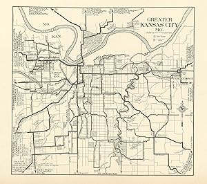
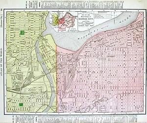
This map was produced by Rand McNally and Co. as part of its 1928 Commercial Atlas of America. These maps are some of our favorite maps because of the large size of each map sheet. The detail shown on each map is exceptional because of the map size. These maps were intended to be used by business for shipping and other uses. Roads, railroads, rivers, and buildings are clearly shown. There is more detail on these maps than any others during this time period. This map measures 6 inches by 6.5 inches.
-
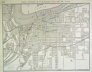
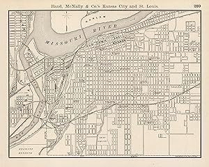
This map was produced by Rand McNally and Company for its "Business Atlas and Shippers Guide" in 1889. These highly detailed maps were acknowledged as the premier business shipping maps with much attention paid to even the smallest of villages. This map measures 12.5 inches by 9.5 inches.
-
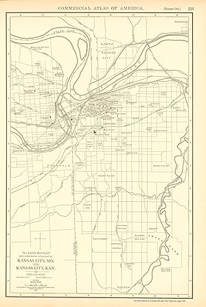
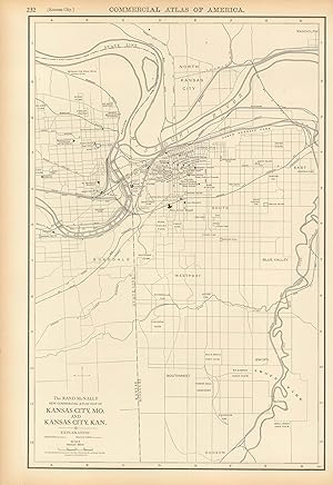
This map of Kansas City Mo. and Kansas City Kan. was produced by Rand McNally and Co. as part of its Commercial Atlas of America. These maps are some of our favorite maps because of the large size of each map. The detail shown on each map is exceptional because of the map size. These maps were intended to be used by business for shipping and other uses. Roads, railroads, rivers, and buildings are clearly shown. There is more detail on these maps than any others during this time period.The map measures 12.5 by 18 inches.
-
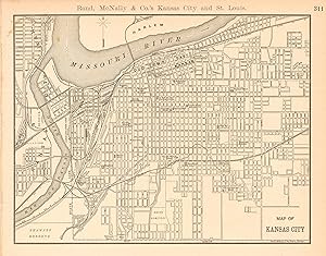
This map of Kansas City was issued by Rand McNally & Co. as part of the Business Atlas and Shippers Guide in 1890. The Rand McNally Company was the premiere mapmaker in the business and shipping map arena. This highly detailed map shows streets, points of interest, various geographic features, and highlights the expansive railroad system of the time with great accuracy. This map measures 11.75 inches by 9 inches.
-
This detailed map was originally published in Rand, McNally & Co.s Universal Atlas of The World. From its beginnings as a small Chicago printing shop in 1856, Rand McNally & Company launched a 146-year continuing journey that has led the company to its place as the world's premier provider of geographic and travel information. This colorful map was published at the turn of the century in 1902. This map shows cities and towns, lakes and rivers, and the existing railroad network. Also note the information in the margin of the state maps which details land and water area, population broken down by gender and ethnic group, and the population of major towns and counties. City maps show the location of major streets and roads, as well as points of interest. This map measures 11 inches by 13 inches.
-
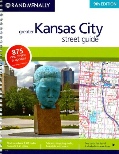
Rand McNally Greater Kansas City Street Guide (Rand McNally Kansas City Street Guide)
Editore: Rand McNally & Company, 2008
ISBN 10: 0528866826ISBN 13: 9780528866821
Da: Friends of Johnson County Library, Lenexa, KS, U.S.A.
Valutazione venditore:

Libro
Condizione: Good. Spiral bound book showing some wear. All items ship Monday - Saturday - Fast Shipping in a secure package. Your purchase will help support the programs and collections of the Johnson County (Kansas) Library.
Ulteriori offerte da altri venditori AbeBooks
Nuovo - A partire da EUR 335,47
Usato - A partire da EUR 71,39
Scopri anche Brossura
-
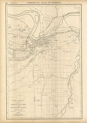
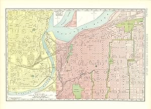
This map of Kansas City was produced by Rand McNally and Co. as part of its Commercial Atlas of America. The detail shown on each map is exceptional because of the map size. These maps were intended to be used by business for shipping, etc. Roads, railroads, and rivers are clearly shown. There is more detail on these maps than any others during this time period. This map measures 19 inches by 12.5 inches.
-
We are proud to offer this map of Kansas City, originally produced as part of Rand McNally's Enlarged Business Atlas dated 1891. Although the table of contents shows different editions starting in 1885, we believe this is the first edition of the Enlarged Atlas. Each of these maps accurately locates all cities, towns, post offices, railroad stations, villages, counties, parishes, islands, lakes, rivers, mountains and more. Until McNallyâ s enlarged Business Atlas, maps had never been produced that provided as much information as these do. Even today, we use these 130 year old maps to locate small towns, villages, and railroad routes that are no more. This map measures 13.25 inches by 10.5 inches.
-
We are proud to offer this wonderful large scale map originally issued as part of Rand McNally's Commercial Atlas of America in 1919. The maps from this atlas were larger than most atlas' published at the time and show many more cities and towns. All railroad lines were drawn in red and numbered with a listing of all railroads operating in the area on each map. William H. Rand founded the company in 1856 and incorporated it in 1873 with his partner Andrew McNally. They published their first atlas, The Business Atlas, in 1877. Rand McNally and Company is the oldest business of its kind in the country. This map measures 19 inches by 12.5 inches.
-
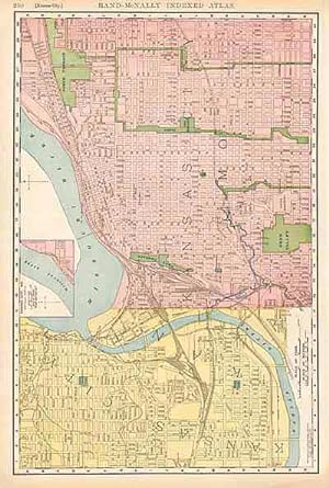
This large format map was published in Rand McNally & Co.s Indexed Atlas of the World, dated 1908. This detailed country map shows, cities and towns, counties, provinces or regions, lakes and rivers, and many other details. Unique to this map is the information provided on the existing railroad network at the time. Each railroad is shown, along with scheduled stops. Many maps also contain a listing of the railroads at the time. Map also provides capitals, scale of miles, and a detailed list of towns down the side noting population. A neat glimpse of the world in the early 20th century. This map measures 12.5 inches by 19 inches.
-
Kansas City Including Claycomo, Fairway, Gladstone, Grandview . and Neighboring Communities
Editore: Rand McNally & Co ,U. S., 1985
ISBN 10: 0528271210ISBN 13: 9780528271212
Mappa
Map. Condizione: Very Good-. Very slight water damage. - Great overall condition. Minor cosmetic wear. No major blemishes. No writing.
-
We are proud to offer this wonderful large scale map of Kansas City originally issued as part of Rand McNallyâ s Enlarged Business Atlas and Shippers Guide in 1907. The maps from this atlas were larger than most atlasâ published at the time and show many more cities and towns. All railroad lines were drawn in red and numbered with a listing of all railroads operating in the state on each map. Features a small inset of the Northeast portion--Kansas City, MO. William H. Rand founded the company in 1856 and incorporated it in 1873 with his partner Andrew McNally. They published their first atlas, The Business Atlas, in 1877. Rand McNally and Company is the oldest business of itâ s kind in the country. This map measures 12.5 inches by 19.5 inches.
-
We are proud to offer this wonderful large scale map originally issues as part of Rand, McNally's Enlarged Business Atlas and Shippers Guide, Showing in Detail the Entire Railroad System in 1902. The maps from this atlas were larger than most atlas' published at the time and show many more cities and towns. All railroad lines were drawn in red and numbered with a listing of all railroads operating in the state on each map. William H. Rand founded the company in 1856 and incorporated it in 1873 with his partner Andrew McNally. They published their first atlas, The Business Atlas, in 1877. Rand McNally and Company is the oldest business of its kind in the country.This map measures 12.25 inches by 19.5 inches.
-
This map is from the 1895 "Rand McNally & Co.s Enlarged Business Atlas and Shipper's Guide, containing large scale maps of all states and territories in the United States, the Dominion of Canada, the Republic of Mexico, Central America, the West Indies, and Cuba, showing in detail the entire railroad system, the different railroads being distinguished by different figures, accompanied by a new and original compilation and ready reference index, giving the express company doing business over each road, and accurately locating all islands, lakes, rivers, mountains, counties, parishes, cities, towns, post offices, railroad stations, villages, etc, together with complete reference maps of all countries, printed from type-lettered plates, producing the clearest typographical effect of any known engraved plates, also guide maps showing the streets, transportation lines, and public buildings of the large cities in the United States". This map measures 12.5 inches by 19 inches.