Importo totale (1 articolo articoli):
Destinazione ordine:

map ohio di colton j h (20 risultati)
Vai alla pagina principale dei risultati di ricerca
Tipo di articolo
- Tutti gli articoli
- Libri (18)
- Riviste e Giornali
- Fumetti
- Spartiti
- Arte, Stampe e Poster (1)
- Fotografie
- Mappe (1)
-
Manoscritti e
Collezionismo cartaceo
Condizioni
Legatura
Ulteriori caratteristiche
- Prima edizione (1)
- Copia autografata
- Sovraccoperta
- Con foto (15)
- No print on demand (16)
Spedizione gratuita
Paese del venditore
Valutazione venditore
-
![Immagine del venditore per The western tourist and emigrant's guide through the states of Ohio, Michigan, Indiana, Illinois, Missouri, Iowa, and Wisconsin, and the territories of Minnesota, Missouri, and Nebraska being an accurate and concise description of each state and territory; and containing the routes and distances on the great lines of travel. Accompanied with a large and minute map, exhibiting the township lines of the United States' surveys, the boundaries of counties, and the position of cities, villages and settlements, etc., etc (1855) [Leatherbound] venduto da S N Books World](https://pictures.abebooks.com/inventory/md/md30639876964.jpg)
The western tourist and emigrant's guide through the states of Ohio, Michigan, Indiana, Illinois, Missouri, Iowa, and Wisconsin, and the territories of Minnesota, Missouri, and Nebraska being an accurate and concise description of each state and territory; and containing the routes and distances on the great lines of travel. Accompanied with a large and minute map, exhibiting the township lines of the United States' surveys, the boundaries of counties, and the position of cities, villages and settlements, etc., etc (1855) [Leatherbound]
Data di pubblicazione: 2022
Libro Print on Demand
Leatherbound. Condizione: NEW. Leatherbound edition. Condition: New. Leather Binding on Spine and Corners with Golden leaf printing on spine. Bound in genuine leather with Satin ribbon page markers and Spine with raised gilt bands. A perfect gift for your loved ones. Reprinted from 1855 edition. NO changes have been made to the original text. This is NOT a retyped or an ocr'd reprint. Illustrations, Index, if any, are included in black and white. Each page is checked manually before printing. As this print on demand book is reprinted from a very old book, there could be some missing or flawed pages, but we always try to make the book as complete as possible. Fold-outs, if any, are not part of the book. If the original book was published in multiple volumes then this reprint is of only one volume, not the whole set. IF YOU WISH TO ORDER PARTICULAR VOLUME OR ALL THE VOLUMES YOU CAN CONTACT US. Resized as per current standards. Sewing binding for longer life, where the book block is actually sewn (smythe sewn/section sewn) with thread before binding which results in a more durable type of binding. Pages: 126 Language: English Pages: 126.
-
![Immagine del venditore per The western tourist; or, Emigrant's guide through the states of Ohio, Michigan, Indiana, Illinois, and Missouri, and the territories of Wisconsin and Iowa: being an accurate and concise description of each state, territory, and county. Also, describing all the principal stage routes, canals, railroads, and the distances between the towns. Accompanied with a correct map, showing the township lines of the United States' surveys, the boundaries of counties, position of villages, etc. (1846) [Leatherbound] venduto da S N Books World](https://pictures.abebooks.com/inventory/md/md30877197952.jpg)
The western tourist; or, Emigrant's guide through the states of Ohio, Michigan, Indiana, Illinois, and Missouri, and the territories of Wisconsin and Iowa: being an accurate and concise description of each state, territory, and county. Also, describing all the principal stage routes, canals, railroads, and the distances between the towns. Accompanied with a correct map, showing the township lines of the United States' surveys, the boundaries of counties, position of villages, etc. (1846) [Leatherbound]
Data di pubblicazione: 2022
Libro Print on Demand
LeatherBound. Condizione: NEW. Leatherbound edition. Condition: New. Leather Binding on Spine and Corners with Golden leaf printing on spine. Bound in genuine leather with Satin ribbon page markers and Spine with raised gilt bands. A perfect gift for your loved ones. Reprinted from 1846 edition. NO changes have been made to the original text. This is NOT a retyped or an ocr'd reprint. Illustrations, Index, if any, are included in black and white. Each page is checked manually before printing. As this print on demand book is reprinted from a very old book, there could be some missing or flawed pages, but we always try to make the book as complete as possible. Fold-outs, if any, are not part of the book. If the original book was published in multiple volumes then this reprint is of only one volume, not the whole set. IF YOU WISH TO ORDER PARTICULAR VOLUME OR ALL THE VOLUMES YOU CAN CONTACT US. Resized as per current standards. Sewing binding for longer life, where the book block is actually sewn (smythe sewn/section sewn) with thread before binding which results in a more durable type of binding. Pages: 130 Language: English Pages: 130.
-
![Immagine del venditore per The western tourist and emigrant's guide : through the states of Ohio, Michigan, Indiana, Illinois, Missouri, Iowa, and Wisconsin, and the territories of Minesota, Missouri, and Nebraska. Being an accurate and concise description of each state and territory; and containing the routes and distances on the great lines of travel. Accompanied with a large and minute map, exhibiting the township lines of the United States' surveys, the boundaries of counties, and the position of cities, villages and settlements, etc., etc (1854) [Leatherbound] venduto da S N Books World](https://pictures.abebooks.com/inventory/md/md30639875350.jpg)
The western tourist and emigrant's guide : through the states of Ohio, Michigan, Indiana, Illinois, Missouri, Iowa, and Wisconsin, and the territories of Minesota, Missouri, and Nebraska. Being an accurate and concise description of each state and territory; and containing the routes and distances on the great lines of travel. Accompanied with a large and minute map, exhibiting the township lines of the United States' surveys, the boundaries of counties, and the position of cities, villages and settlements, etc., etc (1854) [Leatherbound]
Data di pubblicazione: 2022
Libro Print on Demand
Leatherbound. Condizione: NEW. Leatherbound edition. Condition: New. Leather Binding on Spine and Corners with Golden leaf printing on spine. Bound in genuine leather with Satin ribbon page markers and Spine with raised gilt bands. A perfect gift for your loved ones. Reprinted from 1854 edition. NO changes have been made to the original text. This is NOT a retyped or an ocr'd reprint. Illustrations, Index, if any, are included in black and white. Each page is checked manually before printing. As this print on demand book is reprinted from a very old book, there could be some missing or flawed pages, but we always try to make the book as complete as possible. Fold-outs, if any, are not part of the book. If the original book was published in multiple volumes then this reprint is of only one volume, not the whole set. IF YOU WISH TO ORDER PARTICULAR VOLUME OR ALL THE VOLUMES YOU CAN CONTACT US. Resized as per current standards. Sewing binding for longer life, where the book block is actually sewn (smythe sewn/section sewn) with thread before binding which results in a more durable type of binding. Pages: 134 Language: English Pages: 134.
-
![Immagine del venditore per The western tourist : or, Emigrant's guide through the states of Ohio, Michigan, Indiana, Illinois, and Missouri, and the territories of Wisconsin and Iowa: being an accurate and concise description of each state, territory, and county / Also, describing all the principal stage routes, canals, railroads, and the distances between the towns. Accompanied with a correct map, showing the township lines of the United States' surveys, the boundaries of counties, position of villages, etc. (1839) [Leatherbound] venduto da S N Books World](https://pictures.abebooks.com/inventory/md/md30877367759.jpg)
The western tourist : or, Emigrant's guide through the states of Ohio, Michigan, Indiana, Illinois, and Missouri, and the territories of Wisconsin and Iowa: being an accurate and concise description of each state, territory, and county / Also, describing all the principal stage routes, canals, railroads, and the distances between the towns. Accompanied with a correct map, showing the township lines of the United States' surveys, the boundaries of counties, position of villages, etc. (1839) [Leatherbound]
Data di pubblicazione: 2022
Libro Print on Demand
LeatherBound. Condizione: NEW. Leatherbound edition. Condition: New. Leather Binding on Spine and Corners with Golden leaf printing on spine. Bound in genuine leather with Satin ribbon page markers and Spine with raised gilt bands. A perfect gift for your loved ones. Reprinted from 1839 edition. NO changes have been made to the original text. This is NOT a retyped or an ocr'd reprint. Illustrations, Index, if any, are included in black and white. Each page is checked manually before printing. As this print on demand book is reprinted from a very old book, there could be some missing or flawed pages, but we always try to make the book as complete as possible. Fold-outs, if any, are not part of the book. If the original book was published in multiple volumes then this reprint is of only one volume, not the whole set. IF YOU WISH TO ORDER PARTICULAR VOLUME OR ALL THE VOLUMES YOU CAN CONTACT US. Resized as per current standards. Sewing binding for longer life, where the book block is actually sewn (smythe sewn/section sewn) with thread before binding which results in a more durable type of binding. Pages: 194 Language: English Pages: 194.
-
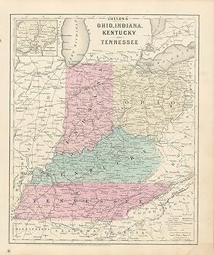
Colton's 1860 Map of Ohio, Indiana, Kentucky, and Tennessee with inset map of Cincinnati
Data di pubblicazione: 1860
This political map was issued as part of J.H. Coltons's 1860 School Atlas. We consider Colton to be the premier mapmaker in American history. His maps are known for their precision and attention to detail. This map measures 12 inches by 9.75 inches.
-

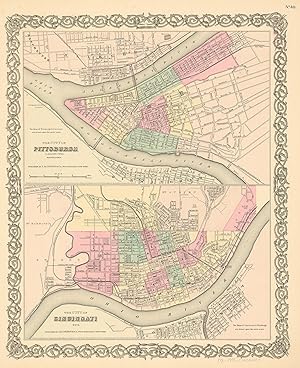
MAP OF THE CITIES OF PITTSBURGH AND ALLEGHENY, PENNSYLVANIA & THE CITY OF CINCINNATI, OHIO [From Colton's Atlas of the World Illustrating Physical and Political Geography Volume I]
Editore: Colton, 1856
Pamphlet. Condizione: Good. Map is 18.5 x 16 inches, Elaborate border, Hand-WaterColored in Pastels, slight moist darkening at lower right just touching elaborate border, else VG & Attractive & Could be Beautifully Framed (Map is dated 1855) (Inset Map at bottom shows Cleveland).
-
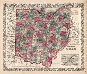
MAP OF OHIO [From Colton's Atlas of the World Illustrating Physical and Political Geography Volume I]
Editore: Colton, 1856
Pamphlet. Condizione: Good. Map is 18.5 x 16 inches, Elaborate border, Hand WaterColored in Pastels, light brn moist darkening at lower left corner stretching to upper center, just barely noticeable. Map is still very Attractive & Could be Beautifully Framed (Map is dated 1855) (Inset Map at bottom shows Cleveland).
-
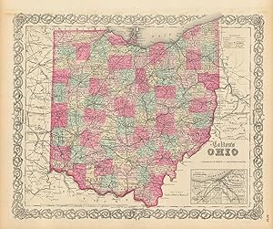
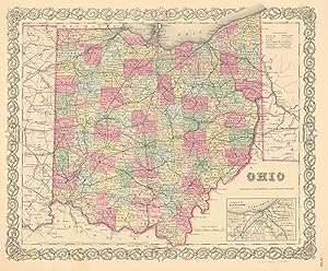
Colton's Map of Ohio
Editore: J.H. Colton & Co., New York, 1857
Da: Nicholas D. Riccio Rare Books, ABAA, Florham Park, NJ, U.S.A.
Membro dell'associazione: ABAA ILAB
Valutazione venditore:

New York: G.W. & C.B. Colton & Co., 1866. Unbound, colored engraved map, decorative boarder, 16"x 13". Slight toning and aging; overall bright and clean and in very good condition. Maps are wrapped with acid free board, or in rigid sleeves. Beginning with J. H. Colton (1800-1893), the Colton family published atlases for over 30 years. Colton's Atlas of the World was first published in 1855 in a large two volume set. In 1857 it became Colton's General Atlas, and Colton's sons, George Woolworth and Charles B. would take over the business. This map of Ohio is from the rather scarce 1857 edition of Colton's General Atlas. The map has decent color with a fair amount of detail, and includes a small inset map of Cleveland. May require extra postage.Ristow 313-326.
-
We are pleased to offer this map issued as part of Colton's General Atlas, published in 1865. The Civil War ended April 9, 1865 and this atlas was one of the first post-Civil War atlas' published. Colton continued his tradition of beautiful hand coloring with this atlas. This map measures 13 inches by 16 inches.
-
J.H. Colton's 1855 Map of The City of Pittsburgh, Pennsylvania and The City of Cincinnati, Ohio
Data di pubblicazione: 1855
Joseph Hutchins Colton (1800-1893) started one of the premier map publishing firms in the U.S. His first printed map dated 1833, was a reprint of David Burrs map of the state of New York. The Colton firm was one of the primary publishers of guidebooks, immigrant maps, and railroad maps. In 1855 Colton issued his first atlas, "Colton's Atlas of the World." They refused to compromise quality, choosing to compete for sales in the finer quality international market rather than the inexpensive domestic one. Because of this, all maps were engraved by steel plates rather than by wax engraving which was the most common method used at this time. This map is very detailed with identification of provinces and or regions, cities, towns and villages, transportation routes including rail roads, common roads, and canals, rivers and lakes, battle fields, and mountain ranges. Each map has beautiful muted red, green, tan, pink, and yellow hand coloring. Art Source International is proud and excited to offer maps from this very rare atlas. We have been in the antique map business for over forty years and these are the true first edition maps (1855) we have ever offered. Don't wait too long to purchase this piece of American mapping history! This map measures 16 inches by 13 inches.
-
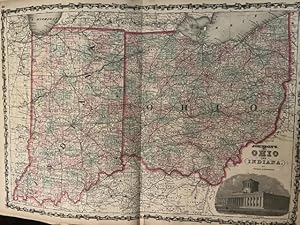
MAP: "Johnson's Ohio & Indiana (1861)'.from Johnson's New Illustrated (Steel Plate) Family Atlas, 1861
Editore: Johnson & Browning, Richmond, VA, 1861
Arte / Stampa / Poster Prima edizione
Unbound. Condizione: Very Good. Handcolored Map (illustratore). 1st. Plate #43,44; lovely double page hand-colored map; of Ohio & Indiana at the beginning of the Civil War, decorative strapwork border; w/ Counties, cities, roads, rivers, railroads, wagon roads,canals, ports, etc. & w/inset engravings; seam reinforced Size: 17 x 24.5 Inches.
-
Art Source International is proud to offer this map of Ohio (with an inset map of the Vicinity of Cleveland, Cuyahoga Co.) from the 1866 edition of Coltons General Atlas. Colton atlases, especially those from the late 1860's, have become increasingly difficult to find. This highly detailed map is distinguished by its hand coloring and signature 3/4" border. Counties, cities and towns, railroads, and various geographic features are shown on this map. This map measures 13.25 inches by 15.75 inches.
-
Joseph Hutchins Colton (1800-1893) started one of the premier map publishing firms in the U.S. His first printed map dated 1833, was a reprint of David Burrs map of the state of New York. The Colton firm was one of the primary publishers of guidebooks, immigrant maps, and railroad maps. In 1855 Colton issued his first atlas, "Colton's Atlas of the World." They refused to compromise quality, choosing to compete for sales in the finer quality international market rather than the inexpensive domestic one. Because of this, all maps were engraved by steel plates rather than by wax engraving which was the most common method used at this time. This map is very detailed with identification of provinces and or regions, cities, towns and villages, transportation routes including rail roads, common roads, and canals, rivers and lakes, battle fields, and mountain ranges. Each map has beautiful muted red, green, tan, pink, and yellow hand coloring. Art Source International is proud and excited to offer maps from this very rare atlas. We have been in the antique map business for over forty years and these are the true first edition maps (1855) we have ever offered. Don't wait too long to purchase this piece of American mapping history! This map measures 13.5 inches by 16 inches.
-
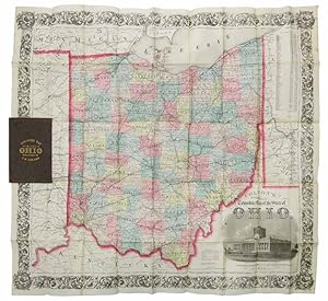
COLTON'S RAILROAD & TOWNSHIP MAP Of The STATE Of OHIO
Editore: J. H. Colton, New York, 1856
Da: Tavistock Books, ABAA, Reno, NV, U.S.A.
Membro dell'associazione: ABAA ESA ILAB IOBA
Valutazione venditore:
Advert of Colton's cartographic offerings printed on front paste-down. Map folded into 45 sections. Map unfolded: 25-14" x 27-1/2" Paper at bottom of casing hinge starting. Some age-toning along folds, with the occasional small separation at the junction. Folded map edge just extends past casing fore-edge. Overall, a pleasing VG copy. Hand-colored pocket map housed in original publishers brown cloth casing with gilt lettering to front board & printed buff paper paste-downs. Case: 5-3/4" x 3-3/4".
-
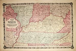
Colton's Map of Kentucky and Tennessee. with Part of Ohio, Indiana, Illinois, Missouri, Arkansas, and Other Adjoining States
Editore: New York, New York, 1861
Da: High Ridge Books, Inc. - ABAA, South Deerfield, MA, U.S.A.
Membro dell'associazione: ABAA ESA ILAB SNEAB
Valutazione venditore:
This map, labeled No. 4 at the top left, apparently was removed from the same source as the preceding map. On this map, only the principal cities in Kentucky (along with Memphis, St. Louis and Little Rock) have been underlined. It has the same borderof wheat and flowers.
-
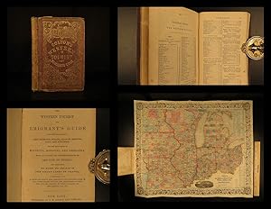
The Western Tourist and Emigrant's Guide through the States of Ohio, Michigan, Indiana, Illinois, and Missouri, Iowa and Wisconsin, and the Territories of Minesota [sic.], Missouri, and Nebraska . Accompanied with a large and minute Map
Editore: published by J.H. Colton, New York, 1852
Da: Donald A. Heald Rare Books (ABAA), New York, NY, U.S.A.
Membro dell'associazione: ABAA ILAB
Valutazione venditore:
Mappa
89pp. plus 18pp. catalogue of maps, etc., published by Colton. Large folding map: Smith, J. Calvin: "Guide Through Ohio, Michigan, Indiana, Illinois, Missouri, Wisconsin & Iowa, Showing the Township lines of the United States Surveys, Location of Cities, Towns, Villages, Post Hamlets, Canals, Rail and Stage Roads." New York: J.H. Colton, 1852. Full period colour, 21 7/8 x 26 3/8 inches. (Front free endpaper glued down to the front pastedown, small abrasion on the title). Publisher's green cloth covers, upper cover pictorially stamped in gilt, the lower cover repeating the design in blind. Colton's Western Tourist, complete with the folding map. This 1852 edition not recorded by Howes. The map depicts the region as far west as the Missouri river. Howes S615; Ristow, p.316.
-
The Western Tourist and Emigrant's Guide through the States of Ohio, Michigan, Indiana, Illinois, and Missouri, Iowa and Wisconsin, and the Territories of Minesota, Missouri, and Nebraska. Accompanied with a large and minute Map.
Editore: J. H. Colton, New York, 1852
Da: Nat DesMarais Rare Books, ABAA, Portland, OR, U.S.A.
Membro dell'associazione: ABAA CBA ILAB
Valutazione venditore:

First edition. Unrecorded by Howes. Twelvemo. 89, [1]. 18 [publisher's ads] pp. plus the large folding map in colors bound in at rear. Publisher's morocco-grain brown cloth, front elaborately stamped in gilt, same pattern in blind on rear. A really wonderful copy.
-
The Western Tourist and Emigrant's Guide : through the states of Ohio, Michigan, Indiana, Illinois, Missouri, Iowa, and Wisconsin, and the territories of Minnesota, Missouri, and Nebraska ; being an accurate and concise description of each state and territory ; and containing the routes and distances on the great lines of travel ; accompanied with a large and minute map
Editore: J.H. Colton and Company, No. 172 William Street, 1854
Libro
Hardcover. Condizione: Near Fine. 1854 HUGE MAP Colton s Western Tourist Emigrant's Guide Americana California J.H. Colton founded an American mapmaking company in the early 1830s which became an international leader in the map publishing industry until 1890. Colton created railroad maps, immigrant guides, elaborate atlases, and more all printed using engraved steel plates, which produced higher quality prints than maps made with less costly wax engravings, which were often separately hand water colored. and were recognized for their decorative borders. J.H. Colton s Western Tourist and Emigrant's Guide is an important 19th-century geographical book with an enormous folding map of the American west including Ohio, Missouri, Indiana and Wisconsin. According to Howes, this work includes descriptions and material on California, Oregon, and Texas, with overland routes and westward expansion. Item number: #13174 Price: $750 COLTON, J.H. The Western Tourist and Emigrant's Guide : through the states of Ohio, Michigan, Indiana, Illinois, Missouri, Iowa, and Wisconsin, and the territories of Minnesota, Missouri, and Nebraska ; being an accurate and concise description of each state and territory ; and containing the routes and distances on the great lines of travel ; accompanied with a large and minute map . New York: J.H. Colton and Company, No. 172 William Street, 1854. Details: Collation: Complete with all pages 89, [1], 23, [5] Huge folding color map 26.5in x 21.5in (67cm x 54.5cm) References: Howes C 623; Howes S 615; Graff 3852; Sabin 82932; Provenance: Handwritten Clarence J. Shultz Language: English Binding: Hardcover; tight & secure Cloth Size: ~6in X 4in (15cm x 10cm) Our Guarantee: Very Fast. Very Safe. Free Shipping Worldwide. Customer satisfaction is our priority! Notify us with 7 days of receiving, and we will offer a full refund without reservation! 13174 Photos available upon request.
-
THE WESTERN TOURIST AND EMIGRANT'S GUIDE THROUGH THE STATES OF OHIO, MICHIGAN, INDIANA, ILLINOIS, MISSOURI, IOWA, AND WISCONSIN, AND THE TERRITORIES OF MINESOTA, MISSOURI, AND NEBRASKA. BEING AN ACCURATE AND CONCISE DESCRIPTION OF EACH STATE AND TERRITORY; AND CONTAINING THE ROUTES AND DISTANCES ON THE GREAT LINES OF TRAVEL. ACCOMPANIED WITH A LARGE AND MINUTE MAP, EXHIBITING THE TOWNSHIP LINES OF THE UNITED STATES' SURVEYS, THE BOUNDARIES OF COUNTIES, AND THE POSITION OF CITIES, VILLAGES AND SETTLEMENTS, ETC., ETC.
Editore: J.H. Colton, New York, 1856
Da: David M. Lesser, ABAA, Woodbridge, CT, U.S.A.
Membro dell'associazione: ABAA ESA ILAB SNEAB
Valutazione venditore:
Bound in original gilt-decorated publisher's cloth, with title stamped in gilt on front cover and in blind on rear cover. Spine cloth missing but covers firm [extremities rubbed]. 89, [1 blank], 34, [1], [1 blank] pp. A clean text with occasional mild foxing. The large folding map, attached to the rear pastedown, has a few short edge splits. It is hand-colored and entitled, 'Guide Through Ohio, Michigan, Indiana, Illinois, Missouri, Wisconsin & Iowa.by J. Calvin Smith. New York: J.H. Colton. 1855.' Very Good. Howes S615. Apparently not at AAS as of September 2021.
-
The Western Tourist and Emigrant's Guide through the States of Ohio, Michigan, Indiana, Illinois, Missouri, Iowa, and Wisconsin and the territories of Minesota [sic], Missouri, and Nebraska. Being an Accurate and Concise Description of each State and Territory and Containing the Routes and Distances on the Great Lines of Travel. Accompanied with a large and minute map, exhibiting the township lines of the United States' surveys, the boundaries of counties, and the position of cities, villages and settlements, etc.,.
Editore: J.H. Colton, New York, 1852
Da: Nat DesMarais Rare Books, ABAA, Portland, OR, U.S.A.
Membro dell'associazione: ABAA CBA ILAB
Valutazione venditore:
First edition. Twelvemo. 89, [1], 18 [publisher's ads] pp. Hand-colored fold-out map with engraved hand-colored ornate floral border, 20 x 26 inches, affixed at rear (as issued). Publisher's brown cloth with large and decorative gilt stamping and lettering on front, same image embossed in blind on rear. A virtually flawless copy; cloth with no rubbing or chipping, text extremely clean and map in beautiful shape.

![Immagine del venditore per The Western Tourist and Emigrant's Guide through the States of Ohio, Michigan, Indiana, Illinois, and Missouri, Iowa and Wisconsin, and the Territories of Minesota [sic.], Missouri, and Nebraska . Accompanied with a large and minute Map venduto da Donald A. Heald Rare Books (ABAA)](https://pictures.abebooks.com/inventory/md/md2156490546.jpg)