
Importo totale (1 articolo articoli):
Destinazione ordine:

map showing present boundaries ojibwa di eastman capt seth williams (1 risultati)
Vai alla pagina principale dei risultati di ricerca
Filtri di ricerca
Tipo di articolo
- Tutti i tipi di prodotto
- Libri (1)
- Riviste e Giornali (Nessun altro risultato corrispondente a questo perfezionamento)
- Fumetti (Nessun altro risultato corrispondente a questo perfezionamento)
- Spartiti (Nessun altro risultato corrispondente a questo perfezionamento)
- Arte, Stampe e Poster (Nessun altro risultato corrispondente a questo perfezionamento)
- Fotografie (Nessun altro risultato corrispondente a questo perfezionamento)
- Mappe (Nessun altro risultato corrispondente a questo perfezionamento)
- Manoscritti e Collezionismo cartaceo (Nessun altro risultato corrispondente a questo perfezionamento)
Condizioni Maggiori informazioni
- Nuovo (Nessun altro risultato corrispondente a questo perfezionamento)
- Come nuovo, Ottimo o Quasi ottimo (Nessun altro risultato corrispondente a questo perfezionamento)
- Molto buono o Buono (Nessun altro risultato corrispondente a questo perfezionamento)
- Discreto o Mediocre (Nessun altro risultato corrispondente a questo perfezionamento)
- Come descritto (1)
Legatura
- Tutte
- Rilegato (Nessun altro risultato corrispondente a questo perfezionamento)
- Brossura (Nessun altro risultato corrispondente a questo perfezionamento)
Ulteriori caratteristiche
- Prima ed. (Nessun altro risultato corrispondente a questo perfezionamento)
- Copia autograf. (Nessun altro risultato corrispondente a questo perfezionamento)
- Sovracoperta (Nessun altro risultato corrispondente a questo perfezionamento)
- Con foto (1)
- Non Print on Demand (1)
Lingua (1)
Prezzo
- Qualsiasi prezzo
- Inferiore a EUR 20 (Nessun altro risultato corrispondente a questo perfezionamento)
- EUR 20 a EUR 45 (Nessun altro risultato corrispondente a questo perfezionamento)
- Superiore a EUR 45
Spedizione gratuita
- Spedizione gratuita in U.S.A. (Nessun altro risultato corrispondente a questo perfezionamento)
Paese del venditore
Valutazione venditore
-
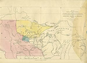
Map showing the present Boundaries of the Ojibwa, Menomonee, Winnebago, and Dacotah Tribes of Indians 1851
Editore: Lippincott, Grambo & Co., Philadelphia, 1852
Da: Antipodean Books, Maps & Prints, ABAA, Garrison, NY, U.S.A.
Membro dell'associazione: ABAA ANZAAB ESA ILAB
Valutazione del venditore 5 su 5 stelle

Condizione: Otherwise very good condition. Native American territory boundaries in the Midwest, east of the Missouri River to the Great Lakes. Territories in color, waterways identified, and forts: Fort Ripley, Fort Snelling, Fort Winnebago, Fort Williams. Seth Eastman, graduate of West Point, spent extended time out West, having a Native American family that he disowned when he was stationed elsewhere. He became the drawing instructor at West Point, and is known primarily for his his paintings of Native Americans. From West to East from Missouri River to Lake Huron, North from Lake Winnepec to Prairie du Chien. The northern border of Iowa is on the bottom of the page, no other state identified. Color lithograph, Plate 31 at the upper right. Page size 12 1/4 x 9 1/8". Some discoloration to right side of map.