Importo totale (1 articolo articoli):
Destinazione ordine:

new england di rand mcnally (78 risultati)
Vai alla pagina principale dei risultati di ricerca
Tipo di articolo
- Tutti gli articoli
- Libri (75)
- Riviste e Giornali
- Fumetti
- Spartiti
- Arte, Stampe e Poster
- Fotografie
- Mappe (3)
-
Manoscritti e
Collezionismo cartaceo
Condizioni
Legatura
Ulteriori caratteristiche
- Prima edizione (1)
- Copia autografata
- Sovraccoperta
- Con foto (11)
- No print on demand
Paese del venditore
Valutazione venditore
-
Rand McNally Folded Map: New England (Sheet Map, Folded)
Editore: Rand McNally 10/11/2021, 2021
ISBN 10: 0528025775ISBN 13: 9780528025778
Libro
Sheet Map, Folded. Condizione: New. Rand McNally Folded Map: New England 0.13. Book.
Ulteriori offerte da altri venditori AbeBooks
Nuovo - A partire da EUR 8,50
Usato - A partire da EUR 11,26
Scopri anche Brossura
-

Rand McNally Easy To Fold: New England
Editore: Rand McNally (edition Laminated Map), 2013
ISBN 10: 0528998382ISBN 13: 9780528998386
Libro
Map. Condizione: Very Good. Laminated Map. Ship within 24hrs. Satisfaction 100% guaranteed. APO/FPO addresses supported.
Ulteriori offerte da altri venditori AbeBooks
Nuovo - A partire da EUR 26,96
Usato - A partire da EUR 9,33
Scopri anche Brossura
-

Rand McNally Easy to Fold: New England Laminated Map (Sheet Map, Folded)
Editore: Rand McNally 5/6/2022, 2022
ISBN 10: 0528026151ISBN 13: 9780528026157
Libro
Sheet Map, Folded. Condizione: New. Rand McNally Easy to Fold: New England Laminated Map 0.35. Book.
Ulteriori offerte da altri venditori AbeBooks
Nuovo - A partire da EUR 9,99
Usato - A partire da EUR 11,83
Scopri anche Brossura
-

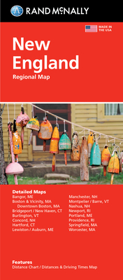
Rand McNally New England Regional Map
Editore: Rand McNally, 2013
ISBN 10: 052888185XISBN 13: 9780528881855
Libro
Paperback. Condizione: Good. The book has been read but remains in clean condition. All pages are intact and the cover is intact. Some minor wear to the spine.
Ulteriori offerte da altri venditori AbeBooks
Nuovo - A partire da EUR 24,94
Usato - A partire da EUR 6,01
Scopri anche Brossura
-

New England Regional Map
Editore: Rand McNally & Co ,U.S., 2003
ISBN 10: 0528998374ISBN 13: 9780528998379
Libro
map. Condizione: Good. All orders are dispatched the following working day from our UK warehouse. Established in 2004, we have over 500,000 books in stock. No quibble refund if not completely satisfied.
-
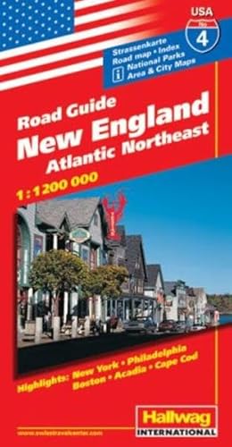
Hallwag USA Road Guide, No.4, New England: Atlantic Northeast. Area and City Maps. National Parks. Index. Highlights: New York, Philadelphia, Boston, Acadia, Cape Cod
Editore: Hallwag Maps, 2012
ISBN 10: 3828302467ISBN 13: 9783828302464
Libro
Befriedigend/Good: Durchschnittlich erhaltenes Buch bzw. Schutzumschlag mit Gebrauchsspuren, aber vollständigen Seiten. / Describes the average WORN book or dust jacket that has all the pages present.
-

Condizione: Very Good. Rand McNally published Texaco Road Map 1933. Appx. 28" by 28". Pretty nice, a few half inch tears along seams.
-
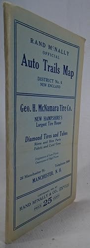
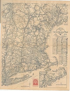
Rand McNally Offical Auto Trails Map District No. 6 New England
Editore: Rand McNally, Chicago and New York, 1923
Da: Yesterday's Gallery, ABAA, East Woodstock, CT, U.S.A.
Membro dell'associazione: ABAA ILAB
Valutazione venditore:

Soft cover. Small Duodecimo. Large folding map in wrappers. Very good, outter edges of wrappers faded.
-
Rand McNally & Company's Handy Guide to the New England States
Editore: Rand, McNally & Co., Chicago, 1897
Prima edizione
First Edition. Great old ads on first few pages and last few pages. An exeptional copy: the covers have no wear whatsoever. Internally the book is in fine condition and all maps are clean and bright -- none appear to ever have been opened. A near fine copy -- overall c We provide PROTECTIVE packaging. Photos of our books are always available upon request. SELLING USED AND RARE BOOKS ON ABE SINCE 1997. GERMAN & FRENCH CUSTOMERS PLEASE CONTACT US USING THE LINK ABOVE.
-
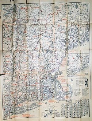
Official 1923 Auto Trail Map District Number 6, New England and Eastern New York
Editore: Chicago, Chicago, 1923
Da: High Ridge Books, Inc. - ABAA, South Deerfield, MA, U.S.A.
Membro dell'associazione: ABAA ESA ILAB SNEAB
Valutazione venditore:
Folding map, possibly removed from a guide book, of New England and the eastern portion of New York. Fine condition, with small separations at some fold junctions. Printed in red and blue. Designed for automobile travelers, with roads identified by route number and quality of road surface. Dozens of hotels, inns and garages are identified. At the lower right is a key for various auto trails and routes, each of which has a distinctive pattern on signs marking the route.
-
New England Transportation Company Operated and Affiliated Lines
Editore: Rand McNally & Co, New York, 1927
Mappa
13 1/4 x 8 1/4 inches. Condizione: Very good condition. This is a very attractive small scale map showing the Lines, owned and affiliated, of the New England Transportation Co. It is a brochure, on the verso of the map, that touts the safety and maintenance of the buses of the company. Included is a scheduleSee pics.
-
Rand McNally Official 1920 Auto Trails Map District Number 6 New England Eastern New York - The transition from auto trails to numbered routes.
Data di pubblicazione: 1920
Da: Curtis Wright Maps, Berwyn, IL, U.S.A.
Membro dell'associazione: ESA MWABA
Valutazione venditore:

Condizione: Very Good. "This engaging road map covers a broad region along the Atlantic coast between New York and Maine, with an inset in the lower right extending the image to the Canadian border. It was published in Chicago, Illinois by Rand McNally in 1920 and distributed to promote the products of the Socony Oil Company, one of the 34 operators established as a result of Standard Oil's Supreme Court-mandated dissolution in 1911. Nearly 100 different markings for various auto trails are identified immediately below the title block, reflecting the decentralized and haphazard method of organizing and promoting road construction. Though Wisconsin established numbered state highways in 1917, it wasn't until the Federal Aid Highway Act of 1921 (The Phipps Act) that a coherent plan for the nation's roads was first proposed. Distances between points are noted and several advertisements for Socony products can be seen on the covers and within the image. Source." Sheet Width (in) 21.75 Sheet Height (in) 27.75 Condition Description Pocket map folded into 24 panels and affixed to original stiff illustrated paper wraps. Light creasing and some moderate toning along fold lines, and scattered soiling in the upper left (where affixed to the covers), in the lower left (near Long Island), and in the upper right (in the margin). Good to very good overall.