Importo totale (1 articolo articoli):
Destinazione ordine:

terres arctiques (63 risultati)
Vai alla pagina principale dei risultati di ricerca
Tipo di articolo
- Tutti i tipi di prodotto
- Libri (30)
- Riviste e Giornali (3)
- Fumetti
- Spartiti
- Arte, Stampe e Poster (9)
- Fotografie
- Mappe (21)
- Manoscritti e Collezionismo cartaceo
Condizioni
Legatura
Ulteriori caratteristiche
- Prima ed. (1)
- Copia autograf.
- Sovracoperta (1)
- Con foto (46)
- Non Print on Demand (61)
Spedizione gratuita
- Spedizione gratuita negli USA
Paese del venditore
Valutazione venditore
-

Terres arctiques : Un monde immense, sauvage et vulnérable
Editore: Editions du Rouergue, 2009
ISBN 10: 2812600489ISBN 13: 9782812600487
Libro
Hardcover. Condizione: Bon. Ancien livre de bibliothčque. Légčres traces d'usure sur la couverture. Edition 2009. Ammareal reverse jusqu'ŕ 15% du prix net de cet article ŕ des organisations caritatives. ENGLISH DESCRIPTION Book Condition: Used, Good. Former library book. Slight signs of wear on the cover. Edition 2009. Ammareal gives back up to 15% of this item's net price to charity organizations.
Ulteriori offerte da altri venditori AbeBooks
Nuovo - A partire da EUR 14,36
Usato - A partire da EUR 7,65
-

Condizione: Assez bon. Merci, votre achat aide ŕ financer des programmes de lutte contre l'illettrisme.
-

TERRES ARCTIQUES Un Monde Immense Sauvage et Vulnérable
Editore: Editions du Rouergue, 2009, 2009
Da: Rothwell & Dunworth (ABA, ILAB), Dulverton, Regno Unito
Membro dell'associazione: ABA ILAB
Valutazione venditore:

4to. Original laminated pictorial boards (Fine), dustwrapper (Fine). Pp. 188, illus with coloured photos and map (no inscriptions).
-

L'arche des Inukshuk: Roman écologique en terres arctiques (French Edition)
Editore: Editions L'Harmattan, 2021
ISBN 10: 2343228167ISBN 13: 9782343228167
Libro
Condizione: Neuf.
-
![Immagine del venditore per La Geographie moderne, naturelle historique & politique : dans une methode nouvelle & aisee / par . Abraham Du Bois . ; divisee en quatre tomes ; avec plusieurs cartes & une table des matieres ; tome quatrieme, contenant l'Afrique, l'Amerique, & les Terres inconnues, Arctiques, & Antarctiques (1748) [Leatherbound] venduto da S N Books World](https://pictures.abebooks.com/inventory/md/md30638574809.jpg)
La Geographie moderne, naturelle historique & politique : dans une methode nouvelle & aisee / par . Abraham Du Bois . ; divisee en quatre tomes ; avec plusieurs cartes & une table des matieres ; tome quatrieme, contenant l'Afrique, l'Amerique, & les Terres inconnues, Arctiques, & Antarctiques (1748) [Leatherbound]
Data di pubblicazione: 2022
Libro Print on Demand
Leatherbound. Condizione: NEW. Leatherbound edition. Condition: New. Leather Binding on Spine and Corners with Golden leaf printing on spine. Bound in genuine leather with Satin ribbon page markers and Spine with raised gilt bands. A perfect gift for your loved ones. Reprinted from 1748 edition. NO changes have been made to the original text. This is NOT a retyped or an ocr'd reprint. Illustrations, Index, if any, are included in black and white. Each page is checked manually before printing. As this print on demand book is reprinted from a very old book, there could be some missing or flawed pages, but we always try to make the book as complete as possible. Fold-outs, if any, are not part of the book. If the original book was published in multiple volumes then this reprint is of only one volume, not the whole set. IF YOU WISH TO ORDER PARTICULAR VOLUME OR ALL THE VOLUMES YOU CAN CONTACT US. Resized as per current standards. Sewing binding for longer life, where the book block is actually sewn (smythe sewn/section sewn) with thread before binding which results in a more durable type of binding. Pages: 276 Language: French Pages: 276.
-

Terres arctiques : terres d'avenir - Actualités documents pour la classe n°158 8-10-64.
Editore: Institut pédagogique national, 1964
Pas de couverture. Condizione: bon. R320153664: 1964. In-4. En feuillets. Bon état, Livré sans Couverture, Dos satisfaisant, Intérieur frais. 8 pages - quelques illustrations en noir et blanc. . . . Classification Dewey : 370-Education.
-
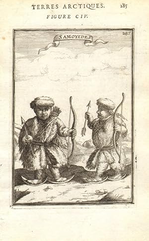
Condizione: Good. RUSSIAN ARCTIC. 'Samoyedes'. Samoyedic people. Snow shoes. Bows. MALLET 1683. Original 17th century copperplate print; Allain Manesson Mallet (1683). Overall page size 13 x 21cm approximately (5 x 8 inches); image size 10.5 x 14.5cm approximately (4 x 5.5 inches). Condition: Good. The image shown may have been taken from a different example of this print than that which is offered for sale. The print you will receive is in good condition but there may be minor variations in the condition from that shown in the image. There are images and/or text printed on the reverse side. Overall page size 13 x 21cm approximately (5 x 8 inches); image size 10.5 x 14.5cm approximately (4 x 5.5 inches).
-

A TRAVERS LE MONDE N° 16 - Aux terres Arctiques - Du golfe Inglefield a la Baie Melville - Eivind Astrup, Dans le Togo Allemand - LA race noire du pays d'Adeli, En egypte - Fouilles du prof, Flinders Petrie, Au Japon - Itskou, l'Ile sacrée, Kobé
Editore: LIBRAIRIE HACHETTE & CIE 20 AVRIL 1895, 1895
Rivista / Giornale
Couverture souple. Condizione: bon. R110083016: 20 AVRIL 1895. In-12. Broché. Bon état, Livré sans Couverture, Dos satisfaisant, Intérieur frais. Paginé de 153 ŕ 160. Quelques gravures en noir et blanc dans le texte. . . . Classification Dewey : 70.49-Presse illustrée, magazines, revues.
-

A TRAVERS LE MONDE N° 28 - Le musée San Martino a Naples, Les morts de Sikasso, La guerre et l'amérique, Explorations Danoises dans les terres arctiques, Comment atteindre le pole ? - Opinion de Nansen, La phrase : Voir Naples et mourir
Editore: LIBRAIRIE HACHETTE & CIE 9 JUILLET 1898, 1898
Rivista / Giornale
Couverture souple. Condizione: bon. R110083184: 9 JUILLET 1898. In-12. Broché. Bon état, Livré sans Couverture, Dos satisfaisant, Intérieur frais. Paginé de 217 ŕ 224. Quelques gravures en noir et blanc dans le texte. . . . Classification Dewey : 70.49-Presse illustrée, magazines, revues.
-

Le musée des familles - lecture du soir - 1čre série - livraison n°02 - Voyage aux terres arctiques.
Editore: Bureaux du musée des familles , 18 rue des moulins. janvier 1834, 1834
Couverture souple. Condizione: bon. RO10047244: janvier 1834. In-12. Broché. Bon état, Couv. convenable, Dos satisfaisant, Quelques rousseurs. 8 pages environ, illustrées de gravures noir et blanc dans le texte. Paginées de 9 ŕ 16. . . . Classification Dewey : 70.4415-La famille / Semaine et musée des familles.
-

Le musée des familles - lecture du soir - 1čre série - livraison n°04 - Voyages aux terres arctiques - Les esquimaux.
Editore: Bureaux du musée des familles , 18 rue des moulins. janvier 1834, 1834
Couverture souple. Condizione: bon. RO10047246: janvier 1834. In-12. Broché. Bon état, Couv. convenable, Dos satisfaisant, Quelques rousseurs. 8 pages environ, illustrées de gravures noir et blanc dans le texte. Paginées de 25 ŕ 32. . . . Classification Dewey : 70.4415-La famille / Semaine et musée des familles.
-
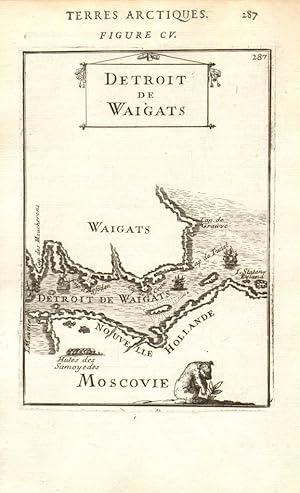
Condizione: Good. RUSSIAN ARCTIC. Detroit Waigats Yugorsky Strait. Vaygach Island. MALLET 1683 map. Original 17th century copperplate map; Allain Manesson Mallet (1683). Overall page size 13 x 21cm approximately (5 x 8 inches); image size 10.5 x 14.5cm approximately (4 x 5.5 inches). Condition: Good. The image shown may have been taken from a different example of this map than that which is offered for sale. The map you will receive is in good condition but there may be minor variations in the condition from that shown in the image. There are images and/or text printed on the reverse side. Overall page size 13 x 21cm approximately (5 x 8 inches); image size 10.5 x 14.5cm approximately (4 x 5.5 inches).
-
Condizione: Good. RUSSIAN ARCTIC. Isle Etats (Ostrov Mestnyy) Isle Maurice (Dolgy Island) 1683 map. Original 17th century copperplate map; Allain Manesson Mallet (1683). Overall page size 13 x 21cm approximately (5 x 8 inches); image size 10.5 x 14.5cm approximately (4 x 5.5 inches). Condition: Good. The image shown may have been taken from a different example of this map than that which is offered for sale. The map you will receive is in good condition but there may be minor variations in the condition from that shown in the image. There are images and/or text printed on the reverse side. Overall page size 13 x 21cm approximately (5 x 8 inches); image size 10.5 x 14.5cm approximately (4 x 5.5 inches).
-

Condizione: Good. RUSSIAN ARCTIC. 'Zemblien'. Nenet. Inhabitant of Vaygach Island. MALLET 1683. Original 17th century copperplate print; Allain Manesson Mallet (1683). Overall page size 13 x 21cm approximately (5 x 8 inches); image size 10.5 x 14.5cm approximately (4 x 5.5 inches). Condition: Good. The image shown may have been taken from a different example of this print than that which is offered for sale. The print you will receive is in good condition but there may be minor variations in the condition from that shown in the image. There are images and/or text printed on the reverse side. Overall page size 13 x 21cm approximately (5 x 8 inches); image size 10.5 x 14.5cm approximately (4 x 5.5 inches).
-

LA VIE AU NORD DU CERCLE POLAIRE ARCTIQUE / L'Appel Du Nord. - Les Femmes Dans L'Arctique. - Problčmes Polaires. - Médecins et Missionaires. - La Mise en Culture des Terres Arctiques. - L'ötreinte de la Banquise. - Le Grand Nord Russe. - Le Grand Nord.
Editore: PAYOT, 1954
Couverture souple. Condizione: bon. R320075481: 1954. In-8. Broché. Bon état, Couv. convenable, Dos satisfaisant, Intérieur frais. 240 pages. . . . Classification Dewey : 998-Iles de l'Arctique et de l'Antarctique.
-

Je sais tout du 15 octobre 1922-Sommaire: Les grands travaux français: Le Tunnel des Batignolles- Rasmussen aux terres arctiques, Le vol ŕ voile, La chasse aux orchidée; A la recherche du Temps, Le "Dispatching", "Phroso"- etc.
Editore: Pierre Lafitte, 1922
Rivista / Giornale
Couverture souple. Condizione: bon. RO30323442: 1922. In-4. Broché. Etat d'usage, Couv. légčrement passée, Dos abîmé, Papier jauni. Environ 150 pages. Nombreuses illustrations et photos en noir et blanc, dans et hors texte. Déchirures et manques aux dos. . . . Classification Dewey : 70.49-Presse illustrée, magazines, revues.
-

Éditions Larousse, 1987. In-8° cartonné avec couverture illustrée, riche iconographie et 127 pages avec bibliographie, en trčs bon état.
-
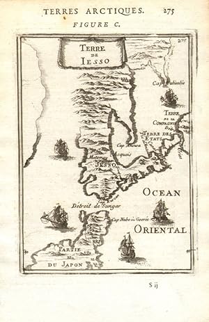
Condizione: Fair. JAPAN Terre de Yesso (Hokkaido). Sungar (Tsugaru) strait. Honshu MALLET 1683 map. Original 17th century copperplate map; Allain Manesson Mallet (1683). Overall page size 13 x 21cm approximately (5 x 8 inches); image size 10.5 x 14.5cm approximately (4 x 5.5 inches). Condition: Fair: Blemish; The page title, page number and figure number have been printed upside down at the bottom of the page. The image shown may have been taken from a different example of this map than that which is offered for sale. Any flaws described in this statement may not be visible on the image but will be present on the map you receive. . There are images and/or text printed on the reverse side. Overall page size 13 x 21cm approximately (5 x 8 inches); image size 10.5 x 14.5cm approximately (4 x 5.5 inches).
-

L'Art Chez les Peuples Primitifs: Afrique - Oceanie - Archipel Malais - Amerique et Terres Arctiques Styles et Civilisations
Editore: Librairie de France, Paris, 1929
Libro
Paperback. Condizione: Fair. Softcover. Poor binding. Lacking rear wrap and spine. Front wrap detached. Sold with all faults. 106 p. ; 28 cm.
-
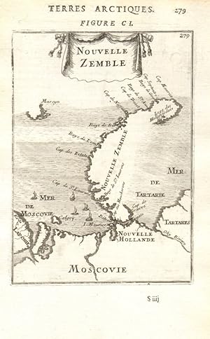
Condizione: Good. RUSSIAN ARCTIC Nouvelle Zemble Novaya Zemlya Kara/Barents Seas. MALLET 1683 map. Original 17th century copperplate map; Allain Manesson Mallet (1683). Overall page size 13 x 21cm approximately (5 x 8 inches); image size 10.5 x 14.5cm approximately (4 x 5.5 inches). Condition: Good. The image shown may have been taken from a different example of this map than that which is offered for sale. The map you will receive is in good condition but there may be minor variations in the condition from that shown in the image. There are images and/or text printed on the reverse side. Shows Novaya Zemlya (Nova Zebla) with an incomplete coastline. The Russians knew of Novaya Zemlya from the 11th century, when hunters from Novgorod visited the area. For western Europeans, the search for the Northern Sea Route in the 16th century led to its exploration. The first visit from a west European was by Hugh Willoughby in 1553, and he met Russian ships from the already established hunting trade. Dutch explorer Willem Barentsz reached the west coast of Novaya Zemlya in 1594, and in a subsequent expedition of 1596 rounded the northern point and wintered on the northeast coast. (Barentsz died during the expedition, and may have been buried on the northern island. During a later voyage by Fyodor Litke in 18211824, the west coast was mapped. Henry Hudson was another explorer who passed through Novaya Zemlya while searching for the Northeast Passage. Overall page size 13 x 21cm approximately (5 x 8 inches); image size 10.5 x 14.5cm approximately (4 x 5.5 inches).
-
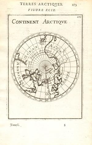
Condizione: Good. ARCTIC. Terres Arctiques. Continent Arctique. North Pole. MALLET 1683 old map. Original 17th century copperplate map; Allain Manesson Mallet (1683). Overall page size 13 x 21cm approximately (5 x 8 inches); image size 10.5 x 14.5cm approximately (4 x 5.5 inches). Condition: Good. The image shown may have been taken from a different example of this map than that which is offered for sale. The map you will receive is in good condition but there may be minor variations in the condition from that shown in the image. There are images and/or text printed on the reverse side. Includes part of North America. Overall page size 13 x 21cm approximately (5 x 8 inches); image size 10.5 x 14.5cm approximately (4 x 5.5 inches).
-

Carte qui represente les différentes connoissances que l'on a eues des Terres Arctiques depuis 1650 jusqu'en 1747 ausquelles il faut comparer la carte suivante Ce. 10
Data di pubblicazione: 1773
Mappa
Condizione: Gut. Kartenblatt aus Diderot's Enzyklopädie, eines der wichtigsten Sammelwerke für das Wissen dieser Zeit. Das Blatt enthält 4 Karten der arktischen Region, jeweils in der Größe von ca. 14 x 18 cm und im Maßstab 1:250000000 bzw. 1:20000000 (Ellis). Im einzelnen: (Nicolas) Sanson im Jahr 1650 (die Überschrift besagt fälschlicherweise 1750), (Joseph-Nicolas) Delisle im Jahr 1700, Delisle im Jahr 1703, Carte de la Baye d'Hudson parcourue en 1746 et 1747 par Henri Ellis pour la recherche du passage par le Nord-Ouest. Karte auf dickem Papier, mehrfach gefaltet, mit kleinen Einrissen am unteren Rand, Knick am unteren linken Eck, am obren Rand leicht verstaubt/staubfleckig, ansonsten gut. Sprache / Language: fr 1 Seiten. ca. 38 x 42,3 cm.
-
L'Art Chez les Peuples Primitifs: Afrique - Oceanie - Archipel Malais - Amerique et Terres Arctiques Styles et Civilisations
Editore: Paris: Librairie de France, 1929., 1929
83 pages + 106 pages of B&W plates, 8 3/4" x 10 3/4", softcover, (joints strengthened with tape, some toning in very good condition). In French.
-
Condizione: Good. GREENLAND. 'Groenlande'. Baffin Bay & Island. Newfoundland. MALLET 1683 map. Original 17th century copperplate map; Allain Manesson Mallet (1683). Overall page size 13 x 21cm approximately (5 x 8 inches); image size 10.5 x 14.5cm approximately (4 x 5.5 inches). Condition: Good. The image shown may have been taken from a different example of this map than that which is offered for sale. The map you will receive is in good condition but there may be minor variations in the condition from that shown in the image. There are images and/or text printed on the reverse side. The map covers the area from the St. Lawrence to Baffin Bay and Greenland itself. Overall page size 13 x 21cm approximately (5 x 8 inches); image size 10.5 x 14.5cm approximately (4 x 5.5 inches).
-

Condizione: Good. NOVAYA ZEMLYA. Barentsz 1597 expedition attacked by wolves & bears. MALLET 1683. Original 17th century copperplate print; Allain Manesson Mallet (1683). Overall page size 13 x 21cm approximately (5 x 8 inches); image size 10.5 x 14.5cm approximately (4 x 5.5 inches). Condition: Good. The image shown may have been taken from a different example of this print than that which is offered for sale. The print you will receive is in good condition but there may be minor variations in the condition from that shown in the image. There are images and/or text printed on the reverse side. Shows the cabin and ship of the Dutch arctic expedition of Barentsz on Novaya Zemlya (Nova Zembla), with the party being attacked by (and in some cases apparently eaten by) bears and wolves. Dutch explorer Willem Barentsz reached the west coast of Novaya Zemlya in 1594, and in a subsequent expedition of 1596 rounded the northern point and wintered on the northeast coast. Barentsz died during the expedition, and may have been buried on the northern island. Overall page size 13 x 21cm approximately (5 x 8 inches); image size 10.5 x 14.5cm approximately (4 x 5.5 inches).
-
Amérique anglaise et Terres arctiques. Kol. Stahlstichkarte von A.H. Dufour bei Gustave Barba, 1855.
Arte / Stampa / Poster
Hardcover. 24 x 31,5 cm. Zeigt das Gebiet zwischen San Francisco u. Philadelphia im Süden und dem Polarmeer im Norden. 6903 [L] Sprache: Französisch Gewicht in Gramm: 50.
-

Condizione: Good. ICELAND. 'Hecla en Islande'. Hekla volcano erupting. Whaling. MALLET 1683. Original 17th century copperplate print; Allain Manesson Mallet (1683). Overall page size 13 x 21cm approximately (5 x 8 inches); image size 10.5 x 14.5cm approximately (4 x 5.5 inches). Condition: Good. The image shown may have been taken from a different example of this print than that which is offered for sale. The print you will receive is in good condition but there may be minor variations in the condition from that shown in the image. There are images and/or text printed on the reverse side. Overall page size 13 x 21cm approximately (5 x 8 inches); image size 10.5 x 14.5cm approximately (4 x 5.5 inches).
-
L'art chez les peuples primitifs. Afrique - Océanie - Archipel Malais - Amérique et Terres Arctiques - Styles et Civilisations.
Editore: Paris. Librairie de France, 1929
Libro
Couverture rigide. Condizione: Bon. In-4°. Reliure moderne ŕ la Bradel. Couvertures conservées. 80 pages. Importante bibliographie. 106 planches hors-texte en noir : Afrique (60), Australie et Océanie (28), Archipel malais (6), Amériques et Terres arctiques (12).
-
L'Art Chez les Peuples Primitifs: Afrique - Oceanie - Archipel Malais - Amerique et Terres Arctiques Styles et Civilisations
Editore: Librairie de France, Paris, 1929
Libro
Paperback. Condizione: Very Good. Covers rebound in soft cover. Inscribed on front liner page by Basler to Claude Roger Marx (?). Former owner's neat embossed identification on front liner page. 83 pages text plus 106 black & white plates of numerous photos. Text in French. U.S. orders are shipped from N.Y. state.
-

Carte qui Represente les Differentes Commoissances que l'an a eues des Terres Arctiques .
Editore: Paris, Paris, 1773
Da: High Ridge Books, Inc. - ABAA, South Deerfield, MA, U.S.A.
Membro dell'associazione: ABAA ESA ILAB SNEAB
Valutazione venditore:
Supplementary map from the Diderot Encyclopedia, with 4 maps of Labrador and Hudson Bay on one sheet. Outline color, wide margins. The maps include maps of the region by Delisle and Sanson, along with one which shows Hudson Bay as depicted by the explorer Henry Ellis.