
Importo totale (1 articolo articoli):
Destinazione ordine:

BRION, DE LA TOUR, L (25 risultati)
Vai alla pagina principale dei risultati di ricerca
Tipo di articolo
- Tutti gli articoli
- Libri (25)
- Riviste e Giornali
- Fumetti
- Spartiti
- Arte, Stampe e Poster
- Fotografie
- Mappe
-
Manoscritti e
Collezionismo cartaceo
Condizioni
Legatura
- Tutte
- Rilegato
- Brossura (2)
Ulteriori caratteristiche
- Prima edizione
- Copia autografata
- Sovraccoperta
- Con foto (12)
- No print on demand (23)
Paese del venditore
Valutazione venditore
-
Atlas, et tables lmentaires de gographie, ancienne et moderne Histoire
Editore: Hachette Livre - BNF, 2016
ISBN 10: 2019554631ISBN 13: 9782019554637
Libro Print on Demand
PAP. Condizione: New. New Book. Shipped from UK. THIS BOOK IS PRINTED ON DEMAND. Established seller since 2000.
Ulteriori offerte da altri venditori AbeBooks
Nuovo - A partire da EUR 22,50
-
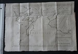
CARTE DES ISLES RHODIENNES SERVANT Ŕ L'INTELLIGENCE DE L'HISTOIRE DE MALTE (2e moitié du XVIIIe sičcle).
Da: Mesnard - Comptoir du Livre Ancien, Ruelle-sur-Touvre, Francia
Valutazione venditore:

1 carte sur papier d'époque 23,5 x 34,3 cm (partie gravée) - Trčs bel état. NOTICE FOR FOREIGN CUSTOMERS : The ECONOMIC SHIPPING RATE is reserved by FRENCH POST for books whose weight is less than 2KG ! We have limited too this offer for books whose value is less than 30 euros. Shipping will increase if you choose this rate for a value or heavy book. If you select a Paypal payment in this particular case we cannot change the shipping rate on Abebooks but this one will increase in the Paypal invoice. So be careful please to select the appropriate shipping rate taking into consideration the book value or the weight or both.
-
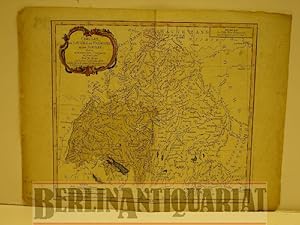
Cercles de Bavičre, de Franconie et de Souabe: divisés en toute leur Principautés et provinces. Altkolorierter Kupferstich mit Flächenkolorit.
Editore: Desnos, Paris, 1765
Da: BerlinAntiquariat, Karl-Heinz Than, Berlin, Germania
Membro dell'associazione: ILAB VDA
Valutazione venditore:
Mit einer Kartusche und mit einer farbigen Schmuckleiste eingefaßt. Mittig einmal gefaltet. Mit stärkeren Gebrauchsspuren besonders am Rand und blaue Flächen (Seen) zum Teil verwischt. Siehe Photo. Bildgröße 23,3 x 26 cm.
-

Les Gouvernamens de L'Isle de France et de Campagne et les generalites de Paris et de Chalons
Editore: 1771, 1771
Da: TABERNA LIBRARIA - ALAI - ILAB, Pistoia, Italia
Membro dell'associazione: ALAI ILAB
Valutazione venditore:

Acquaforte con bella e vivace coloritura coeva, cm. 39x55 alla battuta. Una ricca bordura decorativa a motivi floreali racchiude la mappa geografica e il descrittivo. Carta tratta da "Atlas Géneral, Civil et Ecclésiastique", Louis Brion de la Tour, 1771.
-
Les Gouvernamens de Languedoc, de Roussillon, de Foix .
Editore: 1771, 1771
Da: TABERNA LIBRARIA - ALAI - ILAB, Pistoia, Italia
Membro dell'associazione: ALAI ILAB
Valutazione venditore:
Acquaforte con bella e vivace coloritura coeva, cm. 39x55 alla battuta. Una ricca bordura decorativa a motivi floreali racchiude la mappa geografica e il descrittivo. Carta tratta da "Atlas Géneral, Civil et Ecclésiastique", Louis Brion de la Tour, 1771.
-
Gouvernament de Orleanois, de Touraine du Maine .
Editore: 1771, 1771
Da: TABERNA LIBRARIA - ALAI - ILAB, Pistoia, Italia
Membro dell'associazione: ALAI ILAB
Valutazione venditore:
Acquaforte con bella e vivace coloritura coeva, cm. 39x55 alla battuta. Una ricca bordura decorativa a motivi floreali racchiude la mappa geografica e il descrittivo. Carta tratta da "Atlas Géneral, Civil et Ecclésiastique", Louis Brion de la Tour, 1771.
-
Cercles de Westphalie, Haut et Bas Rhin.
Editore: 1766, 1766
Da: TABERNA LIBRARIA - ALAI - ILAB, Pistoia, Italia
Membro dell'associazione: ALAI ILAB
Valutazione venditore:
Acquaforte con bella e vivace coloritura coeva, cm. 39x55 alla battuta. Una ricca bordura decorativa a motivi floreali racchiude la mappa geografica e il descrittivo. Carta tratta da "Atlas Géneral, Civil et Ecclésiastique", Louis Brion de la Tour, 1766.
-
Gouvernament et Generalitč D'Alsace
Editore: 1771, 1771
Da: TABERNA LIBRARIA - ALAI - ILAB, Pistoia, Italia
Membro dell'associazione: ALAI ILAB
Valutazione venditore:
Acquaforte con bella e vivace coloritura coeva, cm. 39x55 alla battuta. Una ricca bordura decorativa a motivi floreali racchiude la mappa geografica e il descrittivo. Carta tratta da "Atlas Géneral, Civil et Ecclésiastique", Louis Brion de la Tour, 1771.
-
Gouvernaments d'Aunis, de Saintonge, de Limosin, .
Editore: 1771, 1771
Da: TABERNA LIBRARIA - ALAI - ILAB, Pistoia, Italia
Membro dell'associazione: ALAI ILAB
Valutazione venditore:
Acquaforte con bella e vivace coloritura coeva, cm. 39x55 alla battuta. Una ricca bordura decorativa a motivi floreali racchiude la mappa geografica e il descrittivo. Carta tratta da "Atlas Géneral, Civil et Ecclésiastique", Louis Brion de la Tour, 1771.
-
Gouvernament de Picardie, de Boulonnois, et d'Artois
Editore: 1771, 1771
Da: TABERNA LIBRARIA - ALAI - ILAB, Pistoia, Italia
Membro dell'associazione: ALAI ILAB
Valutazione venditore:
Acquaforte con bella e vivace coloritura coeva, cm. 39x55 alla battuta. Una ricca bordura decorativa a motivi floreali racchiude la mappa geografica e il descrittivo. Carta tratta da "Atlas Géneral, Civil et Ecclésiastique", Louis Brion de la Tour, 1771.
-
Pays-Bas François comprenant les Gouvernemens de Flandre et d'Artois .
Editore: 1771, 1771
Da: TABERNA LIBRARIA - ALAI - ILAB, Pistoia, Italia
Membro dell'associazione: ALAI ILAB
Valutazione venditore:
Acquaforte con bella e vivace coloritura coeva, cm. 39x55 alla battuta. Una ricca bordura decorativa a motivi floreali racchiude la mappa geografica e il descrittivo. Carta tratta da "Atlas Géneral, Civil et Ecclésiastique", Louis Brion de la Tour, 1771.
-
Cercles de Baviere, de Franconie et de Squabe
Editore: 1766, 1766
Da: TABERNA LIBRARIA - ALAI - ILAB, Pistoia, Italia
Membro dell'associazione: ALAI ILAB
Valutazione venditore:
Acquaforte con bella e vivace coloritura coeva, cm. 39x55 alla battuta. Una ricca bordura decorativa a motivi floreali racchiude la mappa geografica e il descrittivo. Carta tratta da "Atlas Géneral, Civil et Ecclésiastique", Louis Brion de la Tour, 1766.
-
Schweiz. La Suisse. Divisée en ses Cantons, ses Alliés, et ses Sujets, et distinguée en Pays Catholiques, Protestans et Mixtes. Altkolorierter Kupferstich mit Grenzkolorit.
Editore: ca. 1790., Paris, 1790
Da: BerlinAntiquariat, Karl-Heinz Than, Berlin, Germania
Membro dell'associazione: ILAB VDA
Valutazione venditore:
Mittig einmal gefaltet. Geringfügig randgebräunt. Gut erhalten. - Alte Landkarte. Carte ancienne. Old map of Switzerland. Contemp. col. Surrounded by decorative border. - Foto auf Anfrage. Mit einer ornamentalen Schmuckleiste eingefaßt. Bildgröße ca. 30 x 28 cm.
-
![Immagine del venditore per Großbritannien [England]. Les Isles Britanniques. combinées avec les Itinéraires. Altkolorierter Kupferstich mit Grenzkolorit und zartem Flächenkolorit. venduto da BerlinAntiquariat, Karl-Heinz Than](https://pictures.abebooks.com/inventory/md/md614916606.jpg)
Großbritannien [England]. Les Isles Britanniques. combinées avec les Itinéraires. Altkolorierter Kupferstich mit Grenzkolorit und zartem Flächenkolorit.
Editore: Paris, 1798
Da: BerlinAntiquariat, Karl-Heinz Than, Berlin, Germania
Membro dell'associazione: ILAB VDA
Valutazione venditore:
Mit einer Kartusche und mit einer. Mittig einmal gefaltet. Geringfügig randgebräunt sowie am Rand geringfügig fleckig bzw. angeschmutzt. Kleine fehlstellige Ecke unten rechts. Sonst gut erhalten. - Alte Landkarte. Carte ancienne. Old map of the British isles. Contemp. col. Surrounded by decorative border. - Foto auf Anfrage. ornamentalen Schmuckleiste eingefaßt. Bildgröße ca. 30 x 28 cm.
-
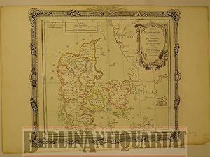
Dänemark. Le Danemark. Divisé par Provinces et Diocčses. Altkolorierter Kupferstich mit Grenzkolorit.
Editore: Paris, 1790
Da: BerlinAntiquariat, Karl-Heinz Than, Berlin, Germania
Membro dell'associazione: ILAB VDA
Valutazione venditore:
Mit einer Kartusche und mit einer. Mittig einmal gefaltet. Geringfügig randgebräunt, im unteren Bereich ein kleiner Fleck und minimal geknittert. Sonst gut erhalten. - Alte Landkarte. Carte ancienne. Old map of Denmark. Contemp. col. Surrounded by decorative border. - Foto auf Anfrage. ornamentalen Schmuckleiste eingefaßt. Bildgröße ca. 30 x 28 cm.
-
![Immagine del venditore per Türkei [europäischer Teil]. Turquie Europeénne. Avec les Pays limitrophes: ou Théatre de la guerre actuelle entre les Turcs, les Russes et L'Empéreur. Altkolorierter Kupferstich venduto da BerlinAntiquariat, Karl-Heinz Than](https://pictures.abebooks.com/inventory/md/md614916113.jpg)
Türkei [europäischer Teil]. Turquie Europeénne. Avec les Pays limitrophes: ou Théatre de la guerre actuelle entre les Turcs, les Russes et L'Empéreur. Altkolorierter Kupferstich
Editore: ca. 1770., Paris, 1770
Da: BerlinAntiquariat, Karl-Heinz Than, Berlin, Germania
Membro dell'associazione: ILAB VDA
Valutazione venditore:
Mit einer Kartusche und mit einer. Mittig einmal gefaltet. Geringfügig randgebräunt. Im unteren Bereich geringfügig angerändert. Gut erhalten. - Alte Landkarte (mit dem Kriegsschauplatz des aktuellen Krieges). Carte ancienne. Old map of european Turkey. With the theatre of actuel war. With Iceland. Contemp. col. Surrounded by decorative border. - Foto auf Anfrage. ornamentalen Schmuckleiste eingefaßt. Bildgröße ca. 30 x 28 cm.
-
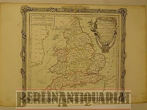
England. L'Angleterre. Divisée en 5 grande Parties, subdivisée en 52 Comtés et partagée en 2 Provinces Ecclésiastiques. England, geteilt in 5 große Teile, unterteilt in 52
Editore: Paris, 1798
Da: BerlinAntiquariat, Karl-Heinz Than, Berlin, Germania
Membro dell'associazione: ILAB VDA
Valutazione venditore:
Mit einer Kartusche und mit einer. Mittig einmal gefaltet. Geringfügig randgebräunt sowie am Rand sehr geringfügig fleckig bzw. fingerfleckig. Die beiden unteren Ecken mit kleinen Einrissen. Sonst gut erhalten. - Alte Landkarte. Carte ancienne. Old map of England, divided in 5 great parts and subdivided in 52 counties. Contemp. col. Surrounded by decorative border. - Foto auf Anfrage. und zartem Flächenkolorit. ornamentalen Schmuckleiste eingefaßt. Bildgröße ca. 30 x 28 cm. Altkolorierter Kupferstich mit Grenzkolorit.
-
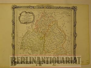
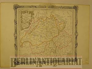
Cercles de Bavičre, de Franconie et de Souabe. Divisés en toutes leurs Principautés, et Séculičres qu' Ecclesiastiques. Altkolorierter Kupferstich mit Grenzkolorit.
Editore: Desnos, Paris, 1792
Da: BerlinAntiquariat, Karl-Heinz Than, Berlin, Germania
Membro dell'associazione: ILAB VDA
Valutazione venditore:
Mit einer Kartusche und mit einer ornamentalen Schmuckleiste eingefaßt. Mittig einmal gefaltet. Geringfügig randgebräunt. Gut erhalten. - Alte Landkarte. Carte ancienne. Old map of Germany, with Baden-Württemberg, Bavaria, Franconia and Swabia. Contemp. col. Surrounded by decorative border. - Foto auf Anfrage. Bildgröße ca. 30 x 28 cm.
-
![Immagine del venditore per Böhmen. [Mit Mähren, Schlesien, Lausitz.] Etats de Bohęme. [Avec Moravie, Silésie et Lusace.] Divisés en toutes leurs Provinces tant Civiles qu'Ecclésiastiques. Altkolorierter Kupferstich mit Grenzkolorit. venduto da BerlinAntiquariat, Karl-Heinz Than](https://pictures.abebooks.com/inventory/md/md614916101.jpg)
Böhmen. [Mit Mähren, Schlesien, Lausitz.] Etats de Bohęme. [Avec Moravie, Silésie et Lusace.] Divisés en toutes leurs Provinces tant Civiles qu'Ecclésiastiques. Altkolorierter Kupferstich mit Grenzkolorit.
Editore: Paris, 1798
Da: BerlinAntiquariat, Karl-Heinz Than, Berlin, Germania
Membro dell'associazione: ILAB VDA
Valutazione venditore:
Mit einer Kartusche und mit einer. Mittig einmal gefaltet. Geringfügig randgebräunt sowie zwei kleine Flecken am Rand. Sonst gut erhalten. - Alte Landkarte. Carte ancienne. Old map of Bohemia (with Moravia, Silesia and Lusatia). Contemp. col. Surrounded by decorative border. - Foto auf Anfrage. ornamentalen Schmuckleiste eingefaßt. Bildgröße ca. 30 x 28 cm.
-
La Denemark divisé par Provinces et Dioceses sous une Metropole
Editore: 1766, 1766
Da: TABERNA LIBRARIA - ALAI - ILAB, Pistoia, Italia
Membro dell'associazione: ALAI ILAB
Valutazione venditore:
Acquaforte con bella e vivace coloritura coeva, cm. 39x55 alla battuta. Una ricca bordura decorativa a motivi floreali racchiude la mappa geografica e il descrittivo. Carta tratta da "Atlas Géneral, Civil et Ecclésiastique", Louis Brion de la Tour, 1766.
-
L'Angleterre divisée en 5 grandes Parties, subdivisées en 52 Contés et portagée en 2 Provinces Ecclesiastiques .
Editore: 1766, 1766
Da: TABERNA LIBRARIA - ALAI - ILAB, Pistoia, Italia
Membro dell'associazione: ALAI ILAB
Valutazione venditore:
Acquaforte con bella e vivace coloritura coeva, cm. 39x55 alla battuta. Una ricca bordura decorativa a motivi floreali racchiude la mappa geografica e il descrittivo. Carta tratta da "Atlas Géneral, Civil et Ecclésiastique", Louis Brion de la Tour, 1766.
-
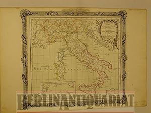
Italien. L'Italie. Divisée en tous ses Etats et assujettie aux Observations Astronomiques, combinées avec les Itinéraires. Altkolorierter Kupferstich mit Grenzkolorit.
Editore: ca. 1798., Paris, 1798
Da: BerlinAntiquariat, Karl-Heinz Than, Berlin, Germania
Membro dell'associazione: ILAB VDA
Valutazione venditore:
Mit einer Kartusche und mit einer. Mittig einmal gefaltet. Geringfügig randgebräunt. Kleiner fachgerecht hinterlegter Einriß, am Rand wenige kleine Flecke, sonst gut erhalten. - Alte Landkarte. Carte ancienne. Old map of Italy. Contemp. col. Surrounded by decorative border. - Foto auf Anfrage. ornamentalen Schmuckleiste eingefaßt. Bildgröße ca. 30 x 28 cm.
-
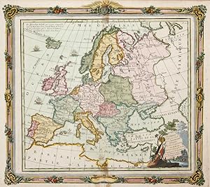
L'Europe
Editore: Artist: Brion de la Tour/ Desnos L/ LC ( - 1803 ) France ; issued in: Paris ; dated: 1766; - Louis Brion de la Tour was a french cartographer and demographer With his knowledgebacame the famous « Ingénieur Géographe du Roi »He issued together with Louis Charles Desnos (1750-1790) several atlases and globes, 1743
Da: Antique Sommer& Sapunaru KG, München, Germania
Membro dell'associazione: ILAB VDA
Valutazione venditore:
Technic: Copper print; colorit: colored; condition: Very good, size (in cm): 27 x 30; - Decorative map of total Europe with allegorical border.; - Special feature: With a decorative border.
-
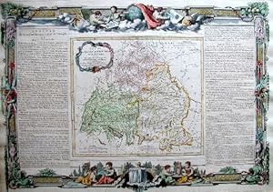
Circles de Bavire, de Franconie et Souabe
Editore: Artist: Brion de la Tour/ Desnos L/ LC ( - 1803 ) France ; issued in: Paris ; dated: 1766; - Louis Brion de la Tour was a french cartographer and demographer With his knowledgebacame the famous « Ingénieur Géographe du Roi »He issued together with Louis Charles Desnos (1750-1790) several atlases and globes, 1743
Da: Antique Sommer& Sapunaru KG, München, Germania
Membro dell'associazione: ILAB VDA
Valutazione venditore:
Technic: Copper print; colorit: black/white; condition: Very good, size (in cm): 37 x 53; - Map of Bavaria, Franken and Schwaben.
