Importo totale (1 articolo articoli):
Destinazione ordine:

brue adrien hubert (76 risultati)
Vai alla pagina principale dei risultati di ricerca
Tipo di articolo
- Tutti gli articoli
- Libri (49)
- Riviste e Giornali
- Fumetti
- Spartiti
- Arte, Stampe e Poster (14)
- Fotografie
- Mappe (13)
-
Manoscritti e
Collezionismo cartaceo
Condizioni
Legatura
Ulteriori caratteristiche
Spedizione gratuita
Paese del venditore
Valutazione venditore
-
![Immagine del venditore per Examen de l'article insere per M. Malte-Brun dans le 19. volume des Nouvelles Annales des Voyages sur l'Atlas universel de geographie et d'histoire ([ca. 1825]) [LeatherBound] venduto da True World of Books](https://pictures.abebooks.com/inventory/md/md31618745424.jpg)
Examen de l'article insere per M. Malte-Brun dans le 19. volume des Nouvelles Annales des Voyages sur l'Atlas universel de geographie et d'histoire ([ca. 1825]) [LeatherBound]
Data di pubblicazione: 2023
Libro Print on Demand
LeatherBound. Condizione: NEW. LeatherBound edition. Condition: New. Reprinted from [ca. 1825] edition. Leather Binding on Spine and Corners with Golden leaf printing on spine. Bound in genuine leather with Satin ribbon page markers and Spine with raised gilt bands. A perfect gift for your loved ones. NO changes have been made to the original text. This is NOT a retyped or an ocr'd reprint. Illustrations, Index, if any, are included in black and white. Each page is checked manually before printing. As this print on demand book is reprinted from a very old book, there could be some missing or flawed pages, but we always try to make the book as complete as possible. Fold-outs, if any, are not part of the book. If the original book was published in multiple volumes then this reprint is of only one volume, not the whole set. Sewing binding for longer life, where the book block is actually sewn (smythe sewn/section sewn) with thread before binding which results in a more durable type of binding. Pages: 25.
-
Examen De L\ article Inséré Per M. Malte-brun Dans Le 19. Volume Des Nouvelles Annales Des Voyages Sur L\ atlas Universel De Géographie Et D\ histoire
Editore: WENTWORTH PR, 2018
ISBN 10: 0274743574ISBN 13: 9780274743575
Libro
Condizione: New.
-
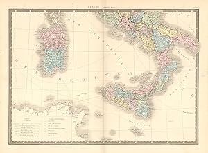
Condizione: Good. 'Italie, partie sud' by A-H Brué. Southern Italy Sicily Sardinia 1875 old map. Antique 19th century engraved atlas map with old colour; Dressée par Adrien-Hubert Brué, Revue par E.Levasseur (1875). 41.0 x 55.5cm, 16 x 21.75 inches; this is a folding map. Condition: Good. There is nothing printed on the reverse side, which is plain. Southern Part of Italy. Sicily. Sardinia.
-
Condizione: Good. 'Italie, partie sud' by A-H Brué. Southern Italy Sicily Sardinia c1842 old map. Antique 19th century engraved atlas map with old colour; Dressée par Adrien-Hubert Brué, Revue par E.Levasseur (c1842). 40.0 x 57.0cm, 15.75 x 22.5 inches; this is a folding map. Condition: Good. Minor offsetting -text and/or images from the facing page have left an impression on the print. There is nothing printed on the reverse side, which is plain. Southern Part of Italy. Sicily. Sardinia.
-
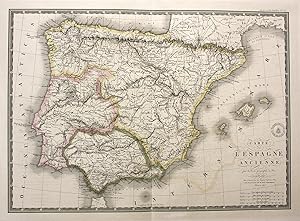
Carte de l'Espagne ancienne" - Espana Spain Spanien Portugal Karte map
Editore: Paris, 1827
Da: Antiquariat Steffen Völkel GmbH, Seubersdorf, Germania
Membro dell'associazione: ILAB VDA
Valutazione venditore:

Mappa
original kolorierte Kupferstich-Karte von 1827 - Blatt-Format: ca. 68,5 x 53,5 cm - Plattenmasse: ca. 55,5 x 40,5 cm - teils leicht fleckig, mit Randeinrissen im Außenrand, sonst gut erhalten. | original colored copper engraved map from 1827 - partly slightly stained, with marginal tears in outer margins, otherwise in good condition. | Original! - Kein Nachdruck! - Keine Kopie! | This is an original! - No reprint! - No copy! Sprache: Deutsch Gewicht in Gramm: 1500.
-
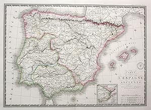
Carte de l'Espagne ancienne" - Espana Spain Spanien Portugal Karte map
Editore: Paris, 1830
Da: Antiquariat Steffen Völkel GmbH, Seubersdorf, Germania
Membro dell'associazione: ILAB VDA
Valutazione venditore:
Mappa
original kolorierte Kupferstich-Karte von ca. 1830 - Blatt-Format: ca. 66 x 52,5 cm - Plattenmasse: ca. 54,5 x 39,5 cm - teils leicht fleckig, mit Randeinrissen im Außenrand, sonst gut erhalten. | original colored copper engraved map from about 1830 - partly slightly stained, with marginal tears in outer margins, otherwise in good condition. | Original! - Kein Nachdruck! - Keine Kopie! | This is an original! - No reprint! - No copy! Sprache: Deutsch Gewicht in Gramm: 1500.
-
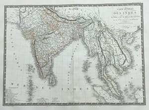
Carte Générale Des Indes en-deca et au-dela du gange
Editore: Paris Institut Geographique de Paris 1821, 1821
Da: Harrison-Hiett Rare Books, Richelieu, Francia
Membro dell'associazione: ABA ILAB NVVA
Valutazione venditore:

Mappa
Engraved & Hand coloured map of India, Korea, Cambodia, Vietnam etc. Published in Atlas Universel De Geographie Physique, Politique, Ancienne Et Moderne. Dimensions: 400 x 545 mm. (on sheet: 490 x 650 mm.) Good. Wide margins. Fold as published. Verso: blank. Contemporary border-colours. Clear impressions. Relief shown by hachures. Railroads. Prime meridian Paris. Six scales. Shows colonies and possessions of European and native powers. 400 x 545 mm (15ľ x 21˝ inches). Carte gravée et coloriée ŕ la main de l'Inde, de la Corée, du Cambodge, du Vietnam, etc. Publiée dans Atlas Universel De Geographie Physique, Politique, Ancienne Et Moderne. Dimensions : 40 x 54,5 cm. (sur feuille : 49 x 65 cm.) Bon. De larges marges. Plier tel que publié. Verso : vierge. Bordure-couleurs contemporaines. Impressions claires. Relief indiqué par des hachures. Chemins de fer. Premier méridien Paris. Six échelles. Affiche les colonies et les possessions des puissances européennes et indigčnes. 400 x 545 mm.
-
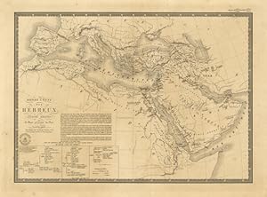
Monde connu des Hebreux
Editore: Asia - Africa
-
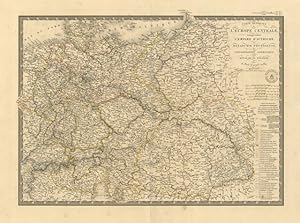
Carte Générale de l'Europe Centrale .
Editore: Europa centrale
Restauro alla piega centrale editoriale.
-

Carte Topographique Des Environs Paris
Editore: E. Andriveau-Goujon, Paris, 1863
Da: Samuel Lasenby Bookseller, Corona del Mar, CA, U.S.A.
Valutazione venditore:
Libro
Cloth. Condizione: Very Good. First Thus. Green boards with tooled design. Gilt title on front and spine. Nouvelle Edition Part of Atlas Universal series. Folding Map Image folds out to 26" x 39" [66 x 99 centimeters] Map very good condtion with some color high lights. 1 3/4" tear spine edge and also 1/2" and 3/4" section. Publisher gilt title on rear board.
-
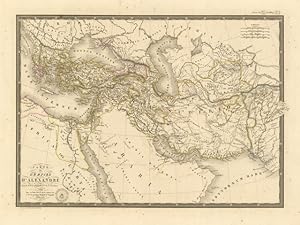
Carte de l'Empire d'Alexandre
Editore: Impero di Alessandro Magno
-
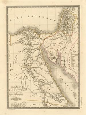
Carte Générale de l'Egypte ancienne, .
Editore: Egitto
-
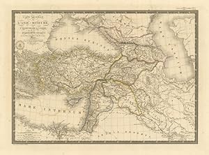
Carte Générale de l'Asie Mineure .
Editore: Asia
-
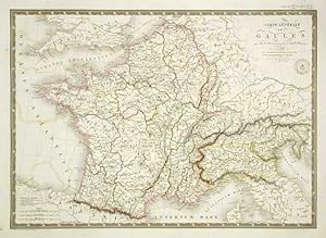
Carte Générale des Gaules
Editore: Francia - Italia
-
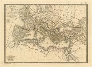
Carte Générale de l'Empire Romain sous Constantin
Editore: Impero Romano
-
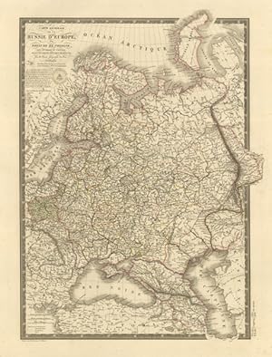
Carte Générale de la Russie d'Europe
Editore: Russia
-
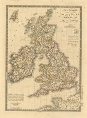
Carte Générale des Iles Britanniques .
Editore: Gran Bretagna
-
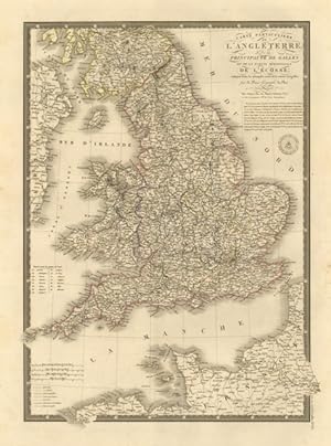
Carte Particuliere de l'Angleterre .
Editore: Inghilterra
-
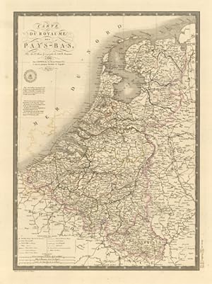
Carte du Royaume des Pays - Bas
Editore: Paesi Bassi
-
Carte de la France en 1789 .
Editore: Francia
-
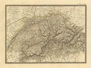
Carte Générale Phisique et Routiere des 22 Cantons de la Confederation Suisse
Editore: Svizzera
-
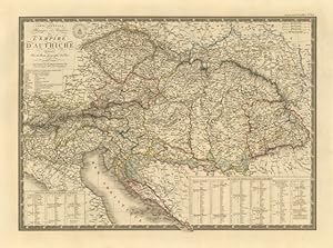
Carte Générale Physique et Routiere de l'Empire d'Autriche
Editore: Impero Austriaco - Austria
-
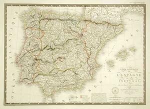
Carte Générale de l'Espagne et du Portugal
Editore: Spagna (Espańa)
-
Carte Générale de l'Asie
Editore: Asia
-
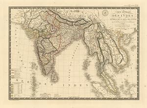
Carte Générale des Indes .
Editore: India
-
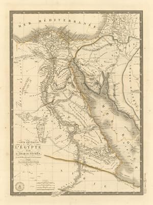
Carte Générale de l'Egypte et de l'Arabie Pétrée
Editore: Egitto
-
Carte Générale de la Monarchie Prussienne
Editore: Prussia
-
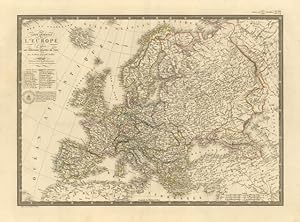
Carte Générale de l'Europe .
Editore: Europa
-
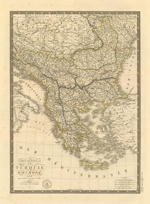
Carte Générale de la Turquie d'Europe
Editore: Penisola Balcanica
-
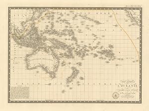
Carte Générale de l'Oceanie .
Editore: Oceania