
Importo totale (1 articolo articoli):
Destinazione ordine:

covens johannes mortier cornelis (10 risultati)
Vai alla pagina principale dei risultati di ricerca
Tipo di articolo
- Tutti gli articoli
- Libri (5)
- Riviste e Giornali
- Fumetti
- Spartiti
- Arte, Stampe e Poster (3)
- Fotografie
- Mappe (2)
-
Manoscritti e
Collezionismo cartaceo
Condizioni
- Tutte
- Nuovi
- Antichi o usati
Legatura
- Tutte
- Rilegato
- Brossura
Ulteriori caratteristiche
- Prima edizione
- Copia autografata
- Sovraccoperta
- Con foto
- No print on demand
Paese del venditore
Valutazione venditore
-
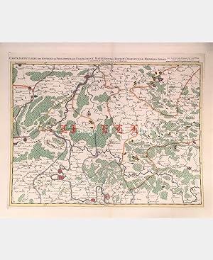
Pas de couverture. Condizione: Trčs bon. Carte particuličre des environs de Philippeville, Charlemont, Marienbourg, Rocroy, Charleville, Mezieres, Sedan. Covens (Johannes), Mortier (Cornelis). Gravure sur cuivre. XVIIIe sičcle. Coloris main. Imprimée ŕ Amsterdam chez Covens et Mortier, d'aprčs la carte de Fricx. Dimension du feuillet : 558 x 662 mm. Dimension au coup de planche : 447 x 568 mm. Pli central. Grandes marges. Trčs belle épreuve.Le prix du port est calculé selon la destination et le poids du colis. Cartes.
-
Condizione: Good. 'Partie Meridionale du Duché de Bourgogne'. COVENS & MORTIER/DE L'ISLE c1730 map. Antique hand coloured eighteenth century copperplate map. Original colour in outline; J. Covens et C. Mortier / Guillaume de l'Isle (c1730). 51.5 x 65.0cm, 20.25 x 25.5 inches; this is a folding map. Condition: Good. Spot; Minor offsetting -text and/or images from the facing page have left an impression on the print. Strong, dark impression with attractive old colour. There is nothing printed on the reverse side, which is plain. A map of the southern part of the Duchy of Burgundy, covering the present day département of Sâone-et-Loire, and the southern part of Côte-d'Or. The map covers the area from Nuits-Saint-Georges, Dole and Beaune in the north, Lons-le-Saunier, Mâcon and Beaujolais in the south, to Marcigny, Bourbon-Lancy and Château-Chinon in the west. Châlon-sur-Saone is marked.
-
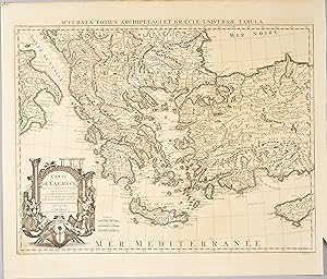
Accurata Totius Archipelagi et Graeciae universae Tabula / Carte de la Grece dressée sur un grand nombre de memoires .
Editore: Amsterdam
Condizione: Trčs bon. Carte uniformement brunie. Petite coupure et décoloration dans le coin inférieur droit.Carte détaillée de la Grčce incluant l'Albanie, la Macédoine, une partie de la Turquie et Chypre // ENGLISH // Map uniformly browned. Small cut and discoloration in the lower right corner.Detailed map of Greece including Albania, Macedonia, part of Turkey and Cyprus.
-
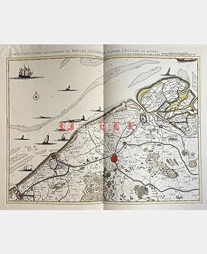
Pas de couverture. Condizione: Trčs bon. Carte particuliere des environs de Bruges, Ostende, Damme, L'Ecluse et autres. Johannes Covens et Cornelis Mortier. Gravure sur cuivre. 1745. Coloris d'époque. Pliure centrale verticale. Dimension du feuillet : 568 x 686 mm. Dimension au coup de planche : 435 x 555 mm. Se vend chez Covens et Mortier ŕ Amsterdam sur la copie de Bruxelles chez Eugčne-Henri Fricx. Trčs belle épreuve.Le prix du port est calculé selon la destination et le poids du colis. Art, Affiches et Gravures.
-
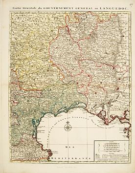
Partie Orientale du Gouvernement General de Languedoc
Editore: Amsterdam. [c.1750], 1750
Da: Peter Harrington. ABA/ ILAB., London, Regno Unito
Membro dell'associazione: ABA ILAB PBFA
Valutazione venditore:

Attractive and detailed map of eastern Languedoc, from Corbieres to the Marseilles and north as far as St Paulhan. title on top border of the map, five scales at lower right. Coloured by region. Copper engraving. Later colouring. Fine condition, good margins, closed tear at lower edge, 1cm strip of paper pasted along edge of right hand margin, not affecting map Size: 46 x 57.5 cm.
-
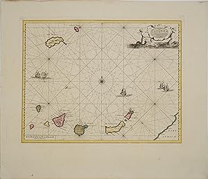
Isles du Cap Verd Hispanis Islas de Cabo Verde Belgis de Soute Eylanden.
Editore: Amsterdam
Condizione: Trčs bon. Carte gravée sur cuivre. Coloris original.L'archipel des Canaries est composé de sept îles principales au Sud (Fuerteventura, Grande Canarie, Tenerife, La Gomera, La Palma et El Hierro). Cinq navires sont représentés sur l'océan Atlantique entre les deux archipels. Nombreux rumbs. Le titre est inscrit dans un élégant cartouche allégorique. // ENGLISH // Engraved card on copper. Original coloring.The archipelago of the Canaries is composed of seven main islands in the South (Fuerteventura, Gran Canaria, Tenerife, La Gomera, La Palma and El Hierro). Five ships are represented on the Atlantic Ocean between the two archipelagos. Numerous rumbs. The title is inscribed in an elegant allegorical cartouche.
-
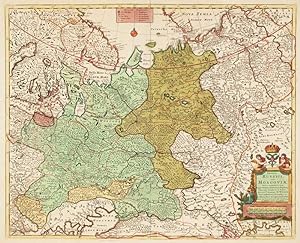
Imperii Russici sive Moscoviae.
Data di pubblicazione: 1730
Da: Altea Antique Maps, London, Regno Unito
Membro dell'associazione: ABA ILAB PBFA
Valutazione venditore:
Mappa
No Binding. Condizione: Good. Amsterdam, c.1730. Original colour. 450 x 560mm. A finely-coloured map of Russia, with a fine title cartouche featuring the Imperial Eagle.
-
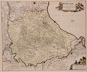
Ducatus Gelriae Tetrarchia Arnhemiensis sive Velavia", kopergravure uitgegeven te Amsterdam ca
Da: Inter-Antiquariaat Mefferdt & De Jonge, Amsterdam, Paesi Bassi
Membro dell'associazione: ILAB NVVA
Valutazione venditore:
Arte / Stampa / Poster
"Ducatus Gelriae Tetrarchia Arnhemiensis sive Velavia", kopergravure uitgegeven te Amsterdam ca. 1720 door Johannes Covens en Cornelis Mortier. In de tijd met de hand gekleurd. Afm. 46 x 56 cm. Het Kwartier van Veluwe, met als hoofdstad Arnhem, omvatte het gebied Veluwe. De voornaamste steden waren toen Elburg, Hattem, Harderwijk en Wageningen. Het kwartier was onderverdeeld in de gebieden Richterambt Veluwezoom, Richterambt Oldebroek, Richterambt Nijbroek en het Landdrostambt Veluwe. Op 5 oktober 1580 stelde het Kwartier van Veluwe een permanent college van Gedeputeerde Staten in. Dat bestond uit twee leden uit de Ridderschap van de Veluwe en één uit de stemhebbende steden. In 1594 werd het aantal leden verhoogd naar vier, in 1599 tot zes. De laatste uitbreiding van het aantal had te maken met het beheer van de geestelijke goederen. De Gedeputeerden bleven in functie tot de uiteindelijke opheffing van de Staten van Gelderland in 1798. Het titelcartouche wordt gedragen door een drietal putti. In het tweede cartouche met de schaal van de kaart zien we nog een putto met het wapen van het hertogdom Gelre en een aantal landmeetinstrumenten. Deze kaart werd eind 17e-eeuw uitgegeven door Frederik de Wit. De koperen plaat waarmee De Wit zijn kaart had gedrukt, werd overgenomen door Covens en Mortier en behalve dat Covens en Mortier er hun naam opzetten, rond 1720 ongewijzigd weer op de markt gebracht. Prijs: Euro 650,-.
-
![Immagine del venditore per 17E-EEUWS LEIDEN "Lugduni Batavorum vulgo Leyden sic ultimo delineato" [ Aftekening van Lugdunum Batavorum, in de volksmond Leiden, na de laatste vergroting] venduto da Inter-Antiquariaat Mefferdt & De Jonge](https://pictures.abebooks.com/inventory/md/md31378418923.jpg)
17E-EEUWS LEIDEN "Lugduni Batavorum vulgo Leyden sic ultimo delineato" [ Aftekening van Lugdunum Batavorum, in de volksmond Leiden, na de laatste vergroting]
Da: Inter-Antiquariaat Mefferdt & De Jonge, Amsterdam, Paesi Bassi
Membro dell'associazione: ILAB NVVA
Valutazione venditore:
Arte / Stampa / Poster
17E-EEUWS LEIDEN "Lugduni Batavorum vulgo Leyden sic ultimo delineato" [ Aftekening van Lugdunum Batavorum, in de volksmond Leiden, na de laatste vergroting]. Kopergravure voor het eerst uitgegeven door Frederick de Wit in 1690, hier in een ongewijzigde heruitgave door Johannes Covens en Cornelis Mortier van rond 1730. Later met de hand geleurd. Afm. 50,5 x 59,5 cm. Leiden, de vierde stad van Holland, was in de zeventiende eeuw een belangrijke stad. Dat kwam vooral door de universiteit die er in 1575 gesticht was. Leiden kreeg die universiteit als dank voor het dappere verzet tegen de Spanjaarden in de Tachtig Jarige Oorlog. De stad is gebouwd rondom de burcht, een kunstmatige kegelvormige heuvel waarop ion de twaalfde eeuw een ronde turfstenen vluchtburcht werd gebouwd. Deze burcht staat op de plaats waar twee Rijnarmen samenkomen, precies midden in de stad. De nederzetting ontwikkelde zich als een dijkdorp van de zuidelijke Rijndijk, de latere Breestraat. Zij werd het middelpunt van handel en scheepvaart in de zich snel ontwikkelende agrarische omgeving. Opmerkelijk is dat Leiden geen grote pleinen of markten heeft. De plattegrond van Leiden is een van de weinige waarvoor Frederick de Wit niet de de oude koperplaten van Blaeu of Janssonius heeft gekopieerd. Hij heeft Leiden laten graveren naar het voorbeeld van de plattegrond van Christian Hagen uit 1675 (de zgn. Kleine Hagen ). De plattegrond is gemaakt na de zesde stadsvergroting van 1659. Aan de rechterkant van de kaart is de nooit gebouwde "Nieuw Gefondeerde kerck" of Waardkerk te zien. Linksonder staat een cartouche met de gebruikte cijfers. Op het cartouche zien we Athena, de godin van de wetenschap, met het wapen van Leiden. Naast haar pronkt Demeter, de godin van de landbouw, met een hoorn des overvloeds. Naast het cartouche staat een kaasmaker. Deze decoratieve elementen heeft De Wit ook van de kaart van Christian Hagen overgenomen. In tegenstelling tot de kaarten die De Wit van Blaeu en Janssonius heeft overgenomen, staat hier het stadswapen dus niet rechtsboven, maar linksonder in de cartouche. Prijs: Euro 1.950,-.
-
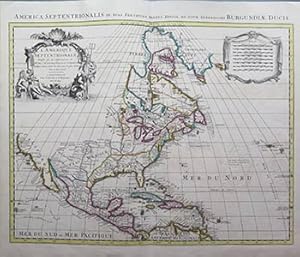
L'Amerique Septentrionale dressee sur les Observations de Mrs. De L'Academie Royale des Sciences & quelques autres?.par. G. De L'Isle. First edition of the map.
Editore: Amsterdam: I. Covens & C. Mortier, c. 1730, 1730
Arte / Stampa / Poster
Condizione: Good. Original handcolored engraved map, on thick laid paper watermarked "MW." Sheet size 52.2 x 62cm. Centerfold. Shows North America from Greenland to Panama and the Antilles. Fine condition.Covens & Mortier edition of one of De L'Isle's most influential (and later copied) maps. . Shows North America with colonial divisions and an uninhabited Northwest. The Southeast is shown as Floride and the Southwest as Nouveau Mexique. The mouth of the Mississippi is pushed considerable west of its true location. A few places noted along the California coast. Quivira placed in the Midwest. The routes of Cortez in 1534, Drake's route, D'Olivier's route in 1600, Gaeten's route in 1542 and Mendana's route are shown off California. Excellen detail throughout. Names the Apaches Peuples, Apaches de navaio and other Indian Tribes. Important early Great Lakes configuration.
![Immagine del venditore per Partie Meridionale du Duché de Bourgogne, Par Guillaume De l'Isle, Premier Geographe du Roy de l'Academie Royale des Sciences. Carte du Duché de Bourgogne et des Comtez en dependans [Southern part of the Duchy of Burgundy by Guillaume de L'Isle, first Geographer to the King, of Royal Academy of Sciences. Map of the Duchy of Burgundy and its counties and dependancies] venduto da Antiqua Print Gallery](https://pictures.abebooks.com/inventory/md/md31102173790.jpg)