
Importo totale (1 articolo articoli):
Destinazione ordine:

r v tooley r a skelton coolie (4 risultati)
Vai alla pagina principale dei risultati di ricerca
Tipo di articolo
- Tutti gli articoli
- Libri (4)
- Riviste e Giornali
- Fumetti
- Spartiti
- Arte, Stampe e Poster
- Fotografie
- Mappe
-
Manoscritti e
Collezionismo cartaceo
Condizioni
Legatura
- Tutte
- Rilegato (2)
- Brossura
Ulteriori caratteristiche
- Prima edizione
- Copia autografata
- Sovraccoperta (2)
- Con foto (1)
- No print on demand
Paese del venditore
Valutazione venditore
-

Lot of 3 Issues of Map Collectors' Circle, No. 33, No. 37, and No. 45
Editore: Map Collectors' Circle
Condizione: Good. Good condition. Lot of 3 Issues of Map Collectors' Circle: Volume 4, No. 33: French Mapping of the Americas; Volume 4, No. 37: The Marine Surveys of James Cook in North America, 1758-1768; and Volume 5, No. 45: Smith's Virginia and its Derivatives. (map, geography, cartography).
-
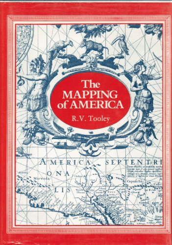
The Mapping of America
Editore: Holland Press, London, 1988
ISBN 10: 0900470917ISBN 13: 9780900470912
Libro
Hardcover. Condizione: Fine condition. Condizione sovraccoperta: Fine dust jacket. Third printing. London: Holland Press, 1988. Fine condition in a Fine dust jacket. NO chips. NO tears. NO creases. NO fading. Bright, shiny, clean, square and tight. Sharp corners. NOT a library discard. NO owner's name or bookplate. NOT a remainder. NO underlining. NO highlighting. NO margin notes. Illustrated with 179 plates, mostly old map reproductions. Includes many descriptive cartobibliographies. Among 11 chapters are CALIFORNIA AS AN ISLAND, COMPARATIVE CARTOGRAPHY, NORTH AMERICAN CITY PLANS, FRENCH MAPPING OF THE AMERICAS, THE MAPPING OF THE GREAT LAKES, MAPS OF THE YORKTOWN CAMPAIGN, MARINE SURVEYS OF JAMES COOK IN NORTH AMERICA, 1758-1768, etc. Some of these studies are new; others are corrected and revised editions of articles that first appeared in MAP COLLECTORS' CIRCLE. In addition to Tooley, contributors include Tony Campbell, R. A. Skelton, Coolie Verner, Roland Tree, etc. Comprehensive index compiled by Douglas Matthews. 7.25" wide by 10" tall. Bound in the original blue cloth, stamped in shiny gold. Complete with dust jacket. Third printing. Hardcover. Fine condition/Fine dust jacket. xii, 519pp. Great Packaging, Fast Shipping.
-
The Mapping of America
Editore: Holland Press, London, 1988
ISBN 10: 0900470917ISBN 13: 9780900470912
Libro
Hardcover. Condizione: New. Condizione sovraccoperta: New. Third printing. London: Holland Press, 1988. A beautiful, pristine copy in PERFECT condition. Brand New in a Brand New dust jacket. NO chips. NO tears. NO creases. NO fading. Bright, shiny, clean, square and tight. Sharp corners. NOT a library discard. NO owner's name or bookplate. NOT a remainder. Pages are fresh and crisp -- obviously never read. NO underlining. NO highlighting. NO margin notes. Illustrated with 179 plates, mostly old map reproductions. Includes many descriptive cartobibliographies. Among 11 chapters are CALIFORNIA AS AN ISLAND, COMPARATIVE CARTOGRAPHY, NORTH AMERICAN CITY PLANS, FRENCH MAPPING OF THE AMERICAS, THE MAPPING OF THE GREAT LAKES, MAPS OF THE YORKTOWN CAMPAIGN, MARINE SURVEYS OF JAMES COOK IN NORTH AMERICA, 1758-1768, etc. Some of these studies are new; others are corrected and revised editions of articles that first appeared in MAP COLLECTORS' CIRCLE. In addition to Tooley, contributors include Tony Campbell, R. A. Skelton, Coolie Verner, Roland Tree, etc. Comprehensive index compiled by Douglas Matthews. 7.25" wide by 10" tall. Bound in the original blue cloth, stamped in shiny gold. Complete with dust jacket. Third printing. Hardcover. New/New. xii, 519pp. Great Packaging, Fast Shipping.
-
Map Collectors Circle: 42 Monographs (out of a series of 110) many dealing with maps related to Australia and the Pacific being numbers; 5, 6, 12, 23, 25, 26, 27, 29, 30, 32, 38, 39, 43, 44, 45, 46, 47, 48, 49, 53, 54, 55, 56, 57, 59, 60, 61, 62, 63, 64, 65, 66, 70, 71, 72, 76, 79, 85, 89, 108, and 109.
Da: Time Booksellers, Somerville, VIC, Australia
Membro dell'associazione: ANZAAB ILAB
Valutazione venditore:

First Editions; Cr. 4to; pp. (an average of 45 pages each); illustrated with numerous maps, bound in original stiff illustrated wrappers, very good copies. The Map Collectors' Circle was founded in London in April 1963 by Ronald Vere Tooley with a stated aim of "stimulating interest in and publishing material on early printed maps, atlases, cartographers etc." Between 1963 and 1975 it set about fulfilling its second mandate with a series of 110 monographs related to the field of historical cartography which remain of great interest to collectors of today.
