Importo totale (1 articolo articoli):
Destinazione ordine:

schenk gerard valk (117 risultati)
Vai alla pagina principale dei risultati di ricerca
Tipo di articolo
- Tutti gli articoli
- Libri (44)
- Riviste e Giornali
- Fumetti
- Spartiti
- Arte, Stampe e Poster (16)
- Fotografie
- Mappe (57)
-
Manoscritti e
Collezionismo cartaceo
Condizioni
- Tutte
- Nuovi
- Antichi o usati
Legatura
- Tutte
- Rilegato (37)
- Brossura
Ulteriori caratteristiche
- Prima edizione
- Copia autografata (1)
- Sovraccoperta
- Con foto (110)
- No print on demand
Paese del venditore
Valutazione venditore
-
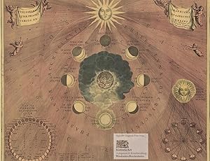
Typus Seleno Lunae Phases Varios ad Graphicus et Aspectus Umbrans. Große und dekorative Himmelskarte der verschiedenen Aspekte der Mondphasen. Reprint eines kolorierten Kupferstichs von Hondius bei Schenk und Valk
Editore: ohne Orts- und Jahresangabe um Nachdruck aus dem "Atlas Coelestis" Amsterdam bei Gerard Valk und Petrus Schenk 1708, 1960
Da: historicArt Antiquariat & Kunsthandlung, Wiesbaden-Breckenheim, Germania
Valutazione venditore:

Mappa
rasterloser Druck von speziell beschichteten Fotoplatten auf Maschinenbütten, Imperialfolio-Blatt ca. 43 x 52 cm, bis an den Rand der bildlichen Darstellung beschnitten, rückseitig alte Montagespuren (wurde ausgerahmt), ansonsten sauber und sehr gut erhalten, auch als Faksimile-Reprint selten großer und/oder schwerer Artikel mit zusätzlichen Kosten für Versand und Versicherung - heavy and/or oversized item with additional costs for shipping and insurance - please ask us before you order this article 2100 gr.
-
Hardcover. Condizione: very good. Kupferkarte, verlegt von P. Schenk, anno 1703, hinter Passepartout montiert, 14x17 und 23x26 cm.
-
![Immagine del venditore per Haemisphaerium sceno graphicum australe coeli stella=ti et terrae. Große Himmelskarte der Tierkreiszeichen des südlichen Nachthimmels [über der unbekannten Erde Australiens] mit Geographen und Astronomen im dekorativen Rand. Reprint eines prächtig kolorierten Kupferstichs von Hondius bei Schenk und Valk venduto da historicArt Antiquariat & Kunsthandlung](https://pictures.abebooks.com/inventory/md/md22020237537.jpg)
Haemisphaerium sceno graphicum australe coeli stella=ti et terrae. Große Himmelskarte der Tierkreiszeichen des südlichen Nachthimmels [über der unbekannten Erde Australiens] mit Geographen und Astronomen im dekorativen Rand. Reprint eines prächtig kolorierten Kupferstichs von Hondius bei Schenk und Valk
Editore: ohne Orts- und Jahresangabe um Nachdruck aus dem "Atlas Coelestis" Amsterdam bei Gerard Valk und Petrus Schenk 1708, 1960
Da: historicArt Antiquariat & Kunsthandlung, Wiesbaden-Breckenheim, Germania
Valutazione venditore:
Mappa
rasterloser Druck von speziell beschichteten Fotoplatten auf Maschinenbütten, Imperialfolio-Blatt ca. 44 x 52 cm, rückseitig kleine Wasserränder ohne Auswirkung auf die tadellos erhaltene Vordereite, insgesamt sauber und sehr gut erhalten, auch als Faksimile-Reprint selten großer und/oder schwerer Artikel mit zusätzlichen Kosten für Versand und Versicherung - heavy and/or oversized item with additional costs for shipping and insurance - please ask us before you order this article 2100 gr.
-
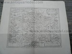
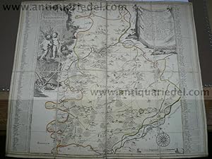
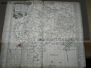
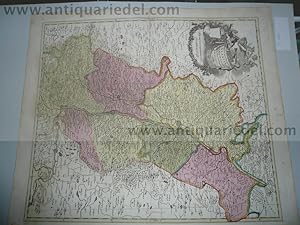
Hardcover. Condizione: very good. Please read german textKupferkarte, verlegt von P. Schenk in "Neuer Sächsischer Atlas", anno 1758, "LOBENSTEIN EBERSDORFF", Blattmaß: 53 x 55 cm., untere Mittelfalz gebräunt, wasserfleckig. Die Karte zeigt die reussischen Herrschafften Lobenstein und Ebersdorf (b.Coburg) mit der sächs. Saale im Zentrum.
-
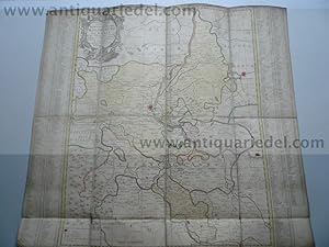
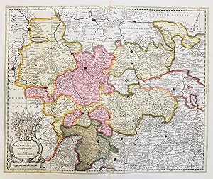
Amt Eckardtsberga, anno 1757, Schenk P., Neuer Sächsischer Atlas
Editore: Schenk P.1660-1718+Valk Gerard, 1718
Hardcover. Condizione: very good. Amt Eckardtsberga, anno 1757, Schenk P., Neuer Sächsischer Atlas, alt in Segmenten auf Leinwand aufgezogen, Blattmaß: 51x61 cm. Mit Erfurt im Südwesten der Karte.
-
Magdeburg/Halle/Wittenberg, anno 1750, Schenk P.
Editore: Schenk P.1660-1718+Valk Gerard, 1718
Mappa
Kein Einband. Condizione: Befriedigend. Kupferkarte, verlegt bei P. Schenk im Neuen Sächsischen Atlas, anno 1750, alt in Segmenten auf Leinwand aufgezogen, 54x58 cm. Mit Wittenberg, Brandenburg, Magdeburg, Halle usw.
-
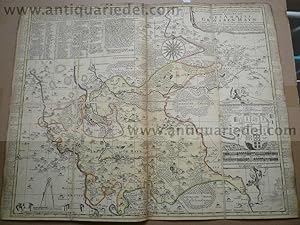
Amt Grossenhayn, anno 1758, Schenk, Neuer sächs. Atlas
Editore: Schenk P.1660-1718+Valk Gerard, 1718
Hardcover. Condizione: very good. Landkarte, verlegt von Schenk anno 1758, im Neuen sächs. Atlas, alt in Segmenten auf Leinwand aufgezogen, Blattmaß: 49x61 cm.
-
Hardcover. Condizione: very good. Amt Wittenberg, Kupferkarte, verlegt von P. Schenk in Neuer Sächsischer Atlas, anno 1758. Die Karte ist in 8 Segmenten auf Leinwand aufgezogen. Blattmaß: 50 x 60 cm., knapp beschnitten, gering gebräunt. Die Lutherstadt Wittenberg befindet sich im Zentrum der Karte, Bitterfeld im Südwesten, Belzig in Brandenburg im Norden.
-
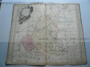
Bitterfeld,Delitzsch,Zoerbig, anno 1758, Schenk, neuer sächs.Atl
Editore: Schenk P.1660-1718+Valk Gerard, 1718
Hardcover. Condizione: very good. Kupferkarte, verlegt bei Schenk in neuer sächs. Atlas, anno 1758, Blattmaß: 51x60 cm., alt in Segmenten auf Leinwand aufgezogen. Die Karte zeigt im Süden Leipzig, im Osten Düben, Eilenburg, im Norden die Elbe mit Wittenberg, im Westen Halle. Im Zentrum der Karte: Delitzsch und Bitterfeld.
-
Abbatia Heresfeldensis vulgo t' Stifftt Hirsfeldt." - Bad Hersfeld Hattenbach Karte map
Editore: Amsterdam, Valk & Schenk um 1700., 1700
Da: Antiquariat Steffen Völkel GmbH, Seubersdorf, Germania
Membro dell'associazione: ILAB VDA
Valutazione venditore:
Mappa
Original altkolorierte Kupferstich-Karte. Seltene Karte. -- Gutes Exemplar in seltenem Original-Verlagskolorit. -- Ohne Rückentext. -- Blatt-Maße: ca. 60 x 50 cm. -- gut erhalten. || Original, rare old colored engraved map. -- In very good condition, with the rare original publishing coloring. Without text on verso. -- in good condition.|| Dies ist ein Original! - Kein Nachdruck! - Keine Kopie! -- This is an original! No copy! - No reprint! la Gewicht in Gramm: 1550.
-
Hardcover. Condizione: very good. Westphalia Ducatus, anno 1700 von Schenk/Valk Schöne Kupferstich Landkarte von Westphalen. Mit zwei schönen Kartuschen. Zeigt die Gegend zwischen Essen, Olpe, Landau und Lippe mit Meschede im Zentrum. Breitrandig, gering gebräunt, minimal randrissig, sauber. Blattmaß: 53x65 cm.
-
Hardcover. Condizione: very good. Kupferkarte, verlegt von P. Schenk, ca. anno 1760, alt in Segmenten auf Leinwand aufgezogen, Blattmaß: 47x62 cm. Die Karte wird begrenzt durch das Amt Zwickau im Osten, Lobenstein im Süden, Saalfeld im Westen und Gerau im Norden.
-
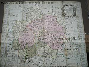
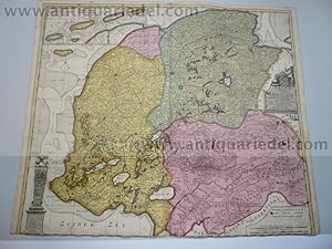
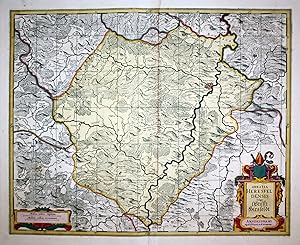
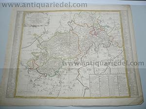
Grafschaft Mansfeld,Chursachsen,anno 1760, P.Schenk, neuer sächs
Editore: Schenk P.1660-1718+Valk Gerard, 1760
Mappa
Kein Einband. Condizione: Gut. P.Schenk: 'Accurate Geographische Delineation der Graffschafft Mannsfelt Sowohl Chur Sächsisch. als Brandenb. Hoheit benebst denen Aemtern Sangerhausen, Querfurth, Sittichenbach, Allstaedt und anderen angrentzenden Gegenden in Amsterdam by P. Schenk mit Königl. und Churfürstl. Sachs. Privilegio. - Zeigt die Grafschaft Mansfeld, das Amt Querfurt, Sittichenbach, Sangerhausen und Allstedt. Oben rechts Titelkartusche. Rechts und links neben der Karte Suchregister. - Unten links Erklärungen. Die Karte ist altkoloriert, alt in Segmenten auf Leinwand aufgezogen, 50x62 cm.
-
Hardcover. Condizione: very good. Orleans,Course of the Loire,anno 1700,map,Valk Coppermap, edited by Valk, anno 1700, the complete course of the loire with Orleans in the center of the map. old, contemporary colours, some brown stains. Size of the map: 51 x 60 cm.
-
Hardcover. Condizione: very good. Please read german text.
-
Hardcover. Condizione: very good. Kupferkarte, verlegt bei Schenk P., in Neuer Sächsischer Atlas, anno 1758, Blattmaß: 49 x 59 cm., sehr guter Erhaltungszustand.
-
Hardcover. Condizione: very good. Bergen op Zoom, anno 1700, Schenk/Valk Tabvla Bergarum ad Zomam Stenbergae. Plan mit Umgebung. Altkolor. Kupferstichkarte v. F. van Schoten bei Valk u. Schenk, Amsterdam um 1700. 22,5 x 52 cm. Mit Inset - Karte "Castra Pinsii" u. 3 Kartuschen. - Breitrandig. Gering gebräunt.
-
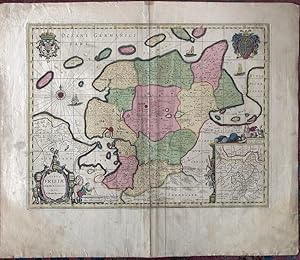
Ducatus Brunsvicensis" - Braunschweig Hildesheim Göttingen Goslar Hameln Einbeck Wolfenbüttel Halberstadt Niedersachsen
Editore: Amsterdam ca. 1700., 1700
Da: Antiquariat Steffen Völkel GmbH, Seubersdorf, Germania
Membro dell'associazione: ILAB VDA
Valutazione venditore:
Mappa
Altkolorierte Kupferstich-Karte von ca. 1700. -- Blatt-Maße: ca. 53 x 61 cm. -- gut erhalten. || Old colored engraved map from ca. 1700. -- in good condition. || Dies ist ein Original! - Kein Nachdruck! - Keine Kopie! -- This is an original! - No copy! - No reprint! la Gewicht in Gramm: 550.
-
Kein Einband. Condizione: Ausreichend. Picardia, map, Valk anno 1700, old colours Coppermap, edited by the Valk family, anno 1700, contemporary old colours, little fingerstained, restored centerfold. Size of the leaf: 51 x 61 cm.
-
Hardcover. Condizione: Gut. Please read german text.Altkolorierte Landkarte von Peter Schenk, zeigt den Rheinlauf bis Philippsburg. Im Westen das Elsass und im Osten Baden. Blattmaß: 62 x 53 cm. Altkoloriert und tadellos erhalten.
-

Ducatus olim Episcopatus Bremensis et ostiorum Albis et Visurgis." - Bremen Bruxelles Stade Hamburg
Editore: Amsterdam ca. 1700., 1700
Da: Antiquariat Steffen Völkel GmbH, Seubersdorf, Germania
Membro dell'associazione: ILAB VDA
Valutazione venditore:
Mappa
Altkolorierte Kupferstich-Karte von ca. 1700. Im Gegensatz zur Janssonius-Ausgabe jetzt mit Fadenkreuz. -- Blatt-Maße: ca. 53 x 61 cm. -- gut erhalten. || Old colored engraved map from ca. 1700. -- in good condition. || Dies ist ein Original! - Kein Nachdruck! - Keine Kopie! -- This is an original! - No copy! - No reprint! la Gewicht in Gramm: 550.
-
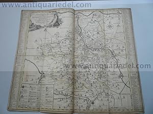
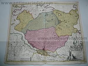
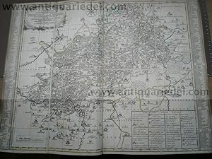
Naumburg/Zeitz, Karte, anno 1750 Schenk P., altkoloriert
Editore: Schenk P.1660-1718+Valk Gerard, 1718
Hardcover. Condizione: very good. Altkolorierte Kupferkarte, verlegt von P. Schenk, anno 1750, alt in Segmenten auf Leinwand aufgezogen, altkoloriert, Blattmaß: 52x56 cm. Für weitere Infos zur Karte bitte unteren Link anklicken.
-
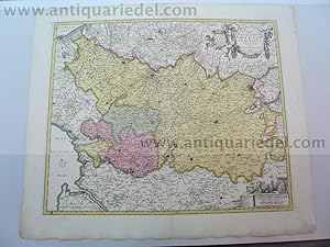
Hardcover. Condizione: very good. 'Accurate Geographische Delineation des Hochf. Sachß. Amtes Weissenfels Nebst allen darzu gehörigen Städten Flecken Dorffschafften wie auch etlichen angraentzenden Orten. Gestochen von Peter Schenk in Amsterdam mit Konigl. und Churfurstl. Sachs. Privilegio.': Altkol. Kupferstich Petrus Schenk in Amsterdam, 1760, alt in Segmenten auf Leinwand aufgezogen, Blattmaß: 50x60 cm. Zeigt das Amt Weißenfels mit dem Gebiet Zeitz, Dothen und Frankleben.
-
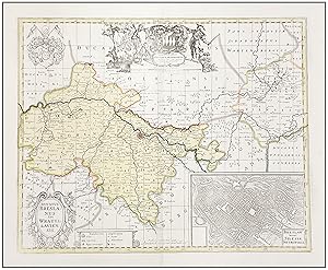
MAPA ANTIGUO DE BRESLAVIA. DUCATUS BRESLANUS SIVE WRATISLAVIENSIS.
Data di pubblicazione: 1700
Da: LIBRERIA ANTICUARIA MARGARITA DE DIOS, MADRID, Spagna
Membro dell'associazione: LANCE
Valutazione venditore:
Mappa
Sin Encuadernar. Condizione: Bien. Materia: Mapa antiguo de principios del siglo XVIII. Grabado. Polonia. Ducado de Breslavia. Autores: Gerard Valk y Peter Schenk. Lugar - Ańo: Ámsterdam, 1700. Dimensiones aprox.: 570 x 670 mm [papel], 400 x 495 mm [huella]. Técnica: Grabado calcográfico en cobre. Impreso en papel grueso y fuerte, de gran calidad. Coloreado a mano con acuarela en la época. Reverso: sin texto. Descripción: Plano de la ciudad de Breslavia (Wroclaw) en la actual Polonia. Cartuchos, escudo de armas de colores y col. Escudo de armas y heraldo un poco descolorido y flanqueado por dos personajes, vegetación y animales, junto con una nueva dedicatoria a G. Cartwright. Vista insertada inferior derecha (aprox. 13 x 19 cm) de Breslavia a vista de pájaro. Cartela decorativa con el título del mapa en la parte inferior izquierda; a su derecha un cartucho con explicaciones de los símbolos del mapa; a la derecha está la dirección de los editores ("prostant amstelaedami apud Petrum Schenk et Gerardum Valk"); y gran escudo de armas en la parte superior izquierda. Este mismo mapa fue diseńado por Janssonius, M. Pitt y S. Swart hacia 1680. Conservación: Buen estado. Color antiguo. Partes ligeramente difuminadas. En la familia Valk, destaca Gerard Valk (1652-1726) fue un editor, grabador, marchante de arte y fabricante de globos terráqueos de Ámsterdam. Fue instruido por Abraham Bloteling y luego se convirtió en su asistente. Los dos se mudaron a Londres, donde Valk trabajó con varios vendedores de mapas e impresos. Se casó con la hermana de Abraham, Maria Bloteling, en Londres alrededor de 1673, donde nació su hijo y sucesor, Leonard, en 1675. Alrededor de 1680 comenzó a trabajar con el grabador alemán Petrus Schenk como grabadores, editores, vendedores de mapas y grabados. Adquirieron las planchas para el Atlas de Janssonius Novus y los mapas de Sanson. Aunque nunca compartieron locales, colaboraron estrechamente en la publicación de ediciones de estas obras. En 1710, el vínculo familiar entre los dos socios, Valk y Schenk, se hizo aún más estrecho cuando el hijo de Gerard, Leonard Valk (1675-1746), se casó con Maria Schenk (1688-1770), la hija de Petrus. Después de la muerte de Gerard en 1726, el negocio continuó en manos de su hijo Leonard y de la viuda de Gerard, María, hasta su muerte en 1729, y luego de Leonard hasta su muerte en 1746. La familia Schenk, por su parte, tiene a Petrus Schenk (1660-1718) como máximo exponente. Nacido lberfeld (Alemania) en 1660 fue el fundador de una de las editoriales más conocidas de Ámsterdam en el siglo XVIII. Siendo alumno del grabador Gerard Valk, se le concedió en 1686 un privilegio a Petrus y Gerard Valk para la fabricación y venta de sus grabados. La contribución de Schenk a la cartografía data de c. 1695. En 1706 se traslada al Vijgendam de Amsterdam, 'en el Atlas de Sanson'. Después de su muerte en 1718, su hijo, Leonardus Schenk, continuó con el taller de arte e impresión. El segundo hijo, Petrus II, se instaló en otra casa famosa: 'en el Atlas de Visscher', donde continuó la asociación con Gerard y Leonarus Valk. La familia Schenk produjo atlas geográficos generales y atlas especiales. Aparte de setenta mapas originales, se conocen varios cientos con el nombre de Schenk, que se imprimieron a partir de planchas obtenidas de Janssonius y Visscher. Schenk y Valk adquirieron todas las placas del Novus Atlas de Janssonius Heir, incluido el atlas celestial. Muchas de las planchas de Janssonius fueron reelaboradas y modificadas. Referencias: Koeman I, 2940:1.3. Este artículo necesita permiso de exportación / This item needs an export permit.
-
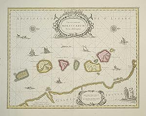
Insularum Moluccarum Nova Descriptio
Editore: France
Condizione: Trčs bon. Bel exemplaire en coloris d'époque d'une carte de l'archipel de St. Lazaro gravée par SCHENK et VALK, ŕ partir de la représentation des « Spice Islands »/ Iles Moluques faite par Jansson. Elle représente les célčbres îles des Moluques : îles aux épices (« Spice Islands ») de l'Empire Hollandais au 17e sičcle. (8 îles : Bachian, Machian, Timor, Pottebackers Eylandt, Tidoro, Miterra, Ternate, Haerij).Des monstres marins sont représentés sur les mers ainsi que des bateaux Européens et locaux indiquant l'importance de cette zone pour les échanges commerciaux. // ENGLISH // Nice copy in period colors of a map of the St. Lazaro archipelago engraved by SCHENK and VALK, based on the representation of the "Spice Islands" made by Jansson. It represents the famous Moluccan islands: Spice Islands of the Dutch Empire in the 17th century (8 islands: Bachian, Machian, Timor, Pottebackers Eylandt, Tidoro, Miterra, Ternate, Haerij).Sea monsters are represented on the seas as well as European and local ships indicating the importance of this area for trade.
-

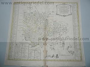
Tarraconensis
Editore: c1690, 1690
Da: Peter Harrington. ABA/ ILAB., London, Regno Unito
Membro dell'associazione: ABA ILAB PBFA
Valutazione venditore:
Two ornamental cartouches, flanked with cherubs, one contains the title, the other the scale, both on top of map. North is to the right of map Copper engraving. Original colour. Very good condition, excellent margins, slight browning along centrefold. Size: 50 x 33.5 cm. (19˝ x 13 inches).
-
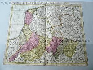
Hardcover. Condizione: very good. Frisiae dominium,Schenk P.,anno 1706, full coloured Coppermap, contemporary full coloured, edited by P.Schenk anno 1706, below margin trimmed, size: 50 x 60 cm. Two restored cracs, not to see in the map.
-
Holsatiae tabula, anno 1707, Schenk, old colours
Editore: Schenk P.1660-1718+Valk Gerard, 1707
Mappa
Kein Einband. Condizione: Gut. Please read german textKupferkarte, verlegt von P. Schenk, zeitgenössisches Flächenkolorit, gedruckt auf dickem Papier, etwas fingerfleckig, untere Mittelfalz hinterlegt. Blattmaß: 51 x 60 cm.
-
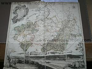
Artesia Tabula, anno 1710 Schenk/Visscher, old colours
Editore: Schenk P.1660-1718+Valk Gerard, 1710
Mappa Copia autografata
Kein Einband. Condizione: Gut. Artesia Tabula, anno 1710 Schenk/Visscher, old colours Coppermap, edited by Petrus Schenk, signed, also Nicolaus Visscher, old colours, some cracs, but only on margins, centerfold ok, size of the leaf: 55x66 cm. Signatur des Verfassers.
-
Typus Frisiae Orientalis. Auctore Ubbone Emmio.
Editore: Amsterdam: Schenk & Valk, [c.1690]., 1690
Da: William Matthews/The Haunted Bookshop, Sidney, BC, Canada
Membro dell'associazione: ABAC ILAB
Valutazione venditore:

A copper engraved map on laid paper, colour cartouche in lower left corner, coloured coats-of-arms in upper corners, entire map coloured. Several coloured sailing ships and a compass rose. Inset map of the mouth of the Amasis River in the lower right corner, with elegant decorations around it. Imprint at bottom: Prostant Amstel apud Petrum Schenk, et Gerardum Valk, C. Priv. Plate size is 49cm x 37.5cm, on a sheet measuring 60cm x 51cm. Verso blank. A few yellowed marks from old tape repairs to verso, "Page 62" in pencil on verso, some wear along central fold, a clean very good copy. A handsome map, nicely coloured. Based on Blaeu's map, first published in his Appendix of 1630.