Importo totale (1 articolo articoli):
Destinazione ordine:

colchester di ordnance survey (120 risultati)
Vai alla pagina principale dei risultati di ricerca
Tipo di articolo
- Tutti gli articoli
- Libri (103)
- Riviste e Giornali
- Fumetti
- Spartiti
- Arte, Stampe e Poster
- Fotografie
- Mappe (17)
-
Manoscritti e
Collezionismo cartaceo
Condizioni
Legatura
Ulteriori caratteristiche
- Prima edizione (5)
- Copia autografata
- Sovraccoperta
- Con foto (40)
- No print on demand
Paese del venditore
Valutazione venditore
-
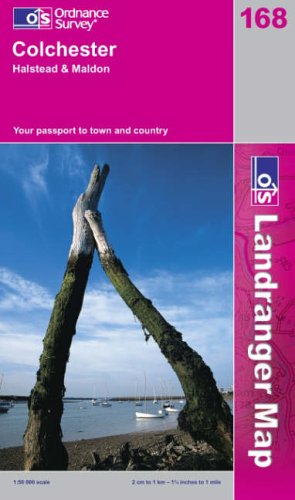
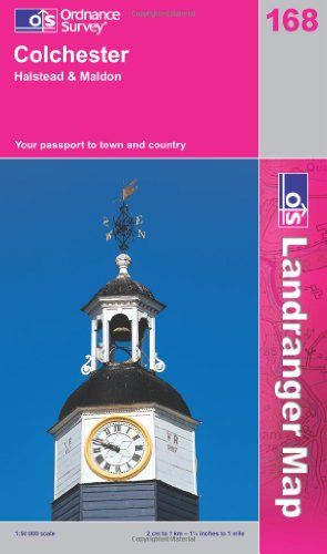
Landranger Maps: Colchester and the Blackwater Area Sheet 168 (OS Landranger Map)
Editore: Ordnance Survey
ISBN 10: 0319221687ISBN 13: 9780319221686
Libro
Paperback. Condizione: Very Good. The book has been read, but is in excellent condition. Pages are intact and not marred by notes or highlighting. The spine remains undamaged.
Ulteriori offerte da altri venditori AbeBooks
Usato - A partire da EUR 1,74
-
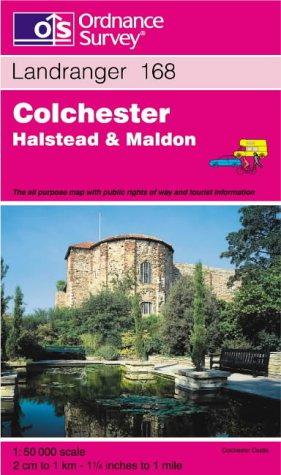
Colchester, Halstead and Maldon: Sheet 168 (Landranger Maps)
Editore: Ordnance Survey, 2002
ISBN 10: 0319227685ISBN 13: 9780319227688
Libro
Paperback. Condizione: Very Good. The book has been read, but is in excellent condition. Pages are intact and not marred by notes or highlighting. The spine remains undamaged.
Ulteriori offerte da altri venditori AbeBooks
Usato - A partire da EUR 2,46
-
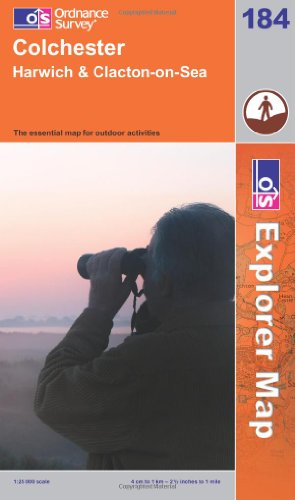
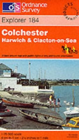
Colchester (Explorer Maps): Sheet 184 (OS Explorer Map)
Editore: Ordnance Survey, 2006
ISBN 10: 0319237826ISBN 13: 9780319237823
Libro
Paperback. Condizione: Good. The book has been read but remains in clean condition. All pages are intact and the cover is intact. Some minor wear to the spine.
Ulteriori offerte da altri venditori AbeBooks
Usato - A partire da EUR 2,66
-
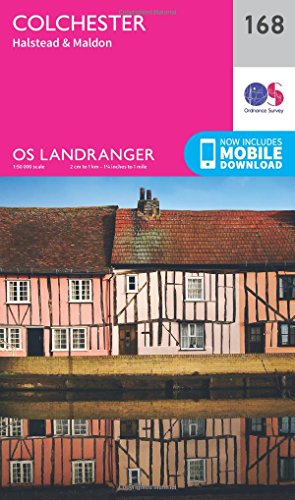
Colchester, Halstead and Maldon (Landranger Maps): Sheet 168 (OS Landranger Map)
Editore: Ordnance Survey, 2006
ISBN 10: 031922922XISBN 13: 9780319229224
Libro
Paperback. Condizione: Very Good. The book has been read, but is in excellent condition. Pages are intact and not marred by notes or highlighting. The spine remains undamaged.
Ulteriori offerte da altri venditori AbeBooks
Nuovo - A partire da EUR 28,17
Usato - A partire da EUR 3,35
Scopri anche Brossura
-
Colchester Map | Halstead & Malton | Ordnance Survey | OS Landranger Map 168 | England | Walks | Cycling | Days Out | Maps | Adventure
Editore: ORDNANCE SURVEY
ISBN 10: 0319262669ISBN 13: 9780319262665
Libro
Paperback. Condizione: Very Good. The book has been read, but is in excellent condition. Pages are intact and not marred by notes or highlighting. The spine remains undamaged.
Ulteriori offerte da altri venditori AbeBooks
Nuovo - A partire da EUR 16,02
Usato - A partire da EUR 4,90
Scopri anche Brossura
-
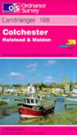
Colchester, Halstead and Maldon (Sheet 168) (OS Landranger Map)
ISBN 10: 0319222756ISBN 13: 9780319222751
Libro
Paperback. Condizione: Good. The book has been read but remains in clean condition. All pages are intact and the cover is intact. Some minor wear to the spine.
Ulteriori offerte da altri venditori AbeBooks
Usato - A partire da EUR 5,74
-
Colchester, Halstead and Maldon (Landranger Maps)
Editore: Ordnance Survey
ISBN 10: 031922385XISBN 13: 9780319223857
Libro
Condizione: Good. Most items will be dispatched the same or the next working day.
-
Colchester: Sheet 184 (Explorer Maps)
Editore: Ordnance Survey, 1725
ISBN 10: 0319218082ISBN 13: 9780319218082
Libro
Paperback. Condizione: Very Good. The book has been read, but is in excellent condition. Pages are intact and not marred by notes or highlighting. The spine remains undamaged.
Ulteriori offerte da altri venditori AbeBooks
Usato - A partire da EUR 8,45
-
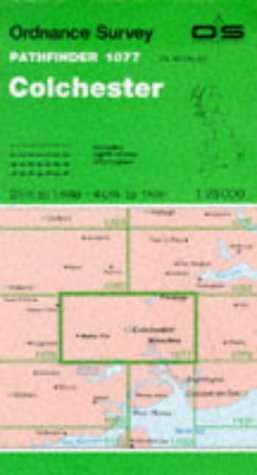
Pathfinder Maps: Colchester Sheet 1077 (TL92/TM02)
Editore: Ordnance Survey
ISBN 10: 0319210774ISBN 13: 9780319210772
Libro
Paperback. Condizione: Very Good. The book has been read, but is in excellent condition. Pages are intact and not marred by notes or highlighting. The spine remains undamaged.
Ulteriori offerte da altri venditori AbeBooks
Usato - A partire da EUR 10,41
-
Condizione: As New. Unread book in perfect condition.
Ulteriori offerte da altri venditori AbeBooks
Nuovo - A partire da EUR 15,55
Usato - A partire da EUR 15,52
Scopri anche Brossura
-
Colchester, Halstead & Maldon
Editore: Ordnance Survey, 2016
ISBN 10: 0319474917ISBN 13: 9780319474914
Libro
Condizione: As New. Unread book in perfect condition.
Ulteriori offerte da altri venditori AbeBooks
Nuovo - A partire da EUR 21,09
Usato - A partire da EUR 17,59
-
Condizione: As New. Unread book in perfect condition.
Ulteriori offerte da altri venditori AbeBooks
Nuovo - A partire da EUR 19,86
Usato - A partire da EUR 17,59
Scopri anche Brossura
-

Paper Wrappers. Condizione: Fine. re-issue. A very good copy of this reprint of the second edition 1896 map of Colchester, Essex at a scale of 1:4340. Sheet Essex XXVII 12. 42 x 59 cms. Size: 8vo.
-
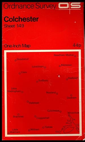
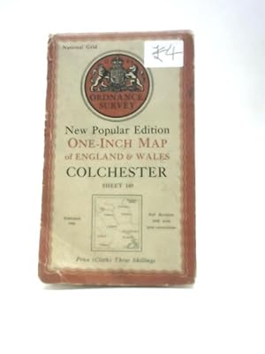
Ordnance Survey Map: COLCHESTER: One Inch Map, Sheet No.149 1969
Editore: Ordnance Survey, Ordnance Survey, Southampton, England, 1969
Mappa
Soft cover. Condizione: Very Good. No Jacket. ## Ordnance Survey Map: COLCHESTER: One Inch Map, Sheet No.149 1969 ## ## Please note: The map's condition, not its cover, determines its categorisation. All maps are pre-owned and may show signs of wear if folded incorrectly. The images displayed on our site are of our actual maps in stock, not generic ones. They are allowing you to assess the condition of the cover before purchase. While the cover may exhibit various degrees of creasing, wear and tear, or damage, the maps are generally in good condition and categorised accordingly. Please refer to the provided images for more details.## ## THIS MAP: Categorised as VERY GOOD. The 1969 edition was published first in 1967. Major roads were updated in 1969. The paper slipcover has general wear and tear, proportional to its age. The detailing of these early maps is remarkable. PLEASE READ ON for interesting information and details. SEE THE IMAGES. ### ## Ordnance Survey (O.S.) is the national mapping agency of Great Britain, producing detailed and accurate maps for various purposes. Its origins date back to the 18th century as a military project to survey the Scottish Highlands and the southern coasts of England in response to the Jacobite rebellion and the French Revolution. The name Ordnance Survey reflects its connection to the Board of Ordnance, the defence ministry of the time.## ## One of the pioneers of O.S. was William Roy, a young engineer who conducted the first small-scale survey of Scotland from 1747 to 1755, using simple instruments such as compasses and chains. He later undertook a more ambitious project to geodetically connect the Royal Observatories of Greenwich and Paris, using a sophisticated theodolite made by Jesse Ramsden. This project, which started in 1784 and lasted until 1790, laid the foundation for the trigonometrical survey of Britain, which aimed to create a network of accurately measured triangles across the country.## ## The trigonometrical survey, also known as the Principal Triangulation, was officially initiated in 1791, marking the birth of O.S. It involved measuring baselines on flat ground, such as Hounslow Heath, and then extending the triangles to hills and mountains, where observatories were built to house the theodolites. The surveyors had to deal with various challenges like weather, terrain, visibility, and accuracy. The survey was completed in 1853, covering over 300,000 square kilometres and 5,000 stations.## ## The trigonometrical survey provided the basis for the first accurate map of Britain, which was published by O.S. in 1801. It was a one-inch-to-the-mile map of Kent, showing roads, rivers, hills, settlements, and land cover. It was followed by maps of other counties and regions, using different scales and symbols. O.S. also produced maps of overseas British colonies, such as India, Africa, and the Caribbean, under the Directorate of Colonial Surveys and the Directorate of Overseas Surveys.## ##Over the years, O.S. has evolved and adapted to the changing needs and technologies of mapping. It has introduced new methods and standards of surveying, such as levelling, photogrammetry, aerial photography, and satellite positioning. It has diversified its products and services, such as digital mapping, online platforms, mobile apps, and geospatial data. Today, O.S. is one of the world's leading mapping agencies, aiming to provide the most up-to-date and comprehensive geospatial information about Great Britain.## ### INTERNATIONAL BUYERS: Please Note. FREE SHIPPING IS FOR THE UK ONLY. Please get in touch with me for a shipping quotation. ####.
-
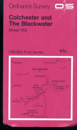
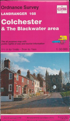
Colchester and The Blackwater 1:50000 First series Sheet 168
Editore: Ordnance Survey, Southampton, 1974
Mappa
Soft cover. Condizione: Very Good. Colchester and The Blackwater 1:50000 First series Sheet 168, 1974 edition. Minimal wear, a crisp and clean copy.
-
One Inch Map: Colchester: Sheet 149
Editore: Ordnance Survey, 1946
Da: World of Rare Books, Goring-by-Sea, SXW, Regno Unito
Valutazione venditore:

Condizione: Fair. 1946. No Edition Remarks. Unpaginated. Colour cloth bound map with pictorial paper covers. Map is lightly tanned overall. Paper cover has moderate edgewear with small tears and creasing. Sticker to front cover. Water stain to front cover. Light tanning overall.
-
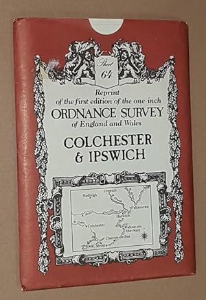
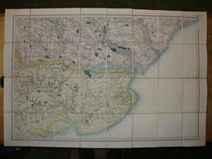
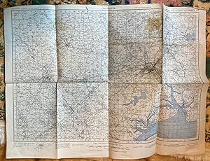
Colchester & Ipswich, Sheet No. 64 Reprint of the first edition of the one-inch Ordnance Survey of England and Wales
Editore: David & Charles, Newton Abbot, 1980
ISBN 10: 0715346121ISBN 13: 9780715346129
Mappa
Map. Condizione: Very Good. Folded map in very good condition, in a shelfworn sleeve.
-
Book of Reference to the Plan of the Parish of St. James, (Liberty of Colchester) in the County of Essex, Containing 238.299 Acres.
Editore: London: HMSO, 1877
Da: David Ford Books PBFA, Cley-next-the-Sea, Regno Unito
Membro dell'associazione: PBFA
Valutazione venditore:
Mappa Prima edizione
Condizione: Good. Presumed First edition. Paperback: grey paper wrappers, lettered in black, thread-bound. Index to the Sheets with plan (folding), and 5pp text : Explanatory remarks, Tables, Index to land usage and places. (ie this is not a map as such but an index and guide to the map). Good: light age toning to wrapper with tears to spine; foxing to pages.
-
Book of Reference to the Plan of the Parish of St.Giles, (Liberty of Colchester) in the County of Essex, Containing 1501.611 Acres.
Editore: London: HMSO, 1877
Da: David Ford Books PBFA, Cley-next-the-Sea, Regno Unito
Membro dell'associazione: PBFA
Valutazione venditore:
Mappa Prima edizione
Condizione: Good. Presumed First edition. Paperback: grey paper wrappers, lettered in black, thread-bound. Index to the Sheets with plan (folding), and 5pp text : Explanatory remarks, Tables, Index to land use and places. (ie this is not a map as such but an index and guide to the map). Good+: some age toning to wrapper with tears to spine ends; clean pages aprt from stain/mark to margin.
-
Book of Reference to the Plan of the Parish of Berechurch, (Liberty of Colchester) in the County of Essex, Containing 1377.429 Acres.
Editore: London: HMSO, 1877
Da: David Ford Books PBFA, Cley-next-the-Sea, Regno Unito
Membro dell'associazione: PBFA
Valutazione venditore:
Mappa Prima edizione
Condizione: Good. Presumed First edition. Paperback: grey paper wrappers, lettered in black, thread-bound. Index to the Sheets with plan (folding), and 5pp text : Explanatory remarks, Tables, Index to land use and places. (ie this is not a map as such but an index and guide to the map). Very Good: light handling ware to wrapper ; a few foxing spots to pages.
-
Book of Reference to the Plan of the Parish of Holy Trinity, (Liberty of Colchester) in the County of Essex, Containing 101.711 Acres.
Editore: London: HMSO, 1877
Da: David Ford Books PBFA, Cley-next-the-Sea, Regno Unito
Membro dell'associazione: PBFA
Valutazione venditore:
Mappa Prima edizione
Condizione: Very Good. Presumed First edition. Paperback: grey paper wrappers, lettered in black, thread-bound. Index to the Sheets with plan (folding), and 5pp text : Explanatory remarks, Tables, Index to land use and places. (ie this is not a map as such but an index and guide to the map). Very Good: some age toning to wrapper with tears to spine ends and creased corner; clean pages.
-
Ordnance Survey Contoured Road Map One inch to One Mile Popular Edition Sheet 97 Colchester
Editore: Ordnance Survey, Southampton, 1921
Libro
Soft cover. Condizione: Good ++. Coloured cloth map.
-
No Binding. Condizione: Good. No Jacket. 5th or later Edition. A good copy of this single sheet (97), paper, colour, OS map, described as Second War Revision, 1940, 5th Edition Style and publication dated 1941. In good condition for its age; outside folds show the occasional mark and one 2" square stain but really very clean; folded out map clean and bright apart from stain as above over Boxted and darkening along some folds, little or no sign of wear. All folds intact, no damage. 75cm x 55cm.
-
![Immagine del venditore per Ordnance Survey Map of Colchester and District. Coloured Edition. One Inch, Sheet 99. [Ellis Martin cover]. venduto da Island Books](https://pictures.abebooks.com/inventory/md/md15483931726.jpg)
Ordnance Survey Map of Colchester and District. Coloured Edition. One Inch, Sheet 99. [Ellis Martin cover].
Editore: Ordnance Survey, [Southampton,, 1914
Mappa
Folding coloured map on cloth measuring 21.x 28.5 ins (approx. 53.0 x 72.0 cms) folding in 24 panels to 7.0 x 3.5 ins (approx. 18.0 x 9.0 cms); original pictorial card wrappers covers lightly browned else a very good bright clean copy. The One Inch Coloured Edition dates from 1904. The present copy is the 1914 reissue; the covers are Ellis Martin's Royal Arms with mantling, dark red and brown variant. Browne, 10.2. SCARCE.
-
Ordnance Survey of England and Wales. Part of Essex - No. 48 Colchester
Editore: Published by Edward Stanford, London, 1868
, hand coloured linen backed Colonel Colby panel map in slipcase Early Reprint , the map has a damp mark to cloth at rear which does not show on any of the panels, in very good condition , the slipcase is faded at edges, and has a 1.5cm crack at the upper head corner and a 0.5cm crack at the lower head corner, very good condition , red cloth covered slipcase, yellow title paper with black lettering tipped to upper , 17.5cm x 13.5cm (folded), 69 x 102 cm (open) Map ISBN:
-
![Immagine del venditore per Ordnance Survey sheet 48 [Manningtree, Hadleigh, Ipswich, Harwich, Felixstow, Shottisham, Boyton, Colchester, and the Colne Estuary, Walton-on-the-Naze, Kirby, Walton-le-Soken - Northern Thames Basin, Suffolk Coast and Heaths, Greater Thames Estuary, South Suffolk and North Essex Clayland] venduto da Antiqua Print Gallery](https://pictures.abebooks.com/inventory/md/md31583238485.jpg)
Ordnance Survey sheet 48 [Manningtree, Hadleigh, Ipswich, Harwich, Felixstow, Shottisham, Boyton, Colchester, and the Colne Estuary, Walton-on-the-Naze, Kirby, Walton-le-Soken - Northern Thames Basin, Suffolk Coast and Heaths, Greater Thames Estuary, South Suffolk and North Essex Clayland]
Data di pubblicazione: 1838
Mappa
Condizione: Good. OS #48 Essex & Suffolk Coast & rivers. Ipswich Colchester Stour Orwell 1838 map. Antique folding hand coloured survey map, dissected and laid down on linen; Engraved at the Ordnance Map Office, Tower of London. Outline by J. Adkins. Writing by J. Adkins. Hills by L. D'Elboux. Published by Thomas Frederick Colby. (1838). 65.5 x 98.0cm, 25.75 x 38.5 inches; this is a folding map. Condition: Good. There is nothing printed on the reverse side, which is plain. The genesis of the Ordnance Survey's original one-inch per mile survey occurred in 1783 when the Royal Societies of Paris and London agreed to connect their two great cities by the use of triangulation to settle the dispute of their relative positions. This triangulation, completed by 1790, together with the outbreak of war with France in 1793, acted as a catalyst for the surveying of England. The survey began in Kent and by the end of the Napoleonic Wars in 1815 most of southern England had been mapped. By 1844, publication of the Old Series, one inch to one mile, was complete for the whole of Great Britain south of Preston and Hull. In spite of concerns about the cost of the survey, work continued until by 1870 the whole of England and Wales had been mapped.