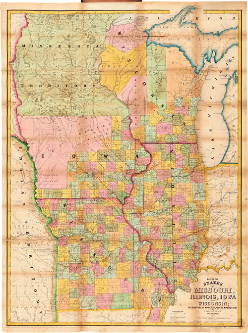

MAP OF THE STATES OF MISSOURI, ILLINOIS, IOWA, AND WISCONSIN: THE TERRITORY OF MINNESOTA, AND THE MINERAL LANDS OF LAKE SUPERIOR
[Drake, I.S.]
Editore: Thomas Cowperthwait, Philadelphia, 1849
Usato
Da
William Reese Company - Americana, New York, NY, U.S.A.
Valutazione del venditore 3 su 5 stelle
![]()
Venditore AbeBooks dal 13 luglio 2006
Questa copia non � pi� disponibile. Ecco le corrispondenze migliori per MAP OF THE STATES OF MISSOURI, ILLINOIS, IOWA, AND WISCONSIN: THE TERRITORY OF MINNESOTA, AND THE MINERAL LANDS OF LAKE SUPERIOR di [Drake, I.S.].
Riguardo questo articolo
Descrizione:
21 1/2 x 29 inches, folded into 12mo. contemporary cloth folder, gilt-lettered cover. Covers slightly rubbed. Two minor tears in from left edge along folds, one three-inch tear also in from left edge; additional small separations at intersections. Occasional faint soiling. Printed color bright and clean. Overall very good. An important pocket map reflecting the growth of the upper Plains economy. Drawn and engraved by I.S. Drake with the assistance of J.J. Hazzard, the map shows a well settled Missouri and Illinois, bordered by less populated Iowa and Wisconsin. Of particular interest are the northern reaches of Wisconsin and the southern portion of Minnesota, then on the brink of a population explosion commiserate with the growth of the timber and taconite industries along the upper Mississippi. Scarce. Not in Rumsey. OCLC locates only four copies. PHILLIPS, MAPS, p.443. OCLC 15175222, 21771126. Codice articolo WRCAM32275
Dati bibliografici
Titolo: MAP OF THE STATES OF MISSOURI, ILLINOIS, ...
Casa editrice: Thomas Cowperthwait, Philadelphia
Data di pubblicazione: 1849
I migliori risultati di ricerca su AbeBooks

MAP OF THE STATES OF MISSOURI, ILLINOIS, IOWA AND WISCONSIN: THE TERRITORY OF MINNESOTA, AND THE MINERAL LANDS OF LAKE SUPERIOR
Editore:
Thomas, Cowperthwait & Co., Philadelphia, 1850
Antico o usato
Rilegato
Da: Live Oak Booksellers, Langley, WA, U.S.A.
Valutazione del venditore 4 su 5 stelle
![]()
Hardcover. Condizione: Very Good. Ira S. Drake and J.L. [John L.] Hazzard (engravers) (illustratore). Copyright 1849 with printed date on map of 1850. 72 X 51 cm. Map in color printed one side that folds into a leather case 9 X 14 cm. Maroon leather with stamped vine design around the outer edges of the covers and the title in gilt on the front cover. Map compiled and drawn by Ira S. Drake and engraved by Ira S. Drake with the help of John L. Hazzard. Map shows counties, state capitols, towns, railroads, stage routes, common roads, canals, rivers and creeks, lakes, and Native American Lands in the "Indian Territory." "Entered according to act of Congress in the year 1849 by Thomas Cowperthwait & Co. in the Clerks Office of the District Court of the Eastern District of Pennsylvania." Map found separated from its leather folder but now archivally repaired and reattached. A couple of minor separations starting at folds, ink spots on obverse of two panels, else very good to near fine with no markings. Leather folder rubbed around the edges with some scuff marks on the exteriors of the covers but with gilt still bright. This is a rare piece of Americana and cartography. Codice articolo 008339
Quantit�: 1 disponibili