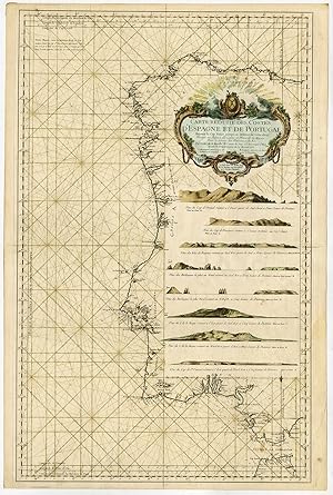
Rare Antique map-PORTUGAL-SPAIN-COASTAL-SEA CHART-Bellin-1751
Venduto da Pictura Prints, Art & Books, Overasselt, Paesi Bassi
Membro dell'associazione:
Venditore AbeBooks dal 1 novembre 2019
Usato
Quantità: 1 disponibili
Aggiungere al carrelloVenduto da Pictura Prints, Art & Books, Overasselt, Paesi Bassi
Membro dell'associazione:
Venditore AbeBooks dal 1 novembre 2019
Quantità: 1 disponibili
Aggiungere al carrelloHand coloured engraving on handlaid (verge type) paper. on paper. Size in cm: The overall size is ca. 91 x 60.5 cm. The image size is ca. 88.5 x 55.5 cm. Size in inch: The overall size is ca. 35.8 x 23.8 inch. The image size is ca. 34.8 x 21.9 inch.Antique map, titled: 'Carte reduite des costes d'Espagne et de Portugal depuis le Cap Pinas jusqu'au Detroit de Gibraltar [.]' - (Detailed map of the coasts of Spain and Portugal from Cape Pinas to the Strait of Gibraltar.) Highly decorative sea chart / nautical map / maritime map of the region centered on Portugal with parts of N-W Spain. With 8 coastal profiles below the large decorative cartouche. Printed stipple rhumb lines are drawn over by hand (!) in a greenish colour, with additional lines added. Remains of manuscript annotations are present. A superb and extremely rare example of this chart with handdrawn lines, most certainly used at sea. First published in Paris in 1751 as part of 'Le Neptune Francois ou Recueil des Cartes Marines', published by Departement de la Marine. State: Most probably an early ed. of this map, still lacking the seal of the Depot de la Marine.Artists and Engravers: Made by an anonymous engraver after 'Jacques Nicolas Bellin'. Cartographer: Jacques-Nicolas Bellin (1703-1772) was a French hydrographer and geographer. He is considered the greatest 18 th. c. French hydrographer and for 50 years he was associated with the 'Depot des cartes et Plans' (Depot de la Marine) as the First hydrographer of the French Royal Navy. His maps were constantly updated with the latest information and their execution magnificent. Bellin's major works are the 'Neptune Francois .', the 'Petit Atlas Maritime .' and the 'Hydrographie Francoise .' As a member of a French intellectual group called the 'Philosophes' and he contributed 994 articles to the 'Encyclopedie' by Diderot/d'Alembert. He also contributed to the 'Histoire Generale des Voyages' by Prevost.Condition: Very good, given age. Hand colouring of a later date. Original middle fold as issued. Slight paper separation at top and lower margins, reinforced and backed. A few small tears in paper edges, backed. A few tiny scattered worm holes at top. Some light staining / soiling. Some creasing. General age-related toning and/or occasional minor defects from handling. Please study scan carefully.Keywords: RARE ANTIQUE MAP-PORTUGAL-SPAIN-COASTAL-SEA CHART-BELLIN(PCO) ZH-430.
Codice articolo cb3804
Visita la pagina della libreria
Pictura Prints guarantees the items to be as described. We always add scans or photographs to our listings. Further information is possibly available on request. Certificates of autenticity (COA) can be provided on request. We use a margin tax treatment.
We ship worldwide and package our items meticulously. We carry an umbrella insurance policy. Our shipment rates are based on shipments up to 1 kg. For heavier shipments we will contact you with a quote. Currently our surcharge for international shipments over 1 kg is 9,14 euro / kg. In addition POST NL temporarly charges 3,60 euro per kg due to CORONA related logistics. We ship by registered mail through POST NL. Expedited shipping or shipment through another carrier is available on request at a possible surcharge.