Fori Iulii Accurata Descriptio.
ORTELIO, ABRAMO.
Data di pubblicazione: 1570
Usato
No legatura
Da
BOTTEGHINA D'ARTE GALLERIA K�PROS, Rosignano Solvay, LI, Italia
Valutazione del venditore 4 su 5 stelle
![]()
Venditore AbeBooks dal 23 maggio 2016
Questa copia non � pi� disponibile. Ecco le corrispondenze migliori per Fori Iulii Accurata Descriptio..
Riguardo questo articolo
Descrizione:
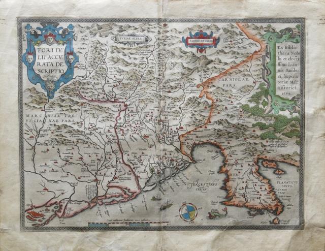
Dal "Theatrum Orbis Terrarum", Anversa, 1570 circa. Incisione in rame, colore, cm 36 x 48 (alla lastra) pi� margini, testo latino al verso, in un cartiglio in alto a destra "Ex Bibliotheca Nobilis et doctissimi Ioannis Sambuci, Imperatoriae Mat.s. Historici 1573". Esemplare con difetti ai margini e alcune gualciture, peraltro a pieni margini e in bella coloritura. Codice articolo 3277
Dati bibliografici
Titolo: Fori Iulii Accurata Descriptio.
Data di pubblicazione: 1570
Legatura: No legatura
Condizione: buono
I migliori risultati di ricerca su AbeBooks
Fori Iulii Accurata Descriptio
Editore:
Ortelius, Abarham, Antwerp, 1592
Antico o usato
Da: Antikvariat Krenek, Prag, Repubblica Ceca
Valutazione del venditore 3 su 5 stelle
![]()
Friuli. "Fori Iulii Accurata Descriptio". Orig. copperplate engraving after J. Sambucus 1573 map. Published by A. Ortelius in Antwerp, 1592. Orig. old colouring. With ornamental title cartouche, another 3 ornament. cartouches, a sea creature, scale of map, wind rose and the city of Venice in lower left corner. 36:48 cm (14 1/4 x 19 inch.). V. d. Broecke 119; Koeman III, map 7171:31B, ed. 31:041 (1592 Latin). - A very decorative map of Friuli with depiction of the Alps at the top and Istria peninsula on the right. Based upon a manuscript map by Johannes Sambucus sent to Ortelius, shortly before 1573, itself based on an anonymous Venetian map of Friuli, from the 1560's. Codice articolo 24363
Quantit�: 1 disponibili

Immagini fornite dal venditore
Fori Iulii Accurata Descriptio; (An Accurate description of Friuli)
Editore:
Abraham Ortelius, Antwerp, 1603
Antico o usato
Da: Argosy Book Store, ABAA, ILAB, New York, NY, U.S.A.
Valutazione del venditore 5 su 5 stelle
![]()
unbound. Map. Engraving with hand coloring. Image measures 14" x 18 3/4". Staining, toning and chips to margins, but otherwise is good condition. Friuli is the northeast Italian region bordering Austria, Slovenia and the Adriatic Sea. It's home to the sharp-peaked Dolomite Mountains and vineyards producing white wines. Ortelius' 1603 edition extends from Venice north to the Italian Alps and east to Trieste and Istria. Lovely depiction of Venice floating on several islands. Abraham Ortelius (1527--1598), a Flemish cartographer and geographer, is widely regarded as one of the important and influential cartographers in history. He is known for his "Theatrum Orbis Terrarum," which was the first modern atlas. Van Den Broecke 119. Codice articolo 299083
Quantit�: 1 disponibili
Fori Iulii Accurata Descriptio
Editore:
Friuli
Antico o usato
Da: Sergio Trippini, Gavirate, VA, Italia
Valutazione del venditore 4 su 5 stelle
![]()
Restauro alla piega centrale. Bella coloritura coeva. Edizione con testo in latino e numero di pagina 79. Codice articolo ST46252
Quantit�: 1 disponibili
Immagini fornite dal venditore
Kupferstich- Karte, n. J. Sambucus b. A. Ortelius, "Fori Iulii Accurata Descriptio.".
Antico o usato
Da: Antiquariat Clemens Paulusch GmbH, Berlin, Germania
Valutazione del venditore 4 su 5 stelle
![]()
mit altem Fl�chenkolorit, dat. 1573, 35 x 47,5 Van den Brocke, 119. Mit zwei gro�en Rollwerkkartuschen oben rechts und links. - Reicht von Villach im Norden bis Venedig im S�denwesten, im Osten Lubljana und Rijeka. Etwas fleckig. Codice articolo 330663
Quantit�: 1 disponibili

"Fori Iulii Accurata Descriptio - Ortelius 1572 -venetien,Friaul -italien " Italie ,carte dru Frioul et Venise.(V�n�cie)
Editore:
0
Antico o usato
Da: Librairie du Levant, Bayonne, Francia
Valutazione del venditore 1 su 5 stelle
![]()
Carte originale grav�e sur cuivre en 1579 (premi�re traduction en fran�ais). Belle impression de cette rare carte en �dition fran�aise finement aquarell�e. Mise en couleur de l'�poque .Tr�s bel �tat. Explication de la carte en fran�ais au verso. Format feuille : 61,5 x 43,5 cm. Publi�e pour Theatrum Orbis Terrarum publi� en 1570 (53 cartes) et 1622 (167)en 24 �ditions du vivant d'ortelius et 10 apr�s sa mort. Format cuivre : 51 x 33,5 cm. Trois cartes g�ographiques sur une feuille, la principale concernant la r�gion du lac de C�me puis les campagnes de Rome et du Frioul. Fran�ais Un tr�s bel exemplaire ! Nos envois sont tr�s soign�s France et Monde et sous assurance ! Codice articolo carte15M
Quantit�: 1 disponibili
Immagini fornite dal venditore
Fori Iulii accurata descriptio
Editore:
Anversa, 1573
Antico o usato
Da: libreria antiquaria perini Sas di Perini, Verona, VR, Italia
Valutazione del venditore 5 su 5 stelle
![]()
Incisione in rame, coloritura originale d'epoca, mm. 357x480. Carta tratta da "Theatrum Orbis Terrarum" il primo atlante moderno, comprendente carte di tutte le zone del mondo; la geniale intuizione di Ortels, latinizzato successivamente, fu appunto questa: prima d'allora la produzione cartografica era stata irregolare, locale a livello di produzione ed i pochi atlanti, i cosiddetti "Atlanti Lafreriani" erano costituiti su richiesta raccogliendo carte di alcune zone, ignorando le altre. Ortelius riun� in un unico corpus la produzione cartografica eterogenea del periodo, costituendo la base per un'impresa editoriale di enorme successo, pubblicata dal 1570 al . Bell'esemplare con uno strappetto restaurato al margine inf. Ed alcuni aloni a quello sup. Nr.cat: 100_4234. Codice articolo 7464
Quantit�: 1 disponibili