
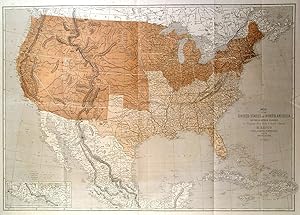
'MAP OF THE UNITED STATES OF NORTH AMERICA, UPPER & LOWER CANADA, NEW BRUNSWICK, NOVA SCOTIA & BRITISH COLUMBIA, MEXICO, CUBA, JAMAICA, ST.DOMINGO AND THE BAHAMA ISLANDS'. General map showing state and international boundaries, railroads, cities, rivers, and relief by hachures. Two colors are used to differentiate between Union and Confederate states.
Ettling, T.
Editore: Theodor Ettling 1861
Mappa
Condizione: Fine
Da Garwood & Voigt, Sevenoaks, Regno Unito
Valutazione del venditore 5 su 5 stelle
![]()
Venditore AbeBooks dal 25 novembre 2013
Usato -
Prezzo:
EUR 256,66
Convertire valuta
EUR 26,11
per la spedizione da Regno Unito a Italia
Destinazione, tempi e costi
Quantit�: 1 disponibili
Aggiungere al carrello