
1740 senex john (23 risultati)

- Brossura
Da: BargainBookStores, Grand Rapids, MI, U.S.A.BargainBookStores
Contatta il venditoreVenditore con 5 stelleCondizione: Nuovo
EUR 22,64
Spedizione gratuitaSpedito in U.S.A.Quantità: 5 disponibili
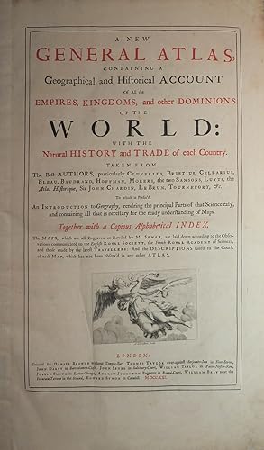
Paperback or Softback. Condizione: New. A New General Atlas, Containing a Geographical and Historical Account of All the Empires, Kingdoms, and Other Dominions of the World [microform]: With. Book.

- Brossura
Da: THE SAINT BOOKSTORE, Southport, Regno UnitoTHE SAINT BOOKSTORE
Contatta il venditoreVenditore con 5 stelleCondizione: Nuovo
EUR 16,86
EUR 13,76 spedizioneSpedito da Regno Unito a U.S.A.Quantità: Più di 20 disponibili
Paperback. Condizione: New. New copy - Usually dispatched within 4 working days.

- Brossura
Da: Chiron Media, Wallingford, Regno UnitoChiron Media
Contatta il venditoreVenditore con 5 stelleCondizione: Nuovo
EUR 18,08
EUR 18,18 spedizioneSpedito da Regno Unito a U.S.A.Quantità: 10 disponibili
PF. Condizione: New.
- Brossura
- Print on Demand
Da: THE SAINT BOOKSTORE, Southport, Regno UnitoTHE SAINT BOOKSTORE
Contatta il venditoreVenditore con 5 stelleCondizione: Nuovo
EUR 24,72
EUR 14,44 spedizioneSpedito da Regno Unito a U.S.A.Quantità: Più di 20 disponibili
Paperback / softback. Condizione: New. This item is printed on demand. New copy - Usually dispatched within 5-9 working days.

GEOGRAPHY ANATOMIZ'D: OR, THE GEOGRAPHICAL GRAMMAR. BEING A SHORT AND EXACT ANALYSIS OF THE WHOLE BODY OF MODERN GEOGRAPHY, AFTER A NEW AND CURIOUS METHOD. COMPREHENDING . . . (Spine title: "Gordon's Geographic Grammar.") [Geography Anatomized.]
Gordon, Pat [Patrick Gordon]. John Senex, 1678-1740 (cartographer).
Editore: Dublin [Ireland]: Printed by R. Reilly, on Cork-hill, for G. Risk, G. Ewing, W. Smith, and P. Crampton, in Dame-street, and G. Faulkner, in Essex-street, Booksellers, 1739., 1739
- Rilegato
Da: David Hallinan, Bookseller, Columbus, MS, U.S.A.David Hallinan, Bookseller
Contatta il venditoreVenditore con 5 stelleCondizione: Usato
EUR 1671,16
EUR 6,58 spedizioneSpedito in U.S.A.Quantità: 1 disponibili
Aggiungi al carrelloFull title - GEOGRAPHY ANATOMIZ'D: OR, THE GEOGRAPHICAL GRAMMAR. BEING A SHORT AND EXACT ANALYSIS OF THE WHOLE BODY OF MODERN GEOGRAPHY, AFTER A NEW AND CURIOUS METHOD. COMPREHENDING I. A GENERAL VIEW OF THE TERRAQUEOUS GLOBE; BEING A COMPENDIOUS SYSTEM OF THE TRUE FUNDAMENTALS OF GEOGRAPHY; DIGESTED INTO VARIOUS DEFINITIONS, PR…OBLEMS, THEOREMS AND PARADOXES: WITH A TRANSIENT SURVEY OF THE SURFACE OF THE EARTHLY BALL, AS IT CONSISTS OF LAND AND WATER. II. A PARTICULAR VIEW OF THE TERRAQUEOUS GLOBE; BEING A CLEAR AND PLEASANT PROSPECT OF ALL REMARKABLE COUNTRIES UPON THE FACE OF THE WHOLE EARTH; SHEWING THEIR SITUATION, EXTENT, DIVISION, SUB-DIVISION, CITIES, CHIEF TOWNS, NAME, AIR, SOIL, COMMODITIES, RARITIES, ARCHBISHOPRICKS, BISHOPRICKS, UNIVERSITIES, MANNERS, LANGUAGES, GOVERNMENT, ARMS, RELIGION. COLLECTED FROM THE BEST AUTHORS, AND ILLUSTRATED WITH DIVERS MAPS. THE FIFTEENTH EDITION, CORRECTED AND SOMEWHAT ENLARGED; AND A SET OF NEW MAPS, BY MR. SENEX. BY PAT. GORDON, M.A. F.R.S. 15th edition. Hardcover: H 20.6cm x L 13.3cm. Collates as [fp], [1-16], [foldout "A New and Correct Map of the World"], 1-56, [foldout map "Europe According to the Latest Observations"], 57-58, [foldout "A New Map of Scandinavia . . ."], 59-72, [foldout "A New Map of Moscovy . . ."], 73-78, [foldout "A New Map of France . . ."], 79-96, [foldout "A New Map of Germany . . ."], 97-126, [foldout "A New Map of Poland . . ."], 127-134, [foldout "A New Map of Spain & Portugal . . ."], 135-146, [foldout "A New Map of Italy . . ."], 147-166, [foldout "A New Map of Turky in Europe . . ."], 167-186, [foldout "A New Map of Scotland . . ."], 187-196, [foldout "A New Map of England . . ."], 197-212, [foldout "A New Map of Ireland . . ."], 213-238, [foldout map "Asia According to the Latest Observations"], 239-272, 271-272, 273-290, [foldout map "Africa According to the Latest Observations"], 291-330, [foldout map "North America According to the Latest Observations"], 331-354, [foldout map "South America According to the Latest Observations"], 355-414, [rfep], [rp]. Contemporary full leather darkened and scuffed; board edges worn with some peeling/chipping to surface leather; front board only tenuously attached with rear board pliable but holding; shallow wear to spine head with heel scuffed; spine with five raised bands and its maroon title label mostly intact and retaining reasonably bright gilt lettering. Book now presented in a trimmed clear Dura-Lar (polyester film) sheet forming a dj which aids in securing the boards and modestly enhances the book's shelf appearance. Interior toning/foxing with some soiling and stains. Missing preliminary blanks, i.e. ffep and perhaps a ffly; title leaf is immediately opposite front pastedown both of which are chipped at margins; title page is rubricated (red and black type); might be missing a rfly; large chipping with text loss to last leaf (pages 413-414); large loss to detached rfep; pencil note to chipped rear pastedown. Type error so that page 79 is actually numbered 76; also page numbers 271-272 are repeated but the text on the two leaves is different and sequiturous so an error by the typesetter but pagination sequence continues onward without adjustment. Seventeen b/w foldout maps are present (book's Contents leaf does not indicate how many maps were included) but appears to be complete with no stubs or other indicators of a missing plate (OCLC citations do not mention map count either). Leadoff double hemisphere world map does show California as an island; North America map has 15cm tear ascending from fold heel and, again, shows California as an island. Antiquarian ink signature "John Murray Robertson" at top of title page. Acquired from a modest collection of eighteenth and early nineteenth century legal and medical works from a Columbus, Mississippi estate which had familial roots to the Maryland Eastern Shore and the hamlet of Cambridge in Dorchester County with descent from Maryland U.S. Representative and ambassador William Vans Murray (1760-1803) and/or his nephew William Vans Murray Robertson (1797 or 1799-1836). Cursory online research turns up a Cambridge-born Reverend John Murray Robertson (1804-1878) who resided in Huntsville, Alabama circa 1850 but the ownership signature seems to be more 18th century in style and ink so the best guess is that John Murray Robertson is a 1700s progenitor to these extended family members.
Editore: [London:] Revised by John Senex, 1719, 1719
- Rilegato
Da: Arader Galleries - AraderNYC, New York, NY, U.S.A.Arader Galleries - AraderNYC
Contatta il venditoreVenditore con 5 stelleCondizione: Usato
EUR 1626,00
Spedizione gratuitaSpedito in U.S.A.Quantità: 1 disponibili
Aggiungi al carrelloHardcover. Engraved map (Sheet: 21 x 25 in.; 53.3 x 63.5 cm) with original handcoloring in outline. CONDITION/BINDING: A few expertly closed tears along centerfold. Floated on a mat and enclosed in mylar. (65B1D) A reissue of the ca. 1695 Morden-Browne map, with the Senex name replacing that of Morden and the royal arms substitu…ted with a cartouche dedicated to Herver Edgly Herver. The map was included in Senex's New General Atlas of the World published in 1721. "The unique features of the map are the extensions of the Appalachian Mountain range. A branch extends southwards towards the Mississippi River and north into the Michigan peninsula. The peninsula bears a broad plateau along its length and nearby is stated 'On Top of these Mountains is a Plaine like a Terras Walk aboue 200 miles in length' " (Burden). Both the mountain range and the plain extending into Michigan were purely an example of imagined topography. REFERENCES: Burden 750, state 4; Cumming 172; Stevens & Tree 20b.
Editore: [London: Mary Senex, ca 1740]., 1740
- Rilegato
Da: Arader Galleries - AraderNYC, New York, NY, U.S.A.Arader Galleries - AraderNYC
Contatta il venditoreVenditore con 5 stelleCondizione: Usato - Molto buono
EUR 31.616,62
Spedizione gratuitaSpedito in U.S.A.Quantità: 1 disponibili
Aggiungi al carrelloHardcover. Condizione: Very Good. Large folio (27 4/8 x 21 4/8 inches). Letterpress broadside "A Catalogue of the Maps as they are placed in this Book" pasted inside front cover, and another "A Catalogue of Globes, Maps, &c made by the late John Senex, F.R.S. and continue to be sold by his Widow Mary Senex, at the Globe." (earli…est state mentioning the eclipse of 1738). 34 magnificent engraved maps, including 21 double-page and 13 full-page, each with elaborate allegorical cartouches, and with original hand-colour in outline (one or two creases). Contemporary half calf (quite worn). Provenance: 19th-century South Library bookplate of the Earls of Macclesfield on the front paste-down dated 1860; their sale Macclesfield Library Part Nine: Voyages, Travel and Atlases, 15th March 2007, lot 3283 An important atlas, most commonly attributed to John Senex, which has its genesis in the partnership of Charles Price Sr. and John Senex in 1707. Price was apprenticed to John Seller Sr., and then worked in partnership with his heir Jeremiah Seller, until their partnership ended in bankruptcy in 1706. Latterly Seller and Price worked in association (partnership) with John Senex, from separate addresses. After the bankruptcy, Price joined Senex, and worked from his address "next to the Fleece Tavern in Cornhill". In 1707, the partners announced the "New Sett of Correct Maps" (Daily Courant, 24 September 1707), a series of elephant folio maps, printed on two sheets joined, to be printed as completed, with the intention of making up an atlas of twenty maps, with Price the mapmaker and Senex the engraver. As with many of the atlas projects of this date, the partners were soon in financial trouble, and John Maxwell joined the partnership. Financial woes continued, and this partnership was also dissolved. Price left the partnership, taking some of the map plates, with the rest retained by Senex, to join George Willdey and Timothy Brandreth. Both partners then had new plates engraved to make up a world atlas. Price, Brandreth and Willdey advertised their set of maps in the Post Man on 23-25 August 1711. Senex and Maxwell advertised their atlas in the Spectator for 1 October 1711. Willdey's atlas is appreciably rarer as he seems not to have recovered from the costs of financing his version; Senex, on the other hand, survived the start-up costs, and his atlas, sometimes referred to as 'The English Atlas', prospered, re-issued by Senex and then his widow Mary Senex into the 1740s, and by the Bowles family, and partners, in the 1750s. Once Maxwell left the partnership, Senex gradually removed existing references to his ex-partners, and following his election to the Royal Society in 1728, added the initials "F.R.S." to his name on various of the maps. This copy of the Price-Senex atlas is in the mature form attained post-1728, notoriously difficult to date after that point. From the celebrated library of the Earls of Macclesfield at Shirburn Castle, Oxfordshire, England, accumulated from the early 18th century by generations of of the Parker family, and sold (over successive sales) by Sothebys. The first Earl of Macclesfield was Thomas Parker, 1st Baron Parker, made Viscount Parker, of Ewelm in the County of Oxford, and Earl of Macclesfield, in the County Palatine of Chester in 1716. He was Lord Chief Justice of the Queen's Bench from 1710 to 1718 and Lord High Chancellor from 1718 to 1725. Probably acquired by Thomas Augustus Wolstenholme Parker, 6th Earl of Macclesfield (17 March 1811 - 24 July 1896) Conservative Member of Parliament for Oxfordshire from 1837 until 1841.Armitage 145. Shirley T.SE-1f. Catalogued by Kate Hunter.
Editore: [London: Mary Senex, after 1740.], 1740
- Rilegato
Da: Arader Galleries - AraderNYC, New York, NY, U.S.A.Arader Galleries - AraderNYC
Contatta il venditoreVenditore con 5 stelleCondizione: Usato
EUR 14.633,98
Spedizione gratuitaSpedito in U.S.A.Quantità: 1 disponibili
Aggiungi al carrelloHardcover. Folio (28 x 13 inches). Letterpress "Catalogue" listing 34 items laid down on the recto of the second blank, "A Catalogue of Globes, Maps, &c. made by the late John Senex, F.R.S" recording the eclipse of February 1736-7 (frayed at outer edges, lightly soiled and with edges renewed). 34 engraved maps, including 13 full…-page and Ancient Greece bound as two sheets, the others double-page, all accept the astronomical chart with contemporary hand-colour in full (lower edges extensively repaired, each map laid down on archival tissue). Modern brown cloth. This important atlas, although most commonly attributed to John Senex, had its genesis in the partnership of Charles Price Sr. and John Senex in 1707. Price was apprenticed to John Seller Sr., and then worked in partnership with his heir Jeremiah Seller, until their partnership ended in bankruptcy in 1706. Latterly Seller and Price worked in association (partnership) with John Senex, from separate addresses. After the bankruptcy, Price joined Senex, and worked from his address "next to the Fleece Tavern in Cornhill". In 1707, the partners announced the "New Sett of Correct Maps" (Daily Courant, 24th September 1707), a series of elephant folio maps, printed on two sheets joined, to be printed as completed, with the intention of making up an atlas of twenty maps, with Price the mapmaker and Senex the engraver. As with many of the atlas projects of this date, the partners were soon in financial trouble, and John Maxwell joined the partnership. Financial woes continued, and this partnership was also dissolved. Price left the partnership, taking some of the map plates, with the rest retained by Senex, to join George Willdey and Timothy Brandreth. Both partners then had new plates engraved to make up a world atlas. Price, Brandreth and Willdey advertised their set of maps in the Post Man on 23 / 25 August 1711. Senex and Maxwell advertised their atlas in the Spectator for 1 October 1711. Willdey's atlas is appreciably rarer as he seems not to have recovered from the costs of financing his version; Senex, on the other hand, survived the start-up costs, and his atlas, sometimes referred to as "The English Atlas", prospered, re-issued by Senex and then his widow Mary Senex into the 1740s, and by the Bowles family, and partners, in the 1750s. Once Maxwell left the partnership, Senex gradually removed existing references to his ex-partners, and following his election to the Royal Society in 1728, added the initials "F.R.S." to his name on various of the maps. This copy of the Price-Senex atlas is in the mature form attained post-1728, notoriously difficult to date after that point. However, both the World and North Americas are in the first state to acknowledge Senex's election to the Royal Society, retaining the delineation of California as an island. Both maps were subsequently re-engraved with California re- attached to the mainland, and the North America with Georgia marked; either the atlas was made up with old paper stock or assembled rather earlier than the catalogue would indicate. Shirley, British Library T.SEN-1e. Catalogued by Kate Hunter.
 Altre immagini
Editore: London: Daniel Browne, Thomas Taylor, John Darby, John Senex and others, 1721., 1721
- Rilegato
- Prima edizione
Da: Arader Galleries - AraderNYC, New York, NY, U.S.A.Arader Galleries - AraderNYC
Contatta il venditoreVenditore con 5 stelleCondizione: Usato
EUR 31.616,62
Spedizione gratuitaSpedito in U.S.A.Quantità: 1 disponibili
Aggiungi al carrelloHardcover. 1st Edition. Folio (21 x 13 inches). Letterpress title-page printed in red and black with engraved vignette, list of subscribers. 13 engraved plates showing the arms of the subscribers, 34 double-page or folding engraved maps and plates, the maps with contemporary colour in outline, plans of London, Amsterdam and Rome… uncoloured (Maps of Germany, France, and Spain with early repairs to verso and with top edges partially renewed). 19th-century half crimson morocco, marbled boards, gilt (rebacked preserving the original spine). Provenance: with the engraved armorial bookplate of Richard Griffin [formerly Richard Aldworth Neville], second Baron Braybrooke (1750-1825), dated 1798 the date he succeeded to the Braybrooke title, on the front paste-down. "THE MOST ELEGANT ENGLISH ATLAS OF ALL TIME" (Worms) First edition. Of the maps in the "New General Atlas", ten are apparently new plates (Europe; Moscovy; Amsterdam; France; Sicily; England; Ireland; India; Africa; Louisiana); two originated with Morden (English Empire in America; Golden Islands & Darien, the latter engraved by Moll), the first map of France also possibly, eight from Browne's stock (Denmark; Scandinavia; Spain; Rome; Bernard Randolph's Greece; Virginia; West Indies and Scotland, this latter commenced by Morden and completed by Browne), and possibly also the Spanish Netherlands, Switzerland and Savoy. Of the maps of uncertain attribution five are engraved by John Harris, who worked both for Morden and Browne (Poland; Italy; Savoy; Hungary; America), and one by Samuel Parker (London), and eight without any attribution at all (World; Germany; United Provinces; Spanish Netherlands; France; Switzerland; Asia; Turkey). Including many important maps relating to America: "New Map of the World"; "Virginia, Maryland, and the improved parts of Pennsylvania & New Jersey"; "The English Empire in the Ocean of America or West Indies"; "Louisiana and of the River Mississipi"; and the "Isthmus of Darien in America". Bookseller, publisher and maker of maps and globes, Senex was "long concerned in the production of maps and atlases. Between 1707 and 1711 he worked with Price (and later Maxwell) on a large atlas series, issuing in 1707 broadside 'Proposals for a new sett of correct mapps' advertising the partners as 'Geographers to the Queen' and promising work that 'shall in correctness, and all other particulars, far exceed any yet done'. Senex and Price subsequently went their separate ways but Senex at length produced (with Maxwell) an augmented version of these maps as "The English Atlas" (1714), the bulk of the work engraved by himself. His portable version of the road maps of John Ogilby, published as "An Actual Survey of All the Principal Roads of England and Wales" in 1719, was a popular success, staying in print for many years, while his "A New General Atlas" (1721) remains the most elegant English world atlas of the time. "The Atlas maritimus & commercialis" (1728), a work to which Halley lent his assistance and the text for which is said to have been written by Defoe, featured maps drawn on a new 'globular' projection patented in 1721, which Senex had himself devised in association with John Harris and Henry Wilson. NMM 3:434; Phillips Atlases 563; Sabin 79124; Shirley, British Library T.SEN-2a. Catalogued by Kate Hunter.

- Rilegato
- Print on Demand
Da: THE SAINT BOOKSTORE, Southport, Regno UnitoTHE SAINT BOOKSTORE
Contatta il venditoreVenditore con 5 stelleCondizione: Nuovo
EUR 38,22
EUR 14,44 spedizioneSpedito da Regno Unito a U.S.A.Quantità: Più di 20 disponibili
Hardback. Condizione: New. This item is printed on demand. New copy - Usually dispatched within 5-9 working days.

A New Map of London. Most humbly Inscrib'd to the Rt. Worshipfull Sr. Peter Delmé Kt. & Aldermn. of London 1720. Revised by In. Senex. A Plan of the City's of London, Westminster and Borough of Southwark, with the new Additional Buildings Anno, 1720. Large Reproduction of a city plan of London. Lithograph by Edward S. Weller ca. 1860
Samuel Parker (1695-1728), britischer Zeichner, Kupferstecher unf Kartograph; John Senex (1678-1740), englischer Kartograph, Kupferstecher, Buchhändler und Verleger von Landkarten, Atlanten und Globen, königlicher Geograph; Edward.S. Weller (gestorben 1884), britischer Lithograph; Sir Peter Delmé (gestorben 1728), erfolgreicher und vermögender Londoner Kaufmann, später Governeur der Bak of England, Sheriff of London, 1723 Mayor of London
Editore: London: Cassell & Company ca, 1860
- Firmato
- Mappa
Da: historicArt Antiquariat & Kunsthandlung, Wiesbaden-Breckenheim, GermaniahistoricArt Antiquariat & Kunsthandlung
Contatta il venditoreVenditore con 5 stelleCondizione: Usato
EUR 350,00
EUR 12,00 spedizioneSpedito da Germania a U.S.A.Quantità: 1 disponibili
Aggiungi al carrello2. very large and attractive folding map of London, map size ca. 50,5 x 67 cm, during the reign of George I., drawn on stone by Edward S. Weller after the plan of London, published by John Senex and engraved by Samuel Parker on copper plates, covering the area from Clerkenwell to Lambeth, St. James to Wapping, title above the ma…p with a decorative dedication cartouche, adorned with the emblems of the City of London, cornucopias, coat-of-arms and insignias, dedicated to the wealthy London merchant and banker Sir Peter Delmé, across the lower part of the map an index, locating parishes in London and churches and buildings in Westminster and Southwark, our copy of this rare map drawn on stone by Edward S. Weller on clean paper (verso blank), published with part 8 of the "People's Weekly Edition of Cassell's Old & New London", some small tears in the margins, otherwise in good condition and very rare - großer und/oder schwerer Artikel mit zusätzlichen Kosten für Versand und Versicherung - heavy and/or oversized item with additional costs for shipping and insurance - please ask us before you order this article 2100 gr.

Editore: London : printed for J Senex at the Globe in Salisbury Court, and W. Taylor at the Ship in Pater-Noster-Row. 1716, 1716
- Arte / Stampa / Poster
Da: Wittenborn Art Books, San Francisco, CA, U.S.A.Wittenborn Art Books
Contatta il venditoreVenditore con 5 stelleCondizione: Usato - Buono
EUR 632,33
EUR 8,77 spedizioneSpedito in U.S.A.Quantità: 1 disponibili
Aggiungi al carrelloCondizione: Good. Engraverd map , Handcolored. Centerfold, as issued. 42/5 x 53cm. Old laid paper, watermarked with a shield.Laurence Worms - Ash Rare Books : "Senex finished his seven-year apprenticeship in August 1702 and immediately opened his own shop: his father had died the previous year - there was probably an inheritance…. It was "opposite to the South Portico of St. Clement's Church in the Strand" - this would have been more or less the view from his window. His earliest publications were modest enough, standard fare for the period, but one of these early books, seemingly his first solo publication, was a fresh edition of Caradoc's "History of Wales", published in 1702. Clavell had brought out an edition a few years earlier, but the difference was that Senex now included a little map.He and a new partner, John Maxwell, returned to retail premises at the Sign of the Globe, "going into Salisbury Court", off Fleet Street. I take this to be the Maxwell who later translated Isaac Newton's "General Scholium", published by Senex in 1715.".

Editore: London : printed for J Senex at the Globe in Salisbury Court, and W. Taylor at the Ship in Pater-Noster-Row. 1716, 1716
- Arte / Stampa / Poster
Da: Wittenborn Art Books, San Francisco, CA, U.S.A.Wittenborn Art Books
Contatta il venditoreVenditore con 5 stelleCondizione: Usato - Buono
EUR 632,33
EUR 8,77 spedizioneSpedito in U.S.A.Quantità: 1 disponibili
Aggiungi al carrelloCondizione: Good. Engraved map. Handcolored. Centerfold, as issued. 42,5 x 53cm. Old laid paper. Stain upper right.Ruderman: "Rare map of the Holy Land and contiguous parts of the Middle East and Cyprus.The map shows Eden just below the confluence of the Euphrates River and the Tigris River, with references to Exodus and the Boo…k of Numbers.The map extends to Noah's Arc on Mount Ararat and the Persian Gulf in the east, centered on Babel, Niniveh and Ur, with numerous vignettes from the Old Testament throughout the map. ".Laurence Worms - Ash Rare Books : "Senex finished his seven-year apprenticeship in August 1702 and immediately opened his own shop: his father had died the previous year - there was probably an inheritance. It was "opposite to the South Portico of St. Clement's Church in the Strand" - this would have been more or less the view from his window. His earliest publications were modest enough, standard fare for the period, but one of these early books, seemingly his first solo publication, was a fresh edition of Caradoc's "History of Wales", published in 1702. Clavell had brought out an edition a few years earlier, but the difference was that Senex now included a little map.He and a new partner, John Maxwell, returned to retail premises at the Sign of the Globe, "going into Salisbury Court", off Fleet Street. I take this to be the Maxwell who later translated Isaac Newton's "General Scholium", published by Senex in 1715.".

Editore: Senex, London, 1720
- Mappa
Da: Donald A. Heald Rare Books (ABAA), New York, NY, U.S.A.Donald A. Heald Rare Books (ABAA)
Contatta il venditoreVenditore con 5 stelleCondizione: Usato
EUR 1129,17
EUR 21,93 spedizioneSpedito in U.S.A.Quantità: 1 disponibili
Aggiungi al carrelloCopper-engraved map by Samuel Parker, with full modern colour, skillfully repaired split at top of centerfold, overall in very good condition. A fascinating, highly detailed map of London by one of the leading English cartographers of the period. This is an excellent parish by parish, block by block map of the London that was bu…ilt after the Great Fire of 1666. (St. Paul's was completed in 1710). The map includes an index that locates the 87 parishes in London and Westminster, and eight in Southwark. Many parishes had new churches built between the years 1670 and 1711, 52 of which were designed and executed by Christopher Wren. Samuel Parker, the engraver, did a superb job of drawing and engraving so that minute details of the city's topography are shown. The attractive cartouche includes symbols of London's greatness: two cornucopeias, one of fruit and one of precious metal objects and jewels. At the base is a picture of a king, presumably George I, whose sword and scepter are supported by two dragons. To the sides and behind these are symbols of British cultural and mercantile superiority. The map is dedicated to Sir Peter Delme, a very wealthy and powerful gentleman, one of the first residents of Grosvenor Square, and, for a time, Lord Mayor. Darlington & Howgego, Printed Maps of London, 65.

Editore: Thomas Bowles, John Bowles & Son, Robt. Sayer, [London], 1712
- Mappa
Da: Donald A. Heald Rare Books (ABAA), New York, NY, U.S.A.Donald A. Heald Rare Books (ABAA)
Contatta il venditoreVenditore con 5 stelleCondizione: Usato
EUR 767,83
EUR 21,93 spedizioneSpedito in U.S.A.Quantità: 1 disponibili
Aggiungi al carrelloEngraved with contemporary outline color, small marginal tears. Large, handsome and interesting map of Russia at the time of Peter the Great. An attractive double folio sized map of European Russia by the great English cartographer, John Senex (1678-1740). Russia was continually expanding during this period in virtually every di…rection, though the expansion westward was always more costly. The map notes "Petersburg," which was Peter the Great's most prized accomplishment, giving Russia access to the Baltic and a new, more "European" capital. There would ultimately be more territory added to the northwestern boundary, which was won after years of struggle with Sweden and the Poland-Lithuania Commonwealth. The map extends to the Sea of Azov in the south to include Ukraine, called here "Ukraine Land of the Cosaques" and several regions farther south and east called "Cosaques Zaporoski" and "Cosaques Donski." The map was made during the reign of Peter the Great, who, while the country was growing territorially, advanced European ideas and manners, despite the recalcitrant Orthodox hierarchy. The very idea of nationhood was new to Russia and the country in a generally reluctant way began to modernise. Nevertheless, the map notes the location of many monasteries, which indicates how important and pervasive the old religion was. Senex also provides interesting historical notes, for example, "Deserts where are the ruins of many Citys (sic) and Towns destroyed by Tamerlan" not far from the Volga River.
Editore: Artist: Senex John ( - 1740 ) London ca : 1720, 1678
Da: Antique Sommer& Sapunaru KG, München, GermaniaAntique Sommer& Sapunaru KG
Contatta il venditoreVenditore con 4 stelleCondizione: Usato
EUR 1010,00
EUR 45,00 spedizioneSpedito da Germania a U.S.A.Quantità: 1 disponibili
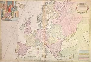
Aggiungi al carrelloTechnic: Copper print, colorit: original colored, condition: Printed on 2 sheets joined together, folds partly restored, size (in cm): 63,5 x 94 cm, Map shows the whole of Europe with a splendid title cartouche.
Editore: Artist: Senex John ( - 1740 ) London ca : 1710, 1678
Da: Antique Sommer& Sapunaru KG, München, GermaniaAntique Sommer& Sapunaru KG
Contatta il venditoreVenditore con 4 stelleCondizione: Usato
EUR 580,00
EUR 45,00 spedizioneSpedito da Germania a U.S.A.Quantità: 1 disponibili
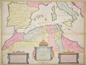
Aggiungi al carrelloTechnic: Copper print, colorit: original colored, condition: Some folds perfectly restored, size (in cm): 47,5 x 62, Map shows the western Mediterranean sea with its islands and the norther coast of Africa.
Editore: Artist: Senex John ( - 1740 ) London ca : 1710, 1678
Da: Antique Sommer& Sapunaru KG, München, GermaniaAntique Sommer& Sapunaru KG
Contatta il venditoreVenditore con 4 stelleCondizione: Usato
EUR 1570,00
EUR 45,00 spedizioneSpedito da Germania a U.S.A.Quantità: 1 disponibili
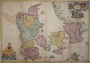
Aggiungi al carrelloTechnic: Copper print, colorit: original colored, condition: Marins replaced, missing parts in folding area on lower right and upper left side replaced, size (in cm): 66,5 x 96 cm, Map shows the whole of Denmark with 2 magnificent cartouches, coats of arms and several ship staffages. Double-page engraved map on 2 sheets joined.
Editore: Artist: Senex John ( - 1740 ) London dated : 1709, 1678
Da: Antique Sommer& Sapunaru KG, München, GermaniaAntique Sommer& Sapunaru KG
Contatta il venditoreVenditore con 4 stelleCondizione: Usato
EUR 1510,00
EUR 45,00 spedizioneSpedito da Germania a U.S.A.Quantità: 1 disponibili
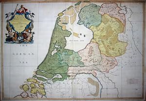
Aggiungi al carrelloTechnic: Copper print, colorit: original colored, condition: Upper margin, some small tears perfectly restored, size (in cm): 64,5 x 94 cm, Map shows the entire Netherlands with magnificent title cartouche, with the sea god Neptune, mermaids and ?seahorses..

Editore: Artist: Senex John ( - 1740 ) London ca : 1728, 1678
Da: Antique Sommer& Sapunaru KG, München, GermaniaAntique Sommer& Sapunaru KG
Contatta il venditoreVenditore con 4 stelleCondizione: Usato
EUR 600,00
EUR 45,00 spedizioneSpedito da Germania a U.S.A.Quantità: 1 disponibili
Aggiungi al carrelloTechnic: Copper print, colorit: original colored, condition: Lower margin perfectly restored, size (in cm): 49,5 x 59,5, Map shows the northern part of Brasil.

Editore: J. Senex, London, 1721
- Mappa
Da: Donald A. Heald Rare Books (ABAA), New York, NY, U.S.A.Donald A. Heald Rare Books (ABAA)
Contatta il venditoreVenditore con 5 stelleCondizione: Usato
EUR 2710,00
EUR 21,93 spedizioneSpedito in U.S.A.Quantità: 1 disponibili
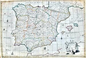
Aggiungi al carrelloCopper-engraved map, with original outline colour. A highly-important and finely-drafted map of Virginia, Maryland and Delaware by a great English cartographer. This very elegant map is centered on Chesapeake Bay, and embraces all of the territory from Norfolk, Virginia up past Philadelphia in the north. Its antecedent was Augus…tine Herrman's 1673 manuscript map, which was first printed by Christopher Browne in 1685. Senex devised his own version of the map in 1719, and included it in his New General Atlas of 1721. The Browne map is extremely rare, making the present map the earliest reasonably obtainable example of this critical map. This map is one of the first of the subject to be oriented with the north on the top, and demonstrates that the geography of the region was by this time very well understood. The long-established provinces of Virginia and Maryland dominate the map, and in the north is the relatively new colony of Pennsylvania, founded by William Penn in 1681. Delaware is shown to be at this time still an appendage of Pennsylvania, known as the 'Lower Counties' of Penn's Grant. New Jersey is shown to be divided into East and West Jersey. An elegant Baroque title cartouche adorns the upper left corner. Morrison On the Map 24; Stevens & Tree "Comparative Cartography" in TooleyThe Mapping of America 86(c); Stevenson & McKee Virginia in Maps p.78.
Editore: c. 1720, Londres, 1720
- Arte / Stampa / Poster
Da: Frame, Madrid, M, SpagnaFrame
Contatta il venditoreVenditore con 5 stelleCondizione: Usato - Buono
EUR 2045,00
EUR 50,00 spedizioneSpedito da Spagna a U.S.A.Quantità: 1 disponibili
Aggiungi al carrelloCondizione: ACEPTABLE. According to the new Observations and Discoveries comunicated to the Royal Society at London and the Royal Academy ap Paris. Is humbly dedicated to the Right Honorable Iohn. Ld. Somers Baron of Evesham.Obeisents Servants C. Price and I. Senex, Geographers to the Queen (2) C. Price Delin I. Senex Sculp Form…ato (cm): 92x62.
Editore: [London, 1719]., 1719
Da: Arader Galleries - AraderNYC, New York, NY, U.S.A.Arader Galleries - AraderNYC
Contatta il venditoreVenditore con 5 stelleCondizione: Usato
EUR 1716,33
Spedizione gratuitaSpedito in U.S.A.Quantità: 1 disponibili
Aggiungi al carrelloSingle sheet (19 x 22 inches to the neat-line, full margins showing the plate-mark). A fine engraved map showing North and South America with original hand-colour in outline, the title within an elaborate cartouche illustrated with vignettes reminiscent of the illustrations to de Bry's "Great Voyages". An attractive and unusual…map: one of the few English maps to show California as an island, in this case based on the information in Sanson's map "Amerique Septentrionale" of 1650 misconception which persisted on and off until 1747; and with a spurious northwest coastline and internal lakes including "The Great Lake of Thoago or Thoya". Senex, who issued a series of atlases with John Maxwell and Charles Price, was one of the most successful mapmakers during the golden age of English cartography. In recognition of his work he was appointed Geographer to Queen Anne, and elected to the Royal Society in 1728. His beautiful maps are famed for their meticulous detail and ornate cartouches, and they remain some of the best examples of eighteenth-century English mapmaking. McLaughlin 193; Tooley p. 130; 81. Wagner 520.


