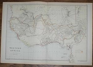
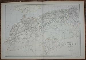
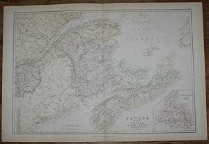
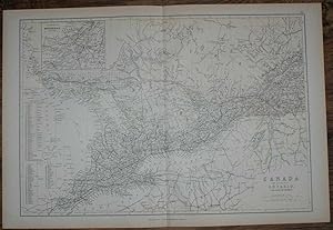
Bartholomew drawn engraved (17 risultati)
 Altre immagini
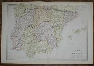
Editore: Blackie & Son, London, Glasgow, Edinburgh and Dublin 1884
- Brossura
- Mappa
Da: Bailgate Books Ltd, Doncaster, , Regno UnitoBailgate Books Ltd
Contatta il venditoreVenditore con 5 stelleCondizione: Usato - Molto buono
EUR 15,24
EUR 16,77 spedizioneSpedito da Regno Unito a U.S.A.Quantità: 1 disponibili
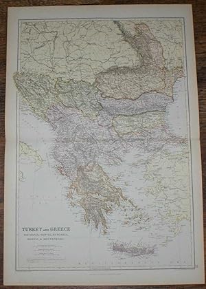
Softcover. Condizione: Very Good. No Dust Jacket. Early Edition. Disbound map from the 1884 "Comprehensive Atlas & Geography of the World: Comprising an Extensive Series of Maps, a Description, Physical and Political, of all the Countries of the Earth; a Pronouncing Vocabulary of Geographical Names, and a Copious Index of Geogra…phical Positions. Compiled and Engraved from the Most Authentic Sources, Under the Supervision of W. G. Blackie, PhD., F.S.A.Scot." Sheet number covers Single sheet with horizontal centre fold. Sheet is clean but slightly darkened at the edges. Map is drawn to a given scale with latitude and longitude lines, map is extensively labeled. Pastel shades have been used to denote countries and slightly darker shades have been used to denote boarders. Black and white engraved hatching shows landscape features. Size: 38x56cm. Item Type: Map. No dust jacket, as published. Single sheet map/chart which is suitable for framing. Illustrator: Drawn and Engraved by J. Bartholomew. Quantity Available: 1. Shipped Weight: under 1 kg. Pictures of this item not already displayed here available upon request. Inventory No: 45117104040. All our books are sent by tracked mail. Drawn and Engraved by J. Bartholomew (illustratore).
 Altre immagini
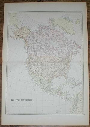
Editore: Blackie & Son, London, Glasgow, Edinburgh and Dublin 1884
- Brossura
- Mappa
Da: Bailgate Books Ltd, Doncaster, , Regno UnitoBailgate Books Ltd
Contatta il venditoreVenditore con 5 stelleCondizione: Usato - Molto buono
EUR 15,24
EUR 16,77 spedizioneSpedito da Regno Unito a U.S.A.Quantità: 1 disponibili
Softcover. Condizione: Very Good. No Dust Jacket. Early Edition. Disbound map from the 1884 "Comprehensive Atlas & Geography of the World: Comprising an Extensive Series of Maps, a Description, Physical and Political, of all the Countries of the Earth; a Pronouncing Vocabulary of Geographical Names, and a Copious Index of Geogra…phical Positions. Compiled and Engraved from the Most Authentic Sources, Under the Supervision of W. G. Blackie, PhD., F.S.A.Scot." Sheet number covers Single sheet with horizontal centre fold. Sheet is clean but slightly darkened at the edges. Map is drawn to a given scale with latitude and longitude lines, map is extensively labeled. Pastel shades have been used to denote countries and slightly darker shades have been used to denote boarders. Black and white engraved hatching shows landscape features. Size: 38x56cm. Item Type: Map. No dust jacket, as published. Single sheet map/chart which is suitable for framing. Illustrator: Drawn and Engraved by J. Bartholomew. Quantity Available: 1. Shipped Weight: under 1 kg. Pictures of this item not already displayed here available upon request. Inventory No: 45117104041. All our books are sent by tracked mail. Drawn and Engraved by J. Bartholomew (illustratore).
 Altre immagini
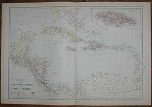
Editore: Blackie & Son, London, Glasgow, Edinburgh and Dublin 1884
- Brossura
- Mappa
Da: Bailgate Books Ltd, Doncaster, , Regno UnitoBailgate Books Ltd
Contatta il venditoreVenditore con 5 stelleCondizione: Usato - Molto buono
EUR 16,20
EUR 16,77 spedizioneSpedito da Regno Unito a U.S.A.Quantità: 1 disponibili
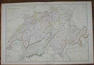
Softcover. Condizione: Very Good. No Dust Jacket. Early Edition. Disbound map from the 1884 "Comprehensive Atlas & Geography of the World: Comprising an Extensive Series of Maps, a Description, Physical and Political, of all the Countries of the Earth; a Pronouncing Vocabulary of Geographical Names, and a Copious Index of Geogra…phical Positions. Compiled and Engraved from the Most Authentic Sources, Under the Supervision of W. G. Blackie, PhD., F.S.A.Scot." Single sheet with vertical centre fold. Sheet is clean but slightly darkened at the edges. Map is drawn to a given scale with latitude and longitude lines, map is extensively labeled. Pastel shades have been used to denote countries and slightly darker shades have been used to denote boarders. Black and white engraved hatching shows landscape features. Size: 38x56cm. Item Type: Map. No dust jacket, as published. Single sheet map/chart which is suitable for framing. Illustrator: Drawn and Engraved by J. Bartholomew. Quantity Available: 1. Shipped Weight: under 1 kg. Pictures of this item not already displayed here available upon request. Inventory No: 45117104037. All our books are sent by tracked mail. Drawn and Engraved by J. Bartholomew (illustratore).
 Altre immagini
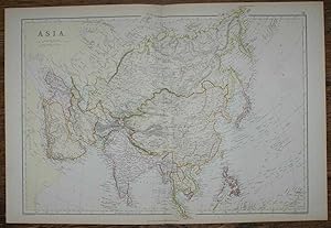
Editore: Blackie & Son, London, Glasgow, Edinburgh and Dublin 1884
- Brossura
- Mappa
Da: Bailgate Books Ltd, Doncaster, , Regno UnitoBailgate Books Ltd
Contatta il venditoreVenditore con 5 stelleCondizione: Usato - Molto buono
EUR 16,20
EUR 16,77 spedizioneSpedito da Regno Unito a U.S.A.Quantità: 1 disponibili
Softcover. Condizione: Very Good. No Dust Jacket. Early Edition. Disbound map from the 1884 "Comprehensive Atlas & Geography of the World: Comprising an Extensive Series of Maps, a Description, Physical and Political, of all the Countries of the Earth; a Pronouncing Vocabulary of Geographical Names, and a Copious Index of Geogra…phical Positions. Compiled and Engraved from the Most Authentic Sources, Under the Supervision of W. G. Blackie, PhD., F.S.A.Scot." Sheet number covers Single sheet with horizontal centre fold. Sheet is clean but slightly darkened at the edges. Map is drawn to a given scale with latitude and longitude lines, map is extensively labeled. Pastel shades have been used to denote countries and slightly darker shades have been used to denote boarders. Black and white engraved hatching shows landscape features. Size: 38x56cm. Item Type: Map. No dust jacket, as published. Single sheet map/chart which is suitable for framing. Illustrator: Drawn and Engraved by J. Bartholomew. Quantity Available: 1. Shipped Weight: under 1 kg. Pictures of this item not already displayed here available upon request. Inventory No: 45117104036. All our books are sent by tracked mail. Drawn and Engraved by J. Bartholomew (illustratore).
 Altre immagini
Editore: Blackie & Son, London, Glasgow, Edinburgh and Dublin 1884
- Brossura
- Mappa
Da: Bailgate Books Ltd, Doncaster, , Regno UnitoBailgate Books Ltd
Contatta il venditoreVenditore con 5 stelleCondizione: Usato - Molto buono
EUR 17,15
EUR 16,77 spedizioneSpedito da Regno Unito a U.S.A.Quantità: 1 disponibili
Softcover. Condizione: Very Good. No Dust Jacket. Early Edition. Disbound map from the 1884 "Comprehensive Atlas & Geography of the World: Comprising an Extensive Series of Maps, a Description, Physical and Political, of all the Countries of the Earth; a Pronouncing Vocabulary of Geographical Names, and a Copious Index of Geogra…phical Positions. Compiled and Engraved from the Most Authentic Sources, Under the Supervision of W. G. Blackie, PhD., F.S.A.Scot." Sheet number covers Single sheet with horizontal centre fold. Sheet is clean but slightly darkened at the edges. Map is drawn to a given scale with latitude and longitude lines, map is extensively labeled. Pastel shades have been used to denote countries and slightly darker shades have been used to denote boarders. Black and white engraved hatching shows landscape features. Size: 38x56cm. Item Type: Map. No dust jacket, as published. Single sheet map/chart which is suitable for framing. Illustrator: Drawn and Engraved by J. Bartholomew. Quantity Available: 1. Shipped Weight: under 1 kg. Pictures of this item not already displayed here available upon request. Inventory No: 45117104021. All our books are sent by tracked mail. Drawn and Engraved by J. Bartholomew (illustratore).
 Altre immagini
Editore: Blackie & Son, London, Glasgow, Edinburgh and Dublin 1884
- Brossura
- Mappa
Da: Bailgate Books Ltd, Doncaster, , Regno UnitoBailgate Books Ltd
Contatta il venditoreVenditore con 5 stelleCondizione: Usato - Molto buono
EUR 17,15
EUR 16,77 spedizioneSpedito da Regno Unito a U.S.A.Quantità: 1 disponibili
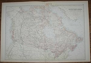
Softcover. Condizione: Very Good. No Dust Jacket. Early Edition. Disbound map from the 1884 "Comprehensive Atlas & Geography of the World: Comprising an Extensive Series of Maps, a Description, Physical and Political, of all the Countries of the Earth; a Pronouncing Vocabulary of Geographical Names, and a Copious Index of Geogra…phical Positions. Compiled and Engraved from the Most Authentic Sources, Under the Supervision of W. G. Blackie, PhD., F.S.A.Scot." Sheet number covers Single sheet with horizontal centre fold. Sheet is clean but slightly darkened at the edges. Map is drawn to a given scale with latitude and longitude lines, map is extensively labeled. Pastel shades have been used to denote countries and slightly darker shades have been used to denote boarders. Black and white engraved hatching shows landscape features. Size: 56x38cm. Item Type: Map. No dust jacket, as published. Single sheet map/chart which is suitable for framing. Illustrator: Drawn and Engraved by J. Bartholomew. Quantity Available: 1. Shipped Weight: under 1 kg. Pictures of this item not already displayed here available upon request. Inventory No: 45117104007. All our books are sent by tracked mail. Drawn and Engraved by J. Bartholomew (illustratore).
 Altre immagini
Editore: Blackie & Son, London, Glasgow, Edinburgh and Dublin 1884
- Brossura
- Mappa
Da: Bailgate Books Ltd, Doncaster, , Regno UnitoBailgate Books Ltd
Contatta il venditoreVenditore con 5 stelleCondizione: Usato - Molto buono
EUR 17,15
EUR 16,77 spedizioneSpedito da Regno Unito a U.S.A.Quantità: 1 disponibili
Softcover. Condizione: Very Good. No Dust Jacket. Early Edition. Disbound map from the 1884 "Comprehensive Atlas & Geography of the World: Comprising an Extensive Series of Maps, a Description, Physical and Political, of all the Countries of the Earth; a Pronouncing Vocabulary of Geographical Names, and a Copious Index of Geogra…phical Positions. Compiled and Engraved from the Most Authentic Sources, Under the Supervision of W. G. Blackie, PhD., F.S.A.Scot." Sheet number covers Single sheet with horizontal centre fold. Sheet is clean but slightly darkened at the edges. Map is drawn to a given scale with latitude and longitude lines, map is extensively labeled. Pastel shades have been used to denote countries and slightly darker shades have been used to denote boarders. Black and white engraved hatching shows landscape features. Size: 38x56cm. Item Type: Map. No dust jacket, as published. Single sheet map/chart which is suitable for framing. Illustrator: Drawn and Engraved by J. Bartholomew. Quantity Available: 1. Shipped Weight: under 1 kg. Pictures of this item not already displayed here available upon request. Inventory No: 45117104018. All our books are sent by tracked mail. Drawn and Engraved by J. Bartholomew (illustratore).
 Altre immagini
Editore: Blackie & Son, London, Glasgow, Edinburgh and Dublin 1884
- Brossura
- Mappa
Da: Bailgate Books Ltd, Doncaster, , Regno UnitoBailgate Books Ltd
Contatta il venditoreVenditore con 5 stelleCondizione: Usato - Molto buono
EUR 19,06
EUR 16,77 spedizioneSpedito da Regno Unito a U.S.A.Quantità: 1 disponibili
Softcover. Condizione: Very Good. No Dust Jacket. Early Edition. Disbound map from the 1884 "Comprehensive Atlas & Geography of the World: Comprising an Extensive Series of Maps, a Description, Physical and Political, of all the Countries of the Earth; a Pronouncing Vocabulary of Geographical Names, and a Copious Index of Geogra…phical Positions. Compiled and Engraved from the Most Authentic Sources, Under the Supervision of W. G. Blackie, PhD., F.S.A.Scot." Sheet number covers Single sheet with horizontal centre fold. Sheet is clean but slightly darkened at the edges. Map is drawn to a given scale with latitude and longitude lines, map is extensively labeled. Pastel shades have been used to denote countries and slightly darker shades have been used to denote boarders. Black and white engraved hatching shows landscape features. Size: 38x56cm. Item Type: Map. No dust jacket, as published. Single sheet map/chart which is suitable for framing. Illustrator: Drawn and Engraved by J. Bartholomew. Quantity Available: 1. Shipped Weight: under 1 kg. Pictures of this item not already displayed here available upon request. Inventory No: 45117104038. All our books are sent by tracked mail. Drawn and Engraved by J. Bartholomew (illustratore).
 Altre immagini
Editore: Blackie & Son, London, Glasgow, Edinburgh and Dublin 1884
- Brossura
- Mappa
Da: Bailgate Books Ltd, Doncaster, , Regno UnitoBailgate Books Ltd
Contatta il venditoreVenditore con 5 stelleCondizione: Usato - Molto buono
EUR 19,06
EUR 16,77 spedizioneSpedito da Regno Unito a U.S.A.Quantità: 1 disponibili
Softcover. Condizione: Very Good. No Dust Jacket. Early Edition. Disbound map from the 1884 "Comprehensive Atlas & Geography of the World: Comprising an Extensive Series of Maps, a Description, Physical and Political, of all the Countries of the Earth; a Pronouncing Vocabulary of Geographical Names, and a Copious Index of Geogra…phical Positions. Compiled and Engraved from the Most Authentic Sources, Under the Supervision of W. G. Blackie, PhD., F.S.A.Scot." Sheet number covers Single sheet with horizontal centre fold. Sheet is clean but slightly darkened at the edges. Map is drawn to a given scale with latitude and longitude lines, map is extensively labeled. Pastel shades have been used to denote countries and slightly darker shades have been used to denote boarders. Black and white engraved hatching shows landscape features. Size: 38x56cm. Item Type: Map. No dust jacket, as published. Single sheet map/chart which is suitable for framing. Illustrator: Drawn and Engraved by J. Bartholomew. Quantity Available: 1. Shipped Weight: under 1 kg. Pictures of this item not already displayed here available upon request. Inventory No: 45117104035. All our books are sent by tracked mail. Drawn and Engraved by J. Bartholomew (illustratore).
 Altre immagini
Editore: Blackie & Son, London, Glasgow, Edinburgh and Dublin 1884
- Brossura
- Mappa
Da: Bailgate Books Ltd, Doncaster, , Regno UnitoBailgate Books Ltd
Contatta il venditoreVenditore con 5 stelleCondizione: Usato - Molto buono
EUR 19,06
EUR 16,77 spedizioneSpedito da Regno Unito a U.S.A.Quantità: 1 disponibili
Softcover. Condizione: Very Good. No Dust Jacket. Early Edition. Disbound map from the 1884 "Comprehensive Atlas & Geography of the World: Comprising an Extensive Series of Maps, a Description, Physical and Political, of all the Countries of the Earth; a Pronouncing Vocabulary of Geographical Names, and a Copious Index of Geogra…phical Positions. Compiled and Engraved from the Most Authentic Sources, Under the Supervision of W. G. Blackie, PhD., F.S.A.Scot." Sheet number covers Single sheet with horizontal centre fold. Sheet is clean but slightly darkened at the edges. Map is drawn to a given scale with latitude and longitude lines, map is extensively labeled. Pastel shades have been used to denote countries and slightly darker shades have been used to denote boarders. Black and white engraved hatching shows landscape features. Size: 38x56cm. Item Type: Map. No dust jacket, as published. Single sheet map/chart which is suitable for framing. Illustrator: Drawn and Engraved by J. Bartholomew. Quantity Available: 1. Shipped Weight: under 1 kg. Pictures of this item not already displayed here available upon request. Inventory No: 45117104016. All our books are sent by tracked mail. Drawn and Engraved by J. Bartholomew (illustratore).
 Altre immagini
Editore: Blackie & Son, London, Glasgow, Edinburgh and Dublin 1884
- Brossura
- Mappa
Da: Bailgate Books Ltd, Doncaster, , Regno UnitoBailgate Books Ltd
Contatta il venditoreVenditore con 5 stelleCondizione: Usato - Molto buono
EUR 20,96
EUR 16,77 spedizioneSpedito da Regno Unito a U.S.A.Quantità: 1 disponibili
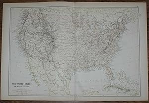
Softcover. Condizione: Very Good. No Dust Jacket. Early Edition. Disbound map from the 1884 "Comprehensive Atlas & Geography of the World: Comprising an Extensive Series of Maps, a Description, Physical and Political, of all the Countries of the Earth; a Pronouncing Vocabulary of Geographical Names, and a Copious Index of Geogra…phical Positions. Compiled and Engraved from the Most Authentic Sources, Under the Supervision of W. G. Blackie, PhD., F.S.A.Scot." Sheet number covers Single sheet with horizontal centre fold. Sheet is clean but slightly darkened at the edges. Map is drawn to a given scale with latitude and longitude lines, map is extensively labeled. Pastel shades have been used to denote countries and slightly darker shades have been used to denote boarders. Black and white engraved hatching shows landscape features. Size: 56x38cm. Item Type: Map. No dust jacket, as published. Single sheet map/chart which is suitable for framing. Illustrator: Drawn and Engraved by J. Bartholomew. Quantity Available: 1. Shipped Weight: under 1 kg. Pictures of this item not already displayed here available upon request. Inventory No: 45117104005. All our books are sent by tracked mail. Drawn and Engraved by J. Bartholomew (illustratore).
 Altre immagini
Editore: Blackie & Son, London, Glasgow, Edinburgh and Dublin 1884
- Brossura
- Mappa
Da: Bailgate Books Ltd, Doncaster, , Regno UnitoBailgate Books Ltd
Contatta il venditoreVenditore con 5 stelleCondizione: Usato - Molto buono
EUR 20,96
EUR 16,77 spedizioneSpedito da Regno Unito a U.S.A.Quantità: 1 disponibili
Softcover. Condizione: Very Good. No Dust Jacket. Early Edition. Disbound map from the 1884 "Comprehensive Atlas & Geography of the World: Comprising an Extensive Series of Maps, a Description, Physical and Political, of all the Countries of the Earth; a Pronouncing Vocabulary of Geographical Names, and a Copious Index of Geogra…phical Positions. Compiled and Engraved from the Most Authentic Sources, Under the Supervision of W. G. Blackie, PhD., F.S.A.Scot." Sheet number covers Single sheet with horizontal centre fold. Sheet is clean but slightly darkened at the edges. Map is drawn to a given scale with latitude and longitude lines, map is extensively labeled. Pastel shades have been used to denote countries and slightly darker shades have been used to denote boarders. Black and white engraved hatching shows landscape features. Size: 38x56cm. Item Type: Map. No dust jacket, as published. Single sheet map/chart which is suitable for framing. Illustrator: Drawn and Engraved by J. Bartholomew. Quantity Available: 1. Shipped Weight: under 1 kg. Pictures of this item not already displayed here available upon request. Inventory No: 45117104033. All our books are sent by tracked mail. Drawn and Engraved by J. Bartholomew (illustratore).
 Altre immagini
Editore: Blackie & Son, London, Glasgow, Edinburgh and Dublin 1884
- Brossura
- Mappa
Da: Bailgate Books Ltd, Doncaster, , Regno UnitoBailgate Books Ltd
Contatta il venditoreVenditore con 5 stelleCondizione: Usato - Molto buono
EUR 20,96
EUR 16,77 spedizioneSpedito da Regno Unito a U.S.A.Quantità: 1 disponibili
Softcover. Condizione: Very Good. No Dust Jacket. Early Edition. Disbound map from the 1884 "Comprehensive Atlas & Geography of the World: Comprising an Extensive Series of Maps, a Description, Physical and Political, of all the Countries of the Earth; a Pronouncing Vocabulary of Geographical Names, and a Copious Index of Geogra…phical Positions. Compiled and Engraved from the Most Authentic Sources, Under the Supervision of W. G. Blackie, PhD., F.S.A.Scot." Sheet number covers Single sheet with horizontal centre fold. Sheet is clean but slightly darkened at the edges. Map is drawn to a given scale with latitude and longitude lines, map is extensively labeled. Pastel shades have been used to denote countries and slightly darker shades have been used to denote boarders. Black and white engraved hatching shows landscape features. Size: 38x56cm. Item Type: Map. No dust jacket, as published. Single sheet map/chart which is suitable for framing. Illustrator: Drawn and Engraved by J. Bartholomew. Quantity Available: 1. Shipped Weight: under 1 kg. Pictures of this item not already displayed here available upon request. Inventory No: 45117104015. All our books are sent by tracked mail. Drawn and Engraved by J. Bartholomew (illustratore).
 Altre immagini
Editore: Blackie & Son, London, Glasgow, Edinburgh and Dublin 1884
- Brossura
- Mappa
Da: Bailgate Books Ltd, Doncaster, , Regno UnitoBailgate Books Ltd
Contatta il venditoreVenditore con 5 stelleCondizione: Usato - Molto buono
EUR 21,91
EUR 16,77 spedizioneSpedito da Regno Unito a U.S.A.Quantità: 1 disponibili
Softcover. Condizione: Very Good. No Dust Jacket. Early Edition. Disbound map from the 1884 "Comprehensive Atlas & Geography of the World: Comprising an Extensive Series of Maps, a Description, Physical and Political, of all the Countries of the Earth; a Pronouncing Vocabulary of Geographical Names, and a Copious Index of Geogra…phical Positions. Compiled and Engraved from the Most Authentic Sources, Under the Supervision of W. G. Blackie, PhD., F.S.A.Scot." Sheet number covers Single sheet with horizontal centre fold. Sheet is clean but slightly darkened at the edges. Map is drawn to a given scale with latitude and longitude lines, map is extensively labeled. Pastel shades have been used to denote countries and slightly darker shades have been used to denote boarders. Black and white engraved hatching shows landscape features. Size: 38x56cm. Item Type: Map. No dust jacket, as published. Single sheet map/chart which is suitable for framing. Illustrator: Drawn and Engraved by J. Bartholomew. Quantity Available: 1. Shipped Weight: under 1 kg. Pictures of this item not already displayed here available upon request. Inventory No: 45117104024. All our books are sent by tracked mail. Drawn and Engraved by J. Bartholomew (illustratore).

The Channel Islands; General Map of the Islands, Alderney & The Casquets, Guernsey and Sercq, Jersey
Editore: Published by A. Fullarton & Co [1860], London 1860
- Brossura
- Prima edizione
- Mappa
Da: Keoghs Books, Skipton, Regno UnitoKeoghs Books
Contatta il venditoreVenditore con 5 stelleCondizione: Usato
EUR 29,78
EUR 32,38 spedizioneSpedito da Regno Unito a U.S.A.Quantità: 1 disponibili
, 4 maps on one sheet, folded at centre, hand-coloured in outline, diferent scales for each of the 4 maps First Edition , some light spots at margins, maps clean, neat edge repair, in good+ condition 35 x 26.5 cm Paperback ISBN.
 Altre immagini
Editore: A & C BLACK, EDINBURGH CIRCA 1850's 1850
- Mappa
Da: Elder Books, Ross on Wye, Herefordshire, Regno UnitoElder Books
Contatta il venditoreVenditore con 5 stelleCondizione: Usato - Molto buono
EUR 71,46
EUR 13,82 spedizioneSpedito da Regno Unito a U.S.A.Quantità: 1 disponibili
No Binding. Condizione: Very Good. AN ORIGINAL MID 19th CENTURY MAP WITH EARLY HAND COLOURING, BLANK REVERSE ON MAP. MAP MEASURES APPROX 24 X 17 INCHES. HORIZONTAL FOLD TO MIDDLE OF MAP AS PUBLISHED WITH SLIGHT OFFSETTING FROM THE TEXT NORTH & SOUTH WALES UNDERNEATH, FEW MINOR CREASES & MINOR MARKS TO MAP, FEW MINOR CHIPS OR SMA…LL TEARS TO MARGINS. OVERALL THE MAP IS IN VERY GOOD CONDITION. PLEASE NOTE: THE CARD SURROUND MOUNT IN IMAGE IS FOR DISPLAY PURPOSES ONLY. EXTRA POSTAGE COSTS MAY APPLY TO OVERSEAS ORDERS. ALL ITEMS ARE POSTED IN STURDY BOX/TUBE.
 Altre immagini
Editore: published by Adam & Charles Black Ist October 1841, Edinburgh 1841
- Prima edizione
- Mappa
Da: Keoghs Books, Skipton, Regno UnitoKeoghs Books
Contatta il venditoreVenditore con 5 stelleCondizione: Usato
EUR 178,66
EUR 32,38 spedizioneSpedito da Regno Unito a U.S.A.Quantità: 1 disponibili
, small cloth bound folder with 2 folding, engraved maps fixed inside Plan of Edinburgh 15 x 19 cm and environs of Edinburgh 16 x 20 cm, delightful dedication in neat script on rear of Environs map - to Mrs. Fisher that she may direct her steps aright in town or country First Edition , cloth of covers shows the slightest rubbing…, maps in fine condition with a personal inscription adding to the charm of the whole - a very nice item , brown cloth covers with gilt title in thisle garland surmounted by an anchor , 10.3 x 7 cm folded map in hardcovers ISBN.


