Bascom stose (7 risultati)

Editore: Government Printing Office, Washington 1931
- Brossura
Da: Crossroads Books, Reno, NV, U.S.A.Crossroads Books
Contatta il venditoreVenditore con 5 stelleCondizione: Usato - Buono
EUR 14,13
EUR 4,40 spedizioneSpedito in U.S.A.Quantità: 1 disponibili
Condizione: good. from the introduction, "The Quakertown and Doylestown quadrangles, in this bulletin called the Quakertown-Doylestown district, lie mainly between the Delaware and Schuylkill Rivers, in southeastern Pennsylvania, north of Philadelphia; the northeast Pennsylvania, north of Philadelphia; the northeast corner of th…e Doylestown quadrangle, inclosed by the Delaware River, embraces a small portion of western New Jersey northwest of Trenton." DC6. softcover, 9" x 6", cover torn along spine top & bottom rear, foldout inside rear cover, 59 pages.

Editore: U. S. Geological Survey, 1932 1932
- Brossura
Da: Blue Heron Books, Claremont, CA, U.S.A.Blue Heron Books
Contatta il venditoreVenditore con 5 stelleCondizione: Usato - Molto buono
EUR 22,44
EUR 4,79 spedizioneSpedito in U.S.A.Quantità: 1 disponibili
Soft cover. Condizione: VG. VG. 18" x 22" folio. Department of Interior/ W. C. Mendenhall, Director. Contains Descriptive Text, Topographic Map, Areal Geology Map 15 p. + maps.
 Altre immagini
Editore: United States Geological Survey [USGS], Washington, DC 1929
- Brossura
- Prima edizione
Da: Robert Gavora, Fine & Rare Books, ABAA, Talent, OR, U.S.A.Robert Gavora, Fine & Rare Books, ABAA
Contatta il venditoreVenditore con 5 stelleCondizione: Usato - Molto buono
EUR 40,39
EUR 6,10 spedizioneSpedito in U.S.A.Quantità: 1 disponibili
Large folio. Condizione: Very Good. First edition. Printed wrappers. Twentey-two pages with "Description of the Fairfield and Gettysburg Quadrangles," with two pages of "Geologic Atlas of the United States," four double-page fine and bright maps showing, besides geologic features, roads, railroads and towns, three pages of photo…graphs, and one page of Columnar Sections. 1x2.5 inch moisture stain at the bottom corner of most pages, not affecting text or maps. Remains a very good copy. Atlas.
Editore: United States Geological Survey [USGS], Washington, DC 1932
- Brossura
- Prima edizione
Da: Robert Gavora, Fine & Rare Books, ABAA, Talent, OR, U.S.A.Robert Gavora, Fine & Rare Books, ABAA
Contatta il venditoreVenditore con 5 stelleCondizione: Usato - Molto buono
EUR 40,39
EUR 6,10 spedizioneSpedito in U.S.A.Quantità: 1 disponibili
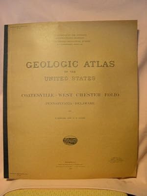
Large folio. Condizione: Very Good. First edition. Printed wrappers. Fifteen pages with "Description of the Coatesville-West Chester Quadrangles," with two pages of "Geologic Atlas of the United States," three double-page fine and bright maps showing, besides geologic features, roads, railroads and towns, one page of photographs…, and one page of Columnar Sections. Stamp of Congressman Sam L. Collins on the front cover. Tiny tears to the final few pages. A very good copy. Atlas.
Editore: Government Printing Office, Washington 1931
- Brossura
- Prima edizione
Da: HJP VERSANDBUCHHANDLUNG, WEDEL, SH, GermaniaHJP VERSANDBUCHHANDLUNG
Contatta il venditoreVenditore con 2 stelleCondizione: Usato - Molto buono
EUR 17,75
EUR 29,50 spedizioneSpedito da Germania a U.S.A.Quantità: 1 disponibili
Paperback. Condizione: Good. 1st Edition. 62 p. BULLETIN OF THE UNITED STATES GEOLOGICAL SURVEY ; 828. Fold-out maps at rear-pocket.
Editore: Government Printing Office, Washington 1938
- Brossura
- Prima edizione
Da: HJP VERSANDBUCHHANDLUNG, WEDEL, SH, GermaniaHJP VERSANDBUCHHANDLUNG
Contatta il venditoreVenditore con 2 stelleCondizione: Usato - Molto buono
EUR 29,75
EUR 29,50 spedizioneSpedito da Germania a U.S.A.Quantità: 1 disponibili
Paperback. Condizione: Good. 1st Edition. 145 p. Includes fold-out map(s) at rear-pocket. [BULLETIN OF THE UNITED STATES GEOLOGICAL SURVEY ; 891].
Editore: United States Geological Survey, Washington D.C. 1929
Da: Studio Bibliografico Malombra, Vicenza, VI, ItaliaStudio Bibliografico Malombra
Contatta il venditoreVenditore con 5 stelleCondizione: Usato
EUR 35,00
EUR 42,00 spedizioneSpedito da Italia a U.S.A.Quantità: 1 disponibili
22 pagine di testo, 12 pagine di tavole di mappe a colori, anche a doppia pagina, e foto in nero f.t. (color maps); 55 x 47 cm. Brossura editoriale con dorso in tela (paperback). Copertina leggermente ingiallita, molto buono internamente (very good). Etichetta e timbro di biblioteca estinta in copertina.


