Importo totale (1 articolo articoli):
Destinazione ordine:

clason map company (30 risultati)
Vai alla pagina principale dei risultati di ricerca
Filtri di ricerca
Tipo di articolo
- Tutti i tipi di prodotto
- Libri (26)
- Riviste e Giornali (Nessun altro risultato corrispondente a questo perfezionamento)
- Fumetti (Nessun altro risultato corrispondente a questo perfezionamento)
- Spartiti (Nessun altro risultato corrispondente a questo perfezionamento)
- Arte, Stampe e Poster (Nessun altro risultato corrispondente a questo perfezionamento)
- Fotografie (Nessun altro risultato corrispondente a questo perfezionamento)
- Mappe (4)
- Manoscritti e Collezionismo cartaceo (Nessun altro risultato corrispondente a questo perfezionamento)
Condizioni Maggiori informazioni
- Nuovo (Nessun altro risultato corrispondente a questo perfezionamento)
- Come nuovo, Ottimo o Quasi ottimo (12)
- Molto buono o Buono (11)
- Discreto o Mediocre (1)
- Come descritto (6)
Legatura
- Tutte
- Rilegato (Nessun altro risultato corrispondente a questo perfezionamento)
- Brossura (4)
Ulteriori caratteristiche
- Prima ed. (Nessun altro risultato corrispondente a questo perfezionamento)
- Copia autograf. (Nessun altro risultato corrispondente a questo perfezionamento)
- Sovracoperta (Nessun altro risultato corrispondente a questo perfezionamento)
- Con foto (28)
- Non Print on Demand (30)
Lingua (2)
Prezzo
- Qualsiasi prezzo
- Inferiore a EUR 20 (Nessun altro risultato corrispondente a questo perfezionamento)
- EUR 20 a EUR 45
- Superiore a EUR 45
Spedizione gratuita
- Spedizione gratuita in U.S.A. (Nessun altro risultato corrispondente a questo perfezionamento)
Paese del venditore
Valutazione venditore
-

Clason's Wisconsin Green Guide With Road And Railway Maps
Lingua: Inglese
Editore: Clason Map Co, Chicago
Da: Wabash Museum Books, Mount Carmel, IL, U.S.A.
Valutazione del venditore 5 su 5 stelle

Soft cover. Condizione: Fair. No Jacket. 47 Pages; Staple Binding; Pages Tight; Yellowed; Moderate Page Wear; No Markings On Pages. Faded Green Soft Covers With Border And Black Lettering And Illustration On Covers. Wear On Spine Ends, Edges; Some Rubbing. No Date But Cir 1920'S. Contains Information On State And City Maps; Auto Road Logs; Railroads; Commercial Index Of Towns Giving Hotels, Industries, Altitudes, Population, Etc. Many Maps And Image Of State Capitol At Madison. Sections On: Auto Road Section; Cities And Towns; Counties; Educational Institutions; Lakes; Hotels, Madison Map; Milwaukee Maps; Railroads; Rivers; State Institutions. Rear Page Provides Chard Of The Shortest Railroad Mileage Between Wisconsin Towns. Very Rare Vintage Copy.
-
Clason's Midget Map of Kansas [1918]
Editore: Clason Map Company, 1918
Da: Live Oak Booksellers, Langley, WA, U.S.A.
Valutazione del venditore 4 su 5 stelle

Mappa
No Binding. Condizione: Very Good. 13 x 7" map printed in color on one side that folds to about 2 x 3" and fits into a stiff card folder printed in blue. Front panel of card folder has the following information: "Compliments of F.M. Luther & Sons Brokers, Cimarron, Kansas." Map is in near fine condition with one short separation closed with archival repair and no markings. Card stock folder slightly worn and slightly soiled. The Clason Map Company operated in Denver from the early 1900s until the Depression. It published numerous maps in different forms, including a "midget map" series. The distributor of this map, F. M. Luther & Sons, was a real estate brokerage headed by Francis [Frank] Luther, one of the founders of Cimarron, Kansas. I dated this map using a couple of named Kansas highways. The Carrie Nation Highway was established in 1917 and is shown on this map; but this map lacks a "Victory Highway" which was designated ca. 1921. A relatively rare map of Kansas.
-
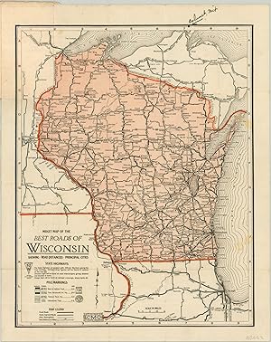
Midget Road Map of Wisconsin - Roads of Wisconsin during the early 1920s.
Editore: c. 1924, 1924
Da: Curtis Wright Maps, Berwyn, IL, U.S.A.
Membro dell'associazione: ESA MWABA
Valutazione del venditore 4 su 5 stelle
Condizione: Very Good. This handy little pocket map highlights in red the primary automobile routes that serve the state of Wisconsin (plus portions of northern Illinois and the Upper Peninsula). Labeled towns, railroads, and major geographic features make for a somewhat cluttered image. Several named trails are shown, including Sheridan Road (along Chicago's North Shore), the Yellowstone Trail, and the Great White Way. Copyrighted and published by the Clason Map Company around 1924 (after the firm had expanded to Chicago). By that point, it was somewhat outdated; Wisconsin adopted a numbered highway system in 1918, the first state to do so. The original covers indicate this example was distributed courtesy of Meglard Monument Works of Sparta, Wisconsin. Sheet Width (in) 9 Sheet Height (in) 12 Condition Description Small pocket map folded into original stiff paper wraps. Heavy dampstaining on the covers affects the upper portion of the map, with some splits along folds (repaired on verso) and staining as a result.
-
Clason's Double Indexed Map of Chicago - The Chicago of Al Capone.
Editore: c. 1926, 1926
Da: Curtis Wright Maps, Berwyn, IL, U.S.A.
Membro dell'associazione: ESA MWABA
Valutazione del venditore 4 su 5 stelle
Condizione: Very Good. This interesting map of Chicago, Illinois was published locally by the Clason Map Company around 1926, based on the presence of Soldier Field and the absence of any reference to Midway Airport. It provides a detailed look at the Windy City during the Roaring 20s, when Al Capone was at his height, jazz music blared, and speakeasies flourished with bootleg booze. The image presents a complex network of transportation routes - streets, electric & steam railroads, streetcar lines, and the iconic elevated lines, known affectionately as the 'L'. Neighborhoods, parks, and cemeteries are labeled, along with unique locations of interest like the Aero Club of Illinois, Union Stockyards, Hawthorne Race Track, and the tuberculosis sanitarium. Also of interest is the outline of proposed developments along the lakefront. A nearby inset in the center-right shows the Chicago Loop (the business district), while the borders provide street numbering information and an alphabetical street index. Handwritten annotations note the location of Theo. Ebert & Co. (a decorating and design company) on the north and west sides of the city. Sheet Width (in) 22 Sheet Height (in) 34 Condition Description Large pocket map folded into 30 panels and disbound from original paper wraps (present). Toning in the upper left panels and moderate wear along folds. Old manuscript annotations in pen. Good condition overall. Blank on verso.
-
CLASON'S NEVADA GREEN GUIDE
Editore: The Clason Map Company, n. d. (ca 1920)., Chicago, Denver, 1920
Da: BUCKINGHAM BOOKS, ABAA, ILAB, IOBA, GREENCASTLE, PA, U.S.A.
Membro dell'associazione: ABAA ILAB IOBA RMABA TXBA
Valutazione del venditore 4 su 5 stelle
[NEVADA]. 6 1/4" x 4" green pictorial stiff wrappers printed in black,16 pp., index to Nevada towns, state and city maps, automobile road logs, railroads, hotels, industries, altitudes, population, etc. A fold-out map at the front presents a mileage map of the transcontinental trails of the United States on one side and on the other side a mileage map of the best roads of California and Nevada. Affixed to the rear cover is a color map of Nevada. Both maps are in fine condition. Covers lightly used and rubbed , else a very good copy with light wear to the spine ends and corners.
-
INDEX TO MAP OF UTAH
Editore: The Clason Map Company, 1911., Denver, 1911
Da: BUCKINGHAM BOOKS, ABAA, ILAB, IOBA, GREENCASTLE, PA, U.S.A.
Membro dell'associazione: ABAA ILAB IOBA RMABA TXBA
Valutazione del venditore 5 su 5 stelle
[UTAH]. 6 1/4" x 4" green pictorial stiff wrappers printed in black, 32 pp., index to Utah towns, rivers and creeks, mountains and peaks, valleys and deserts, lakes, plus railroad distances and railroad distances between Utah towns. The color fold-out map of Utah is bight and and colorful. 3" closed split to lower edge of map at fold as well as 1/2" closed split to top edge of map at fold. Folder is clean and tight.
-
Easy Fold Maps of California Highways
Editore: Clason Map Company, 1920
Da: Barry Lawrence Ruderman, La Jolla, CA, U.S.A.
Membro dell'associazione: ABAA ILAB
Valutazione del venditore 5 su 5 stelle
Mappa
No Binding. Condizione: VG. Clason Map Company / 1920 / Easy Fold Maps of California Highways (Box 27, 73977) Folding map. Covers somewhat toned and worn. Early California road atlas, published by Edward Doheny's California Petroleum Corporation. Includes 4 larger road maps of sections of California and smaller city maps of major cities, including Los Angeles, San Diego, Long Beach, San Francisco, Oakland, San Jose, Santa Barbara, Sacramento, Fresno, and the East Bay. Map.
-
Seeing Chicago the Motor Coach Way - " "Open Air to Everywhere" along the lines of the Chicago Motor Coach Company."
Editore: c. 1923, 1923
Da: Curtis Wright Maps, Berwyn, IL, U.S.A.
Membro dell'associazione: ESA MWABA
Valutazione del venditore 4 su 5 stelle
Condizione: Fine. This interesting pocket map and tour guide to Chicago was published around 1923 by the Clason Map Company. It was distributed as a promotional item on behalf of the Chicago Motor Coach Company, which operated bus tours on three routes across the North, West, and South Sides of the Windy City. These are shown in brown, green, and orange, respectively, in the simple street plan of the city in the upper left. Nearly 80 points of interest - parks, beaches, hotels, and more - are numbered and identified in the adjacent list. Competing transit options like the elevated railway and streetcar lines are omitted from the image. The lower portion of the sheet is occupied by an overview of the Shopping District Service, including a Shopper's Map of the Loop that names many of the city's major merchants. The verso provides several small photographs and descriptive text of major attractions along each of the three tours. Discussion on the ongoing construction of Tribune Tower helps to date the map conclusively between 1923 and 1925. Sheet Width (in) 11.5 Sheet Height (in) 18 Condition Description Pocket map folded into 16 panels and affixed to original stiff paper wraps, as issued. Light wear along fold, including small pinholes at seam intersections. Near fine condition overall.
-
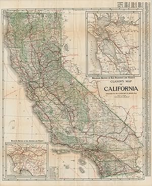
Clason's Map of California - California's roads in the midst of the Roaring '20s.
Editore: c. 1924, 1924
Da: Curtis Wright Maps, Berwyn, IL, U.S.A.
Membro dell'associazione: ESA MWABA
Valutazione del venditore 4 su 5 stelle
Condizione: Very Good. This fabulously detailed road map of California shows the burgeoning transportation network across the state in the mid-1920s. Main roads predate the numbered highway system and are individually labeled, like the Roosevelt National Trail, El Camino Real, and Pike's Peak Ocean to Ocean Highway. The various paths were undoubtedly surfaced with a variety of materials like macadam, gravel, dirt, and tar - there's even a wooden 'planked road' across the desert of Imperial County. Inset maps of the San Francisco and Los Angeles areas can be seen in the upper right and lower left, respectively. Published around 1924 in Denver by the Clason Map Company. Includes the accompanying guidebook, which presents more detailed street plans of California urban centers and an extensive index of cities and towns. Sheet Width (in) 27.5 Sheet Height (in) 33.75 Condition Description Originally issued folded into 48 panels, now separated from accompanying guidebook (64 pp., still present) and flattened. Former separation at fold intersections has been repaired on the verso, along with a few small edge tears. Minor discoloration and light offsetting visible in a few places, but overall the map and book both remain in good condition.
-
Clason's Chicago Street and Transportation Guide - " "The quickest way from where you are to where you want to go!" "
Editore: c. 1920, 1920
Da: Curtis Wright Maps, Berwyn, IL, U.S.A.
Membro dell'associazione: ESA MWABA
Valutazione del venditore 4 su 5 stelle
Condizione: Very Good. "The detailed guidebook to Chicago was published locally around 1920 by the Clason Map Company. Its 96 pages include a wealth of contemporary information about the Second City and provides a comprehensive street index, information on accommodations, transportation details, and a number of single-page plans covering the various suburbs. Accompanying the guidebook is a large folding map of the city, with its outlines in red and the forest preserves, parks, boulevards, and cemeteries highlighted in green. The Loop, Cubs & White Sox Ballparks, and the Union Stockyards, evidently four of the city's most vital economic areas, are also colored in red. Transportation routes are noted in great detail; including street names, railroads, and waterways. Various locations of interest are individually labeled, such as Grant Park Stadium (under construction), the Municipal Pier, and several buildings within the inset map of the Loop (center left). Surrounding the image is a border identifying Chicago's new street numbering system which was officially implemented about a decade prior to publication. Further information on the grid is available in the upper left. Dated using the presence of the Michigan Avenue Bridge (1920) and the absence of the Chicago Theater (opened in 1921). Source" Sheet Width (in) See Description Sheet Height (in) See Description Condition Description "96 pp. guidebook, approximately 4.25" x 7.5" , with stapled binding and illustrated paper covers. Wrappers are heavily soiled, but intact, and the contents are in good shape save for some light spotting and creased corners. Includes a fold-out map affixed to the inside of the back cover. Map measures approximately 24.75" x 33.9" and has a 6" tear in the upper left where adhered to the guidebook. Otherwise lightly creased, a few small edge tears, and slightly faded color. Good to very good overall.".
-

Clason's Around Lake Michigan Paved Road Map - Rare map of the early road network around Chicago.
Editore: c. 1924, 1924
Da: Curtis Wright Maps, Berwyn, IL, U.S.A.
Membro dell'associazione: ESA MWABA
Valutazione del venditore 4 su 5 stelle
Condizione: Very Good. This uncommon pocket map embraces the newfound freedom afforded by the increasing popularity of the automobile and the growing network of highways around Chicago. Eager motorists could travel to areas across Wisconsin, Illinois, Indiana, and Michigan - much of it accessible via paved roads. An inset of the Windy City, with Routes In and Out, is shown in the upper center. Distances between points are noted and a somewhat confusing variety of numbers and letters indicate specific routes. Prior to the introduction of the U.S. Numbered Highway System in 1926, auto trails were named and maintained independently by a variety of private and public organizations. Numerous examples, along with their respective sign markers, are listed in the lower right. The map was published around 1924 by the Clason Map Company of Chicago and Denver. The original covers indicate it was printed by the Standard Map Company and distributed compliments of Hotels Alexandria and Bradley (presumably owned by the same entity). Only one entry in WorldCat (at the University of Michigan) as of October 2025. OCLC# 35061617. Sheet Width (in) 16.25 Sheet Height (in) 13.1 Condition Description Single-sided pocket map folded into original stiff brown paper wraps. Moderate wear along folds, including a bit of toning, small holes at joints, and creasing. Good condition overall.
-
Clason's Double Index Map Chicago wall map
Editore: Clason Map Co, Chicago, 1925
Da: mediumraremaps.com, Franklin, TN, U.S.A.
Valutazione del venditore 4 su 5 stelle
Mappa
32 1/2 x 22 3/4 inches. Beautifully composed black and White map of the city of Chicago in very good condition. From Evanston on the north to Riverdale on the south, the map captures the grid system of streeting. From Lake Michigan on the east to Berwyn on the west side, the immensity of order set by the street makes the thought of travel a simple task. This map tells you where your at and all the right angle turns you will make to reach your destination. This is a highly colorable map. Very good but having several separations at the folds. The map is still attached to the cover.
-

Mileage Map of the Best Roads of Florida - The roads of Florida during the mid-1920s.
Editore: c. 1925, 1925
Da: Curtis Wright Maps, Berwyn, IL, U.S.A.
Membro dell'associazione: ESA MWABA
Valutazione del venditore 4 su 5 stelle
Condizione: Fine. "This scarce and early road map of Florida was published by the Clason Map Company around 1925. At the time, the network of paved routes was in its relative infancy, and only 'best roads' and 'other thoroughfares' are noted with solid and empty lines, respectively. Numbered state highways (introduced in 1923) are shown in small blue boxes. Additional highways, historic routes, and sponsored trails were posted on utility poles - their respective markings are shown in the center left. Notable examples include the Dixie Highway, the Old Spanish Trail, and the Atlantic Highway. An index of cities, each with its estimated population, is provided at the bottom of the pocket map. The inside of the front covers (titled Pleasant Journeys) offers an advertisement for Orwin Manor, the 'Million Dollar Development of Orlando and Winter Park'. The subdivision, owned by the Central Florida Development Company, began selling parcels in 1924 (in the midst of the Florida Land Boom) and remains a distinctive historic neighborhood in Orlando. A handwritten note reads " why not motor down here - fine roads - 7 day trip - Mary." Sources: Michigan State University Library; Orwin Manor" Sheet Width (in) 12.25 Sheet Height (in) 16.3 Condition Description Single-sided color printed map on a folded sheet, affixed to original stiff paper wraps. Lightly wrinkled along folds, with an irregular curl in the left margin. Handwritten note on the faintly worn covers. Very good condition overall. Handwritten note in black ink on the faintly worn covers.
-

E.E. Baldwin Map of the Chicago Loop - Ephemeral map of downtown Chicago published shortly after Capone's takeover of the Outfit.
Editore: c. 1926, 1926
Da: Curtis Wright Maps, Berwyn, IL, U.S.A.
Membro dell'associazione: ESA MWABA
Valutazione del venditore 4 su 5 stelle
This eminently practical map of downtown Chicago was published locally by the Clason Map Company and distributed by the real estate firm of E.E. Baldwin. Baldwin was apparently trying to capitalize on the rapidly growing trend of automobile ownership, as the verso of the sheet provides extensive information on local parking regulations, traffic laws, and through streets. Minors under the age of fifteen are not allowed to drive! The primary image provides a detailed, large-scale overview of the Loop, noting important structures, transportation depots, and other major features. Lists of hotels, train stations, theaters, and principal buildings offer helpful references, with a blank area at the bottom for handwritten memoranda. The map is undated, though the presence of the Palmer House and Union Station (both opened in 1925) and the lack of the Stevens Hotel (opened in 1927 as the largest in the country) indicates a likely date of issue around 1926. That same year, the Chicago Coliseum (noted at the bottom of the page) hosted the Blackhawks' first season. Al Capone, recently named head of the Chicago Outfit by Joe Torrio, would get his hair cut at the Blackstone Hotel along Michigan Avenue. Condition B+ Condition Description Formerly folded pocket map (printed on both sides) lacking original covers, with a small hole in the upper left corner that effects the title and area adjacent. Worn along old folds and moderately soiled in several areas. Numerous small tears along the outer edges of the sheet do not affect the image. Good condition overall.
-
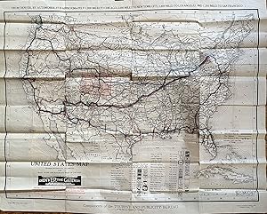
United States Map Transcontinental Highways and Main Trunk Line Railroads West of Chicago
Editore: Clason Map Company: Compliments of the Tourist and Publicity Bureau of the Denver Chamber of Commerce, Denver, 1920
Da: mediumraremaps.com, Franklin, TN, U.S.A.
Valutazione del venditore 4 su 5 stelle
Mappa
This is a superb cartographic artifact from the early years of automobile travel. The map is unusual in its large scale. Clason maps are generally a much smaller scale and usually state-centric. This map is rare with WorldCat locating two editions with a total of four copies. This map was used by a well travelled person. The user followed the trail system and marked the routes with blue and red markings. The pre-Federal highway numbering system of Trails dominates the map. The user travelled some trails more than once. Most prominent is the use of the National Old Trails road which was the predecessor to Route 66. Route 66 was introduced in 1926. The National Old Trails road was also known as the Coast-to-Coast highway. The road ran from Baltimore MD to Santa Monica, CA. This map's user travelled the most parts of the road. The Old Spanish Trail was traversed from St Augustine to San Diego. Red markings indicate the portions traveled each day. Multiple other trails were used as listed in the Trails index on the map, including the Oregon Trail.This map is a critical document in the history of transportation. It freezes a time where the consciousness of the traveling public had expanded and opened to the concept of transcontinental travel by car. The map's user chronicled that travel and the journeys are here recorded. The map is undated but WorldCat shows 1920 for the other non-Denver edition. This would be the same or only slightly thereafter. The period precedes heavy Federal involvement with the consciousness of long distance travel by car in its infancy. This is a rarity and an exception period documentation of the road well travelled. Good condition having been used as a travel document. Some tears at the fold intersection and overall mild soiling. The tears have been repaired with archival mending tape. Single sheet Wall Map measuring 32 x 26 inches WorldCat lists two editions with only four total locations found.
-
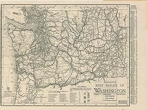
Mileage Map of the Best Roads of Washington - Mid-1920s road map of Washington issued by a prominent regional auto supply company.
Data di pubblicazione: 1925
Da: Curtis Wright Maps, Berwyn, IL, U.S.A.
Membro dell'associazione: ESA MWABA
Valutazione del venditore 4 su 5 stelle
Condizione: Fine. "This detailed motor map of Washington State was published in 1925 by the Clason Map Company and distributed by Western Auto Supply So., according to the bold advertisements on the covers. Originally founded as a mail-order business for replacement automobile parts in Kansas City in 1909 (the year after the Model T was introduced) the first Western Auto retail store didn't open until 1921. Within a few short years, the number of establishments grew to over 100, operating primarily on the West Coast. The map highlights the paved roads, through routes, and other thoroughfares across the state. The inclusion of both pole markings (for auto trails) and numbered state highways reflect the conflicting system of roadway identification that was endemic until the widespread adoption of the U.S. Numbered Highway System (1926). An index of cities and their respective populations can be found on the left and right sides. The verso presents a simple map of the roads around the Puget Sound region, with connections shown to Mt. Rainier National Park. Source. " Sheet Width (in) 17.6 Sheet Height (in) 11.6 Condition Description Double-sided pocket map folded into 16 segments and affixed to original illustrated stiff paper wraps. Light wear and creasing on the map and covers, but remains in very good condition overall.
-
Midget Map of the Best Roads in Wisconsin - The Clason Map Company's first road map of Wisconsin.
Data di pubblicazione: 1923
Da: Curtis Wright Maps, Berwyn, IL, U.S.A.
Membro dell'associazione: ESA MWABA
Valutazione del venditore 4 su 5 stelle
Condizione: Very Good. "This 'Midget' road map (indicating it's smaller than the regular issue) was published by the Clason Map Company in 1923. Early trail and highway markers are noted in the lower left corner, and the road legend identifies paved roads, highly improved roads, and other thoroughfares. Based on the stamp on the inside front cover (helpfully identified as a Christmas 'Brownie'), the pocket map was distributed as a holiday giveaway by the Schuster's Department store in Milwaukee. Source." Sheet Width (in) 9 Sheet Height (in) 11.3 Condition Description Moderate wear along original fold lines and three small spots visible on the right side of the sheet. Manuscript writing on the top margin identifies Calumet, Michigan. Original pictorial paper covers are attached and in good shape, but worn.
-
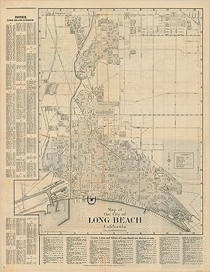
Map of the City of Long Beach California - The streets of LBC decades before Snoop, Nate Dogg, and Warren G.
Data di pubblicazione: 1930
Da: Curtis Wright Maps, Berwyn, IL, U.S.A.
Membro dell'associazione: ESA MWABA
Valutazione del venditore 4 su 5 stelle
Condizione: Very Good. At the time this street map was published, Long Beach, California was an oil town and booming coastal city, as well as a popular seaside resort. Golf courses, parks, and other recreational facilities are shown alongside airfields, piers, transportation routes, and other elements highlighting the city's industrial prowess. A comprehensive street index can be found on the left and bottom of the sheet, while the verso includes a road map of Southern California and a photographic panorama of the Long Beach skyline. The map was created by the Clason Map Company in 1930 and printed in Long Beach by Green's Inc. Sheet Width (in) 16.75 Sheet Height (in) 21.6 Condition Description Sheet is moderately toned and worn, consistent with age. Creasing along originally issued fold lines and slight discoloration along the vertical centerfold. Front panels of the brochure (verso) are discolored, but it does not affect the image.
-
Hotel Rosslyn [Los Angeles] - " "Meet us in the heart of Los Angeles" "
Data di pubblicazione: 1915
Da: Curtis Wright Maps, Berwyn, IL, U.S.A.
Membro dell'associazione: ESA MWABA
Valutazione del venditore 4 su 5 stelle
Condizione: Fine. "This ephemeral promotional brochure was distributed in 1915 to advertise Hotel Rosslyn in Los Angeles - built the year prior for the mind-boggling sum of one million dollars. Billed as " the Largest Popular Priced Hotel on the Pacific Coast" , the massive structure had nearly 800 rooms with rates ranging from $2 - $7/night. A centerfold map designed by the Clason Map Company shows greater Los Angeles, with red overprinting noting boulevards across the area. Numerous regional destinations are listed, along with their respective distances from the hotel (marked with a star). The heart symbol is featured prominently throughout the piece - a nod to the Hart Brothers owners, who also owned the Natick House down the street. Hotel Rosslyn still stands in L.A.'s downtown and was listed on the National Register of Historic Places in 2013. Further Reading, including the Hotel Rosslyn's spooky past: LA Times; LA Mag; LA Conservancy;" Sheet Width (in) 11.9 Sheet Height (in) 9 Condition Description Tri-fold brochure with light toning along folds and faint wear along the outer edges of the sheet. Very good condition overall.
-
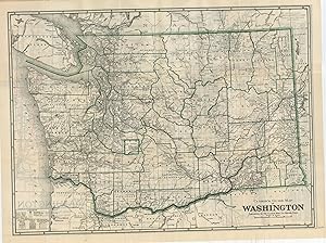
Clason's Washington Green Guide - The final edition of Clason's Green Guide to Washington.
Data di pubblicazione: 1931
Da: Curtis Wright Maps, Berwyn, IL, U.S.A.
Membro dell'associazione: ESA MWABA
Valutazione del venditore 4 su 5 stelle
Condizione: Fine. "According to some incredible research by Carl Liedholm of Michigan State University, the Clason Map Company of Denver, Colorado first started creating pocket guides in 1906, three years after its earliest maps were issued. These were focused on the cities of Denver and Colorado Springs, but would eventually broaden to encompass entire states. In 1908, the iconic green covers were introduced, and in 1920 the name 'Green Guide' was formally adopted. Liedholm states " The Green Guides were a unique product of the Clason Map Company. They were pocket-sized (approximately 4" x 6" ) guides that were published for many states and several cities. Each guide consisted of a booklet, ranging in length from 15 to over 60 pages with detailed information about the state or city, and one or more large maps that were pasted within the covers. Each of the state guides included a commercial index of the cities and towns that provided information on their individual populations, elevations, industries, hotels, and banks. In addition, there was general information about the state that would be of interest to the traveler on such topics as state history, scenic wonders, national parks, roads, railways, and " interesting facts about the state." Downtown city maps and pictures were incorporated into the textual descriptions." This is a fine example of the 1931 edition of Clason's Green Guide of Washington, the last year the company published the guidebooks. A double-sided folding map shows the transportation network, system of land surveying, National Forests, and Indian Reservations across the state. The verso focuses entirely on the road system, using a variety of lines to differentiate between surface composition and State and U.S. Highways. The guidebook includes a street plan of Seattle, Spokane, and Tacoma, large-scale maps of their business sections, and a photographic view of the capitol building at Olympia; in addition to the aforementioned generalized contents. Source. " Sheet Width (in) 23.6 Sheet Height (in) 16.9 Condition Description Folding map with creasing and faintly toned edges affixed to 24 pp. guidebook with illustrated stiff paper wraps. Contents are lightly discoloration around the edges and show faint wear, consistent with age and use. Very good to near fine overall.
-
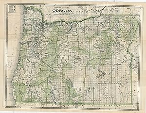
Clason's Oregon Green Guide - The final edition of Clason's Green Guide to Oregon
Data di pubblicazione: 1931
Da: Curtis Wright Maps, Berwyn, IL, U.S.A.
Membro dell'associazione: ESA MWABA
Valutazione del venditore 4 su 5 stelle
Condizione: Fine. "According to some incredible research by Carl Liedholm of Michigan State University, the Clason Map Company of Denver, Colorado first started creating pocket guides in 1906, three years after its earliest maps were issued. These were focused on the cities of Denver and Colorado Springs, but would eventually broaden to encompass entire states. In 1908, the iconic green covers were introduced, and in 1920 the name 'Green Guide' was formally adopted. Liedholm states " The Green Guides were a unique product of the Clason Map Company. They were pocket sized (approximately 4" x 6" ) guides that were published for many states and several cities. Each guide consisted of a booklet, ranging in length from 15 to over 60 pages with detailed information about the state or city, and one or more large maps that were pasted within the covers. Each of the state guides included a commercial index of the cities and towns that provided information on their individual populations, elevations, industries, hotels, and banks. In addition, there was general information about the state that would be of interest to the traveler on such topics as state history, scenic wonders, national parks, roads, railways, and " interesting facts about the state." Downtown city maps and pictures were incorporated into the textual descriptions." This is a fine example of the 1931 edition of Clason's Green Guide of Oregon, the last year the company published the guidebooks. A double-sided folding map shows highlights in green the vast territories of National Forests, Parks, and Reserves, along with a basic transportation overview of the state. The verso focuses entirely on the road system, using a variety of lines to differentiate between surface composition and State and U.S. Highways. The guidebook includes a street plan for Portland and its downtown district and a view of the capitol building at Salem, in addition to the aforementioned generalized contents. Source." Sheet Width (in) 23.75 Sheet Height (in) 17.5 Condition Description Folding map with light toning around the outer edges affixed to 16 pp. guidebook with illustrated stiff paper wraps. Contents show toning around the edges and light wear, but overall in very good to near fine condition.
-
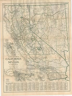
Clason's Nevada Green Guide - The final edition of Clason's Green Guide to Nevada.
Data di pubblicazione: 1931
Da: Curtis Wright Maps, Berwyn, IL, U.S.A.
Membro dell'associazione: ESA MWABA
Valutazione del venditore 4 su 5 stelle
Condizione: Fine. "According to some incredible research by Carl Liedholm of Michigan State University, the Clason Map Company of Denver, Colorado first started creating pocket guides in 1906, three years after its earliest maps were issued. These were focused on the cities of Denver and Colorado Springs, but would eventually broaden to encompass entire states. In 1908, the iconic green covers were introduced, and in 1920 the name 'Green Guide' was formally adopted. Liedholm states " The Green Guides were a unique product of the Clason Map Company. They were pocket sized (approximately 4" x 6" ) guides that were published for many states and several cities. Each guide consisted of a booklet, ranging in length from 15 to over 60 pages with detailed information about the state or city, and one or more large maps that were pasted within the covers. Each of the state guides included a commercial index of the cities and towns that provided information on their individual populations, elevations, industries, hotels, and banks. In addition, there was general information about the state that would be of interest to the traveler on such topics as state history, scenic wonders, national parks, roads, railways, and " interesting facts about the state." Downtown city maps and pictures were incorporated into the textual descriptions." This is a fine example of the 1931 edition of Clason's Green Guide of Nevada, the last year the company published the guidebooks. A double-sided folding map of both California and Nevada shows a basic overview of both states with insets of San Diego, San Francisco, and Los Angeles. The verso focuses entirely on the road system, using a variety of lines to differentiate between surface composition and State and U.S. Highways. The guidebook includes a street plan of Reno and its downtown district and a view of the capitol building at Carson City, in addition to the aforementioned generalized contents. Source. " Sheet Width (in) 20.5 Sheet Height (in) 27.75 Condition Description Folding map with light toning around the outer edges affixed to 16 pp. guidebook with illustrated stiff paper wraps. Contents show toning around the edges and light wear, but overall in very good to near fine condition.
-
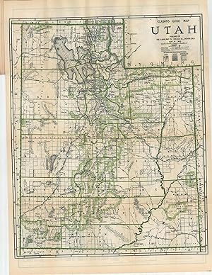
Clason's Utah Green Guide - The final edition of Clason's Green Guide to Utah
Data di pubblicazione: 1931
Da: Curtis Wright Maps, Berwyn, IL, U.S.A.
Membro dell'associazione: ESA MWABA
Valutazione del venditore 4 su 5 stelle
Condizione: Fine. "According to some incredible research by Carl Liedholm of Michigan State University, the Clason Map Company of Denver, Colorado first started creating pocket guides in 1906, three years after its earliest maps were issued. These were focused on the cities of Denver and Colorado Springs, but would eventually broaden to encompass entire states. In 1908, the iconic green covers were introduced, and in 1920 the name 'Green Guide' was formally adopted. Liedholm states " The Green Guides were a unique product of the Clason Map Company. They were pocket-sized (approximately 4" x 6" ) guides that were published for many states and several cities. Each guide consisted of a booklet, ranging in length from 15 to over 60 pages with detailed information about the state or city, and one or more large maps that were pasted within the covers. Each of the state guides included a commercial index of the cities and towns that provided information on their individual populations, elevations, industries, hotels, and banks. In addition, there was general information about the state that would be of interest to the traveler on such topics as state history, scenic wonders, national parks, roads, railways, and " interesting facts about the state." Downtown city maps and pictures were incorporated into the textual descriptions." This is a fine example of the 1931 edition of Clason's Green Guide of Utah, the last year the company published the guidebooks. A double-sided folding map shows the transportation network, system of land surveying, National Forests, and Indian Reservations across the state. The verso focuses entirely on the road system, using a variety of lines to differentiate between surface composition and State and U.S. Highways. The guidebook includes a street plan of Salt Lake City and Ogden, a large-scale plan of the business section, and a photographic view of the capitol building; in addition to the aforementioned generalized contents. Source." Sheet Width (in) 17.6 Sheet Height (in) 23.6 Condition Description Folding map with light toning around the outer edges affixed to 16 pp. guidebook with illustrated stiff paper wraps. Contents show toning around the edges and light wear, but overall in very good to near fine condition.
-
Map of Los Angeles - Dense street map of Los Angeles, California advertising for a local storage company.
Data di pubblicazione: 1926
Da: Curtis Wright Maps, Berwyn, IL, U.S.A.
Membro dell'associazione: ESA MWABA
Valutazione del venditore 4 su 5 stelle
Condizione: Fine. While nowhere near the sprawl that can be seen today, this 1920's street map of Los Angeles certainly gives an impression of the urban expansion that has helped to define the largest city in California. A detailed street index is provided along the top and bottom of the sheet, while the locations of Lyons Fireproof Storage Company buildings are noted with an arrow and two stars. Further advertisements can be seen on the verso, in which are offered specialized features like piano rooms, moving services, and of course, fireproof construction. An automobile road map of southern California is also provided - despite its date of 1926, the accompanying legend still identifies 'wagon roads' alongside modern means of transportation. Sheet Width (in) 21.9 Sheet Height (in) 27.9 Condition Description A bit of creasing and faint wear along originally issued fold lines, and minor soiling around the outer edges. Very good, or better, overall.
-
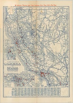
Clason's Road Map of California and Nevada - Double sided pocket map showing the roads in California and Nevada.
Data di pubblicazione: 1930
Da: Curtis Wright Maps, Berwyn, IL, U.S.A.
Membro dell'associazione: ESA MWABA
Valutazione del venditore 4 su 5 stelle
Condizione: Very Good. This detailed transportation map was published in 1930 by the Clason Map Company and shows the most up to date road information for motorists in Nevada and California. Three separate road surfaces are identified, along with distance markers and highway numbers according to the accompanying legend in the lower center. Inset maps of San Francisco and Los Angeles are provided in the lower left. Orange dots throughout highlight the location of West Auto Supply Company store locations, while a pictorial advertisement on the front cover shows a technician with a curiously long arm. The verso of the map shows a similar mileage map of the best roads throughout Central California. Sheet Width (in) 11.9 Sheet Height (in) 17 Condition Description Issued folded into 16 panels and affixed to original paper covers, which are present and in good condition. Heavy creasing and moderate wear along fold lines, including several areas of separation. A dark spot in the upper center of the image.
-
Mileage Map of the Best Roads of Florida - The 'death' of the Florida Land Boom (and independently named roads).
Data di pubblicazione: 1925
Da: Curtis Wright Maps, Berwyn, IL, U.S.A.
Membro dell'associazione: ESA MWABA
Valutazione del venditore 4 su 5 stelle
Condizione: Very Good. This uncommon pocket map of Florida was designed by the Clason Map Company of Denver in 1925, according to the calendar printed on the inside of the front cover (and MSU's guide to dating Clason maps). The paper wraps also advertise J.D. Baskin's real estate firm (located in Clearwater) and note the printers as U.O. Colson Company of Paris, Illinois - apparently, the piece was a nationwide effort! The centerfold image notes the state highways (established in 1923) and the various other named routes in operation across Florida. The latter group represents an interesting variety of private enterprises and state/municipal sponsorship. For example, the Bee-Line Highway opened in 1924 as a toll road to connect West Palm Beach to real estate developments on Lake Okeechobee. The introduction of a national numbered highway system in 1926 would make these private routes largely obsolete. The map also reflects another contemporary trend - the collapse of the Florida Land Boom. The completion of the Florida East Coast Railway (1912), rapid population growth, national economic prosperity, and the allure of a seaside paradise laid the foundation for a period of intense real estate speculation in Florida during the mid-1920s. However, a massive hurricane hit the state in 1926 and a subsequent railroad embargo on building materials crippled reconstruction, leading to a precipitous drop in prices that slowed development for over a decade. Sheet Width (in) 12.5 Sheet Height (in) 16.25 Condition Description Pocket map folded into 20 segments, as issued, and disbound from original stiff paper wraps (present). Creasing and moderate wear along fold lines, including small pinholes at fold intersections. A few scattered spots, the largest of which is just above the scale. Covers are moderately worn and soiled. Better than good, but not quite very good condition.
-
Map of Los Angeles City - Downtown Section - Los Angeles District Automobile Roads and other routes of travel - The City of Angels during the First World War.
Data di pubblicazione: 1918
Da: Curtis Wright Maps, Berwyn, IL, U.S.A.
Membro dell'associazione: ESA MWABA
Valutazione del venditore 4 su 5 stelle
Condizione: Fine. This fascinating 1918 pocket map of Los Angeles covers the metropolitan area during a period of immense change and development. America's recent entry into WWI saw L.A. become a massive center for shipbuilding, recruitment, aviation development, and 'Hollywood patriotism.' Tens of thousands of soldiers, workers, and their families poured into Southern California during the wartime years, prompting regional growth that would continue through the Depression and World War II. A fold-out map copyrighted by the Clason Map Company offers a large-scale view of the downtown district. Numerous important buildings are outlined and labeled, providing a detailed glimpse of a bygone era. The location of the Los Angeles Trust and Savings Bank, distributors of the piece, are highlighted in bright red. The verso of the sheet uses the same vibrant color to emphasize the primary auto routes throughout the Los Angeles region. The urban expansion is evident, with paved roads and lines of the Pacific Electric Railway stretching from San Fernando to Newport Beach. The map is affixed to the back cover of a small booklet that highlights L.A.'s recent successes while promoting the security offered by the Los Angeles Trust and Savings Bank. Eight double-sided pages include a list of civic achievements, office buildings, hotels, theaters, transportation offices, churches, hospitals, clubs, and nearby locations of interest. The last category includes Sawtelle, a community established around a large home for disabled veterans that became a popular tourist attraction (and was then engaged in a bitter annexation dispute with L.A.). A centerfold chart of parcel postal rates notes a 1-cent war tax. Sheet Width (in) 11 Sheet Height (in) 11 Condition Description Double-sided fold out map (size given) affixed to the back cover of a 16 pp. booklet with stapled binding and original yellow paper wraps. Map is sharply creased, but in near fine condition. The booklet shows a strip of toning along the upper margin and some rusting from the staples. Good to very good condition overall.
-
Clason's Colorado Hotel Guide and Commercial Index - Early 20th century guide to the railroads of Colorado.
Data di pubblicazione: 1909
Da: Curtis Wright Maps, Berwyn, IL, U.S.A.
Membro dell'associazione: ESA MWABA
Valutazione del venditore 4 su 5 stelle
Condizione: Fine. " George Clason is perhaps most well-known for his essays on economics and financial independence, as well as his 1926 book, The Richest Man in Babylon. After serving as a Civil Engineer in the Spanish-American War, Clason moved to Denver, Colorado, and found employment as a draughtsman for local patent attorneys, mostly involved in the mining industry. Clason began producing his own maps for commercial sale in 1902, and formed the Clason Map Company in 1904. Clason s business grew quickly, and by 1910 he had shifted from maps of Colorado to maps of western states beyond Colorado, as well as city maps of western metropolitan areas." - Osher Map Library. This is an early example of Clason's guidebook to Colorado, published in Denver in 1909 and distributed compliments of C.C. Kerr & Co., land agents operating in Monte Vista. Its 64 pages describe " the 180 best towns in Colorado. Giving resources population, elevation, railroads, and banks. WITH SPECIAL MENTION of the leading real estate dealers and best hotels." [Title Page]. Contemporary advertisements, facts & figures, passenger rates, and blank lines for memoranda are also included within the printed covers. Clason's Railroad Map of Colorado is affixed to the back, showing all the railways in operation throughout the state. Distances between stations are noted, and a mileage table on the back provides information on the intervals between towns. Source: Osher Map Library" Sheet Width (in) See Description Sheet Height (in) See Description Condition Description "64 pp. guidebook and index with stapled binding and original yellow stiff paper wraps. Includes a folding map, 13.75" x 10.75" , affixed to the back cover. Near fine condition overall, with faint wear consistent with age.".
-
Golf Map of Southern California - A rare 1922 Golf and Automobile Road Map of the Los Angeles District, courtesy of California Fireproof Storage Company.
Data di pubblicazione: 1923
Da: Curtis Wright Maps, Berwyn, IL, U.S.A.
Membro dell'associazione: ESA MWABA
Valutazione del venditore 4 su 5 stelle
Condizione: Fine. "Automobiles and golfing were both becoming increasingly popular throughout America during the 1920s, but these fads were glamorously celebrated and widely indulged in the two major coastal cities of New York and Los Angeles. With an ideal climate, wealthy residents, and plenty of space, the latter metropolis was primed to exploit the trend - membership in the Southern California Golf Association rose from less than 1,400 members in 1919 to around 20,000 by 1925. This map by the Clason Map Company, dated 1923, showcases Los Angeles at the start of the Roaring 20s. One side of the folding sheet presents a detailed street map of L.A. with an accompanying alphabetical index and instructions for use (lower right). Two locations of the California Fireproof Storage Company, sponsors of the map, are highlighted in green. Otherwise, only cemeteries, parks, and transportation depots are named. Sadl,y the iconic Hollywood sign, which was completed the same year as printing, is not labeled! The verso of the sheet presents a 'Golf and Automobile Road Map of Los Angeles District.' Twenty-six different courses are numbered within the image and listed in the lower left, with two others under construction and several more not shown. Additional panels of text and illustrations promote the California Fireproof Storage Company - " Service features to be found Nowhere Else!" The map is quite scarce and I've been unable to locate any market records or other recorded examples. Source: Southern California Golf Association " Sheet Width (in) 21.75 Sheet Height (in) 28 Condition Description Double-sided map folded into a pocket-sized mailer, with sharp creasing, moderate toning, and a few pin holes along the fold lines. Extraneous wrinkling visible throughout the sheet, though the image is not obfuscated, and lightly creased corners. Good to very good condition overall.
-

Kit Carson, Lincoln and Cheyenne Counties, Colorado
Data di pubblicazione: 1907
Da: Art Source International Inc., Boulder, CO, U.S.A.
Valutazione del venditore 5 su 5 stelle
At the turn of the century, the Clason Map Company was an up and coming publisher that was growing and doing some of their best work. This map is a fine example of their quality. With their trademark simplicity and clarity, the Clason Map Company provided well-detailed work, which remained legible and aesthetically appealing. This map shows detail for the hydrography, railways, and towns. This map of Kit Carson, Lincoln and Cheyenne Counties, Colorado shows Limon with distances to Colorado Springs and Denver. This map measure 32.5 inches by 27 Inches.

![Immagine del venditore per Clason's Midget Map of Kansas [1918] venduto da Live Oak Booksellers](https://pictures.abebooks.com/inventory/md/md30455518925.jpg)


![Immagine del venditore per Hotel Rosslyn [Los Angeles] - " "Meet us in the heart of Los Angeles" " venduto da Curtis Wright Maps](https://pictures.abebooks.com/inventory/md/md32071214747.jpg)