Diercke gaebler (35 risultati)

Editore: George Westermann, Braunschweig 1901
- Rilegato
Da: Willis Monie-Books, ABAA, Cooperstown, NY, U.S.A.Willis Monie-Books, ABAA
Contatta il venditoreVenditore con 5 stelleCondizione: Usato - Discreto
EUR 20,15
EUR 6,95 spedizioneSpedito in U.S.A.Quantità: 1 disponibili
Hardcover. Condizione: Fair. Corners are bumped, and heavily chipping. Hinges feel very loose, especially at the outside hinges. Front cover is curving upwards. Leather on most of the corners have rubbed away. Spine has heavy rubbind, and chipping, especially at the ends. Spine ends has some leather loss. Covers have heavy rubbi…ng. ; German text. Color illustrations.

Editore: Braunschweig, Westermann o.J. (1950) 1950
- Rilegato
Da: Antiquariat Orban & Streu GbR, Frankfurt am Main, , GermaniaAntiquariat Orban & Streu GbR
Contatta il venditoreVenditore con 5 stelleCondizione: Usato - Ottimo
EUR 20,00
EUR 38,00 spedizioneSpedito da Germania a U.S.A.Quantità: 1 disponibili
Condizione: Sehr gut. 83. Auflage, 2°, IV, 142 S., ausschließlich Farbkarten, Halbleinen-Einband mit schwarzer Deckelbeschriftung, Einbandkanten hier und da geringfügig bestossern, Name auf Titelseite, sonst und insgesamt ein sehr gutes, sauberes Exemplar. Abholung im Ladengeschäft in Frankfurt am Main (Nordend ggü. Musterschule…) möglich. Das spart die Portokosten. Pickup at the store in Frankfurt am Main (Nordend, close to Musterschule) is possible. It saves the shipping costs.
Editore: George Westermann. Braunschweig, 1908 1908
- Rilegato
Da: Versandantiquariat Kerzemichel, Wittenberge, , GermaniaVersandantiquariat Kerzemichel
Contatta il venditoreVenditore con 5 stelleCondizione: Usato
EUR 30,00
EUR 29,00 spedizioneSpedito da Germania a U.S.A.Quantità: 1 disponibili
156 S., 4°, Ohldr, Einband an Ecken und Kanten angestoßen, 44. neu bearbeitete Auflg., zweiter Ausdruck, Eigentümereintrag auf Vs., altersbedingter guter Zustand, über 1000 g.
Lingua: Tedesco
Editore: Braunschweig, G. Westermann, o. J.
- Rilegato
Da: Hans Kümmerle - Antiquariat, Goeppingen, BW, GermaniaHans Kümmerle - Antiquariat
Contatta il venditoreVenditore con 3 stelleCondizione: Usato
EUR 33,00
EUR 18,70 spedizioneSpedito da Germania a U.S.A.Quantità: 1 disponibili
10. Aufl... Mit 36 Haupt- und 34 Nebenkarten, 40 S., Sprache: Deutsch Gewicht in Gramm: 555 32 x 27,5 cm, OLn. Mit leichten Gebrauchsspuren.
Editore: Braunschweig, Westermann, 1927, 1927
Da: Harteveld Rare Books Ltd., Marly, SvizzeraHarteveld Rare Books Ltd.
Contatta il venditoreVenditore con 4 stelleCondizione: Usato
EUR 32,19
EUR 20,00 spedizioneSpedito da Svizzera a U.S.A.Quantità: 1 disponibili
in-4to, VI + 156 S. farbige Karten. Original H.-Ln. (Verlagseinband). Sehr gutes Exemplar. Please notify before visiting to see a book. Prices are excl. VAT/TVA (only Switzerland) & postage.

Schul-Atlas über alle Teile der Erde zum geographischen Unterricht in höheren Lehranstalten : vierundfünfzig Haupt- und hundertachtunddreissig Nebenkarten
Diercke, Carl (HerausgeberIn), Gaebler, Eduard (HerausgeberIn)
Editore: Georg Westermann (Archiv Verlag), Braunschweig : 1992
- Rilegato
Da: Gebrauchtbücherlogistik H.J. Lauterbach, Gummersbach, NRW, GermaniaGebrauchtbücherlogistik H.J. Lauterbach
Contatta il venditoreVenditore con 5 stelleCondizione: Usato - Ottimo
EUR 45,55
EUR 30,50 spedizioneSpedito da Germania a U.S.A.Quantità: 1 disponibili
Leinen. Condizione: Sehr gut. 36x25cm; Zweiter Abdruck, Wohl Nachdruck der Ausgabe 1883, 46; Gewebe (Brauner Leinen). Zustand: Sehr Gut, ungelesen; Diese Ausgabe wird wahrscheinlich vom Archivverlag sein, der das 1992 nachgedruckt hat; Im Buch findet man allerdings keinen Hinweis darauf; Ich gehe davon aus, weil der Atlas wie ne…u ist; * Die Photos sind original von uns erstellt worden, u.a. erkennbar an einem kleinen weißen Stück Papier im oberen Schnitt. Ab und an verwenden Suchmaschinen Verlagsphotos, bei den Portalen selbst, werden aber nur unsere Originalphotos gezeigt.
Lingua: Tedesco
Editore: Braunschweig; Westermann.
- Rilegato
Da: nika-books, Nordwestuckermark-Fürstenwerder, NWUM, Germanianika-books
Contatta il venditoreVenditore con 5 stelleCondizione: Usato
EUR 26,50
EUR 48,50 spedizioneSpedito da Germania a U.S.A.Quantità: 1 disponibili
halbleinen Ausgabe. Siebenundsiebzigste Auflage. 158 Seiten. Einband, Ecken und Kanten etwas berieben, Seiten insgesamt nachgedunkelt, sonst ist das Buch in einem guten Zustand. Abgleich des Titelbildes bitte bei nika-books. Sprache: Deutsch Gewicht in Gramm: 1300.
Editore: Braunschweig, Westermann, 1903, 1903
- Rilegato
Da: Harteveld Rare Books Ltd., Marly, SvizzeraHarteveld Rare Books Ltd.
Contatta il venditoreVenditore con 4 stelleCondizione: Usato
EUR 77,26
EUR 20,00 spedizioneSpedito da Svizzera a U.S.A.Quantità: 1 disponibili
in-4to, 159 Haupt- und 156 Nebenkarten.farbige Karten. Original H.-Lederband. Gebrauchsspuren Please notify before visiting to see a book. Prices are excl. VAT/TVA (only Switzerland) & postage.

Editore: George Westermann, Brausnschweig, 1909
Da: Bouquinerie du Varis, Russy, FR, SvizzeraBouquinerie du Varis
Contatta il venditoreVenditore con 5 stelleCondizione: Usato
EUR 37,30
EUR 27,95 spedizioneSpedito da Svizzera a U.S.A.Quantità: 1 disponibili
Verlegereinband. 365x220mm, VI- 156 Karten, Guter Zustand. En cas de problème de commande, veuillez nous contacter via notre page d'accueil / If there is a problem with the order, please contact us via our homepage.

Editore: George Westermann, Brausnschweig, 1905
Da: Bouquinerie du Varis, Russy, FR, SvizzeraBouquinerie du Varis
Contatta il venditoreVenditore con 5 stelleCondizione: Usato
EUR 37,30
EUR 27,95 spedizioneSpedito da Svizzera a U.S.A.Quantità: 1 disponibili
Verlegereinband. 365x220mm, En cas de problème de commande, veuillez nous contacter via notre page d'accueil / If there is a problem with the order, please contact us via our homepage.
Da: Art Source International Inc., Boulder, CO, U.S.A.Art Source International Inc.
Contatta il venditoreVenditore con 5 stelleCondizione: Usato
EUR 40,28
EUR 13,91 spedizioneSpedito in U.S.A.Quantità: 1 disponibili
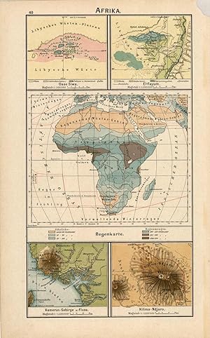
This map was produced for the 1902 Diercke, Schul-Atlas fur Hohere Lehranstalten, (Diercke Education Atlas for Higher Educational Institutions) This atlas was prepared and issued by C. Diercke and E.Gaebler for the Westermann publishing group in Braunschweig. With the help of fellow cartographer, Eduard Gaebler, Carl Dierckes ma…ps became a staple in the geography classrooms in Germany. From 1893 until his death, Diercke was editor of all the maps for Westermann Verlag. All text is in German with full color that has remained quite bold. A wonderful example of the fine German engraving work of the time. These beautiful, topographic maps show the physical attributes and contours of the land as well as identifies cities, countries, rivers, mountains, boundaries, and more. This is a single-sided map with five small sections showing of attributes or regions of Africa including: Oase Siwa (Siwa Oasis), El Fayum, Regenkarte (Rain Map), Kamerun-Gebirge (Cameroon Mountains), and Kilima-Ndjaro (Kilimandjaro). This map measures 6.75 inches by 12 inches.
Lingua: Tedesco
Editore: ohne Jahr (um 1820). 1820
- Rilegato
Da: Antiquariat Ralf Rindle, Cuxhaven, , GermaniaAntiquariat Ralf Rindle
Contatta il venditoreVenditore con 5 stelleCondizione: Usato - Come nuovo
EUR 53,00
EUR 69,95 spedizioneSpedito da Germania a U.S.A.Quantità: 1 disponibili
Condizione: Wie neu. Faltkarte, farbig. Karte in 3 Streifen geteilt, etwas fleckig, Stempel vorne, verso etwas stockfleckig. Mit offener Rechnung versenden wir gerne an Bibliotheken und Institutionen, Schulen, Universitäten etc. Sprache: Deutsch Gewicht in Gramm: 200 36,5 x 51,5 cm (ausgeklappt), 9 Teile auf Leinen aufgezogen.

Editore: George Westermann, Brausnschweig, 1902
Da: Bouquinerie du Varis, Russy, FR, SvizzeraBouquinerie du Varis
Contatta il venditoreVenditore con 5 stelleCondizione: Usato
EUR 62,20
EUR 27,95 spedizioneSpedito da Svizzera a U.S.A.Quantità: 1 disponibili
Verlegereinband. 365x220mm, En cas de problème de commande, veuillez nous contacter via notre page d'accueil / If there is a problem with the order, please contact us via our homepage.
Lingua: Tedesco
Editore: Archiv Verlag / Georg Westermann Verlag 1992
Da: KUNSTHAUS-STUTTGART, Stuttgart, GermaniaKUNSTHAUS-STUTTGART
Contatta il venditoreVenditore con 5 stelleCondizione: Usato
EUR 69,00
EUR 9,95 spedizioneSpedito da Germania a U.S.A.Quantità: 1 disponibili
Gebundene Ausgabe. (Lager 512) AAE3F10C98A1 Sprache: Deutsch Gewicht in Gramm: 500.

Lingua: Tedesco
Editore: Braunschweig, George Westermann
Da: Vintage13, Untersiemau, GermaniaVintage13
Contatta il venditoreVenditore con 5 stelleCondizione: Usato
EUR 33,70
EUR 46,00 spedizioneSpedito da Germania a U.S.A.Quantità: 1 disponibili
Zehnte Auflage. 40 S. beschriftet, fleckig, Bindung beschädigt 66 Sprache: Deutsch Gewicht in Gramm: 540.
Da: Art Source International Inc., Boulder, CO, U.S.A.Art Source International Inc.
Contatta il venditoreVenditore con 5 stelleCondizione: Usato
EUR 58,18
EUR 13,91 spedizioneSpedito in U.S.A.Quantità: 1 disponibili
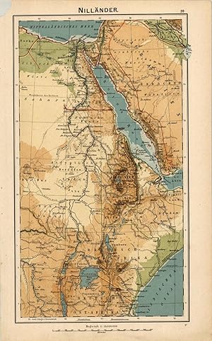
This map was produced for the 1902 Diercke, Schul-Atlas fur Hohere Lehranstalten, (Diercke Education Atlas for Higher Educational Institutions) This atlas was prepared and issued by C. Diercke and E.Gaebler for the Westermann publishing group in Braunschweig. With the help of fellow cartographer, Eduard Gaebler, Carl Dierckes ma…ps became a staple in the geography classrooms in Germany. From 1893 until his death, Diercke was editor of all the maps for Westermann Verlag. All text is in German with full color that has remained quite bold. A wonderful example of the fine German engraving work of the time. These beautiful, topographic maps show the physical attributes and contours of the land as well as identifies cities, countries, rivers, mountains, boundaries, and more. This single sided map shows the Nile River with a portion of Arabia. This map measures 6.75 inches by 12 inches.

Da: Art Source International Inc., Boulder, CO, U.S.A.Art Source International Inc.
Contatta il venditoreVenditore con 5 stelleCondizione: Usato
EUR 67,14
EUR 13,91 spedizioneSpedito in U.S.A.Quantità: 1 disponibili
This map was produced for the 1902 Diercke, Schul-Atlas fur Hohere Lehranstalten, (Diercke Education Atlas for Higher Educational Institutions) This atlas was prepared and issued by C. Diercke and E.Gaebler for the Westermann publishing group in Braunschweig. With the help of fellow cartographer, Eduard Gaebler, Carl Dierckes ma…ps became a staple in the geography classrooms in Germany. From 1893 until his death, Diercke was editor of all the maps for Westermann Verlag. All text is in German with full color that has remained quite bold. A wonderful example of the fine German engraving work of the time. These beautiful, topographic maps show the physical attributes and contours of the land as well as identifies cities, countries, rivers, mountains, boundaries, and more. They are double sided maps (shown side by side in image) which have corresponding information to the country on the opposite side. This map shows the continent of South America, divided into its states or countries on one side and has seven maps on the other side regarding: Meeresgebiete (Marine Areas), Vegetationsgebiete (Vegetation Areas), V'lkerkarte und Bev'lkerungsdichte (International and Population Density), Rio de Janeiro u. Umgegend (Rio de Janeiro and environs), and Caracas u. Umgegend. This map measures 15 inches by 12 inches.

Da: Art Source International Inc., Boulder, CO, U.S.A.Art Source International Inc.
Contatta il venditoreVenditore con 5 stelleCondizione: Usato
EUR 67,14
EUR 13,91 spedizioneSpedito in U.S.A.Quantità: 1 disponibili
This map was produced for the 1902 Diercke, Schul-Atlas fur Hohere Lehranstalten, (Diercke Education Atlas for Higher Educational Institutions) This atlas was prepared and issued by C. Diercke and E.Gaebler for the Westermann publishing group in Braunschweig. With the help of fellow cartographer, Eduard Gaebler, Carl Dierckes ma…ps became a staple in the geography classrooms in Germany. From 1893 until his death, Diercke was editor of all the maps for Westermann Verlag. All text is in German with full color that has remained quite bold. A wonderful example of the fine German engraving work of the time. These beautiful, topographic maps show the physical attributes and contours of the land as well as identifies cities, countries, rivers, mountains, boundaries, and more. They are double sided maps (shown side by side in image) which have corresponding information to the country on the opposite side. This map shows Europe, divided into its states or countries on one side and has four smaller maps on the other side regarding: Grosse Handelspl'tze, Industrie-und Bergwerksbezirke (Large Trading Centers, Industrial and Mining Districts), Direkte Entfernung der wichtigsten St'dte von Berlin und schnellste Verbindung mit denselben (Direct removal of the main cities of Berlin and fastest connection with the same), Religionskarte (Religion), Grossst'dte und Bev'lkerungsdichte (Major Cities and Population Density). This map measures 15 inches by 12 inches.

Da: Art Source International Inc., Boulder, CO, U.S.A.Art Source International Inc.
Contatta il venditoreVenditore con 5 stelleCondizione: Usato
EUR 67,14
EUR 13,91 spedizioneSpedito in U.S.A.Quantità: 1 disponibili
This map was produced for the 1902 Diercke, Schul-Atlas fur Hohere Lehranstalten, (Diercke Education Atlas for Higher Educational Institutions) This atlas was prepared and issued by C. Diercke and E.Gaebler for the Westermann publishing group in Braunschweig. With the help of fellow cartographer, Eduard Gaebler, Carl Dierckes ma…ps became a staple in the geography classrooms in Germany. From 1893 until his death, Diercke was editor of all the maps for Westermann Verlag. All text is in German with full color that has remained quite bold. A wonderful example of the fine German engraving work of the time. These beautiful, topographic maps show the physical attributes and contours of the land as well as identifies cities, countries, rivers, mountains, boundaries, and more. They are double sided maps (shown side by side in image) which have corresponding information to the country on the opposite side. This map shows the continent of Australia and Polynesian Islands on one side and has six maps on the other regarding: Meeresgebiete u. Temperatur (Marine Areas and Temperature), Vegetations u. Regenkarte (Vegetation and Rainfall), Samoa-Inslen (Samoa Islands), Volkerkarte und Bevolkerungsdichte (International and Population Density), Hawaii, Kwadjelinn-Gruppe (Kwadjelin/Marshall Islands). This map measures 15 inches by 12 inches.

Da: Art Source International Inc., Boulder, CO, U.S.A.Art Source International Inc.
Contatta il venditoreVenditore con 5 stelleCondizione: Usato
EUR 67,14
EUR 13,91 spedizioneSpedito in U.S.A.Quantità: 1 disponibili
This map was produced for the 1902 Diercke, Schul-Atlas fur Hohere Lehranstalten, (Diercke Education Atlas for Higher Educational Institutions) This atlas was prepared and issued by C. Diercke and E.Gaebler for the Westermann publishing group in Braunschweig. With the help of fellow cartographer, Eduard Gaebler, Carl Dierckes ma…ps became a staple in the geography classrooms in Germany. From 1893 until his death, Diercke was editor of all the maps for Westermann Verlag. All text is in German with full color that has remained quite bold. A wonderful example of the fine German engraving work of the time. These beautiful, topographic maps show the physical attributes and contours of the land as well as identifies cities, countries, rivers, mountains, boundaries, and more. They are double sided maps (shown side by side in image) which have corresponding information to the country on the opposite side. This map shows France on one side and has four smaller maps on the other side regarding: Rom und Umgegend (Rome and Environs), Rom u. das Albaner-Gebirge (Rome and the Albanian Mountains), Temperatur und wichtige Produkte (Temperature and Major Products), Golf von Neapel (Gulf of Naples), Toulon u. Umgegend (Toulon and environs), Lyon u. Umgegend (Lyon and Environs), Bev'lkerungsdichte (Population Density), Belfort u. Umgegend (Belfort and Environs), and Mt. Cenis. This map measures 15 inches by 12 inches.
Da: Art Source International Inc., Boulder, CO, U.S.A.Art Source International Inc.
Contatta il venditoreVenditore con 5 stelleCondizione: Usato
EUR 67,14
EUR 13,91 spedizioneSpedito in U.S.A.Quantità: 1 disponibili
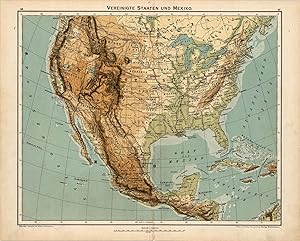
This map was produced for the 1902 Diercke, Schul-Atlas fur Hohere Lehranstalten, (Diercke Education Atlas for Higher Educational Institutions) This atlas was prepared and issued by C. Diercke and E.Gaebler for the Westermann publishing group in Braunschweig. With the help of fellow cartographer, Eduard Gaebler, Carl Dierckes ma…ps became a staple in the geography classrooms in Germany. From 1893 until his death, Diercke was editor of all the maps for Westermann Verlag. All text is in German with full color that has remained quite bold. A wonderful example of the fine German engraving work of the time. These beautiful, topographic maps show the physical attributes and contours of the land as well as identifies cities, countries, rivers, mountains, boundaries, and more. They are double sided maps (shown side by side in image) which have corresponding information to the country on the opposite side. This map shows the United States and Mexico on one side and six smaller maps with information on North America including: New York u. Umgegend (New York and environs), Baltimore u. Washington, Verbreitung der Neger u. Indianer (Dissemination of Negroes and Indians), Verbreitung der Deutschen (Dissemination of the German), Nationalpark (National Park - Yellowstone), and S. Francisco u. Umgegend (San Francisco and environs). There is also a single side topographic map of the West Indies which includes the islands of the Bahamas and Central America. This map measures 15 inches by 12 inches.

Da: Art Source International Inc., Boulder, CO, U.S.A.Art Source International Inc.
Contatta il venditoreVenditore con 5 stelleCondizione: Usato
EUR 67,14
EUR 13,91 spedizioneSpedito in U.S.A.Quantità: 1 disponibili
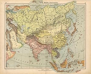
This map was produced for the 1902 Diercke, Schul-Atlas fur Hohere Lehranstalten, (Diercke Education Atlas for Higher Educational Institutions) This atlas was prepared and issued by C. Diercke and E.Gaebler for the Westermann publishing group in Braunschweig. With the help of fellow cartographer, Eduard Gaebler, Carl Dierckes ma…ps became a staple in the geography classrooms in Germany. From 1893 until his death, Diercke was editor of all the maps for Westermann Verlag. All text is in German with full color that has remained quite bold. A wonderful example of the fine German engraving work of the time. These beautiful, topographic maps show the physical attributes and contours of the land as well as identifies cities, countries, rivers, mountains, boundaries, and more. They are double sided maps (shown side by side in image) which have corresponding information to the country on the opposite side. This map shows Asia on one side and has four smaller maps on the other regarding: Temperaturkarte (Temperature), Meeresgebiete (Marine Areas), Regenkarte (Rainfall), Vegetationsgebiete (Vegetation). This map measures 15 inches by 12 inches.

Da: Art Source International Inc., Boulder, CO, U.S.A.Art Source International Inc.
Contatta il venditoreVenditore con 5 stelleCondizione: Usato
EUR 67,14
EUR 13,91 spedizioneSpedito in U.S.A.Quantità: 1 disponibili
This map was produced for the 1902 Diercke, Schul-Atlas fur Hohere Lehranstalten, (Diercke Education Atlas for Higher Educational Institutions) This atlas was prepared and issued by C. Diercke and E.Gaebler for the Westermann publishing group in Braunschweig. With the help of fellow cartographer, Eduard Gaebler, Carl Dierckes ma…ps became a staple in the geography classrooms in Germany. From 1893 until his death, Diercke was editor of all the maps for Westermann Verlag. All text is in German with full color that has remained quite bold. A wonderful example of the fine German engraving work of the time. These beautiful, topographic maps show the physical attributes and contours of the land as well as identifies cities, countries, rivers, mountains, boundaries, and more. They are double sided maps (shown side by side in image) which have corresponding information to the country on the opposite side. This map shows the Pyrenean Peninsula, or commonly called Iberia, on one side and has five maps on the other side regarding: Lissabon u. Tejo-M'ndung (Lisbon and Tagus estuary), Madrid u. Umgegend (Madrid and environs), Tempuratur und wichtige Produkte (Tempuratur and major products), Bai von Cadiz (Bay of Cadiz), and Strasse von Gibraltar (Strait of Gibraltar). There is also a single side of information on Frankreich (France) with five small maps of: Paris, Paris u. Umgegend (Paris and environs), Tempuratur und wichtige Produkte und Wasserstrassen (Tempuratur and major products and waterways), Cherbourg u. Umgegend (Cherbourg and environs), and Sedan u. Umgegend (Sedan and environs. This map measures 15 inches by 12 inches.

Da: Art Source International Inc., Boulder, CO, U.S.A.Art Source International Inc.
Contatta il venditoreVenditore con 5 stelleCondizione: Usato
EUR 67,14
EUR 13,91 spedizioneSpedito in U.S.A.Quantità: 1 disponibili
This map was produced for the 1902 Diercke, Schul-Atlas fur Hohere Lehranstalten, (Diercke Education Atlas for Higher Educational Institutions) This atlas was prepared and issued by C. Diercke and E.Gaebler for the Westermann publishing group in Braunschweig. With the help of fellow cartographer, Eduard Gaebler, Carl Dierckes ma…ps became a staple in the geography classrooms in Germany. From 1893 until his death, Diercke was editor of all the maps for Westermann Verlag. All text is in German with full color that has remained quite bold. A wonderful example of the fine German engraving work of the time. These beautiful, topographic maps show the physical attributes and contours of the land as well as identifies cities, countries, rivers, mountains, boundaries, and more. They are double sided maps (shown side by side in image) which have corresponding information to the country on the opposite side. This map shows North America, including Greeland, on one side and has four maps on the other regarding: Temperaturkarte (Temperature), Regenkarte (Rainfall), Meeresgebiete (Marine Areas), and Vegetationsgebiete (Vegetation Areas). This map measures 15 inches by 12 inches.
Da: Art Source International Inc., Boulder, CO, U.S.A.Art Source International Inc.
Contatta il venditoreVenditore con 5 stelleCondizione: Usato
EUR 67,14
EUR 13,91 spedizioneSpedito in U.S.A.Quantità: 1 disponibili
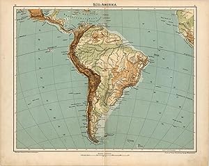
This map was produced for the 1902 Diercke, Schul-Atlas fur Hohere Lehranstalten, (Diercke Education Atlas for Higher Educational Institutions) This atlas was prepared and issued by C. Diercke and E.Gaebler for the Westermann publishing group in Braunschweig. With the help of fellow cartographer, Eduard Gaebler, Carl Dierckes ma…ps became a staple in the geography classrooms in Germany. From 1893 until his death, Diercke was editor of all the maps for Westermann Verlag. All text is in German with full color that has remained quite bold. A wonderful example of the fine German engraving work of the time. These beautiful, topographic maps show the physical attributes and contours of the land as well as identifies cities, countries, rivers, mountains, boundaries, and more. They are double sided maps (shown side by side in image) which have corresponding information to the country on the opposite side. This map shows the continent of South America on one side and has ten maps on the other side regarding: Maranon-M'ndung (Maranon-mouth), Magalhaens-Strasse (Magalhaens-road), Vegetations-u. Regenkarte (Vegetation and Rain map), Hochland von Quito (Highlands of Quito), Titicaca-See (Lake Titicaca), Isthmus von Tehuantepec (Isthmus of Tehuantepec), Isthmus von Nicaragua, Meeresgebiete u. Temperatur (Marine areas and Temperature), Isthmus von Panama, and Isthmus von Darien. This map measures 15 inches by 12 inches.
Da: Art Source International Inc., Boulder, CO, U.S.A.Art Source International Inc.
Contatta il venditoreVenditore con 5 stelleCondizione: Usato
EUR 67,14
EUR 13,91 spedizioneSpedito in U.S.A.Quantità: 1 disponibili
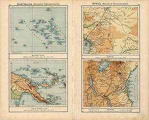
This map was produced for the 1902 Diercke, Schul-Atlas fur Hohere Lehranstalten, (Diercke Education Atlas for Higher Educational Institutions) This atlas was prepared and issued by C. Diercke and E.Gaebler for the Westermann publishing group in Braunschweig. With the help of fellow cartographer, Eduard Gaebler, Carl Dierckes ma…ps became a staple in the geography classrooms in Germany. From 1893 until his death, Diercke was editor of all the maps for Westermann Verlag. All text is in German with full color that has remained quite bold. A wonderful example of the fine German engraving work of the time. These beautiful, topographic maps show the physical attributes and contours of the land as well as identifies cities, countries, rivers, mountains, boundaries, and more. They are double sided maps (shown side by side in image) which have corresponding information to the country on the opposite side. This map shows the Pacific Ocean with Australia and North America, with portions of Asia and Africa on one side and has four maps on the other of areas in Australia and Africa showing: Australien, Deutsche Schutzgebiete (Australia, German Conservation Areas) - Marshall Inslen (Marshall Islands) and Kaiser Wilhelm-Land. Afrika, Deutsche Schutzgebiete (Africa, German Conservation Areas) - Kamerun (Cameroons), Ost-Afrika (East Africa). This map measures 15 inches by 12 inches.
Da: Art Source International Inc., Boulder, CO, U.S.A.Art Source International Inc.
Contatta il venditoreVenditore con 5 stelleCondizione: Usato
EUR 67,14
EUR 13,91 spedizioneSpedito in U.S.A.Quantità: 1 disponibili
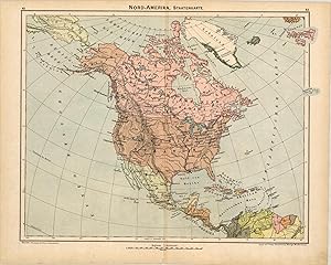
This map was produced for the 1902 Diercke, Schul-Atlas fur Hohere Lehranstalten, (Diercke Education Atlas for Higher Educational Institutions) This atlas was prepared and issued by C. Diercke and E.Gaebler for the Westermann publishing group in Braunschweig. With the help of fellow cartographer, Eduard Gaebler, Carl Dierckes ma…ps became a staple in the geography classrooms in Germany. From 1893 until his death, Diercke was editor of all the maps for Westermann Verlag. All text is in German with full color that has remained quite bold. A wonderful example of the fine German engraving work of the time. These beautiful, topographic maps show the physical attributes and contours of the land as well as identifies cities, countries, rivers, mountains, boundaries, and more. They are double sided maps (shown side by side in image) which have corresponding information to the country on the opposite side. This map shows North America, including Greeland, divided into its states on one side and has eight smaller maps on the other regarding: Gr'nlands Westk'ste (Greenland's west coast), Mississippi -M'ndungen (Mississippi estuaries), Bodenbenutzung (soil use), Industriekarte (Industry Map), Kap Hatteras (Cape Hatteras), Canon des Colorado, V'lkerkarte (International Map), and Bev'lkerungsdichte und wichtige Verkehrswege (Population density and major transportation routes). This map measures 15 inches by 12 inches.
Da: Art Source International Inc., Boulder, CO, U.S.A.Art Source International Inc.
Contatta il venditoreVenditore con 5 stelleCondizione: Usato
EUR 67,14
EUR 13,91 spedizioneSpedito in U.S.A.Quantità: 1 disponibili
This map was produced for the 1902 Diercke, Schul-Atlas fur Hohere Lehranstalten, (Diercke Education Atlas for Higher Educational Institutions) This atlas was prepared and issued by C. Diercke and E.Gaebler for the Westermann publishing group in Braunschweig. With the help of fellow cartographer, Eduard Gaebler, Carl Dierckes ma…ps became a staple in the geography classrooms in Germany. From 1893 until his death, Diercke was editor of all the maps for Westermann Verlag. All text is in German with full color that has remained quite bold. A wonderful example of the fine German engraving work of the time. These beautiful, topographic maps show the physical attributes and contours of the land as well as identifies cities, countries, rivers, mountains, boundaries, and more. They are double sided maps (shown side by side in image) which have corresponding information to the country on the opposite side. This map shows Asia, divided into it's states or countries on one side and has ten smaller maps on the other side of several areas within Asia including: Das heutige Jerusalem (Today's Jerusalem), Jerusalem u. Umgegend (Jerusalem and environs), Religionskarte (Religion), Gengend zwischen Nazareth u. Tiberias, Sinai (Sinai Mountains), Eriwan (Yerevan), Pamir (Pamir Mountains), Verbreitung der wichtigsten Pflanzen (dissemination of important plant), Gaurisankar, and Karakorum. This map measures 15 inches by 12 inches.

Da: Art Source International Inc., Boulder, CO, U.S.A.Art Source International Inc.
Contatta il venditoreVenditore con 5 stelleCondizione: Usato
EUR 67,14
EUR 13,91 spedizioneSpedito in U.S.A.Quantità: 1 disponibili
This map was produced for the 1902 Diercke, Schul-Atlas fur Hohere Lehranstalten, (Diercke Education Atlas for Higher Educational Institutions) This atlas was prepared and issued by C. Diercke and E.Gaebler for the Westermann publishing group in Braunschweig. With the help of fellow cartographer, Eduard Gaebler, Carl Dierckes ma…ps became a staple in the geography classrooms in Germany. From 1893 until his death, Diercke was editor of all the maps for Westermann Verlag. All text is in German with full color that has remained quite bold. A wonderful example of the fine German engraving work of the time. These beautiful, topographic maps show the physical attributes and contours of the land as well as identifies cities, countries, rivers, mountains, boundaries, and more. They are double sided maps (shown side by side in image) which have corresponding information to the country on the opposite side. This map shows western Asia on one side and has five smaller maps on the other side regarding: Chiwa (Khiva), Gangesdelta (Ganges Delta), V'lkerkarte (International Map), Strasse Bab el-Mandeb (Street Bab el-Mandeb), and Strasse von Malaka (Strait of Malacca). There is a single side topographic map of Palestine that shows Galilee down to the Dead Sea. This map measures 15 inches by 12 inches.

Da: Art Source International Inc., Boulder, CO, U.S.A.Art Source International Inc.
Contatta il venditoreVenditore con 5 stelleCondizione: Usato
EUR 67,14
EUR 13,91 spedizioneSpedito in U.S.A.Quantità: 1 disponibili
This map was produced for the 1902 Diercke, Schul-Atlas fur Hohere Lehranstalten, (Diercke Education Atlas for Higher Educational Institutions) This atlas was prepared and issued by C. Diercke and E.Gaebler for the Westermann publishing group in Braunschweig. With the help of fellow cartographer, Eduard Gaebler, Carl Dierckes ma…ps became a staple in the geography classrooms in Germany. From 1893 until his death, Diercke was editor of all the maps for Westermann Verlag. All text is in German with full color that has remained quite bold. A wonderful example of the fine German engraving work of the time. These beautiful, topographic maps show the physical attributes and contours of the land as well as identifies cities, countries, rivers, mountains, boundaries, and more. They are double sided maps (shown side by side in image) which have corresponding information to the country on the opposite side. This map shows Europe on one side and has four maps on the other regarding: Geologische 'bersicht (Geological Overview), Temperaturkarte (Temperature), V'lkerkarte (International Map), Regenkarte (Rainfall). This map measures 15 inches by 12 inches.


