Importo totale (1 articolo articoli):
Destinazione ordine:

gazzettiere americano (5 risultati)
Vai alla pagina principale dei risultati di ricerca
Tipo di articolo
- Tutti gli articoli
- Libri (3)
- Riviste e Giornali
- Fumetti
- Spartiti
- Arte, Stampe e Poster (1)
- Fotografie
- Mappe (1)
-
Manoscritti e
Collezionismo cartaceo
Condizioni
- Tutte
- Nuovi
- Antichi o usati
Legatura
- Tutte
- Rilegato (2)
- Brossura
Ulteriori caratteristiche
- Prima edizione
- Copia autografata
- Sovraccoperta
- Con foto (3)
- No print on demand
Paese del venditore
Valutazione venditore
-
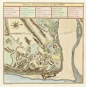
Piano della Citta di Quebec.
Data di pubblicazione: 1763
Da: Altea Antique Maps, London, Regno Unito
Membro dell'associazione: ABA ILAB PBFA
Valutazione venditore:

Mappa
No Binding. Condizione: As New. Livorno: Marco Coltellini, 1763. Coloured. 255 x 250mm. A detailed plan of the city of Quebec, orientated with north to the right, published at the close of the Seven Years' War, in which Britain captured the city from the French. A 24-point key lists the important buildings, The map was engraved by Veremondo Rossi for the 'Gazzettiere Americano', an expanded Italian edition of the 'American Gazetteer' published in London in 1762.
-
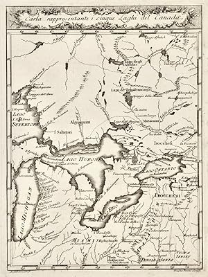
Carta rappresentante i cinque Laghi del Canada.
Editore: Livorno,, 1763
Da: libreria antiquaria perini Sas di Perini, Verona, VR, Italia
Membro dell'associazione: ALAI ILAB
Valutazione venditore:
Arte / Stampa / Poster
Carta rappresentante i cinque Laghi del Canada. Incisione in rame, 255x195. Eseguita da Andrea Scacciati. Bell'esemplare con un leggerissimo alone all'angolo sup. destro. Nr.cat: PB250007.
-

Carta Rappresentante il Porto di Boston.
Editore: From Il Gazzettiere Americano by M. Coltellini. Livorno. 1763., 1763
Da: Bickerstaff's Books, Maps &c., Scarborough, ME, U.S.A.
Membro dell'associazione: ABAA ESA ILAB
Valutazione venditore:
An attractive and uncommon Italian map of the Boston harbor area from 1763. In addition to identifying many of the coastal towns surrounding Boston, the map names many of the harbor islands. Dozens of soundings are provided and the main ship channel is shown as well. The scrollwork title and depiction of landscape elements on the land areas add considerable visual appeal to this map. Phillips, A List of Maps of America: p. 147. Not in Boston Engineering Department, List of Maps of Boston Published Subsequent to 1600. Traces of removed mounting tape on reverse. Very good. 8 1/4 x 7.".
-
(vol. I e II, su tre), contenente un distinto ragguaglio di tutte le pňarti del Nuovo Mondo, della loro situazione, clima, terreno, prodotti, merci, manifatture e commercio
Da: Libreria Antiquaria Pregliasco, Torino, Italia
Membro dell'associazione: ALAI ILAB
Valutazione venditore:
Condizione: molto buono. 2 vol. in-4 (primo e secondo, manca il terzo), pp.XXIII, 216, 256. 1 f. in fine dei 2 vol. per l'Indice dei rami. Al vol. primo finissimo antiporta raffigurante l'incontro di Colombo con gli Indigeni. Vignette, finalini e 54 incisioni f.testo (su 78 dei tre volumi: 31 nel primo, 23 nel II) molte ripiegate (carte geogr., vedute, costumi d riti degli indigeni, fauna e flora). Pubblicazione di fondamentale importanza per la conoscenza di storia naturale, economia e sociologia dell'America Settentrionale e Meridionale; ogni localitŕ viene accuratamente descritta in ordine alfabetico. Le incisioni, per lo piů opera di V.Vanni, V.Rossi, A.Scacciati e G.M. Terreni, sono anche molto decorative. Unica edizione, che traduce un volume anonimo pubblicato a Londra l'anno precedente, privo di tavole. Sabin 26814. Leclerc 233. J.Carter Brown, Italians and creation of America 81: «The printer has elevated the cramped, unattractive English original into a handsome book, and the visual effect of the Italian edition is strikingly superior. there is much more information about the English colonies in America than is found in most geographical books written by continental authors up to this time» . Book.
-
Il Gazzettiere Americano, contenente un distinto Ragguaglio di Tutte le Parti del Nuovo Mondo.
Editore: Livorno, Marco Coltellini, Livorno, 1763
Da: MEDA RIQUIER RARE BOOKS LTD, London, Regno Unito
Membro dell'associazione: ABA ILAB
Valutazione venditore:

Condizione: Buono (Good). Book.