
Importo totale (1 articolo articoli):
Destinazione ordine:

geographical section general staff office (13 risultati)
Vai alla pagina principale dei risultati di ricerca
Tipo di articolo
- Tutti gli articoli
- Libri (10)
- Riviste e Giornali
- Fumetti
- Spartiti
- Arte, Stampe e Poster
- Fotografie
- Mappe (3)
-
Manoscritti e
Collezionismo cartaceo
Condizioni
Legatura
Ulteriori caratteristiche
- Prima edizione (1)
- Copia autografata
- Sovraccoperta
- Con foto
- No print on demand (7)
Spedizione gratuita
Paese del venditore
Valutazione venditore
-
![Immagine del venditore per Handbook to map of Fu-Chien (G.S.G.S. no. 2165) giving Chinese characters and pronunciation for the names shewn on the map . with list of some Chinese words used in geographical nomenclature. Prepared in the Geographical Section, General staff. War office, 1908. (1908) [Leatherbound] venduto da S N Books World](https://pictures.abebooks.com/inventory/md/md30877385319.jpg)
Handbook to map of Fu-Chien (G.S.G.S. no. 2165) giving Chinese characters and pronunciation for the names shewn on the map . with list of some Chinese words used in geographical nomenclature. Prepared in the Geographical Section, General staff. War office, 1908. (1908) [Leatherbound]
Data di pubblicazione: 2022
Libro Print on Demand
LeatherBound. Condizione: NEW. Leatherbound edition. Condition: New. Leather Binding on Spine and Corners with Golden leaf printing on spine. Bound in genuine leather with Satin ribbon page markers and Spine with raised gilt bands. A perfect gift for your loved ones. Reprinted from 1908 edition. NO changes have been made to the original text. This is NOT a retyped or an ocr'd reprint. Illustrations, Index, if any, are included in black and white. Each page is checked manually before printing. As this print on demand book is reprinted from a very old book, there could be some missing or flawed pages, but we always try to make the book as complete as possible. Fold-outs, if any, are not part of the book. If the original book was published in multiple volumes then this reprint is of only one volume, not the whole set. IF YOU WISH TO ORDER PARTICULAR VOLUME OR ALL THE VOLUMES YOU CAN CONTACT US. Resized as per current standards. Sewing binding for longer life, where the book block is actually sewn (smythe sewn/section sewn) with thread before binding which results in a more durable type of binding. Pages: 208 Language: English Pages: 208.
-
![Immagine del venditore per Handbook to Map of Fu-Chien (G.S.G.S. No. 2165) Giving Chinese Characters and Pronunciation for the Names Shewn on the Map . with List of Some Chinese Words Used in Geographical Nomenclature 1908 [LeatherBound] venduto da True World of Books](https://pictures.abebooks.com/inventory/md/md31617122466.jpg)
Handbook to Map of Fu-Chien (G.S.G.S. No. 2165) Giving Chinese Characters and Pronunciation for the Names Shewn on the Map . with List of Some Chinese Words Used in Geographical Nomenclature 1908 [LeatherBound]
Data di pubblicazione: 2023
Libro Print on Demand
LeatherBound. Condizione: New. LeatherBound edition. Condition: New. Reprinted from edition. Leather Binding on Spine and Corners with Golden leaf printing on spine. Bound in genuine leather with Satin ribbon page markers and Spine with raised gilt bands. A perfect gift for your loved ones. NO changes have been made to the original text. This is NOT a retyped or an ocr'd reprint. Illustrations, Index, if any, are included in black and white. Each page is checked manually before printing. As this print on demand book is reprinted from a very old book, there could be some missing or flawed pages, but we always try to make the book as complete as possible. Fold-outs, if any, are not part of the book. If the original book was published in multiple volumes then this reprint is of only one volume, not the whole set. Sewing binding for longer life, where the book block is actually sewn (smythe sewn/section sewn) with thread before binding which results in a more durable type of binding. Pages: 207.
-
![Immagine del venditore per Handbook to map of Fu-chien (G.S.G.S. no. 2165). (1908) [Leatherbound] venduto da S N Books World](https://pictures.abebooks.com/inventory/md/md31376602235.jpg)
Handbook to map of Fu-chien (G.S.G.S. no. 2165). (1908) [Leatherbound]
Data di pubblicazione: 2022
Libro Print on Demand
LeatherBound. Condizione: New. Leatherbound edition. Condition: New. Leather Binding on Spine and Corners with Golden leaf printing on spine. Bound in genuine leather with Satin ribbon page markers and Spine with raised gilt bands. A perfect gift for your loved ones. Reprinted from 1908 edition. NO changes have been made to the original text. This is NOT a retyped or an ocr'd reprint. Illustrations, Index, if any, are included in black and white. Each page is checked manually before printing. As this print on demand book is reprinted from a very old book, there could be some missing or flawed pages, but we always try to make the book as complete as possible. Fold-outs, if any, are not part of the book. If the original book was published in multiple volumes then this reprint is of only one volume, not the whole set. IF YOU WISH TO ORDER PARTICULAR VOLUME OR ALL THE VOLUMES YOU CAN CONTACT US. Resized as per current standards. Sewing binding for longer life, where the book block is actually sewn (smythe sewn/section sewn) with thread before binding which results in a more durable type of binding. Pages: 208 Language: English Pages: 208.
-
![Immagine del venditore per Handbook to map of Fu-Chien (G.S.G.S. no. 2165) giving Chinese characters and pronunciation for the names shewn on the map . with list of some Chinese words used in geographical nomenclature [LeatherBound] venduto da True World of Books](https://pictures.abebooks.com/inventory/md/md31532917143.jpg)
Handbook to map of Fu-Chien (G.S.G.S. no. 2165) giving Chinese characters and pronunciation for the names shewn on the map . with list of some Chinese words used in geographical nomenclature [LeatherBound]
Data di pubblicazione: 2023
Libro Print on Demand
LeatherBound. Condizione: New. LeatherBound edition. Condition: New. Reprinted from 1908 edition. Leather Binding on Spine and Corners with Golden leaf printing on spine. Bound in genuine leather with Satin ribbon page markers and Spine with raised gilt bands. A perfect gift for your loved ones. NO changes have been made to the original text. This is NOT a retyped or an ocr'd reprint. Illustrations, Index, if any, are included in black and white. Each page is checked manually before printing. As this print on demand book is reprinted from a very old book, there could be some missing or flawed pages, but we always try to make the book as complete as possible. Fold-outs, if any, are not part of the book. If the original book was published in multiple volumes then this reprint is of only one volume, not the whole set. Sewing binding for longer life, where the book block is actually sewn (smythe sewn/section sewn) with thread before binding which results in a more durable type of binding. Pages: 212 Language: English.
-
![Immagine del venditore per Short glossary of Turkish. (1943) [Leatherbound] venduto da S N Books World](https://pictures.abebooks.com/inventory/md/md30877578828.jpg)
LeatherBound. Condizione: NEW. Leather Binding on Spine and Corners with Golden leaf printing on spine. Bound in genuine leather with Satin ribbon page markers and Spine with raised gilt bands. A perfect gift for your loved ones. Reprinted from 1943 edition. NO changes have been made to the original text. This is NOT a retyped or an ocr'd reprint. Illustrations, Index, if any, are included in black and white. Each page is checked manually before printing. As this print on demand book is reprinted from a very old book, there could be some missing or flawed pages, but we always try to make the book as complete as possible. Fold-outs, if any, are not part of the book. If the original book was published in multiple volumes then this reprint is of only one volume, not the whole set and contains approximately 24 pages. IF YOU WISH TO ORDER PARTICULAR VOLUME OR ALL THE VOLUMES YOU CAN CONTACT US. Resized as per current standards. Sewing binding for longer life, where the book block is actually sewn (smythe sewn/section sewn) with thread before binding which results in a more durable type of binding. Language: English.
-

England and Wales. Ordnance survey maps: Ribblesdale / Kirkby Lonsdale & Hawees. Sheet 20 u. 25. Second War Revision 1940. 2 Karten
Da: Celler Versandantiquariat, Eicklingen, Germania
Membro dell'associazione: GIAQ
Valutazione venditore:

Libro
Sifton, Praed & Co., London, 1940/1942. 2 auf Leinen gezogene, mehrfach gefaltete Karten, Scale: 1 Inch to a Mile, 75,5 cm x 53,5 cm, (leicht fleckig / private Anmerkung auf Titel)---- englisch - 192 Gramm.
-
![Immagine del venditore per Short glossary of French topographical terms and abbreviations. (1944) [Leatherbound] venduto da S N Books World](https://pictures.abebooks.com/inventory/md/md30877592705.jpg)
Short glossary of French topographical terms and abbreviations. (1944) [Leatherbound]
Data di pubblicazione: 2022
Libro Print on Demand
LeatherBound. Condizione: NEW. Leather Binding on Spine and Corners with Golden leaf printing on spine. Bound in genuine leather with Satin ribbon page markers and Spine with raised gilt bands. A perfect gift for your loved ones. Reprinted from 1944 edition. NO changes have been made to the original text. This is NOT a retyped or an ocr'd reprint. Illustrations, Index, if any, are included in black and white. Each page is checked manually before printing. As this print on demand book is reprinted from a very old book, there could be some missing or flawed pages, but we always try to make the book as complete as possible. Fold-outs, if any, are not part of the book. If the original book was published in multiple volumes then this reprint is of only one volume, not the whole set and contains approximately 34 pages. IF YOU WISH TO ORDER PARTICULAR VOLUME OR ALL THE VOLUMES YOU CAN CONTACT US. Resized as per current standards. Sewing binding for longer life, where the book block is actually sewn (smythe sewn/section sewn) with thread before binding which results in a more durable type of binding. Language: English.
-
![Immagine del venditore per UNE GRANDE CARTE ENTOILČE du SČNČGAL [ AFRIQUE ] 64 x 85 cm , ETABLIE en 1940 venduto da LA FRANCE GALANTE](https://pictures.abebooks.com/inventory/md/md22061481876.jpg)
UNE GRANDE CARTE ENTOILČE du SČNČGAL [ AFRIQUE ] 64 x 85 cm , ETABLIE en 1940
Da: LA FRANCE GALANTE, Saint MARTIN sur LAVEZON, Francia
Valutazione venditore:
Libro
Couverture souple. Condizione: Trčs bon. GEOGRAPHICAL SECTION , GENERAL STAFF : WAR OFFICE . 1940 . N° 2871 .UNE GRANDE CARTE ENTOILČE du SČNČGAL [ AFRIQUE ] 64 x 85 cm , ETABLIE en 1940 , d'aprés une carte française de 1936 .
-
Romania 1:000,000 O.S.Maps 1944 (55 Original full colour wartime dated Maps)
Editore: War Office, 1944
Da: WORLD WAR BOOKS, TUNBRIDGE WELLS, Regno Unito
Membro dell'associazione: PBFA
Valutazione venditore:
Libro Prima edizione
Soft cover. Condizione: Very Good. No Jacket. 1st Edition. Interesting set of 55 original Ordnance Survey of Romania, full colour and produced by the War Office from the official Romanian 1:100,000 sheets mainly dated 1939.Most sheets c. 80 cms x 60 cms and dated either 1944 or 1943. Earliest numbered Sheet 2060 finishing at 6065. Not a complete run as far as we can tell but 55 all printed "First Edition" Modest stamp to margin of Kings College London. The 55, all in very good condition. Likely to be most sensibly shipped in the UK due to weight and size.
-
Hardcover. Condizione: Fine. 3rd Edition. Colour map 76x65cm mounted on linen and folded into a gilt-titled burgundy cloth case 18x28cm. Fine. This is the 3rd edition 1945, reproduced by the Ordnance Survey from MDR I/12054 1944, with air information from RAF Middle East HQ dated Dec 1944. About centred on the Strait of Hormuz, this covers the Arabian side of the Arabian / Persian Gulf and Gulf of Oman from Qantar to Al Qasbiyat (naming Abu Dhabi, Dubai, Sharjah, Ajman, Umm al Quwain, Ras al Khaimah, Fujairah and Independent Oman) and inland to Buraimi and Hafit. On the Iranian side it covers the Shibkuh Coast to Ras Tank, and inland to the north of Lar, with steamer service routes indicated from Bandar Abbas to Bushire and Muscat. Extensive geographical information is supported by Arabic-English and Iranian-English glossaries.
-
TANZANIA / RWANDA / BURUNDI - WORLD WAR I IN EAST AFRICA: German East Africa. Scale 1:2,000,000 or 1.014 Inches = 32 Miles.
Editore: Southampton, England: Ordnance Survey Office, ., 1914
Da: Antiquariat Dasa Pahor GbR, München, Germania
Membro dell'associazione: ILAB VDA
Valutazione venditore:

Libro
Photolithographic print, with contemporary manuscript additions in coloured crayon and red and black pen, mounted upon original linen, curiously with the panels of an Italian map of Dalmatia mounted to verso (Good, some wear and toning along old folds, one panel toned, a few small stains, a tiny piece of blank margin excised in lower left corner), 80.5 x 75.5 cm (31.5 x 29.5 inches). A seemingly unrecorded special 'emergency' issue of Max Moisel's groundbreaking map of Deutsch-Ostafrika (today's mainland Tanzania, Rwanda and Burundi), issued in haste by British War Office immediately following the outbreak of World War I, whereupon East Africa became a surprisingly intense conflict theatre; the present example bearing evidence of field use, featuring contemporary manuscript additions. - Upon the outbreak of World War I, Britain was determined to invade the German colony of Deutsch-Ostafrika (comprising today's mainland Tanzania, Rwanda and Burundi). They expected to easily roll over the small and poorly armed Schutztruppe, the German colonial defense force, attaining complete victory in only a matter of weeks. However, to almost everyone's surprise, the regional German commander, Colonel Emil von Lettow-Vorbeck, later known as the 'Lion of Africa', galvanized his rag-tag army into a disciplined and wiley guerilla movement that drew the dramatically largee British imperial forces into an endless series of deadly ambushes and wild goose chases, depleting their numbers and dampening their morale. While the British eventually conquered Deutsch-Ostafrika, at the end of the war Lettow-Vorbeck remained on the offensive, unvanquished, and was only compelled to surrender upon the general capitulation of Germany in November 1918. In the summer of 1914, at the start of hostilities on East Africa, the British high command, despite their optimism and enthusiasm, had a problem. They knew that invading Deutsch-Ostafrika would involve irregular combat in rugged, and often exotic terrain, little known to virtually any of their troops. In this context, access to accurate, scientific cartography would be not merely important, but absolutely critical. Fortunately, the Germans had long published what was the only existing accurate general map of the colony, predicated upon systematic surveys sponsored in the late 1890s by their Colonial Ministry, being Max Moisel's Deutsch-Ostafrika. Neubearbeitung von Max Moisel, issued in several updated editions from 1900 until the eve of the war. However, the British War Office and associated entities possessed only a few examples of the Moisel map, far less than what was needed for distribution to high-level planners in London, let alone field commanders operating in Africa. The present map represents the provisional solution to this problem. In the earliest days of the war, the Geographical Section of the General Staff (GSGS) of the War Office, the entity responsible for the British Army's cartographic programmes, acquired a late edition of Moisel's Deutsch-Ostafrika, and had it hastily and crudely photographically printed at the Ordnance Survey Office in Southampton, which was responsible for producing many of the the GSGS's maps. The result is the present work, which was almost certainly the very first general map of German East Africa produced by the British military during World War I and would have been made in only a handful of examples to be rushed out to very senior strategists and field commanders. As a comparison between the present work and the Moisel map demonstrates, the Southampton edition faithfully duplicates all of the details of the antecedent, bearing the same scale of 1:2,000,000; however, here it has been retitled into the English language, while the original map's German language legend and the regional inset map had been covered up (leaving a large blank space in the lower-left quadrant), while the scope has been truncated to leave out what could have been considered to be the Moisel map's superfluous coverage of the areas to the north and south of Deutsch-Ostafrika (i.e. leaving out parts of Mozambique and Nyasaland, in the south, and the farther reaches of Lake Victoria, in the north). SEE OUR WEB PAGE FOR A LONGER DESCRIPTION . References: N/A Map seemingly unrecorded. Cf. [re: 1915 Pretoria ed.]: Bodleian Library (Oxford University): 754.11 t.1 (36); [re. 1916 War Office ed.]: British Library: Cartographic Items Maps 66430.(50.) / OCLC: 557512391 / 497585629.
-

Map of Nanking Compiled, drawn and printed at the War Office, 1927.
Editore: War Office, Geographical Section, General Staff, 1927
Da: Daniel Crouch Rare Books Ltd, London, Regno Unito
Membro dell'associazione: ABA ILAB PBFA
Valutazione venditore:

Mappa
General Staff map of Nanking Coloured lithograph map dissected into 32 (4 by 8) sections mounted on linen. Scale 1:250,000 Nanking in 1927 was a treaty port located on the southern shores of the Yangtze River. Because the foreign interests in China were largely American and European, squadrons of foreign naval vessels were stationed along the Yangtze to protect their citizens doing business at the treaty ports. The British Royal Navy operated the China Station under Rear Admiral Sir Reginald Tyrwhitt and the United States Navy the Yangtze Patrol; both lasted for around 80 years until World War II.
-
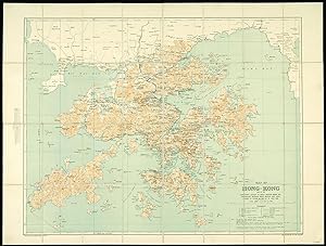
Map of Hong Kong and the Territory leased to Great Britain under the Convention between Great Britain and China, signed at Peking on the 9th of June 1898.
Editore: Hong Kong,, 1922
Da: Daniel Crouch Rare Books Ltd, London, Regno Unito
Membro dell'associazione: ABA ILAB PBFA
Valutazione venditore:
Mappa
Hong Kong - the ailing Qing dynasty leased to Great Britain, 1898 Colour lithographed map, dissected and mounted on linen, folding map. An early, attractive, and detailed map of Hong Kong and the New Territories first published in 1905 and re-issued with additions in 1922. From another example of this chart we have handled, it appears that the coastline from Sai Kung to Mirs Point onwards was taken from Admiralty charts; that of Deep Bay, from the mouth of the Sham Chun River to South-West Point, from a survey by the P.W.D.; thence northward and westward from Admiralty charts; that of Lan Tao and adjacent islands from a 1-inch map compiled by Tate; and the New Territories from a map compiled by W. J. Newland in 1903-04, with additions and revisions by P.W.D. in 1913 and 1922. As listed in the Reference table, the map shows Important Villages & Market Places; Villages; Churches & Mission Stations; Pagodas & Temples; Pass; Heights in Feet above Sea Level; Bridges; Limit of Navigation for Large Junks; Cart Roads; Pack Roads & Paths; Telegraphs; Tramways; Boundary of British Territory; and Railways. "The local spelling of place-names has been followed". This map has been compiled from Existing Intelligence Division maps of Hong Kong; Admiralty Charts; Map of New Territory Kowloon, compiled by Mr. Tate for Colonial Government Survey 1899 1900; Survey of Kowloon and part of New Territory (8 In. 1 Mile) carried out in 1902-1903. The boundary along the Shores of Mirs Bay and Deep Bay is the High Water Mark. It has not yet been surveyed and is only shown provisionally. Geographical Section General Staff No. 1393. Additions, Mar. 1922, War Office, Aug. 1905. Scale 1:84,480 or ľ Inch to 1 Mile.
![Immagine del venditore per [Map] Asia 1/1M, GSGS 2555, NG-40, Bandar Abbas venduto da Dendera](https://pictures.abebooks.com/inventory/md/md31762787128.jpg)
