
Importo totale (1 articolo articoli):
Destinazione ordine:

hatch engraver (2 risultati)
Vai alla pagina principale dei risultati di ricerca
Filtri di ricerca
Tipo di articolo
- Tutti i tipi di prodotto
- Libri (Nessun altro risultato corrispondente a questo perfezionamento)
- Riviste e Giornali (Nessun altro risultato corrispondente a questo perfezionamento)
- Fumetti (Nessun altro risultato corrispondente a questo perfezionamento)
- Spartiti (Nessun altro risultato corrispondente a questo perfezionamento)
- Arte, Stampe e Poster (Nessun altro risultato corrispondente a questo perfezionamento)
- Fotografie (Nessun altro risultato corrispondente a questo perfezionamento)
- Mappe (2)
- Manoscritti e Collezionismo cartaceo (Nessun altro risultato corrispondente a questo perfezionamento)
Condizioni Maggiori informazioni
- Nuovo (Nessun altro risultato corrispondente a questo perfezionamento)
- Come nuovo, Ottimo o Quasi ottimo (Nessun altro risultato corrispondente a questo perfezionamento)
- Molto buono o Buono (2)
- Discreto o Mediocre (Nessun altro risultato corrispondente a questo perfezionamento)
- Come descritto (Nessun altro risultato corrispondente a questo perfezionamento)
Legatura
- Tutte
- Rilegato (Nessun altro risultato corrispondente a questo perfezionamento)
- Brossura (Nessun altro risultato corrispondente a questo perfezionamento)
Ulteriori caratteristiche
- Prima ed. (Nessun altro risultato corrispondente a questo perfezionamento)
- Copia autograf. (Nessun altro risultato corrispondente a questo perfezionamento)
- Sovracoperta (Nessun altro risultato corrispondente a questo perfezionamento)
- Con foto (2)
- Non Print on Demand (2)
Lingua (1)
Prezzo
- Qualsiasi prezzo
- Inferiore a EUR 20 (Nessun altro risultato corrispondente a questo perfezionamento)
- EUR 20 a EUR 45
- Superiore a EUR 45 (Nessun altro risultato corrispondente a questo perfezionamento)
Spedizione gratuita
- Spedizione gratuita in U.S.A. (Nessun altro risultato corrispondente a questo perfezionamento)
Paese del venditore
Valutazione venditore
-
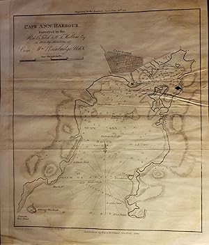
Original Map - "Cape Ann Harbour. Surveyed by the Rev. C. Fetch and W. T. Mallone Esq. in 1819 by Direction of Come. Wm. Bainbridge, USN."
Editore: E. and G. W. Blunt, New York, 1841
Da: Barry Cassidy Rare Books, Sacramento, CA, U.S.A.
Valutazione del venditore 5 su 5 stelle

Mappa
No Binding. Condizione: Collectible-Very Good. Original publisher's black and white engraved nautical chart showing Cape Ann Harbor in Massachusetts. Chart with margins measures 8 1/2" x 10 1/4"; actual chart area measures 7 1/2" x 8 3/4." Chart is very clean and intact. There are a few horizontal fold lines. One of the fold lines has one very small chip. Faint dampstaining on map. Scale of distance in statute miles in upper-left corner below title. "Engraved for the American Coast Pilot, 14th Ed." printed above the chart. "Drawn by E. Blunt.; Printed by W. Hooker.; New York, Published by E. & G.W. Blunt, 1841.; Plan Engd. by Hatch." printed beneath the chart. Chart includes numbers showing water depths, a compass rose with magnetic variation, and other navigational aids. The chart also shows geographical features such as capes, coves, and points. Gloucester shown at top. Edmund Blunt (1770-1862) was a publisher of nautical charts and books and printed the first edition of the American Coast Pilot in 1796. Around 1827, Blunt retired and his sons took over the company and continued his work as a publisher of high-quality sea charts. The Blunts were also known for their collaboration with the U.S. Coast Survey which allowed their charts to be up-to-date.
-
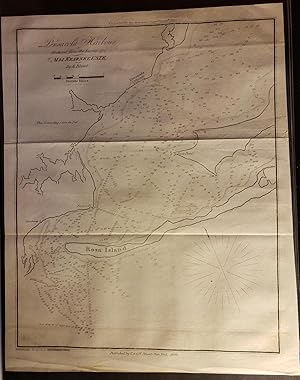
Original Map - "Pensacola Harbour. Reduced form the Survey of Maj. Kearney, U.S.T.E. by E. Blunt."
Editore: E. and G. W. Blunt, New York, 1841
Da: Barry Cassidy Rare Books, Sacramento, CA, U.S.A.
Valutazione del venditore 5 su 5 stelle
Mappa
No Binding. Condizione: Collectible-Very Good. Original publisher's black and white engraved nautical chart showing Pensacola Harbor in Florida. Chart with margins measures 9" x 11 1/4"; actual chart area measures 8" x 10." Chart is very clean and intact. There are a couple horizontal fold lines (chart was folded into thirds). Title and scale of distance in statute miles in lower-right corner. "Engraved for the American Coast Pilot, 14th Ed." printed above the chart. "Printed by W. Hooker, 202 Water Street.; Published by E. & G.W. Blunt. New York. 1841.; Plan Engd. by Hatch." printed beneath the chart. Chart includes numbers showing water depths (soundings) in feet, a compass rose, and various navigational aids. The chart also shows geographical features such as Rosa Island, Tartar Point, and Deer Point. Edmund Blunt (1770-1862) was a publisher of nautical charts and books and printed the first edition of the American Coast Pilot in 1796. Around 1827, Blunt retired and his sons took over the company and continued his work as a publisher of high-quality sea charts. The Blunts were also known for their collaboration with the U.S. Coast Survey which allowed their charts to be up-to-date.