
Importo totale (1 articolo articoli):
Destinazione ordine:

j rapkin (611 risultati)
Vai alla pagina principale dei risultati di ricerca
Tipo di articolo
- Tutti gli articoli
- Libri (303)
- Riviste e Giornali
- Fumetti
- Spartiti
- Arte, Stampe e Poster (2)
- Fotografie
- Mappe (291)
-
Manoscritti e
Collezionismo cartaceo (15)
Condizioni
Legatura
Ulteriori caratteristiche
Spedizione gratuita
Paese del venditore
Valutazione venditore
-

A Woman Doctor's Guide to PMS: Essential Facts and Up to the Minute Information on PMS (Books for Women by Women)
Editore: Hyperion, 1994
ISBN 10: 156282810XISBN 13: 9781562828103
Libro
Condizione: Very Good. Very Good condition. A copy that may have a few cosmetic defects. May also contain light spine creasing or a few markings such as an owner's name, short gifter's inscription or light stamp. Bundled media such as CDs, DVDs, floppy disks or access codes may not be included.
Ulteriori offerte da altri venditori AbeBooks
Nuovo - A partire da EUR 91,57
Usato - A partire da EUR 5,40
Scopri anche Brossura
-

PMS : A Woman Doctor's Guide: Essential Facts and Up-to-the-Minute Information on Premenstrual Syndrome
Editore: Kensington Publishing Corporation, 2000
ISBN 10: 1575666022ISBN 13: 9781575666020
Libro
Condizione: Very Good. Revised edition. Ships from the UK. Former library book; may include library markings. Used book that is in excellent condition. May show signs of wear or have minor defects.
Ulteriori offerte da altri venditori AbeBooks
Usato - A partire da EUR 4,29
-
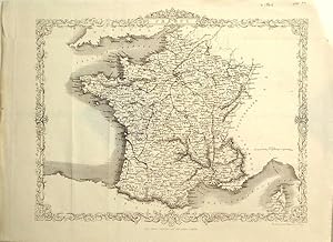
Single sheet. Uncoloured map with elaborate border. Original folds. 32 x 26 cm.
-
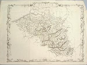
Single sheet. Uncoloured map with elaborate border. Original folds and a few creases and a few marginal repairs 34 x 26 cm.
-
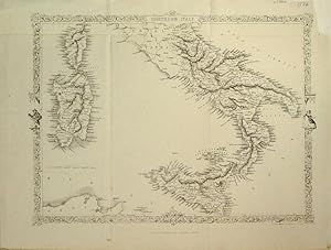
Single sheet. Uncoloured map south of the Papal States with Sicily, Corsica and Sardinia with elaborate border including figures. Just one railway line from Capua to Nola, a distance of 24 miles. Original folds. Very nice condition. 32 x 24 cm.
-

Map Of England & Wales With Original Outline Colour
Editore: J & F. Tallis, London, 1851
Prima edizione
Paperback. Condizione: Fair. First Edition. The Map With Some Original Outline Colour And With Finely Engraved Decorative Vignette Views Drawn By N. Whitlock And Engraved By J. Rogers Including London, Oxford, Portsmouth Harbour, Doncaster Race Ground, Etc, All Contained Within Decorative Engraved Borders. The Map Also With Engraved Printed Title And Separate Scale Of Distance. Image Size Approx. 245mm X 330mm (9.5in X 13in) With Margins. A little foxed and thumbed. Scribble in pencil on rear. Small ink mark on sussex. Book.
-
FACSIMILE OF 19th CENTURY PLAN OF BRADFORD, WEST YORKSHIRE
Data di pubblicazione: 1980
Da: K Books Ltd ABA ILAB, York, YORKS, Regno Unito
Membro dell'associazione: ABA ILAB PBFA
Valutazione venditore:

Libro
No Binding. Condizione: Very Good. J Rapkin (illustratore). Facsimile. Facsimile of a Plan of Bradford, West Yorkshire engraved by Rapkin, in a decorative border, inset with small engravings of Airedale College, St George's Hall, churches, the cemetery, the Infirmary and the Terminus of the Bradford and Halifax Railway. Printed on thin card. This will be posted rolled, in a tube.
-
Independent Tartary [Antique Map]
Editore: The London Printing and Publishing Company, London, 1855
Da: Books & Bidders Antiquarian Booksellers, Cleveland, OH, U.S.A.
Valutazione venditore:
Mappa
Condizione: Very Good. [Map]. Original steel engraved map with decorative boarder and vignettes. Map size with central vertical fold is approx. 11 x 14 inches. Antique map of "Independent Tartary" N.D. (no date, circa 1855). Vignettes of Tartars on a Journey, The Bride Chase, and The Tent. Map scale in British miles. Map drawn and engraved by J. Rapkin, with illustrations by W. Bragg and engraved by J. Rogers. Contemporary pen outlining in color. By 1865 Tallis was among the last of the publishers of beautifully decorated hand engraved maps. Shows some expected page toning and light wear at corners. Map.
-

Guidelines for Successful Exhibiting
Editore: London, 1991
ISBN 10: 1871777011ISBN 13: 9781871777017
Libro
Broschiert. (Re-printed 1991 (first published March 1985) Published by the British Philatelic Trust in conjunction with the British Philatelic Federation, Melville and Youth Committe, British Philatelic Centre, London. 28 pp. -- Book in good to very good condition, no writings, etc. 0.0.
-
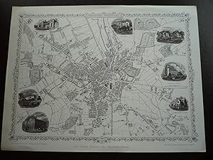
Map: Bradford, Yorkshire.
Editore: The London Printing and Publishing Company, London. N.d. (1880s) (1960s)., 1960
Mappa
No Binding. Condizione: Fine. Limited Edition. Reproduction plan or map of Bradford in Fine condition, 1 page, large quarto. The plan was drawn and engraved by J. Rapkin and the illustrations drawn and engraved by H. Winkles. Probably from the 1880s. Has 7 illustrations with the plan of churches, Infirmary, Terminus of the Bradford and Halifax Railway. Overall size is 14"x10.5". Ideal for framing.
-
Holland, antique map with vignette views
Editore: John Tallis & Co., London, 1854
Da: Antipodean Books, Maps & Prints, ABAA, Garrison, NY, U.S.A.
Membro dell'associazione: ABAA ANZAAB ESA ILAB
Valutazione venditore:

Maps. Steel engraved map from the famous Victorian publisher John Tallis, well-known for the attractive vignette views surrounding the maps, which illustrate the peoples & customs of the region. 9 3/4 x 13 1/2" plus margins. Attractive decorative border around edge, very good condition.
-
Turkey in Europe, antique map with vignette views
Editore: John Tallis & Co., London, 1854
Da: Antipodean Books, Maps & Prints, ABAA, Garrison, NY, U.S.A.
Membro dell'associazione: ABAA ANZAAB ESA ILAB
Valutazione venditore:
Maps. Steel engraved map from the famous Victorian publisher John Tallis, well-known for the attractive vignette views surrounding the maps, which illustrate the peoples & customs of the region. 12 1/2 x 10" plus margins. Attractive decorative border around edge, period outline color, very good condition.
-
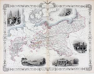
Prussia, antique map with vignette views
Editore: John Tallis & Co., London, 1854
Da: Antipodean Books, Maps & Prints, ABAA, Garrison, NY, U.S.A.
Membro dell'associazione: ABAA ANZAAB ESA ILAB
Valutazione venditore:
Maps. Steel engraved map from the famous Victorian publisher John Tallis, well-known for the attractive vignette views surrounding the maps, which illustrate the peoples & customs of the region. 12 1/2 x 10" plus margins. Attractive decorative border around edge, period outline color, very good condition.
-
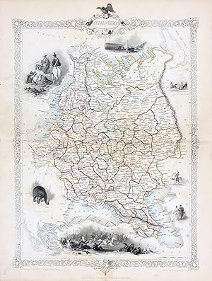
Russia in Europe, antique map with vignette views
Editore: John Tallis & Co., London, 1854
Da: Antipodean Books, Maps & Prints, ABAA, Garrison, NY, U.S.A.
Membro dell'associazione: ABAA ANZAAB ESA ILAB
Valutazione venditore:
Maps. Steel engraved map from the famous Victorian publisher John Tallis, well-known for the attractive vignette views surrounding the maps, which illustrate the peoples & customs of the region. 9 1/2 x 13 1/2" plus margins. Attractive decorative border around edge, period outline color, very good condition.
-
Belgium, antique map with vignette views
Editore: John Tallis & Co., London, 1854
Da: Antipodean Books, Maps & Prints, ABAA, Garrison, NY, U.S.A.
Membro dell'associazione: ABAA ANZAAB ESA ILAB
Valutazione venditore:
Maps. Steel engraved map from the famous Victorian publisher John Tallis, well-known for the attractive vignette views surrounding the maps, which illustrate the peoples & customs of the region. 12 1/2 x 10" plus margins. Attractive decorative border around edge, original hand color. Very good condition.
-
British Guayana, antique map with vignette views
Editore: John Tallis & Co., London, 1854
Da: Antipodean Books, Maps & Prints, ABAA, Garrison, NY, U.S.A.
Membro dell'associazione: ABAA ANZAAB ESA ILAB
Valutazione venditore:
Maps. Steel engraved map from the famous Victorian publisher John Tallis, well-known for the attractive vignette views surrounding the maps, which illustrate the peoples & customs of the region. Vignettes include: Georgetown, Christmas Cataract, New Amsterdam, and Ataraipu or the Devil's Rock. 10 x 12 1/2" plus margins. Attractive decorative border around edge, period outline color, very good condition.
-
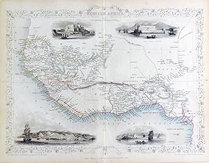
Western Africa, antique map with vignette views
Editore: John Tallis & Co., London, 1854
Da: Antipodean Books, Maps & Prints, ABAA, Garrison, NY, U.S.A.
Membro dell'associazione: ABAA ANZAAB ESA ILAB
Valutazione venditore:
Maps. Steel engraved map from the famous Victorian publisher John Tallis, well-known for the attractive vignette views surrounding the maps, which illustrate the peoples & customs of the region. 12 1/2 x 10" plus margins. Attractive decorative border around edge, period outline color, very good condition.
-
Belgium, antique map with vignette views
Editore: John Tallis & Co., London, 1854
Da: Antipodean Books, Maps & Prints, ABAA, Garrison, NY, U.S.A.
Membro dell'associazione: ABAA ANZAAB ESA ILAB
Valutazione venditore:
Maps. Steel engraved map from the famous Victorian publisher John Tallis, well-known for the attractive vignette views surrounding the maps, which illustrate the peoples & customs of the region. 12 1/2 x 10" plus margins. Attractive decorative border around edge, original hand color. Very good condition.
-
Russia in Europe, antique map with vignette views
Editore: John Tallis & Co., London, 1854
Da: Antipodean Books, Maps & Prints, ABAA, Garrison, NY, U.S.A.
Membro dell'associazione: ABAA ANZAAB ESA ILAB
Valutazione venditore:
Maps. Steel engraved map from the famous Victorian publisher John Tallis, well-known for the attractive vignette views surrounding the maps, which illustrate the peoples & customs of the region. 9 1/2 x 13 1/2" plus margins. Attractive decorative border around edge, period outline color, small archival repair at center, o/w very good condition.
-
Germany, antique map with vignette views
Editore: John Tallis & Co., London, 1854
Da: Antipodean Books, Maps & Prints, ABAA, Garrison, NY, U.S.A.
Membro dell'associazione: ABAA ANZAAB ESA ILAB
Valutazione venditore:
Maps. Steel engraved map from the famous Victorian publisher John Tallis, well-known for the attractive vignette views surrounding the maps, which illustrate the peoples & customs of the region. 9 1/2 x 13 1/2" plus margins. Attractive decorative border around edge, period outline color, very good condition.
-
New Zealand [Antique Map]
Editore: John Tallis, London, 1851
Da: Books & Bidders Antiquarian Booksellers, Cleveland, OH, U.S.A.
Valutazione venditore:
Mappa
Condizione: Good. [New Zealand Map]. Original steel engraved map with decorative boarder and vignettes. Map size with central vertical fold is 14 x 11 inches. Antique map of "New Zealand" by John Tallis & Company, circa 1851. Vignettes of Auckland, Mount Egmont from New Plymouth, Wellington, and Indigenous person. Map drawn and engraved by John Rapkin, with illustrations by H. Warren and engraved by J.B. Allen. Contemporary pen outlining in color and pale blue coastline wash. By 1865 Tallis was among the last of the publishers of beautifully decorated hand engraved maps. Trimmed at top and bottom, with some light expected page toning. Map.
-
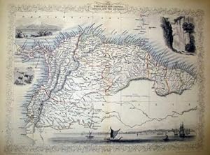
Venezuela, New Granada, Equador, and The Guayanas, antique map with vignette views
Editore: John Tallis & Co., London, 1854
Da: Antipodean Books, Maps & Prints, ABAA, Garrison, NY, U.S.A.
Membro dell'associazione: ABAA ANZAAB ESA ILAB
Valutazione venditore:
Maps. Steel engraved map from the famous Victorian publisher John Tallis, well-known for the attractive vignette views surrounding the maps, which illustrate the peoples & customs of that region. 10 x 13 1/2" plus margins. Attractive decorative border around edge, period outline color, very good condition.
-
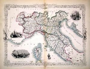
Northern Italy, antique map with vignette views
Editore: John Tallis & Co., London, 1854
Da: Antipodean Books, Maps & Prints, ABAA, Garrison, NY, U.S.A.
Membro dell'associazione: ABAA ANZAAB ESA ILAB
Valutazione venditore:
Maps. Map of Northern Italy ending in Naples and including Corsica. Steel engraved map from the famous Victorian publisher John Tallis, well-known for the attractive vignette views surrounding the maps, which illustrate the peoples & customs of that region. 10 x 13 1/2" plus margins. Attractive decorative border around edge, period outline color, very good condition.
-
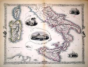
Southern Italy, antique map with vignette views
Editore: John Tallis & Co., London, 1854
Da: Antipodean Books, Maps & Prints, ABAA, Garrison, NY, U.S.A.
Membro dell'associazione: ABAA ANZAAB ESA ILAB
Valutazione venditore:
Maps. Map of Southern Italy from Rome down and including Corsica, Sardinia, and Sicily. Steel engraved map from the famous Victorian publisher John Tallis, well-known for the attractive vignette views surrounding the maps, which illustrate the peoples & customs of that region. 10 x 13 1/2" plus margins. Attractive decorative border around edge, period outline color, very good condition.
-
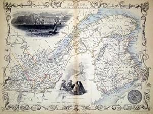
East Canada and New Brunswick, antique map with vignette views
Editore: John Tallis & Co., London, 1854
Da: Antipodean Books, Maps & Prints, ABAA, Garrison, NY, U.S.A.
Membro dell'associazione: ABAA ANZAAB ESA ILAB
Valutazione venditore:
Maps. Map of New Brunswick and a portion of Quebec extending east to Montreal. Steel engraved map from the famous Victorian publisher John Tallis, well-known for the attractive vignette views surrounding the maps, which illustrate the peoples & customs of that region. 10 x 13 1/2" plus margins. Attractive decorative border around edge, period outline color, very good condition.
-
Chili and La Plata, antique map with vignette views
Editore: John Tallis & Co., London, 1854
Da: Antipodean Books, Maps & Prints, ABAA, Garrison, NY, U.S.A.
Membro dell'associazione: ABAA ANZAAB ESA ILAB
Valutazione venditore:
Maps. Map of Chile with vignettes of travelling post, the Gobernador, the Grand Square of Buenos Ayres, Water Seller of Buenos Ayres and Rattlesnake. Steel engraved map from the famous Victorian publisher John Tallis, well-known for the attractive vignette views surrounding the maps, which illustrate the peoples & customs of that region. 10 x 13 1/2" plus margins. Attractive decorative border around edge, period outline color, very good condition.
-
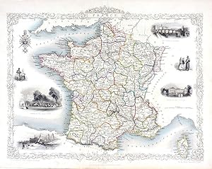
France, antique map with vignette views
Editore: John Tallis & Co., London, 1854
Da: Antipodean Books, Maps & Prints, ABAA, Garrison, NY, U.S.A.
Membro dell'associazione: ABAA ANZAAB ESA ILAB
Valutazione venditore:
Maps. Steel engraved map from the famous Victorian publisher John Tallis, well-known for the attractive vignette views surrounding the maps, which illustrate the peoples & customs of the region. 12 1/2 x 10" plus margins. Attractive decorative border around edge, period outline color, very good condition.
-
Venezuela, New Granada, Equador, and The Guayanas, antique map with vignette views
Editore: John Tallis & Co., London, 1854
Da: Antipodean Books, Maps & Prints, ABAA, Garrison, NY, U.S.A.
Membro dell'associazione: ABAA ANZAAB ESA ILAB
Valutazione venditore:
Maps. Steel engraved map from the famous Victorian publisher John Tallis, well-known for the attractive vignette views surrounding the maps, which illustrate the peoples & customs of that region. 10 x 13 1/2" plus margins. Attractive decorative border around edge, period outline color, very good condition.
-
France, antique map with vignette views
Editore: John Tallis & Co., London, 1854
Da: Antipodean Books, Maps & Prints, ABAA, Garrison, NY, U.S.A.
Membro dell'associazione: ABAA ANZAAB ESA ILAB
Valutazione venditore:
Maps. Steel engraved map from the famous Victorian publisher John Tallis, well-known for the attractive vignette views surrounding the maps, which illustrate the peoples & customs of the region. 12 1/2 x 10" plus margins. Attractive decorative border around edge, period outline color, dusty on vignettes, o/w good condition.

![Immagine del venditore per Independent Tartary [Antique Map] venduto da Books & Bidders Antiquarian Booksellers](https://pictures.abebooks.com/inventory/md/md31800635682.jpg)
![Immagine del venditore per New Zealand [Antique Map] venduto da Books & Bidders Antiquarian Booksellers](https://pictures.abebooks.com/inventory/md/md31800637588.jpg)