
Map saudi arabia (10 risultati)

Editore: [Dhahran, Aramco / USGS, 1953]., 1953
- Rilegato
Da: Antiquariat INLIBRIS Gilhofer Nfg. GmbH, Vienna, A, AustriaAntiquariat INLIBRIS Gilhofer Nfg. GmbH
Contatta il venditoreVenditore con 5 stelleCondizione: Usato
EUR 8500,00
EUR 30,00 spedizioneSpedito da Austria a U.S.A.Quantità: 1 disponibili
760 x 750 mm. Scale 1:1,000,000. Relief shown by hachures, spot heights, submarine contours, airports and airstrips, mining activity, and land routes. Key in English. Printed on cloth. Blueprint map of Saudi Arabia covering 20-26° N and 38-45° E, extending from the Nejd to the Red Sea coast including Jeddah and Yanbu al-Nakhal.…It pays particular attention to geological features, showing the lava fields of Harrat Rahat, Harrat Kishb, Harrat Khaybar, Harrat Nawasif, Harrat Buqum and Harrat Hadan, as well as the Uruq Subay dunes and the tribal areas of Bilad Zahran and Bilad Ghamid. Among the most prominent labelled cities are Mecca with its environs (Muna, Shumaysi), Medina, Jeddah and Taif; the Darb al-Hijaz (Riyad-Jeddah Road) is named. - The sheet was prepared as a working document by Aramco and the US Geological Survey to help them in the early stages of comprehensive nationwide mapping and exploration work for the Saudi Government. - Slightly toned along folding lines and right margin.

World aeronautical chart (446) Wadi Sirhan.
[MAP - SAUDI ARABIA - JORDAN]. USAF aeronautical chart and information service.
Editore: USAF aeronautical chart and information service,, Washington, DC,, 1958
Da: Antiquariaat FORUM BV, Houten, Paesi BassiAntiquariaat FORUM BV
Contatta il venditoreVenditore con 5 stelleCondizione: Usato
EUR 950,00
EUR 25,00 spedizioneSpedito da Paesi Bassi a U.S.A.Quantità: 1 disponibili
Pilot's map of Wadi Sirhan in the border region of Iraq, Saudi Arabia and Jordan. The map shows the concave and zigzagging border between Saudi Arabia and Jordan before it revision in 1965. The indefinite nature of the borders is clearly visible on the map in the changed and crossed-out borderlines and the notations "boundary ap…proximate" and "boundary approximate". Several areas are marked as "danger area" or "prohibited area". Stamped "obsolete for use in aviation", otherwise in excellent condition. Colour printed map, 56 x 73.5 cm, with a legend printed on the back. Scale 1:1,000,000.
 Altre immagini
Editore: [Saudi Arabia, 1960s]., 1960
Da: Antiquariat INLIBRIS Gilhofer Nfg. GmbH, Vienna, A, AustriaAntiquariat INLIBRIS Gilhofer Nfg. GmbH
Contatta il venditoreVenditore con 5 stelleCondizione: Usato
EUR 1500,00
EUR 30,00 spedizioneSpedito da Austria a U.S.A.Quantità: 1 disponibili
490 x 695 mm. Colour-printed map. Scale ca. 1:5,000,000. Folding map of the main roads of Saudi Arabia, Qatar, Bahrain and the United Arab Emirates. Details international boundaries, primary and secondary roads, roads under construction, proposed roads, trails and railroads along with airports and desert territory. A text column… to the left of the map provides facts and figures on the Bahrain archipelago, Qatar, the Emirati coastline, Abu Dhabi and Dubai, the latter being considered "an outstanding example of self-help and opportunism in improbable circumstances". - Town plans of Sharjah, Kuwait and Dubai, along with a road map of the Emirates, a pipeline map of Qatar, 3 photographic city views of Dubai and Kuwait, a map of Musandam Peninsula and some publisher's advertisements on the reverse. - A few minor tears to folds; otherwise very well preserved.
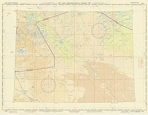
USAF aeronautical chart and information service. World aeronautical chart (446) Wadi Sirhan.
[Map - Saudi Arabia - Jordan].
Editore: Washington, D.C., AAF Aeronautical Chart Service, 1945., 1945
- Prima edizione
- Mappa
Da: Antiquariat INLIBRIS Gilhofer Nfg. GmbH, Vienna, A, AustriaAntiquariat INLIBRIS Gilhofer Nfg. GmbH
Contatta il venditoreVenditore con 5 stelleCondizione: Usato
EUR 750,00
EUR 30,00 spedizioneSpedito da Austria a U.S.A.Quantità: 1 disponibili
Colour-printed map, 730 x 560 mm. Scale 1:1,000,000. On verso: legend, aeronautical information, and index map. First edition. Pilot's map of Wadi Sirhan in the border region of Iraq, Saudi Arabia and Transjordan. It shows international boundaries populated places, roads and tracks, railways, wireless telegraph stations, forts,…wadis, wells, vegetation and terrain features. Shows also parts of Transjordan and Iraq, including the zigzagging border between Saudi Arabia and Transjordan. - In excellent condition.
 Altre immagini
Editore: [Saudi Arabia,, 1960
Da: Antiquariaat FORUM BV, Houten, Paesi BassiAntiquariaat FORUM BV
Contatta il venditoreVenditore con 5 stelleCondizione: Usato
EUR 1800,00
EUR 25,00 spedizioneSpedito da Paesi Bassi a U.S.A.Quantità: 1 disponibili
Folding map of the main roads of Saudi Arabia, but depicting the whole Arabian peninsula. On the left of the map text giving information on the climate, Riyadh, Jeddah, Damman, Taif, the Akrama water dam, Alkhobar, the telephone system and the exchange rates. The reverse side of the map includes plans of Jeddah, Riyadh, Dammam a…nd 8 photographic city views. Some minor tears at the folds, front partly discoloured and browned, but otherwise in good condition. Colour-printed folding map (48 x 69.5 cm) of the Arabian peninsula (scale: ca. 1: 5,000,000), with on the back a city map of Jeddah, a plan of the main business quarter of Riyadh, a city plan of Dammam(?), a distance table and 8 photographic city views.
 Altre immagini
Editore: printed at Golden block works,, Karachi, Pakistan,, 1970
Da: Antiquariaat FORUM BV, Houten, Paesi BassiAntiquariaat FORUM BV
Contatta il venditoreVenditore con 5 stelleCondizione: Usato
EUR 1750,00
EUR 25,00 spedizioneSpedito da Paesi Bassi a U.S.A.Quantità: 1 disponibili
Folding map of the main roads of Saudi Arabia, but depicting the whole Arabian peninsula and including the Sultanate of Oman, meaning the present state must have been published in or after 1970. On the left of the map text giving information on the climate, Riyadh, Jeddah, Damman, Taif, the Akrama water dam, Alkhobar, the teleph…one system and the exchange rates. The reverse side of the map includes plans of Jeddah, Riyadh, Dammam and 8 photographic city views. In very good condition. Colour-printed folding map (48 x 69.5 cm) of the Arabian peninsula (scale: ca. 1:5,000,000), with on the back a city map of Jeddah, a plan of the main business quarter of Riyadh, a city plan of Dammam(?), a distance table and 8 photographic city views.

USAF aeronautical chart and information service. World aeronautical chart (446) Wadi Sirhan.
[Map - Saudi Arabia - Jordan].
Editore: Washington, DC, USAF aeronautical chart and information service, 1958., 1958
Da: Antiquariat INLIBRIS Gilhofer Nfg. GmbH, Vienna, A, AustriaAntiquariat INLIBRIS Gilhofer Nfg. GmbH
Contatta il venditoreVenditore con 5 stelleCondizione: Usato
EUR 950,00
EUR 30,00 spedizioneSpedito da Austria a U.S.A.Quantità: 1 disponibili
Colour-printed map, 560 x 735 mm, with a legend printed on the back. Scale 1:1,000,000. Pilot's map of Wadi Sirhan in the border region of Iraq, Saudi Arabia and Jordan. The map shows the concave and zigzagging border between Saudi Arabia and Jordan before its revision in 1965. The indefinite nature of the borders is clearly vis…ible on the map in the changed and crossed-out borderlines and the notations "boundary approximate". Several areas are marked as "danger area" or "prohibited area". - Stamped "obsolete for use in aviation", otherwise in excellent condition.

Editore: Dammam, Mutawa Press, [early 1980s]., 1980
Da: Antiquariat INLIBRIS Gilhofer Nfg. GmbH, Vienna, A, AustriaAntiquariat INLIBRIS Gilhofer Nfg. GmbH
Contatta il venditoreVenditore con 5 stelleCondizione: Usato
EUR 1000,00
EUR 30,00 spedizioneSpedito da Austria a U.S.A.Quantità: 1 disponibili
Colour-printed map, 590 x 855 mm. Bilingual road map of the Arabian Peninsula for Aramco employees. Focused on Saudi Arabia, the map shows the main roads, as well as surfaced roads, trails, roads under constructions and even proposed roads. A list titled "hints for survival" mentions extremely logical traffic rules such as "come… to a complete stop at stop signs and observe stop-and-go signals" and "observe speed laws in the community where you live as well as on the highway". Placing common traffic rules under the header "hints for survival" makes one fear the worst for Saudi Arabian traffic in this period. The Arabic side of the map contains the same "hints" as well as a list of road signs in Arabic and English. - In very good condition.

Tactical Commanders' Terrain Analysis Ras Tanura Area Terrain Analysis Map AP-1-380-46-65-INT. TacCTA Ras Tanura Saudi Arabia.
1965 Army Map Service Intelligence Map of Ras Tanura, Saudi Arabia and Environs
- Mappa
Da: Geographicus Rare Antique Maps, Brooklyn, NY, U.S.A.Geographicus Rare Antique Maps
Contatta il venditoreVenditore con 4 stelleCondizione: Usato
EUR 1512,80
EUR 14,86 spedizioneSpedito in U.S.A.Quantità: 1 disponibili
Very good. Light wear along original fold lines. Size 36.25 x 28 Inches. This is a 1965 Tactical Commanders' Terrain Analysis (TacCTA) map of Ras Tanura, Saudi Arabia, prepared by the Army Map Service for the Defense Intelligence Agency. The area is home to a large Saudi Aramco oil refinery and port, the main avenue for Saudi Ar…abia's oil exports, and the map would have been vital for any military operation that might take place there. A Closer Look This map covers Ras Tanura and environs on the east coast of Saudi Arabia. A grid overlies the map, dividing it into squares of 100,000 meters, as explained in the diagram at the bottom. Color-shading and a series of numbers and letters are used to indicate the nature of terrain, its suitability for trucks and tanks, and the level of cover and concealment (generally very little). A similar table at the bottom-right gives related information for airstrips, beaches, and piers, which would be essential in any military operation. (The most favorable landing sites are marked in blue around the refinery and adjacent settlements.) Additional information on roads, terrain, flora, settlements, and human-built structures such as mosques, cemeteries, and wells is indicated according to the legend at bottom-left. As on land, remarkably detailed information is provided on the waters around Ras Tanura, including soundings, bottoms, and the location of fishing weirs. The verso provides additional information and photographs, focusing on the refinery and potential landing zones for ships and airplanes. Mapping Military Intelligence This map was produced by the Defense Intelligence Agency (DIA), created in 1961 and housed within the Department of Defense under the leadership of the Under Secretary of Defense for Intelligence. The agency is thus independent of both the military services (whose intelligence outfits it took over many functions from) and the Central Intelligence Agency. The DIA is tasked with providing intelligence information to the Secretary of Defense, Joint Chiefs of Staff, and military commanders. The present map reflects the assiduousness of the agency's work, with granular detail and analysis that would be critical in any military operation at Ras Tanura. Given the importance of Ras Tanura for global oil supply and the highly unsettled state of regional politics (including a dispute within the Saudi monarchy between King Saud and his half-brother Faisal, who deposed the former in 1964) set against the background of the Cold War (1947 - 1991), one can imagine that this map would have been essential for safeguarding the Aramco facilities at Ras Tanura in the event of a military conflict. Ras Tanura and the Oil Industry Ras Tanura is a settlement set on a peninsula jutting out into the Persian Gulf, located between Bahrain and Kuwait, forming the top portion of Tarut Bay. Its history is closely tied to the oil industry as it is home to major refinery and port facilities. When large quantities of oil were first discovered at nearby Dammam in 1938, the California Arabian Standard Oil Company (CASOC), forerunner to Saudi Aramco, built a pipeline to Ras Tanura, and a refining plant was put into operation. During World War II (1939 - 1945), a new, wider pipeline and a much larger refinery were constructed to support the war effort. Export capacity continued to expand, reaching 1 million barrels per day in 1971 and roughly 6 million barrels per day nowadays, some 90% of Saudi Arabia's oil exports, making Ras Tanura the largest oil port in the world. CASOC/Aramco also built a relatively luxurious residential compound near the refinery at Najmah (Nejma here) for American workers, which has in the decades since come to house a more cosmopolitan mix of employees, including many Saudis. The adjacent town of Rahima (Rahaima here) historically housed Saudi and other non-Western workers, though these divisions were not always absolute. Other nearby facilities, such as a hospital and golf course.

/ [Map of the Prophet's Mosque (Haram Sharif) with All Sacred Places, Military Buildings and Main Squares Showing Topography of the City of Medina Al-Munawwarah with a Legend]
1880 Sherif Abd al-Mu??alib Manuscript Map of Medina (Madinah), Saudi Arabia
- Firmato
- Mappa
Da: Geographicus Rare Antique Maps, Brooklyn, NY, U.S.A.Geographicus Rare Antique Maps
Contatta il venditoreVenditore con 4 stelleCondizione: Usato
EUR 85.725,15
EUR 14,86 spedizioneSpedito in U.S.A.Quantità: 1 disponibili
Good. Even overall toning. Some edge wear. Size 28 x 41 Inches. A seminal map. This large-scale manuscript map is the first scientific survey of the Islamic holy city of Medina (??????? ??????? / Madinah), in modern-day Saudi Arabia. The map was compiled for Abd al-Mutalib ibn Ghalib, Emir and Grand Sharif of Mecca, known for hi…s pro-slavery anti-Ottoman positions, as well as for his modernization of infrastructure in both Mecca and Medina. A Closer Look The map is hand-drawn in black ink with watercolor wash. It is oriented to the north. The Prophet's Mosque Al Masjid an Nabawi ?????? ?????? appears prominently just to the right of center, with a large separate key at bottom-center elaborating on its main sections, veneration sites, and monuments. The map details an array of important structures, including offices, hammams, the general fountain, separate fountains for men and women (blue), an Egyptian Palace, a military hospital, and a fortress. This last is detailed with a garden, kitchen, officer's quarters and commissary (army store), and imperial military quarters. Tiny side streets, charmingly illustrated smaller square streets with palm trees, illustrate the city's rapid expansion and urbanization beyond the city walls. Gardens and important courtyards (Courtyard of the State, Royal Courtyard,), are also noted. Al-Baqi Cemetery One significant feature of this map is its detailed representation of Al-Baqi Cemetery (Jannat al-Baqi) ?????????? located on the right-hand side of the map (green wash), where the six most important tombs are identified and described in a key above. The cemetery is the oldest in the Hejazi Region. The site was personally selected by the Prophet as the site for the burial of his companion Uthman ibn Maz'un, making it the first Islamic cemetery in Medina. Over the years, it has become the burial site for numerous members of the Prophet's family, including his wives, daughters, and grandson Hasan ibn Ali. Many of the Prophet's companions (Sahabah) are also buried here, making it a place of great reverence for Muslims. The original cemetery was partially demolished in 1926 by the Saudi government in an attempt to promote a return to a more austere form of Islam, emphasizing simplicity and avoiding the veneration of graves. This action sparked controversy and grief among many Muslims who felt a deep connection to the historical and spiritual heritage of the cemetery. Very few representations of the cemetery survive that predate this event - this being, perhaps, the best. Today, Al-Baqi is enclosed and well-maintained, with clear pathways for visitors to walk and pay their respects. Historical Context This is one of two known maps of Medina made in the 19th century. Both were produced at the order of Abd al-Mutalib ibn Ghalib, the first c. 1853 during his second reign (1851 - 1856) as Emir and Grand Sharif of Mecca (see: Ömer Faruk Yilmaz, Belgelerle Osmanl? devrinde Hicaz, 2008 and Atef Alshehri, Ottoman Spatial Organization of the pre-modern City of Medina, ABE Journal, 2018), and this one in 1880, during his third reign (1880 - 1881). The present map is by far the superior, benefiting from the first scientific survey of the city, and thus is significantly larger and richer in detail and general content. Both are administrative plans, intended for the management of the holy city, civic infrastructure development, and Abd al-Mutalib ibn Ghalib's anti-Ottoman military ambitions. The period of its manufacture coincides with waning Ottoman hegemony and the rise of the Second Saudi State (1240 - 1309 AH / 1824 - 1891 AD). Although the Arabian peninsula was under Ottoman suzerainty, the pilgrimage centers, Mecca and Medina, operated autonomously under the Emir and Grand Sharif of Mecca. As both religious sites and semi-autonomous cities, Mecca and Medina became centers of attempts to drive the Ottomans out of Arabia. Abd al-Mutalib ibn Ghalib was staunchly anti-Ottoman, allying with the puritanica. Signed by Author(s).


