Importo totale (1 articolo articoli):
Destinazione ordine:

northrup matthews (99 risultati)
Vai alla pagina principale dei risultati di ricerca
Filtri di ricerca
Tipo di articolo
- Tutti i tipi di prodotto
- Libri (84)
- Riviste e Giornali (Nessun altro risultato corrispondente a questo perfezionamento)
- Fumetti (Nessun altro risultato corrispondente a questo perfezionamento)
- Spartiti (Nessun altro risultato corrispondente a questo perfezionamento)
- Arte, Stampe e Poster (Nessun altro risultato corrispondente a questo perfezionamento)
- Fotografie (Nessun altro risultato corrispondente a questo perfezionamento)
- Mappe (15)
- Manoscritti e Collezionismo cartaceo (Nessun altro risultato corrispondente a questo perfezionamento)
Condizioni Maggiori informazioni
Legatura
Ulteriori caratteristiche
- Prima ed. (3)
- Copia autograf. (Nessun altro risultato corrispondente a questo perfezionamento)
- Sovracoperta (Nessun altro risultato corrispondente a questo perfezionamento)
- Con foto (49)
- Non Print on Demand (61)
Lingua (2)
Spedizione gratuita
Paese del venditore
Valutazione venditore
-

A Little Guide to Niagara Falls
Da: Rarewaves.com USA, London, LONDO, Regno Unito
Valutazione del venditore 5 su 5 stelle

EUR 18,64
Spedizione gratuita
Spedito da Regno Unito a U.S.A.Quantit�: Pi� di 20 disponibili
Aggiungi al carrelloPaperback. Condizione: New.
-

Free Niagara Classic Reprint
Da: PBShop.store US, Wood Dale, IL, U.S.A.
Valutazione del venditore 5 su 5 stelle
PAP. Condizione: New. New Book. Shipped from UK. Established seller since 2000.
-

How to See Niagara Classic Reprint
Da: PBShop.store US, Wood Dale, IL, U.S.A.
Valutazione del venditore 5 su 5 stelle
PAP. Condizione: New. New Book. Shipped from UK. Established seller since 2000.
-
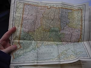
The Matthews-Northrup Up-to-Date Colored Map of CONNECTICUT (1898)
Lingua: Inglese
Editore: Matthews-Northrup, 1898
Da: Imperial Books and Collectibles, Wauwatosa, WI, U.S.A.
Valutazione del venditore 5 su 5 stelle
Mappa
Map. Condizione: Very Good. Original vintage Matthews-Northrup folded engraved map of Connecticut. Dimensions (11.75" W x 9.5" H). Eight folds. Contents clean and unmarked; small crease and chip along edge. Fold lines. Scale 1 inch = 8.5 Miles. Date 1898.
-
Matthews-Northrup Map of Maine (1901)
Lingua: Inglese
Editore: Crowell & Kirkpatrick Co., 1901
Da: Imperial Books and Collectibles, Wauwatosa, WI, U.S.A.
Valutazione del venditore 5 su 5 stelle
Mappa
Map. Condizione: Very Good. Original antique colored map of Maine by The Matthews-Northrup Co. from the Twentieth Century Peerless Atlas published by Crowell & Kirkpatrick in 1901, Plate dimensions 12" H x 9.5" wide. Includes inset of the City of Portland and Vicinity. Scale 1 inch equals 26 miles. Small closed tear along bottom edge not impacting plate. Other maps from this Atlas are listed and available.
-
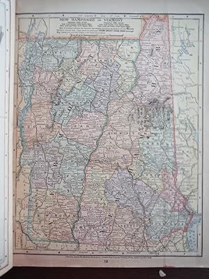
Matthews-Northrup Map of New Jersey (1901)
Lingua: Inglese
Editore: Crowell & Kirkpatrick Co.
Da: Imperial Books and Collectibles, Wauwatosa, WI, U.S.A.
Valutazione del venditore 5 su 5 stelle
Mappa
Map. Condizione: Very Good. Original antique colored map of New Jersey by The Matthews-Northrup Co. from the Twentieth Century Peerless Atlas published by Crowell & Kirkpatrick in 1901, Plate dimensions 12" H x 9.5" wide. Includes inset of the Cities of Newark and Jersey City and Vicinity. Scale 1 inch equals 15 miles. Small closed tear along bottom edge not impacting plate. On reverse side is a map of New Hampshire and Vermont. Other maps from this Atlas are listed and available.
-

The Century Atlas Map of German Empire, Southwestern Part (1897)
Lingua: Inglese
Editore: The Century Co., 1897
Da: Imperial Books and Collectibles, Wauwatosa, WI, U.S.A.
Valutazione del venditore 5 su 5 stelle
Mappa
Map. Condizione: Very Good. Authentic antique engraved color map by Matthews-Northrup Co. of German Empire, Southwestern Part from the 1897 edition of the Century Atlas of the World. Plate size of approximately 10.375? x 14.785? on a page with dimensions of 13? x 17? Light age toning in margins not impacting plate. Center crease as issued; obverse blank. Most advanced Atlas of the times. Other maps from Atlas available.
-
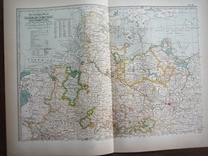
The Century Atlas Map of German Empire, Northern Part (1897)
Lingua: Inglese
Editore: The Century Co., 1897
Da: Imperial Books and Collectibles, Wauwatosa, WI, U.S.A.
Valutazione del venditore 5 su 5 stelle
Mappa
Map. Condizione: Very Good. Authentic antique engraved color map by Matthews-Northrup Co. of German Empire, Northern Part from the 1897 edition of the Century Atlas of the World. Plate size of approximately 10.375? x 14.785? on a page with dimensions of 13? x 17? Light age toning in margins not impacting plate. Center crease as issued; obverse blank. Most advanced Atlas of the times. Other maps from Atlas available.
-
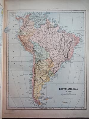
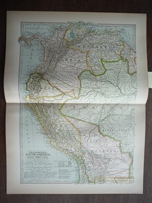
The Century Atlas Map of South America, Northwest Part (1897)
Lingua: Inglese
Editore: The Century Co., 1897
Da: Imperial Books and Collectibles, Wauwatosa, WI, U.S.A.
Valutazione del venditore 5 su 5 stelle
Mappa
Map. Condizione: Very Good. Authentic antique engraved color map by Matthews-Northrup Co. of South America, Northwest Part from the 1897 edition of the Century Atlas of the World. Plate size of approximately 10.375" x 14.785" on a page with dimensions of 13" x 17". Light age toning in margins not impacting plate. Center crease as issued; obverse blank. Most advanced Atlas of the times. Other maps from Atlas available.
-
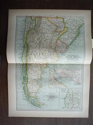
The Century Atlas Map of South America, Southern Part (1897)
Lingua: Inglese
Editore: The Century Co., 1897
Da: Imperial Books and Collectibles, Wauwatosa, WI, U.S.A.
Valutazione del venditore 5 su 5 stelle
Mappa
Map. Condizione: Very Good. Authentic antique engraved color map by Matthews-Northrup Co. of South America, Southern Part from the 1897 edition of the Century Atlas of the World. Inset of Buenos Aires, Montevideo and Vicinity and of Valparaiso, Santiago and Vicinity. Plate size of approximately 10.375" x 14.785" on a page with dimensions of 13" x 17". ight age toning in margins not impacting plate. Center crease as issued; obverse blank. Most advanced Atlas of the times. Other maps from Atlas available.
-
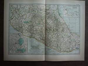
The Century Atlas Map of Mexico, Central Portion(1897)
Lingua: Inglese
Editore: The Century Co., 1897
Da: Imperial Books and Collectibles, Wauwatosa, WI, U.S.A.
Valutazione del venditore 5 su 5 stelle
Mappa
Map. Condizione: Very Good. Authentic antique engraved color map by Matthews-Northrup Co. of Mexico, Central Portion from the 1897 edition of the Century Atlas of the World. Inset of the City of Mexico and Vicinity and of Veracruz. Plate size of approximately 10.375" x 14.785" on a page with dimensions of 13" x 17". Light age toning in margins not impacting plate. Center crease as issued; obverse blank. Most advanced Atlas of the times. Other maps from Atlas available.
-
The Century Atlas Map of the Dominion of Canada and Newfoundland (1897)
Lingua: Inglese
Editore: The Century Co., 1897
Da: Imperial Books and Collectibles, Wauwatosa, WI, U.S.A.
Valutazione del venditore 5 su 5 stelle
Mappa
Map. Condizione: Very Good. Authentic antique engraved color map by Matthews-Northrup Co. of the Dominion of Canada and Newfoundland from the 1897 edition of the Century Atlas of the World. Plate size of approximately 10.375" x 14.785" on a page with dimensions of 13" x 17". Light age toning in margins not impacting plate. Center crease as issued; obverse blank. Most advanced Atlas of the times. Other maps from Atlas available.
-
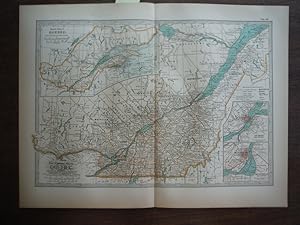
The Century Atlas Map of Quebec (1897)
Lingua: Inglese
Editore: The Century Co., 1897
Da: Imperial Books and Collectibles, Wauwatosa, WI, U.S.A.
Valutazione del venditore 5 su 5 stelle
Mappa
Map. Condizione: Very Good. Authentic antique engraved color map by Matthews-Northrup Co. of Quebec from the 1897 edition of the Century Atlas of the World. Inset of Quebec and Vicinity and of Toronto and Vicinity. Plate size of approximately 10.375" x 14.785" on a page with dimensions of 13" x 17". Light age toning in margins not impacting plate. Center crease as issued; obverse blank. Most advanced Atlas of the times. Other maps from Atlas available.
-
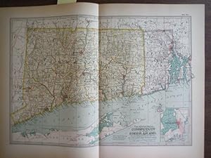
The Century Atlas, Map of Connecticut and Rhode Island (1897)
Lingua: Inglese
Editore: The Century Co., 1897
Da: Imperial Books and Collectibles, Wauwatosa, WI, U.S.A.
Valutazione del venditore 5 su 5 stelle
Mappa
Map. Condizione: Very Good. Authentic antique engraved color map by Matthews-Northrup Co. of the States of Connecticut and Rhode Island from the 1897 edition of the Century Atlas of the World. Includes inset of Newport Rhode Island. Plate size of approximately 10.375? x 14.785? on a page with dimensions of 13? x 17? Light age toning in margins not impacting plate. Center crease as issued; obverse blank. Most advanced Atlas of the times. Other maps from Atlas available.
-

Complete Handy Atlas Of The World And City Guide: Containing Maps Of Every Country On The Face Of The Globe, And The Leading Cities Of This Country
Da: GreatBookPrices, Columbia, MD, U.S.A.
Valutazione del venditore 5 su 5 stelle
EUR 22,23
Spedizione EUR 2,27
Spedito in U.S.A.Quantit�: Pi� di 20 disponibili
Aggiungi al carrelloCondizione: New.
-

Complete Handy Atlas Of The World And City Guide: Containing Maps Of Every Country On The Face Of The Globe, And The Leading Cities Of This Country (Paperback or Softback)
Lingua: Inglese
Editore: Legare Street Press 10/27/2022, 2022
ISBN 10: 1017770433 ISBN 13: 9781017770438
Da: BargainBookStores, Grand Rapids, MI, U.S.A.
Valutazione del venditore 5 su 5 stelle
Paperback or Softback. Condizione: New. Complete Handy Atlas Of The World And City Guide: Containing Maps Of Every Country On The Face Of The Globe, And The Leading Cities Of This Country. Book.
-

Complete Handy Atlas Of The World And City Guide: Containing Maps Of Every Country On The Face Of The Globe, And The Leading Cities Of This Country
Da: ThriftBooks-Atlanta, AUSTELL, GA, U.S.A.
Valutazione del venditore 5 su 5 stelle
Hardcover. Condizione: As New. No Jacket. Pages are clean and are not marred by notes or folds of any kind. ~ ThriftBooks: Read More, Spend Less.
-

The New Matthews-Northrup Global Atlas of the World at War
Editore: The World Publishing Co., 1940
Da: Basement Seller 101, Cincinnati, OH, U.S.A.
Valutazione del venditore 5 su 5 stelle
Paperback. Condizione: Fair.
-
Complete Handy Atlas Of The World And City Guide: Containing Maps Of Every Country On The Face Of The Globe, And The Leading Cities Of This Country
Da: GreatBookPrices, Columbia, MD, U.S.A.
Valutazione del venditore 5 su 5 stelle
EUR 24,42
Spedizione EUR 2,27
Spedito in U.S.A.Quantit�: Pi� di 20 disponibili
Aggiungi al carrelloCondizione: As New. Unread book in perfect condition.
-

The Matthews-Northrup Adequate Travel-Atlas of the United States (Classic Reprint)
Da: PBShop.store US, Wood Dale, IL, U.S.A.
Valutazione del venditore 5 su 5 stelle
PAP. Condizione: New. New Book. Shipped from UK. Established seller since 2000.
-
Free Niagara Classic Reprint
Da: PBShop.store UK, Fairford, GLOS, Regno Unito
Valutazione del venditore 5 su 5 stelle
EUR 24,11
Spedizione EUR 3,81
Spedito da Regno Unito a U.S.A.Quantit�: 15 disponibili
Aggiungi al carrelloPAP. Condizione: New. New Book. Shipped from UK. Established seller since 2000.
-
How to See Niagara Classic Reprint
Da: PBShop.store UK, Fairford, GLOS, Regno Unito
Valutazione del venditore 5 su 5 stelle
EUR 24,58
Spedizione EUR 3,81
Spedito da Regno Unito a U.S.A.Quantit�: 15 disponibili
Aggiungi al carrelloPAP. Condizione: New. New Book. Shipped from UK. Established seller since 2000.
-

How to See Niagara (Classic Reprint)
Da: PBShop.store US, Wood Dale, IL, U.S.A.
Valutazione del venditore 5 su 5 stelle
HRD. Condizione: New. New Book. Shipped from UK. Established seller since 2000.
-
The Matthews-Northrup Adequate Travel-Atlas of the United States (Classic Reprint)
Da: PBShop.store UK, Fairford, GLOS, Regno Unito
Valutazione del venditore 5 su 5 stelle
EUR 24,75
Spedizione EUR 4,82
Spedito da Regno Unito a U.S.A.Quantit�: 15 disponibili
Aggiungi al carrelloPAP. Condizione: New. New Book. Shipped from UK. Established seller since 2000.
-

The Matthews-Northrup Adequate Travel-Atlas of the United States (Classic Reprint)
Da: PBShop.store US, Wood Dale, IL, U.S.A.
Valutazione del venditore 5 su 5 stelle
HRD. Condizione: New. New Book. Shipped from UK. Established seller since 2000.
-
Complete Handy Atlas Of The World And City Guide: Containing Maps Of Every Country On The Face Of The Globe, And The Leading Cities Of This Country
Da: GreatBookPrices, Columbia, MD, U.S.A.
Valutazione del venditore 5 su 5 stelle
EUR 32,07
Spedizione EUR 2,27
Spedito in U.S.A.Quantit�: Pi� di 20 disponibili
Aggiungi al carrelloCondizione: New.
-

Complete Handy Atlas Of The World And City Guide: Containing Maps Of Every Country On The Face Of The Globe, And The Leading Cities Of This Country (Hardback or Cased Book)
Lingua: Inglese
Editore: Legare Street Press 10/27/2022, 2022
ISBN 10: 1017765863 ISBN 13: 9781017765861
Da: BargainBookStores, Grand Rapids, MI, U.S.A.
Valutazione del venditore 5 su 5 stelle
Hardback or Cased Book. Condizione: New. Complete Handy Atlas Of The World And City Guide: Containing Maps Of Every Country On The Face Of The Globe, And The Leading Cities Of This Country. Book.
-
How to See Niagara (Classic Reprint)
Da: PBShop.store UK, Fairford, GLOS, Regno Unito
Valutazione del venditore 5 su 5 stelle
EUR 32,92
Spedizione EUR 4,82
Spedito da Regno Unito a U.S.A.Quantit�: 15 disponibili
Aggiungi al carrelloHRD. Condizione: New. New Book. Shipped from UK. Established seller since 2000.
-
Complete Handy Atlas Of The World And City Guide: Containing Maps Of Every Country On The Face Of The Globe, And The Leading Cities Of This Country
Da: GreatBookPrices, Columbia, MD, U.S.A.
Valutazione del venditore 5 su 5 stelle
EUR 35,72
Spedizione EUR 2,27
Spedito in U.S.A.Quantit�: Pi� di 20 disponibili
Aggiungi al carrelloCondizione: As New. Unread book in perfect condition.
-

The New Matthews-Northrup Global Atlas of the World War With Invasion Marps That Cover all Possible Points of Invastion
Editore: World Publishing Company, Cleveland, OH, 1947
Da: True Oak Books, Highland, NY, U.S.A.
Membro dell'associazione: IOBA
Valutazione del venditore 5 su 5 stelle
Paperback. Condizione: Fair. 48 pages; color and B&W maps. Moderate tears on cover edges and on spine. Spine was reinforced with clear tape. Pages are clean and in VG condition. ; - Your satisfaction is our priority. We offer free returns and respond promptly to all inquiries. Your item will be carefully cushioned in bubble wrap and securely boxed. All orders ship on the same or next business day. Buy with confidence.