Philippe pretot e (29 risultati)

- Brossura
Da: California Books, Miami, FL, U.S.A.California Books
Contatta il venditoreVenditore con 4 stelleCondizione: Nuovo
EUR 16,02
Spedizione gratuitaSpedito in U.S.A.Quantità: Più di 20 disponibili
Condizione: New.
- Brossura
Da: Ria Christie Collections, Uxbridge, Regno UnitoRia Christie Collections
Contatta il venditoreVenditore con 5 stelleCondizione: Nuovo
EUR 13,52
EUR 13,88 spedizioneSpedito da Regno Unito a U.S.A.Quantità: Più di 20 disponibili
Condizione: New. In.

- Brossura
Da: Chiron Media, Wallingford, , Regno UnitoChiron Media
Contatta il venditoreVenditore con 5 stelleCondizione: Nuovo
EUR 13,56
EUR 17,95 spedizioneSpedito da Regno Unito a U.S.A.Quantità: 10 disponibili
Paperback. Condizione: New.

- Brossura
Da: Chiron Media, Wallingford, , Regno UnitoChiron Media
Contatta il venditoreVenditore con 5 stelleCondizione: Nuovo
EUR 14,74
EUR 17,95 spedizioneSpedito da Regno Unito a U.S.A.Quantità: 10 disponibili
Paperback. Condizione: New.
- Brossura
- Print on Demand
Da: PBShop.store UK, Fairford, GLOS, Regno UnitoPBShop.store UK
Contatta il venditoreVenditore con 5 stelleCondizione: Nuovo
EUR 15,04
EUR 3,81 spedizioneSpedito da Regno Unito a U.S.A.Quantità: Più di 20 disponibili
PAP. Condizione: New. New Book. Delivered from our UK warehouse in 4 to 14 business days. THIS BOOK IS PRINTED ON DEMAND. Established seller since 2000.
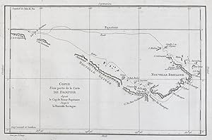
"Carte d'une Partie de la Carte de Dampier depuis le Cap de Bonne Esperance jusqu'a la Nouvelle Bretagne" - New Britain island Papua New GUinea Bismarck Archipelago Oceania Australasia Australia
Philippe de Pretot, Etienne Andre (c. 1710-1787) und E. Dussy:
Lingua: Francese
Editore: Paris 1787
- Mappa
Da: Antiquariat Steffen Völkel GmbH, Seubersdorf, GermaniaAntiquariat Steffen Völkel GmbH
Contatta il venditoreVenditore con 5 stelleCondizione: Usato
EUR 49,99
EUR 30,00 spedizioneSpedito da Germania a U.S.A.Quantità: 1 disponibili
Sehr seltene Kupferstich-Karte Philippe de Pretos's Atlas Universelle aus dem Jahre 1787. -- Blatt-Maße: ca. 33 x 47 cm. -- gut erhalten. || Very rare copper engraved map by E. Dussy out of Philippe de Pretot's Atlas Universelle from 1787. -- in good condition. || Dies ist ein Original! - Kein Nachdruck! - Keine Kopie! | This is… an original! - No reprint! - No copy! // Wir, das Antiquariat Steffen Völkel, kaufen und verkaufen alte Bücher, Handschriften, Zeichnungen, Autographen, Grafiken und Fotografien. Wir sind stets am Ankauf von kompletten Bibliotheken, Sammlungen und Nachlässen interessiert. Sprache: Französisch Gewicht in Gramm: 1500.

"Carte de la Terre des Papous, de la Nouvelle Guinée, et des Isles de Salomon." - Papua New Guinea Oceania Karte map
Philippe de Pretot, Etienne Andre (c. 1710-1787), Robert de Vaugondy und E. Dussy:
Lingua: Francese
Editore: Paris 1787
- Mappa
Da: Antiquariat Steffen Völkel GmbH, Seubersdorf, GermaniaAntiquariat Steffen Völkel GmbH
Contatta il venditoreVenditore con 5 stelleCondizione: Usato
EUR 119,99
EUR 30,00 spedizioneSpedito da Germania a U.S.A.Quantità: 1 disponibili
Sehr seltene Kupferstich-Karte aus Philippe de Pretot's Atlas Universelle aus dem Jahre 1787. -- Blatt-Maße: ca. 33,5 x 49 cm. -- gut erhalten. || Very rare copper engraved map out of Philippe de Pretot's Atlas Universelle from 1787. -- in good condition. || Dies ist ein Original! - Kein Nachdruck! - Keine Kopie! | This is an or…iginal! - No reprint! - No copy! // Wir, das Antiquariat Steffen Völkel, kaufen und verkaufen alte Bücher, Handschriften, Zeichnungen, Autographen, Grafiken und Fotografien. Wir sind stets am Ankauf von kompletten Bibliotheken, Sammlungen und Nachlässen interessiert. Sprache: Französisch Gewicht in Gramm: 1500.

Lingua: Francese
Editore: Paris 1769
- Mappa
Da: Antiquariat Liber Antiqua, Krems an der Donau, , AustriaAntiquariat Liber Antiqua
Contatta il venditoreVenditore con 5 stelleCondizione: Usato
EUR 375,00
EUR 44,50 spedizioneSpedito da Austria a U.S.A.Quantità: 1 disponibili
Blatt ca. 46,5 x 30,5cm, Stich ca. 36,5 x 27,5 cm Kupferstich, koloriert, Blatt ca. 46,5 x 30,5 cm, Stich ca. 36,5 x 27,5 cm, Blatt etwas vergilbt, randlädiert, ein bisschen fleckig, Bug auf der Rückseite verstärkt, schöen Koloration, für das Alter eher guter Zustand Etienne Andre Philippe De Pretot (1708 - 1787) was a royal cen…sor as well as a professor of history at the Royal Academy of Sciences in Paris. He published a variety of geographical material from 1744 onwards until his death in 1787. Interestingly enough his most famous work, 'Atlas Universal', was published in the year of his death (sourc. Wik) Sprache: Französisch.

Editore: Paris. [c.1787] 1787
Da: Peter Harrington. ABA/ ILAB., London, Regno UnitoPeter Harrington. ABA/ ILAB.
Contatta il venditoreVenditore con 5 stelleCondizione: Usato
EUR 101,46
EUR 25,50 spedizioneSpedito da Regno Unito a U.S.A.Quantità: 1 disponibili
Sheet size: 332 x 472 mm Plate size: 264 x 393 mm. Copper engraving. Hand colouring. In fine condition.

Editore: Paris. [c.1787] 1787
Da: Peter Harrington. ABA/ ILAB., London, Regno UnitoPeter Harrington. ABA/ ILAB.
Contatta il venditoreVenditore con 5 stelleCondizione: Usato
EUR 143,24
EUR 25,50 spedizioneSpedito da Regno Unito a U.S.A.Quantità: 1 disponibili
An interesting map of Paris with a highly decorative cartouche. Copperplate engraving with later hand colour. Sheet size: 338 x 476 mm Plate size: 280 x 405 mm In fine condition.

Editore: Paris. 1787 1787
Da: Peter Harrington. ABA/ ILAB., London, Regno UnitoPeter Harrington. ABA/ ILAB.
Contatta il venditoreVenditore con 5 stelleCondizione: Usato
EUR 143,24
EUR 25,50 spedizioneSpedito da Regno Unito a U.S.A.Quantità: 1 disponibili
Attractive map of Asia with text in French on the left on the geography, divisions and borders of the continent. Decorated title cartouche at right. Copper engraving. Excellent condition. Hand coloured. Size: 42 x 28 cm.

Editore: Paris: 1787 1787
Da: Peter Harrington. ABA/ ILAB., London, Regno UnitoPeter Harrington. ABA/ ILAB.
Contatta il venditoreVenditore con 5 stelleCondizione: Usato
EUR 173,08
EUR 25,50 spedizioneSpedito da Regno Unito a U.S.A.Quantità: 1 disponibili
An interesting map of the Lower Rhin with the Electorates of Cologne, Treves, Mayence and the Palatinate of the Rhin. Copper engraving. Hand coloured. Size: 294 x 430 mm Very good condition.

Editore: Cosmographie Universal. 1773 1773
Da: Peter Harrington. ABA/ ILAB., London, Regno UnitoPeter Harrington. ABA/ ILAB.
Contatta il venditoreVenditore con 5 stelleCondizione: Usato
EUR 173,08
EUR 25,50 spedizioneSpedito da Regno Unito a U.S.A.Quantità: 1 disponibili
Attractive map of Portugal. Title and scales at lower right. Copper engraving. Fine condition. Original outline colour. Size: 270 x 375 mm. (10½ x 15 inches).

Editore: Paris. 1787 1787
Da: Peter Harrington. ABA/ ILAB., London, Regno UnitoPeter Harrington. ABA/ ILAB.
Contatta il venditoreVenditore con 5 stelleCondizione: Usato
EUR 173,08
EUR 25,50 spedizioneSpedito da Regno Unito a U.S.A.Quantità: 1 disponibili
An attractive map of Lower Saxony, with a pleasant title cartouche at lower right, scales at lower left. From the Atlas Universal. Copper engraving. Fine condition Later colour. Size: 41 x 26 cm.

Editore: 1787 1787
Da: Peter Harrington. ABA/ ILAB., London, Regno UnitoPeter Harrington. ABA/ ILAB.
Contatta il venditoreVenditore con 5 stelleCondizione: Usato
EUR 173,08
EUR 25,50 spedizioneSpedito da Regno Unito a U.S.A.Quantità: 1 disponibili
Map of south west Germany. Decorated cartouche at top right. 'Explication des Signes' and scales at lower left. Copper engraving. Fine condition. Later colour. 335 x 480 mm.

Editore: Cosmographie Universale. 1787. 1787
Da: Peter Harrington. ABA/ ILAB., London, Regno UnitoPeter Harrington. ABA/ ILAB.
Contatta il venditoreVenditore con 5 stelleCondizione: Usato
EUR 179,05
EUR 25,50 spedizioneSpedito da Regno Unito a U.S.A.Quantità: 1 disponibili
Detailed map of England with ornamental title cartouche and coats of arms. Copper engraving. Fine condition. Light foxing to the margins, not affecting the image. Later colour. Size: 41 x 28 cm. (16 x 11 inches).

Editore: Paris. 1787 1787
Da: Peter Harrington. ABA/ ILAB., London, Regno UnitoPeter Harrington. ABA/ ILAB.
Contatta il venditoreVenditore con 5 stelleCondizione: Usato
EUR 196,95
EUR 25,50 spedizioneSpedito da Regno Unito a U.S.A.Quantità: 1 disponibili
An interesting map of Baviera with a very decorative cartouche. Size: 292 x 440 mm. Copperplate engraving with later hand colour. In fine condition.

Editore: Paris. c.1787 1787
Da: Peter Harrington. ABA/ ILAB., London, Regno UnitoPeter Harrington. ABA/ ILAB.
Contatta il venditoreVenditore con 5 stelleCondizione: Usato
EUR 196,95
EUR 25,50 spedizioneSpedito da Regno Unito a U.S.A.Quantità: 1 disponibili
An interesting map of those countries that comprised the Turkish Empire in Europe. Each separate country is coloured in outline. A handsome and very decorative title cartouche is viewed in lower left corner. Size: 290 x 430 mm. Copperplate engraving with later additional hand colour. Good condition. Some minor foxing.
Editore: Paris. 1787 1787
Da: Peter Harrington. ABA/ ILAB., London, Regno UnitoPeter Harrington. ABA/ ILAB.
Contatta il venditoreVenditore con 5 stelleCondizione: Usato
EUR 196,95
EUR 25,50 spedizioneSpedito da Regno Unito a U.S.A.Quantità: 1 disponibili
Attractive Map of Bavaria, with decorated cartouche at top right, and 'Explication of Signes' at lower right. Published in the Atlas Universal. Copper engraving. Fine condition, good margins. Later colouring. Size: 35 x 27 cm.

Editore: Atlas Universal. 1787 1787
Da: Peter Harrington. ABA/ ILAB., London, Regno UnitoPeter Harrington. ABA/ ILAB.
Contatta il venditoreVenditore con 5 stelleCondizione: Usato
EUR 208,89
EUR 25,50 spedizioneSpedito da Regno Unito a U.S.A.Quantità: 1 disponibili
Map of south east Germany. Decorated cartouche at top right. 'Explication des Signes' and scales at lower left. Copper engraving. Fine condition. Later colour. Size: 34 x 26.5 cm. (13½ x 10½ inches).

Editore: Paris. 1787 1787
Da: Peter Harrington. ABA/ ILAB., London, Regno UnitoPeter Harrington. ABA/ ILAB.
Contatta il venditoreVenditore con 5 stelleCondizione: Usato
EUR 208,89
EUR 25,50 spedizioneSpedito da Regno Unito a U.S.A.Quantità: 1 disponibili
Map of the whole of Germany, which at the time included the Netherlands, cartouche at lower right, scales at lower left. Published in the Atlas Universal. Copper engraving. Fine condition Later colour. Size: 37 x 28.5 cm.

Editore: Paris. c.1790 1790
Da: Peter Harrington. ABA/ ILAB., London, Regno UnitoPeter Harrington. ABA/ ILAB.
Contatta il venditoreVenditore con 5 stelleCondizione: Usato
EUR 208,89
EUR 25,50 spedizioneSpedito da Regno Unito a U.S.A.Quantità: 1 disponibili
An attractive and detailed map of a part of the Rhine in central Germany. Interesting and decorative title cartouche. Copper engraving. Very good condition, good margins, waterstains along lower margin, not affecting map Later colour. Size: 35 x 26 cm.

Editore: Paris. 1787 1787
Da: Peter Harrington. ABA/ ILAB., London, Regno UnitoPeter Harrington. ABA/ ILAB.
Contatta il venditoreVenditore con 5 stelleCondizione: Usato
EUR 232,76
EUR 25,50 spedizioneSpedito da Regno Unito a U.S.A.Quantità: 1 disponibili
Atractive map of present day Netherlands and North West part of Germany, with decorative cartouche at top left, scales at lower right. Published in the Atlas Universal. Copper engraving. Fine condition Later colour. Size: 38 x 28 cm.
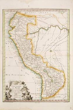
Editore: Cosmographie Universal. 1773. 1773
Da: Peter Harrington. ABA/ ILAB., London, Regno UnitoPeter Harrington. ABA/ ILAB.
Contatta il venditoreVenditore con 5 stelleCondizione: Usato
EUR 262,60
EUR 25,50 spedizioneSpedito da Regno Unito a U.S.A.Quantità: 1 disponibili
Attractive map of Peru. Decorated title cartouche and scales at lower right. Copper engraving. Fine condition. Original outline colour. Size: 27 x 37.5 cm. (10½ x 15 inches).

Editore: Atlas Universal 1787 1787
Da: Peter Harrington. ABA/ ILAB., London, Regno UnitoPeter Harrington. ABA/ ILAB.
Contatta il venditoreVenditore con 5 stelleCondizione: Usato
EUR 262,60
EUR 25,50 spedizioneSpedito da Regno Unito a U.S.A.Quantità: 1 disponibili
Attractive map of Austria, which at the time included most of Southern Germany, part of northeast Italy, the Czech Republic and Slovenia. Title cartouche at top right with five coats of arms. Key at lower right. Copper engraving. Fine condition. Later colouring. Size: 36 x 27 cm. (14 x 10½ inches).

Editore: Nyon l'aine,
- Mappa
Da: Daniel Crouch Rare Books Ltd, London, , Regno UnitoDaniel Crouch Rare Books Ltd
Contatta il venditoreVenditore con 4 stelleCondizione: Usato
EUR 1193,66
EUR 23,18 spedizioneSpedito da Regno Unito a U.S.A.Quantità: 1 disponibili
Cook's rival Double-page engraved chart. Alexander Dalrymple's chart records the tracks of a number important voyages of discovery, funded by competing nations, in the South Pacific: Alvaro Mendana de Neyra, discoverer of the Solomon Islands, in 1595; Theodore Gerrards, who claimed to see mountains southwest of South America in…1599; Pedro Fernandes de Quiros and Louis Vaez de Torres in 1606, showing them traversing what is now known as Torres Strait, although the source of this assertion is not provided in the book. The evidence had in fact come from his study of original documents and charts of Torres taken by the British from the Spanish archives when they captured Manila in 1762; Jacob Le Maire and Willem Schouten's discovery of the strait named after Le Maire, and crossing of the Pacific, in 1617; Jacob Roggeveen, who found Easter Island, in 1622; and Abel Tasman's voyages of 1642 and 1644. The plate was originally engraved for Dalrymple's rare 'An account of the discoveries made in the south Pacifick Ocean, previous to 1764' (1767), and subsequently reprinted widely in his 'An Historical Collection of the Several Voyages and Discoveries in the South Pacific Ocean' (1770-1771). This French edition was probably, according to the National Library of Australia, included in the 'Atlas universal pour l'etude de la geographe et de l'histoire ancienne et moderne par Mr. Philippe et autres auteurs' (1787). The mapmaker The first hydrographer to the British Admiralty, Alexander Dalrymple (1737-1808) is best known for his researches regarding a great Southern Continent, as well as a proponent of the search for the Northwest Passage (thereby influencing Vancouver's survey). Through family connections, Dalrymple was made a "writer" (the most junior position) for the East India Company and sent to Madras where he arrived in May 1753. He was afforded access to Robert Orme's library and grew increasingly fascinated with the EIC's activities in Burma, Indo-China and Borneo. He turned down a promotion so that he might undertake a voyage to the east of his own. "In February 1759, Pigot freighted the Cuddalore (Captain George Baker) for Dalrymple 'to attempt to discover a new route to China through the Molucca Islands and New Guinea'. Dalrymple made three voyages between 1759 and 1764 to the Philippines, Borneo, and Sulu. In the first, based at Canton (Guangzhou), he reconnoitred Borneo, the Philippines, and the coast of Cochin-China. For the second, in the London in 1762, he had James Rennell as companion for a voyage to Sulu and Balambangan, where he had obtained for the company a grant of land. In Madras in 1763 he went through the formality of resignation, confident of reinstatement, to return to London to promote a trading settlement at Balambangan. En route to Canton for passage to England he became provisional deputy governor at Manila for a short period in April 1764, in the aftermath of the treaty of Paris, and he arrived in London in the summer of 1765 " (ODNB) Literature: Tooley, 'The Mapping of Australia', 961.
Lingua: Francese
- Mappa
Da: Antiquariat Renner OHG, Albstadt, , GermaniaAntiquariat Renner OHG
Contatta il venditoreVenditore con 5 stelleCondizione: Usato - Molto buono
EUR 150,00
EUR 45,00 spedizioneSpedito da Germania a U.S.A.Quantità: 1 disponibili
Kein Einband. Condizione: Gut. Unkolorierte Kupferstichkarte 39,5 x 26 cm. Blattgröße 43,5 x 29 cm. Oben links Titelkartusche, unten links Zeichenerklärungen, unten rechts Maßstabe (Lieues communes d'Allemagne, Lieues communes de France). Ausserhalb des Kartenbildes unten links "Moithey. Ing. Geo. del. et Sculp", unten rechts "H…erault Scrip.".- Die Karte ist gering gebräunt, einmal in der Mitte gefaltet, Falz hinterlegt.

- Mappa
Da: Altea Antique Maps, London, , Regno UnitoAltea Antique Maps
Contatta il venditoreVenditore con 5 stelleCondizione: Usato
EUR 405,84
EUR 40,56 spedizioneSpedito da Regno Unito a U.S.A.Quantità: 1 disponibili
Paris, 1787. Coloured. 290 x 420mm. Narrow margins. Eighteenth century map of China, with Korea and Japan, drawn by the mathematician and geographer, Maurille-Antoine Moithey. The Sea between Korea and China is named 'Hoang-Hai or Mer Jaune ' (Yellow Sea). The Great Wall of China is also shown.

- Mappa
Da: Altea Antique Maps, London, , Regno UnitoAltea Antique Maps
Contatta il venditoreVenditore con 5 stelleCondizione: Usato
EUR 596,83
EUR 40,56 spedizioneSpedito da Regno Unito a U.S.A.Quantità: 1 disponibili
Paris, 1787. Coloured. 280 x 420mm. Eighteenth century map of Italy,drawn by the mathematician and geographer, Maurille-Antoine Moithey. The title cartouche is decorated with the papal coat of arms.


